The Bay Area is famous for many things, but its weather might be the most genuinely strange. No other urban region in the United States packs this much climate variety into this small a geographic footprint. The city itself has a dense set of San Francisco microclimates. On a typical July afternoon, San Francisco sits at 65 degrees under a gray marine ceiling while Walnut Creek, roughly 25 miles east, bakes at 95 degrees under full sun. That is not a weather anomaly. That is the baseline, created by three geographic factors that, in combination, produce something that does not exist anywhere else in California: more distinct microclimates within 100 miles than most regions have within 1,000.
What Is a Microclimate, and Why Does the Bay Area Have So Many?
A microclimate is a localized area where weather conditions differ meaningfully from the surrounding region. The word gets used loosely, but in meteorological terms it refers to measurable, consistent differences caused by geography, elevation, proximity to water, or wind patterns. Microclimates exist everywhere to some degree. A city block sheltered by tall buildings is a microclimate. A valley that collects cold air at night is a microclimate. What makes the Bay Area unusual is not that microclimates exist here, but that they are extreme, they stack densely on top of each other, and they are driven by multiple reinforcing physical forces operating simultaneously.
Most coastal regions have a gradient that fades gradually as you move inland: a bit warmer here, a bit drier there. The Bay Area does not work that way. The transitions here are sharp. You cross a ridge and the temperature jumps 15 degrees. You drop into a valley and the wind disappears. You climb 400 feet and emerge from the fog into clear blue sky. The geographic complexity that drives this is visible on any topographic map: a bay, multiple mountain ranges, dozens of valleys, and a coastline that faces west into the coldest stretch of Pacific water in California.
The Three Geographic Factors That Create Extreme Weather Variation
Three things converge here that do not converge anywhere else in California with the same intensity. The first is the San Francisco Bay itself: a massive inland water body that creates a physical and thermal divide between coastal and inland weather systems. The second is the surrounding mountain terrain: the Diablo Range to the east, the Santa Cruz Mountains to the south, and the Berkeley Hills forming an inner wall. The third is elevation, which in the Bay Area changes by thousands of feet within just a few miles and determines whether a given location sits inside or above the marine layer.
These three factors do not just add together; they amplify each other. The cold Pacific Ocean generates the marine layer. The mountains determine where that layer can and cannot go. Elevation determines which neighborhoods sit inside the layer and which rise above it. Together, they create a region where local weather is hyperspecific to geography in ways that no regional forecast can capture accurately. This is why Bay Area residents learn to check weather for their specific neighborhood or destination rather than trusting a single city-wide reading.
How the San Francisco Bay Itself Divides the Region
The bay is the central organizing fact of Bay Area weather. It sits between the coast and the inland valleys, and its presence means that air traveling from the Pacific to the interior must cross a major water body before it can reach communities like Livermore or Walnut Creek. That crossing changes the air in predictable ways: it picks up humidity from the bay surface, it loses some of its coldest edge as it travels over water that is warmer than the ocean, and it slows and diffuses before reaching the inland hills.
The bay also creates a sharp east-west divide in microclimate character. Communities on the western and northern shore sit in direct contact with marine air influence: Berkeley, Albany, Richmond, and San Rafael all receive cool, moist air more readily than communities on the bay's eastern and southern shores. San Jose, at the southern end of the bay, has its own microclimate pattern that reflects both its distance from the ocean and the channeling effects of the bay valley. The bay is not just a landmark; it is a weather system in itself.

Why Mountains Matter More Than Distance Here
In a flat region, moving 20 miles inland produces a gradual change in weather conditions. In the Bay Area, moving 20 miles inland means crossing at least one significant mountain range, and that crossing changes everything. The Diablo Range, which rises to over 3,800 feet at Mount Diablo, acts as the primary barrier between the warm inland valleys and the cooler bay-influenced air to the west. Air masses that cannot clear the range must go around it, funneling through passes and gaps. Air that does clear the range warms through compression as it descends on the lee side, a process called adiabatic warming that adds roughly 5 degrees for every 1,000 feet of descent.
This is why communities directly behind the Diablo Range, in the Livermore Valley and the Tri-Valley area, are consistently 15 to 20 degrees warmer than communities at the same latitude on the bay side. The mountains create a rain shadow effect in winter, leaving these inland areas significantly drier, and a heat trap in summer, blocking marine cooling and allowing solar heating to accumulate unchecked. The Berkeley Hills, lower in elevation but positioned directly east of the bay, perform a similar function for East Bay communities. Orinda sits in a noticeably different climate than Berkeley, separated by a ridge that is only a few hundred feet taller than the marine layer ceiling.
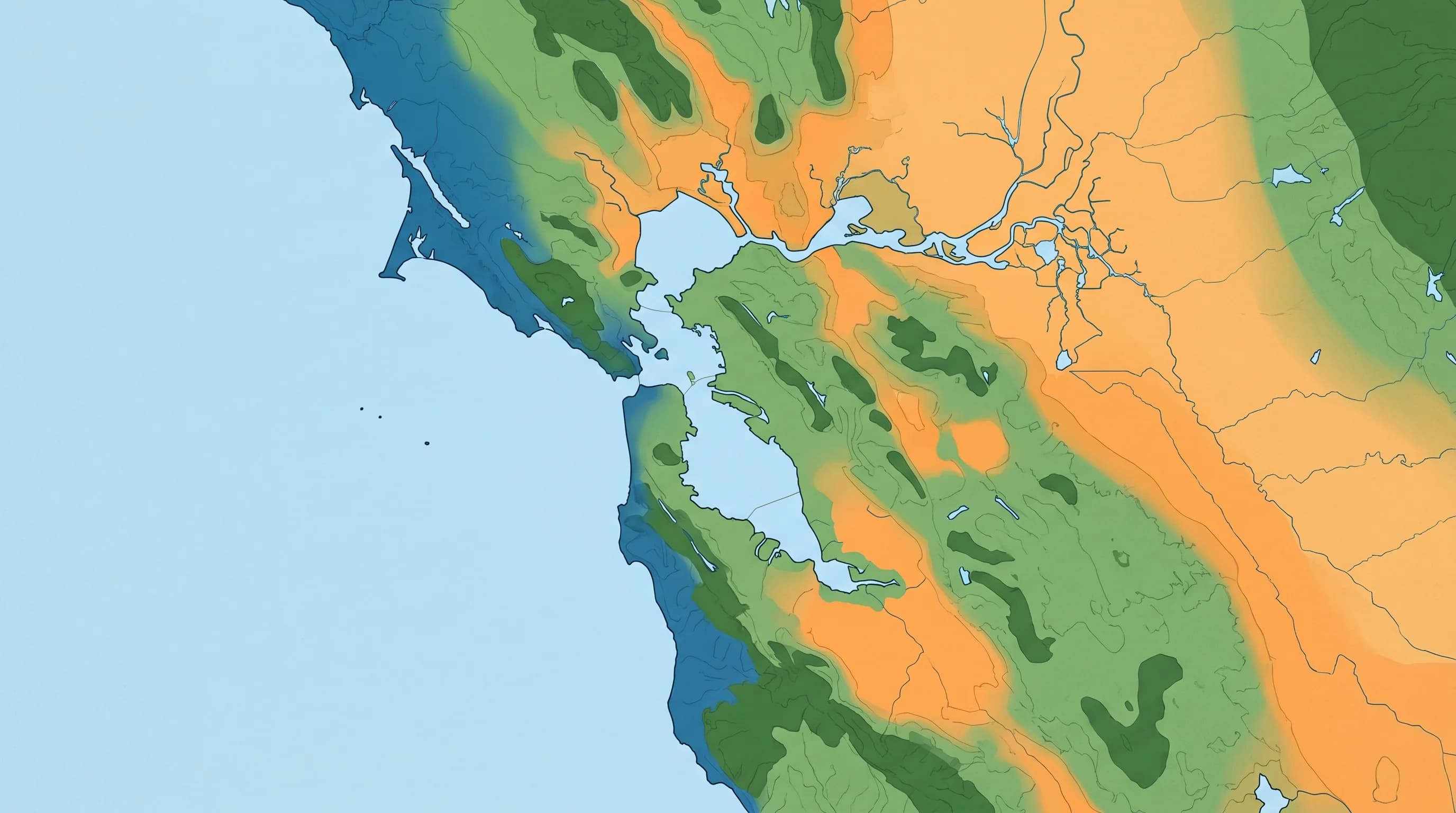
Coastal vs. Inland vs. Foothill: The Main Microclimate Zones
The Bay Area breaks into four recognizable microclimate zones, each with distinct temperature ranges and weather patterns. The coastal zone, which includes San Francisco, Daly City, Pacifica, and Half Moon Bay, is the coolest and foggiest. Summer highs here typically run 62 to 66 degrees, and morning fog is present on most days from June through August. The bay-side zone, which includes Oaklandand Berkeley, sits warmer and clearer at 75 to 78 degrees in summer, benefiting from the bay water's moderating influence without bearing the full brunt of Pacific fog.
The inland valley zone, covering San Jose, Pleasanton, and Fremont, runs 82 to 88 degrees in summer and receives the marine layer only on unusually strong fog days. Finally, the foothill zone, which includes Walnut Creek, Livermore, and Concord, is the hottest and driest zone, regularly reaching 85 to 95 degrees in summer and occasionally pushing above 100 during heat events. These four zones exist within a circle of roughly 50 miles in diameter. Nothing about this pattern is unusual weather behavior for the Bay Area. This is simply what the region is.
How Elevation Changes Everything Within a Single City
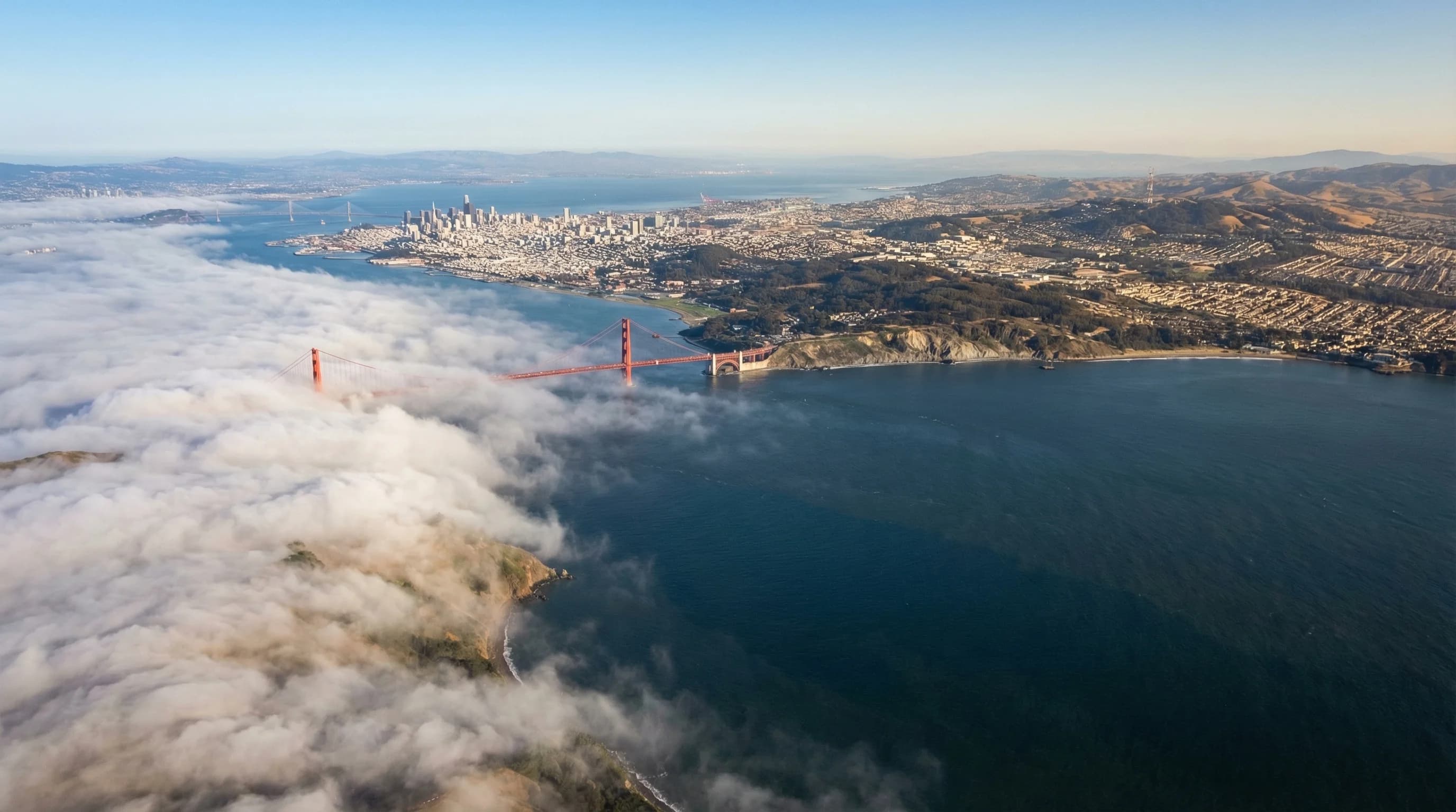
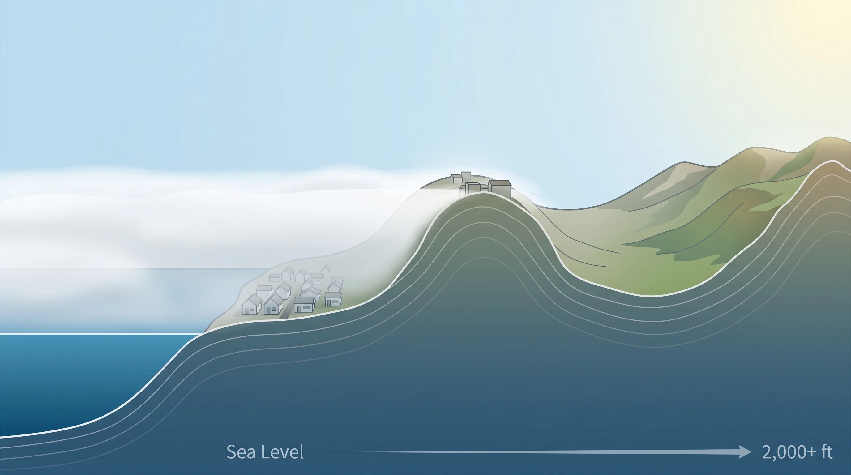
The marine layer that floods the Bay Area coast in summer is a physical object with a ceiling. That ceiling typically sits between 300 and 800 feet above sea level, depending on how strong the marine influence is on a given day. This means that elevation is not just a comfort factor in the Bay Area; it is literally the line between fog and sunshine. Neighborhoods below 400 feet are inside the layer on most summer days. Neighborhoods above 800 feet sit above it.
This plays out in dramatic ways within individual cities. In San Francisco, the neighborhoods at sea level in the Outer Sunset and Ocean Beach corridor are often completely fogged in when the Castro and Twin Peaks are in clear sun a mile away and 400 feet higher. In the East Bay, hillside neighborhoods like Montclair and the upper reaches of the Oakland Hills regularly see sunshine while lower Richmond neighborhoods sit in gray. Every 1,000 feet of elevation gain corresponds to roughly 3 to 4 degrees of cooling in normal atmospheric conditions, but in the fog zone, the relationship between elevation and weather is even more dramatic because it determines which side of the marine layer you are on.
This is the defining feature of Bay Area weather literacy: the people who live here long enough stop thinking about weather in terms of city names and start thinking about it in terms of elevation, compass direction from the bay, and distance from the nearest ridge. A house on the west-facing slope of a coastal hill and a house on the east-facing slope of the same hill live in different climates. That is not an exaggeration. It is geography doing exactly what geography does, and nowhere in the country does geography do it with more consequence for daily life than here.