Palo Alto and Half Moon Bay are separated by roughly 15 miles and the Santa Cruz Mountains. That distance and that ridge create a weather contrast that is among the most dramatic in the entire Bay Area. On a typical July afternoon, Palo Alto sits at 82 degrees Fahrenheit under clear skies, while Half Moon Bay, on the Pacific side of the same mountains, sits at 58 degrees in thick coastal fog. The Peninsula is a study in how a single north-south mountain range can divide a region into two completely different climate worlds. What happens between those two endpoints, across the dozens of Peninsula communities that lie along Highway 101 and Highway 1, tells the story of how Bay Area geography shapes daily weather experience.
The Santa Cruz Mountains as Weather Divide
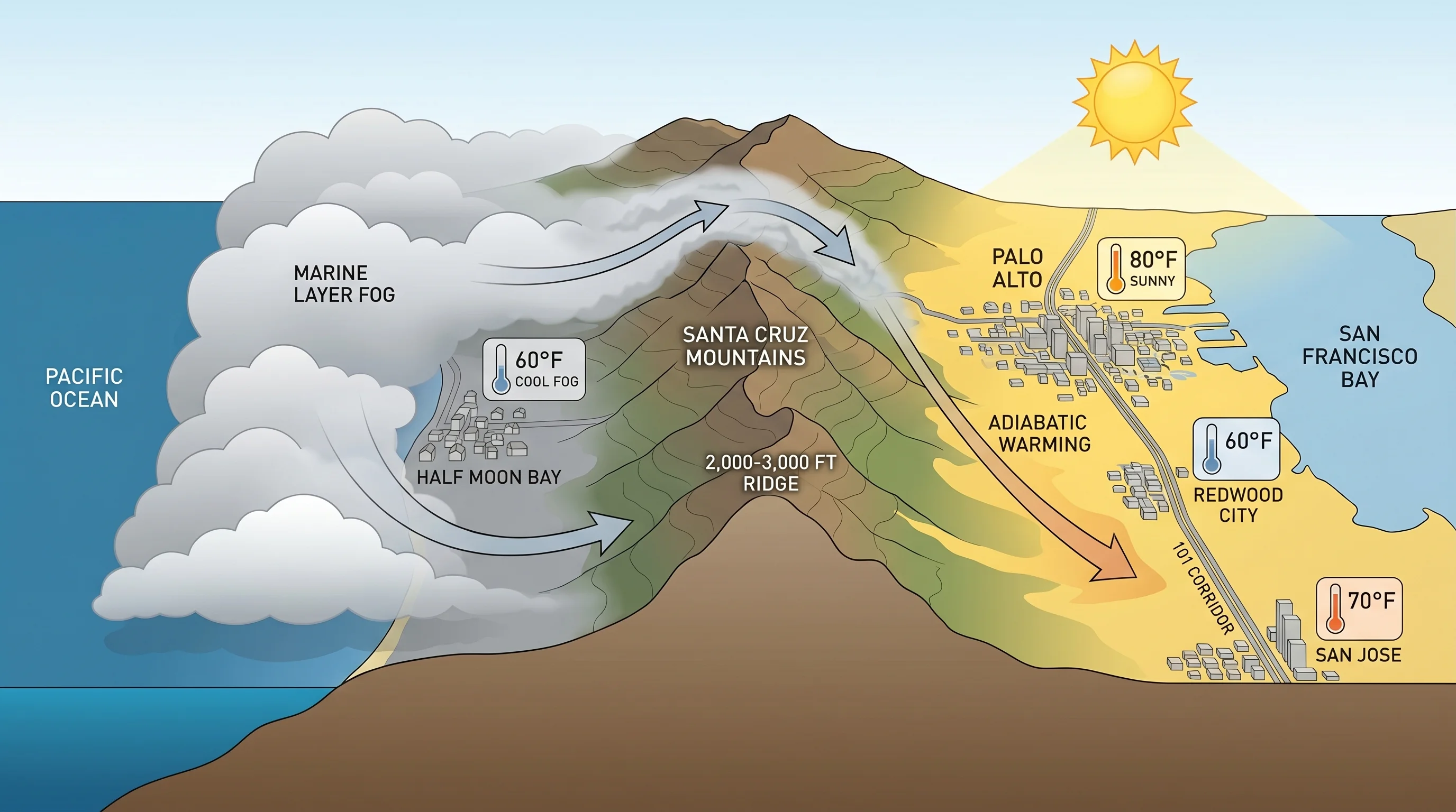
The Santa Cruz Mountains run down the spine of the San Francisco Peninsula from the San Francisco hills in the north to the Santa Cruz area in the south. They range in elevation from around 2,000 feet near San Carlos to over 3,000 feet at their highest points above the South Bay. This ridge acts as a barrier to the marine layer that forms over the Pacific and is pushed inland by the North Pacific High during summer.
The marine layer flows eastward from the coast, rises as it hits the mountains, and typically cannot clear the highest terrain. It fills the coastal valleys and ridges with fog and drops its moisture as it cools against the western slopes, while the eastern side of the mountains, where Palo Alto, Menlo Park, and the Peninsula bay communities sit, remains in the rain shadow and receives only the drier, warmer air that makes it over the crest. The result is a persistent structural temperature and fog gradient running west to east across the Peninsula.
Half Moon Bay: The Coastal Extreme
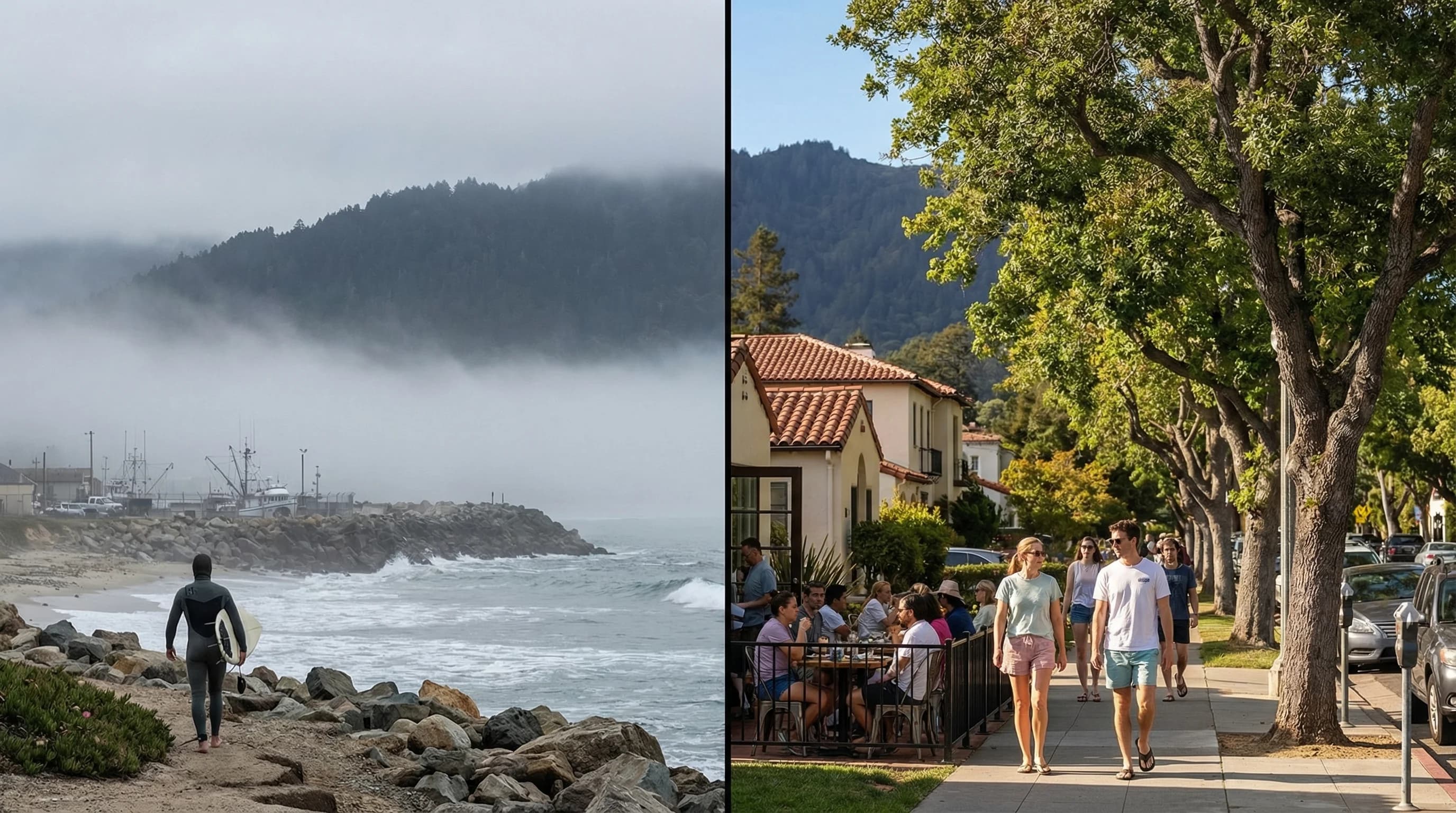
Half Moon Bay occupies a position on the San Mateo County coast that gives it some of the most persistent marine layer conditions in the Bay Area. It faces the Pacific directly, has low terrain to its south and west, and sits in the path of the predominant summer onshore flow. Summer fog is not an occasional visitor in Half Moon Bay; it is the baseline condition from which exceptions occur.
July and August average highs in Half Moon Bay sit around 60 to 63 degrees Fahrenheit. Mornings are almost universally foggy, and many days the fog never fully burns off. When it does clear, the window of sunshine is typically brief: a few hours in the early afternoon before the marine layer rebuilds. The ocean temperature off Half Moon Bay runs in the low to mid-50s Fahrenheit, cold enough to feel dangerous if you are in the water for more than a few minutes.
This coastal climate has its advantages: Half Moon Bay almost never experiences the heat waves that regularly affect the inland Peninsula. When Palo Alto hits 100 degrees during an inland heat event, Half Moon Bay sits at 65. The coastal strip remains remarkably stable year-round, with average temperatures varying less than 15 degrees between summer and winter. If you prize cool, calm, and consistently moderate over warm and sunny, Half Moon Bay is hard to beat anywhere in Northern California.
The Peninsula Gradient: From Bay to Coast
The Peninsula communities along Highway 101, Redwood City, Menlo Park, Palo Alto, San Jose, occupy the sheltered eastern side of the Santa Cruz Mountains and experience weather that is fundamentally different from the coastal strip. These are warm, often sunny places in summer. Palo Alto's July average high is around 80 degrees Fahrenheit, and summer heat events regularly bring temperatures into the 90s.
Even within the 101 corridor, there is a meaningful north-south gradient. San Mateo and Redwood City, in the northern Peninsula, sit closer to the Bay's cooling influence and experience more moderate temperatures than the South Bay communities. San Jose, at the southern end of the Bay, is farther from marine influence and regularly runs five to ten degrees hotter than Redwood City on summer afternoons.
The communities that sit in the foothills of the Santa Cruz Mountains, Los Altos Hills, Portola Valley, Woodside, occupy an intermediate zone. They are shielded from the marine layer enough to be warmer than the coast, but their elevation and slightly west-facing exposures mean they receive some of the cooling influence that doesn't make it to the valley floor. On summer evenings, the hills cool faster than the valley communities, making foothill locations pleasant when the valley floor is still radiating stored heat.
Fog Gap Communities: San Gregorio and Pescadero
South of Half Moon Bay, the coast becomes even more consistently foggy as the Santa Cruz Mountains grow taller and the coastal valleys narrow. The communities of San Gregorio, Pescadero, and Año Nuevo sit in one of the foggiest stretches of the California coast. Marine fog here is present for most of the summer and occurs frequently throughout the year. The agricultural communities of this coast, artichoke and Brussels sprout farms, primarily, depend on the cool, moist conditions that the fog provides.
There are occasional gaps in the mountains where marine air pushes more aggressively into the interior, primarily through the passes near Portola Valley and Los Altos Hills. On days when the marine push is unusually strong, fog can filter through these gaps into the Palo Alto area, temporarily reversing the normal weather divide. But these events are the exception; on most summer days, the Santa Cruz Mountains hold the line and the Peninsula weather gradient remains stark and predictable.
The Peninsula's weather contrast is a microcosm of California's larger coastal-inland divide, compressed into a space where you can drive between the climate extremes in 20 minutes. For residents, this means easy access to two completely different outdoor experiences depending on which direction they drive. For visitors, it means that hotel location on the Peninsula matters enormously; a few miles and a mountain range can mean the difference between a foggy 58-degree day and a sunny 85-degree afternoon.