A coastal flood advisory is the lowest of three alert levels the National Weather Service issues when ocean water threatens to push onto shore. Above it sits the coastal flood watch, and the most severe is the coastal flood warning. Each level communicates a different degree of certainty and danger, and knowing which is which determines whether you need to stay alert, start preparing, or take immediate action. In the Bay Area, where king tides, winter storms, and atmospheric rivers can combine to push water well above normal levels, these alerts directly affect communities from Pacifica to the Embarcadero.
What Are the Three Levels of Coastal Flood Alerts?
The National Weather Service (NWS) uses a three-tier system for coastal flooding, just as it does for most weather hazards. The tiers, from least to most severe, are advisory, watch, and warning. Each one answers a slightly different question: an advisory says "minor flooding is expected or occurring," a watch says "significant flooding is possible in the next 12 to 48 hours," and a warning says "significant flooding is expected or already happening." The differences in wording are deliberate. They reflect both the severity of the anticipated flooding and the confidence forecasters have in its occurrence.
A coastal flood advisory is issued when minor coastal flooding is expected. Minor flooding means water reaches areas that are not normally wet: low-lying parking lots, coastal trails, harbor docks, and portions of beach access roads. It causes inconvenience and possibly minor property damage, but it does not pose a direct threat to life. In the Bay Area, the NWS office in Monterey (which covers the coast from Sonoma County south) issues coastal flood advisories several times per year, most commonly during winter king tide windows and when storm systems coincide with higher-than-normal tides.
A coastal flood watch means conditions are favorable for moderate to major coastal flooding within the next 12 to 48 hours, but forecasters are not yet certain enough to issue a warning. A watch is a planning alert: it tells you that significant flooding is plausible and you should start preparing. You might see a watch issued when a strong storm system is approaching and tide tables show high astronomical tides in the same window, but the storm track or timing could still shift.
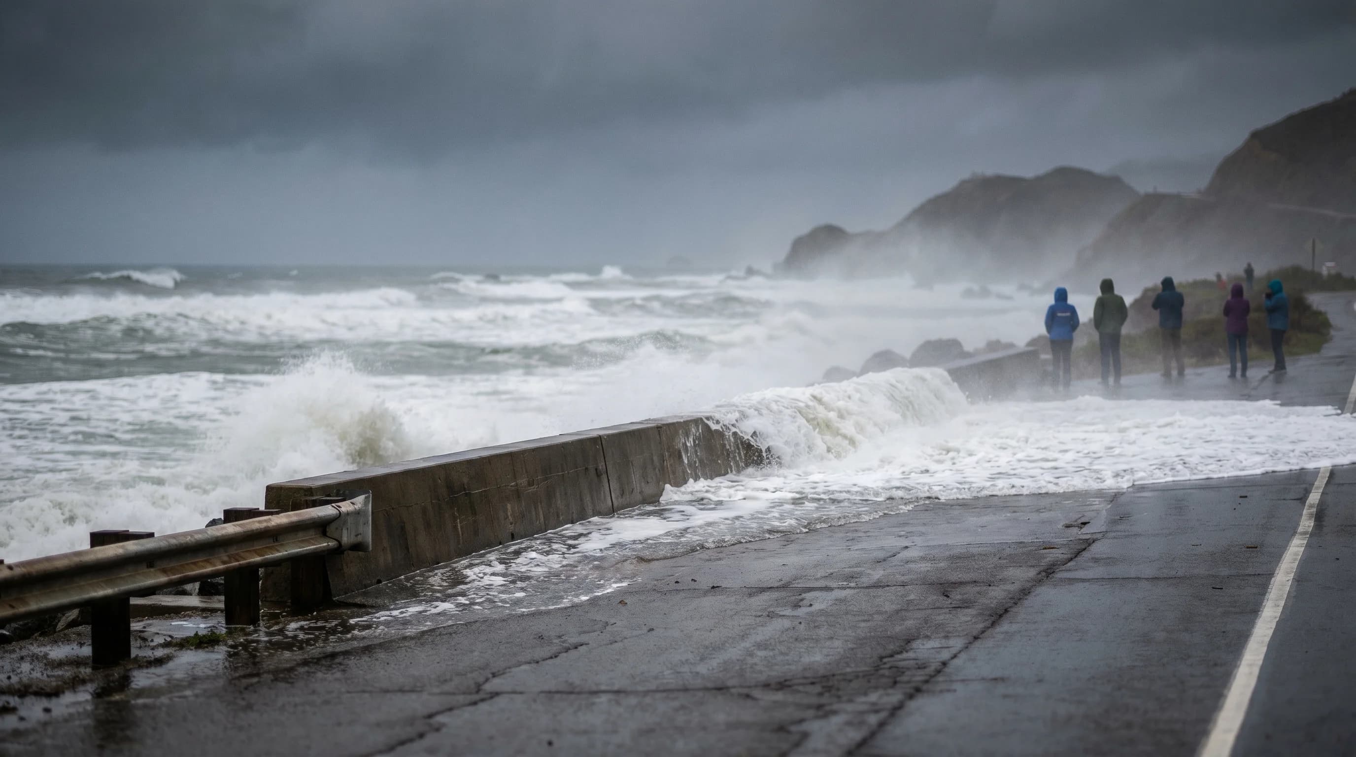
A coastal flood warning is the most severe product. It means moderate to major coastal flooding is expected or already occurring. This is the "take action now" alert. Major coastal flooding can inundate roads, damage structures near the waterline, erode beaches and bluffs, and create dangerous conditions for anyone near the coast. Along the Bay Area's outer coast, a coastal flood warning typically accompanies large swells, storm surge, and high tides arriving together.

What Causes Coastal Flooding in the Bay Area?
Coastal flooding is not a single phenomenon. It results from the interaction of several forces that can overlap or amplify each other. The most important are astronomical tides, storm surge, wave runup, and river discharge into the Bay.

Astronomical tides provide the baseline. The highest predicted tides of the year, king tides, occur in December and January when the sun, moon, and Earth align at their closest orbital positions. At the San Francisco tide gauge (NOAA Station 9414290), king tides typically reach 6.5 to 7.0 feet above mean lower low water, roughly 1 to 2 feet above average high tides. On their own, king tides can flood the lowest-lying shoreline areas.
Storm surge adds to that baseline. When a strong low-pressure system moves onshore, the combination of low barometric pressure and sustained onshore winds pushes ocean water higher than the predicted tide. Bay Area storm surge during major winter storms typically adds 1 to 2 feet above predicted tide levels. During the January 2023 atmospheric river sequence, storm surge combined with high tides to push water levels at the San Francisco gauge above 7.5 feet, flooding portions of the Embarcadero and low-lying areas around Sausalito.
Wave runup is the additional height that breaking waves reach on the shoreline, and it matters most on the open coast. At Pacifica, Half Moon Bay, and Stinson Beach, large swells from North Pacific storms can produce wave runup of 5 to 10 feet above the still water level. This is why coastal flood warnings on the outer coast often accompany high surf warnings: the two hazards share the same storm source.
Inside San Francisco Bay, wave runup is less of a factor, but river and creek discharge matters more. When atmospheric rivers deliver heavy rainfall to Bay Area watersheds, the resulting freshwater runoff raises Bay water levels on top of whatever the tide is doing. This compound flooding, where high tides, storm surge, and river discharge converge, is the scenario that produces the most dangerous coastal flooding inside the Bay.
Where Coastal Flooding Hits the Bay Area
The Bay Area's coastal flood risk is split between the open Pacific coast and the interior Bay shoreline, and the two behave differently. On the outer coast, from Stinson Beach south through Pacifica and Half Moon Bay, the primary threats are wave-driven flooding and bluff erosion. Pacifica's coastal bluffs have lost several apartment buildings to erosion over the past two decades, and Esplanade Avenue regularly floods during large swell events coinciding with high tides. Ocean Beach in San Francisco closes sections of the Great Highway multiple times per winter when waves overrun the seawall.
Inside the Bay, the vulnerable areas are those sitting at or near sea level: the Embarcadero in San Francisco, portions of Alameda, Foster City (built entirely on bay fill), and the South Bay communities near Alviso. These areas flood from high tides amplified by storm surge rather than from wave action. King tides alone can push water onto the Embarcadero sidewalks and into parking areas along the Sausalito waterfront. Add storm surge from a winter storm, and the flooding extends further inland and lasts longer.
For a detailed look at which communities face the highest flood risk, including FEMA flood zone designations and sea level rise projections, see our guide to Bay Area flood zone maps.
How to Respond to Each Alert Level
When the NWS issues a coastal flood advisory, the message is: be aware and use common sense. Minor flooding is expected in the lowest-lying coastal areas. Avoid parking in lots adjacent to the waterline. Do not walk on jetties, seawalls, or coastal rocks during high tide windows. Check tide tables and plan beach visits around lower tides. If you live or work near the shoreline, move valuables above potential water levels.
A coastal flood watch requires more active preparation. Move vehicles away from flood-prone areas. Review evacuation routes if you live in a low-lying coastal zone. Secure outdoor items near the waterline. Pay close attention to forecast updates, because a watch may be upgraded to a warning as the event approaches and forecast confidence increases. The watch-to-warning upgrade often happens 12 to 24 hours before the expected flooding.
A coastal flood warning demands immediate action. Stay away from the coastline and flood-prone areas. Do not drive through flooded roads, even if you think you know the depth. Just 12 inches of moving water can carry away a vehicle. If you are in a flood-prone area and officials issue evacuation orders, leave promptly. After the event, be cautious returning to flooded areas: undermined roads, damaged seawalls, and debris in the water create ongoing hazards.
How to Track Coastal Flood Alerts in the Bay Area
The NWS office in Monterey (WFO MTR) issues coastal flood products for the Bay Area coast. You can view active alerts at the NWS San Francisco Bay Area office website or through the NWS alerts API. The NOAA tide gauge at San Francisco (Station 9414290) provides real-time water level data at tidesandcurrents.noaa.gov, which is useful for comparing actual water levels against predicted tides in real time. When actual levels run significantly above predictions, that difference is the storm surge component, and it tells you how much extra water the weather is adding.
The California Coastal Commission and local emergency management agencies also relay NWS alerts through county notification systems. In San Mateo County, where Pacifica and Half Moon Bay face the most frequent coastal flood events, the county uses the SMC Alert system for emergency notifications. Marin County's Alert Marin system covers the Stinson Beach and Sausalito coastline. Signing up for your county's emergency notification system is the single most reliable way to receive coastal flood alerts directly.
Coastal flooding in the Bay Area is becoming more frequent as sea levels rise. The San Francisco tide gauge has recorded approximately 9 inches of sea level rise since 1900, and moderate projections call for an additional 1 to 3 feet by 2100. That means events that currently require a strong storm plus a king tide to produce significant flooding will eventually happen on ordinary high tides. Understanding the alert system now, while coastal flooding is still mostly an event-driven hazard rather than a daily one, gives you the framework to respond effectively as these events become more common. Check Bay Area ocean conditions and tide forecasts before any winter coastal outing, and take every NWS coastal flood alert seriously.