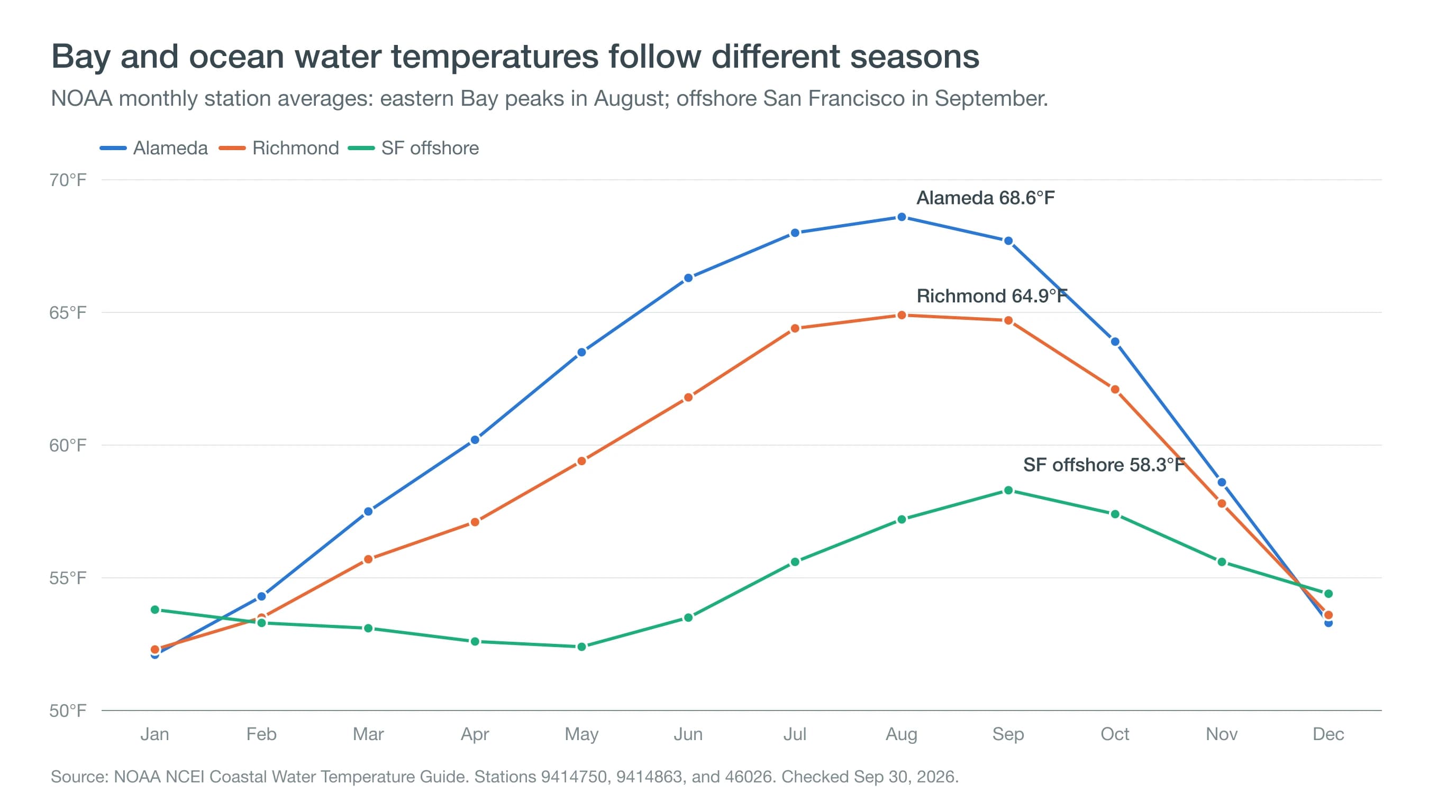
San Francisco Bay does not have one water temperature. The eastern Bay warms more in summer than the exposed Pacific coast, while water near the Golden Gate is strongly influenced by the ocean and tides. NOAA monthly averages range from about 52°F in winter to 69°F in August at Alameda; offshore San Francisco averages about 52–58°F through the year. Use the recent NOAA readings above for the measured temperature at each named station today, and the monthly table below for seasonal context.
San Francisco Bay water temperature: Bay versus ocean
Water in sheltered, shallow parts of the Bay can absorb heat and warm more than the open coast. Alameda and Richmond therefore have a larger seasonal temperature swing than the offshore San Francisco buoy. Conditions also vary with depth, tidal exchange, wind, and the exact shoreline location. An Alameda reading describes that station, not all of San Francisco Bay, and an offshore buoy cannot tell you the exact water temperature at a beach. A warm afternoon air forecast does not mean the water is warm.
Our recent-temperature table uses measured NOAA observations, checked hourly in a shared update. The observation time is the sensor's measurement time. A delayed reading remains visible for up to 24 hours with its original timestamp; after that, we show it as unavailable rather than presenting an old number as today's temperature.
San Francisco Bay and ocean water temperatures by month
These NOAA Coastal Water Temperature Guide averages show why the Bay and the Pacific need separate answers. Alameda and Richmond peak in August, while the San Francisco offshore buoy peaks in September. Its lowest monthly average is in May. October is still relatively mild offshore, but October–November is not a universal warmest-water window for this region.
| Month | Alameda | Richmond | San Francisco offshore (18 nautical miles west) |
|---|---|---|---|
| Jan | 52.1°F | 52.3°F | 53.8°F |
| Feb | 54.3°F | 53.5°F | 53.3°F |
| Mar | 57.5°F | 55.7°F | 53.1°F |
| Apr | 60.2°F | 57.1°F | 52.6°F |
| May | 63.5°F | 59.4°F | 52.4°F |
| Jun | 66.3°F | 61.8°F | 53.5°F |
| Jul | 68.0°F | 64.4°F | 55.6°F |
| Aug | 68.6°F | 64.9°F | 57.2°F |
| Sep | 67.7°F | 64.7°F | 58.3°F |
| Oct | 63.9°F | 62.1°F | 57.4°F |
| Nov | 58.6°F | 57.8°F | 55.6°F |
| Dec | 53.3°F | 53.6°F | 54.4°F |
These are long-term, station-specific averages, not a forecast or a reading at a swimming beach. NOAA's averaging records differ by station. Source: NOAA NCEI, Alameda station 9414750, Richmond station 9414863, and San Francisco buoy 46026; checked September 30, 2026. Individual days can be warmer or colder.
Water temperatures at Bay Area beaches and waterfronts
Find your shoreline below before choosing a reference reading. We do not have a verified local temperature sensor for every beach, marina, or swimming cove in this first version. Where only a regional reference is available, it is labeled by the station's actual location in the table above.
Ocean Beach, San Francisco water temperature
Ocean Beach faces the Pacific. Buoy 46026, 18 nautical miles west of San Francisco, gives measured offshore context, not a temperature at the surf line. Wind and upwelling can make nearshore water different. The National Park Service advises against swimming or wading at Ocean Beach because of dangerous currents and surf; a warmer reading does not remove those hazards.
Aquatic Park and the San Francisco waterfront
Aquatic Park is a Bay swimming cove, not an open-ocean beach. Its water is influenced by tides and exchange through the Golden Gate. We have not verified a recent local sensor for Aquatic Park in this dataset. San Francisco NOAA station 9414290 returned no recent water-temperature observations when checked September 30, 2026; we do not replace it with an Alameda or offshore reading under a San Francisco label. Check current local swimming-club observations and posted conditions for the cove itself.
Sausalito and Richardson Bay water temperature
Sausalito's Bay-facing waterfront and shallow Richardson Bay should not be treated as the exposed Marin coast. Their temperatures can differ with depth and tides. This table does not contain a verified Sausalito or Richardson Bay sensor. Richmond is a measured Bay reference across the water, not an exact Sausalito temperature; offshore San Francisco is a separate ocean reference.
Rodeo Beach water temperature
Rodeo Beach faces the Pacific, so buoy 46026 supplies regional offshore context. It is not a thermometer at Rodeo Beach. Rodeo Lagoon is a separate body of water and must not be substituted for the ocean. The National Park Service prohibits swimming in the lagoon and describes the beach's surf hazards.
Berkeley Marina water temperature
Berkeley Marina is on the eastern Bay, where water can be warmer than the Pacific coast during summer. This dataset has no verified temperature sensor at Berkeley Marina. Alameda and Richmond supply eastern-Bay context at their own measurement locations; neither should be presented as today's exact Berkeley reading.
Alameda water temperature
NOAA station 9414750 provides a measured Alameda reading in the recent table. It is useful local Bay information, though a station reading still may differ from the shallows at Alameda's beaches. Its monthly averages illustrate the eastern Bay's summer warmth and winter cooling.
Santa Cruz, Monterey Bay, and Half Moon Bay
Santa Cruz is on the northern shore of Monterey Bay. NOAA's Monterey shoreline station 9413450 and offshore buoy 46042 provide different regional references, not measurements at Santa Cruz Main Beach or Capitola. For Half Moon Bay, buoy 46012 is an offshore reference, not a reading at the harbor or a swimming beach. Sunshine and shelter on land do not guarantee warmer water.
Why the Pacific off San Francisco is so cold
The California Current carries relatively cool water south along the coast. Coastal upwelling adds to that cooling: northwesterly winds move surface water offshore, and colder water rises to replace it. Upwelling is especially important in spring and summer, so ocean water can stay cold even on a hot day. The same cool ocean helps create the marine layer and coastal fog.
As upwelling winds relax, the surface can warm into late summer and early fall. The timing varies by station and year. The Bay has its own heating and tidal patterns, which is why a single seasonal rule cannot describe every waterfront.
Swimming, cold water, and wetsuits
Temperature is only one part of choosing whether to enter the water. Cold water can cause an involuntary gasp, rapid breathing, and loss of swimming ability; hypothermia risk depends on exposure, clothing, body size, and other conditions. There is no fixed safe duration that applies to everyone. See the National Weather Service's cold-water guidance.
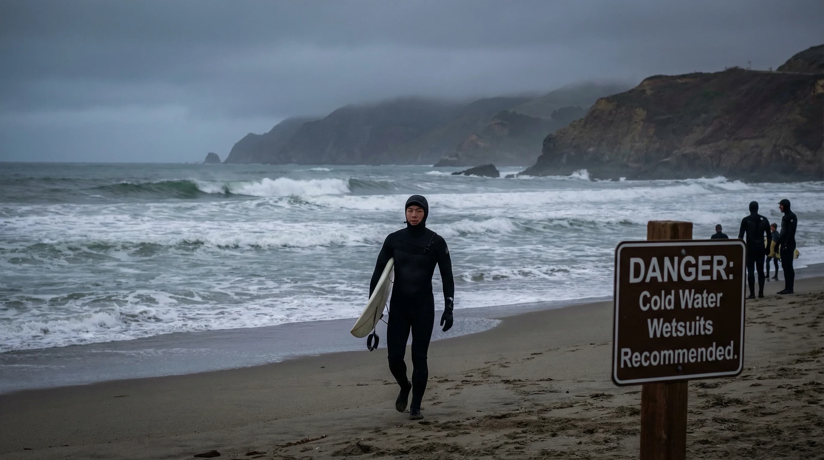
Thermal protection is common for Bay Area surfing and open-water swimming, but wetsuit thickness depends on the measured water temperature, activity, duration, and personal tolerance. Experienced Bay swimmers sometimes swim without a wetsuit; that does not make it a suitable choice for an unprepared visitor. Follow local lifeguard guidance, swimming-club advice, water-quality notices, and beach rules. A wetsuit does not make Ocean Beach safe for swimming or protect against strong currents.
Before a visit, combine these water readings with your destination's air forecast and our Bay Area beach-day planning guide. Keep local advisories and actual conditions ahead of a temperature number.