San Francisco's summer fog is not simply weather. It is the end product of a chain of ocean physics that begins thousands of miles north in the Gulf of Alaska and terminates as gray marine air rolling through the Golden Gate on a July afternoon. The California Current, the coastal upwelling it drives, and the sea surface temperatures it produces are the foundational cause of the Bay Area's fog season. That chain of cause and effect is why the Bay Area's summer weather is what it is, and why these fundamental patterns have persisted for thousands of years.
What Is the California Current?
The California Current is a large-scale ocean circulation system that runs southward along the West Coast of North America, from the Gulf of Alaska down to Baja California. It is part of the North Pacific Gyre, a massive clockwise circulation pattern driven by global wind systems and the rotation of the Earth. The California Current carries cold subarctic water from the north into the mid-latitude Pacific, where it runs adjacent to the California coast.
The current's temperature matters enormously. Water that has traveled south from the Gulf of Alaska is cold, typically running 50 to 58 degrees Fahrenheit off the Northern California coast in summer. This is colder than the air that moves over it, and when relatively warm, moist air passes over that cold ocean surface, the air cools from below. When it cools to the dew point, moisture condenses and the marine layer forms. The California Current does not directly produce fog, but it produces the cold ocean surface that is the necessary precondition for everything that follows.
How Upwelling Makes the Water Even Colder
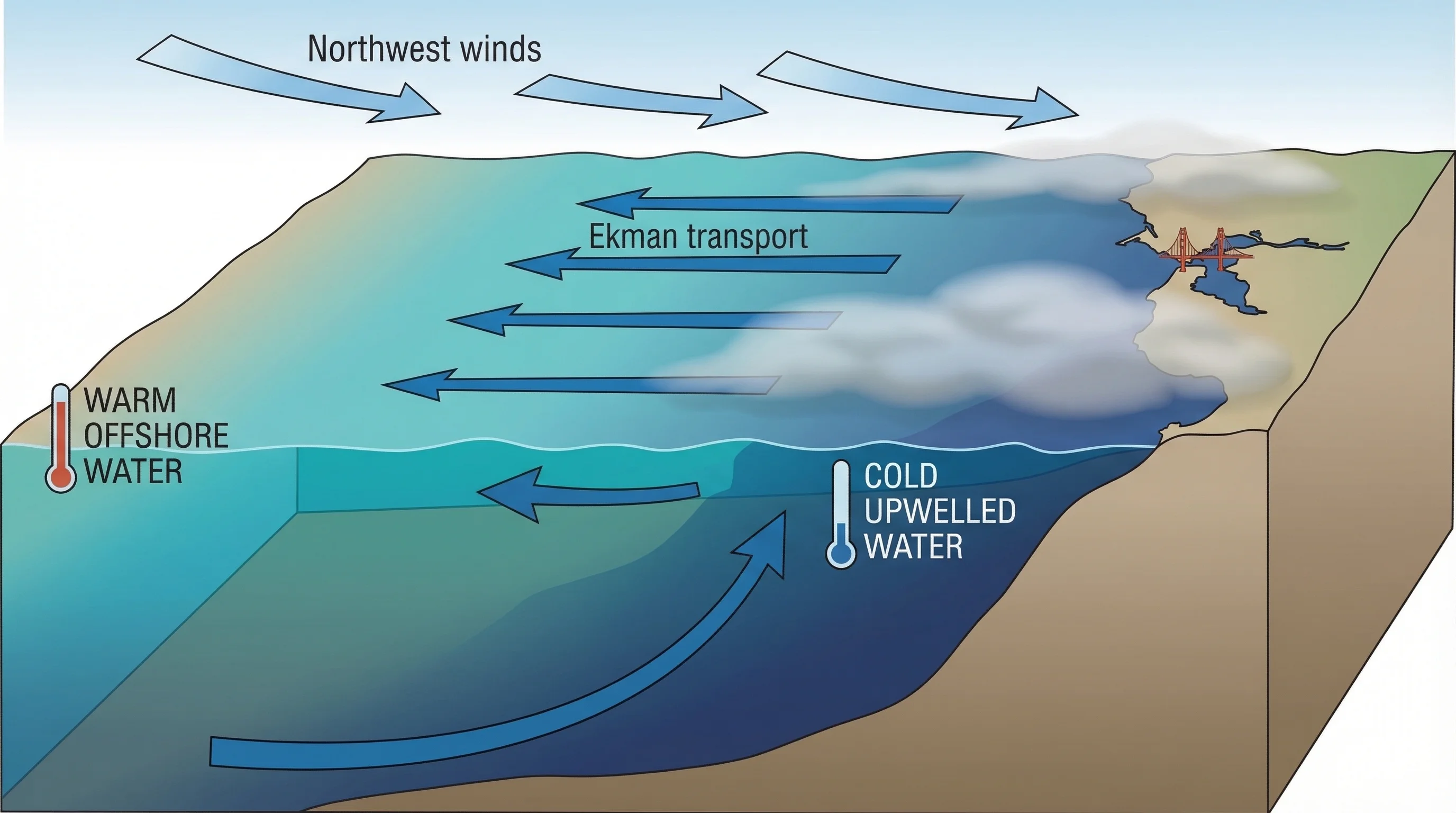
The California Current alone would not create conditions as extreme as those off the Bay Area coast in summer. The additional driver is coastal upwelling. Northwest winds driven by the North Pacific High blow persistently along the California coast from May through September. These winds push the surface ocean water offshore through a process called Ekman transport, in which the Coriolis effect deflects moving water roughly 90 degrees to the right of the wind direction in the Northern Hemisphere. Northwest wind pushes surface water westward and offshore.
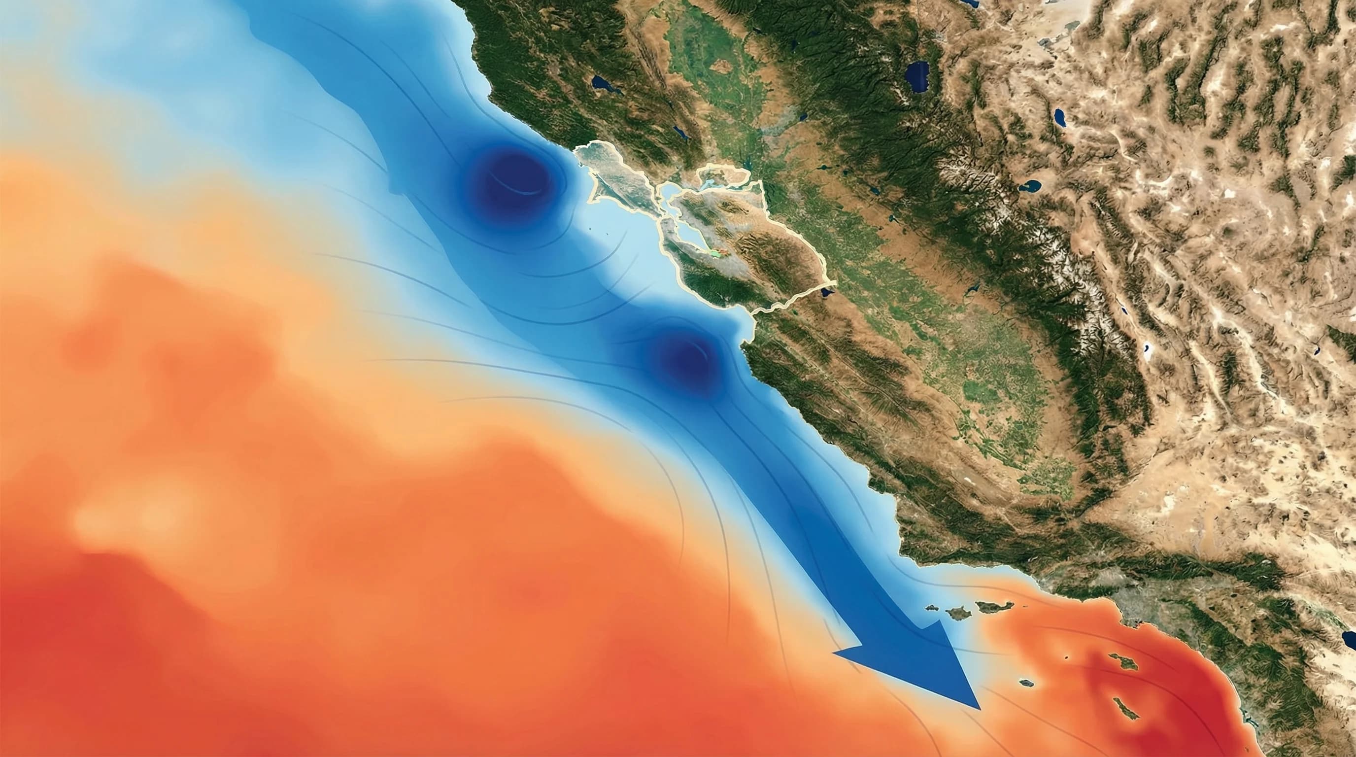
When surface water is pushed away from the coast, something has to replace it. Cold water from depths of 200 to 600 feet rises to fill the void. This upwelled water is not just cold; it is colder than the California Current water above it. Sea surface temperatures in active upwelling zones along the Bay Area coast can run 48 to 52 degrees Fahrenheit, which is cold enough that even on an 80-degree inland afternoon, the ocean air over these waters is chilled to below 60 degrees and often pushed below its dew point, triggering persistent fog formation.
The Bay Area is situated at one of the most productive upwelling zones on the California coast. Point Reyes and Point Arena to the north create strong upwelling signatures. The geography of the Northern California coastline, which runs roughly north-south and faces directly into the northwest winds, maximizes the efficiency of upwelling. This is why the Bay Area's immediate coast is more fog-prone than coastal areas to the south, where the coastline curves and northwest winds are less perpendicular to the coast.
Why the Bay Itself Changes the Picture
The Pacific Ocean's cold water reaches the Bay Area's coast, but it does not directly enter San Francisco Bay in significant quantities. The bay's water is warmer than the open ocean, moderated by tidal mixing, freshwater inflow from rivers like the Sacramento, and the shallower depth that allows solar heating. Bay water in summer typically runs 58 to 65 degrees, noticeably warmer than the 50 to 52-degree ocean temperatures just outside the Golden Gate.
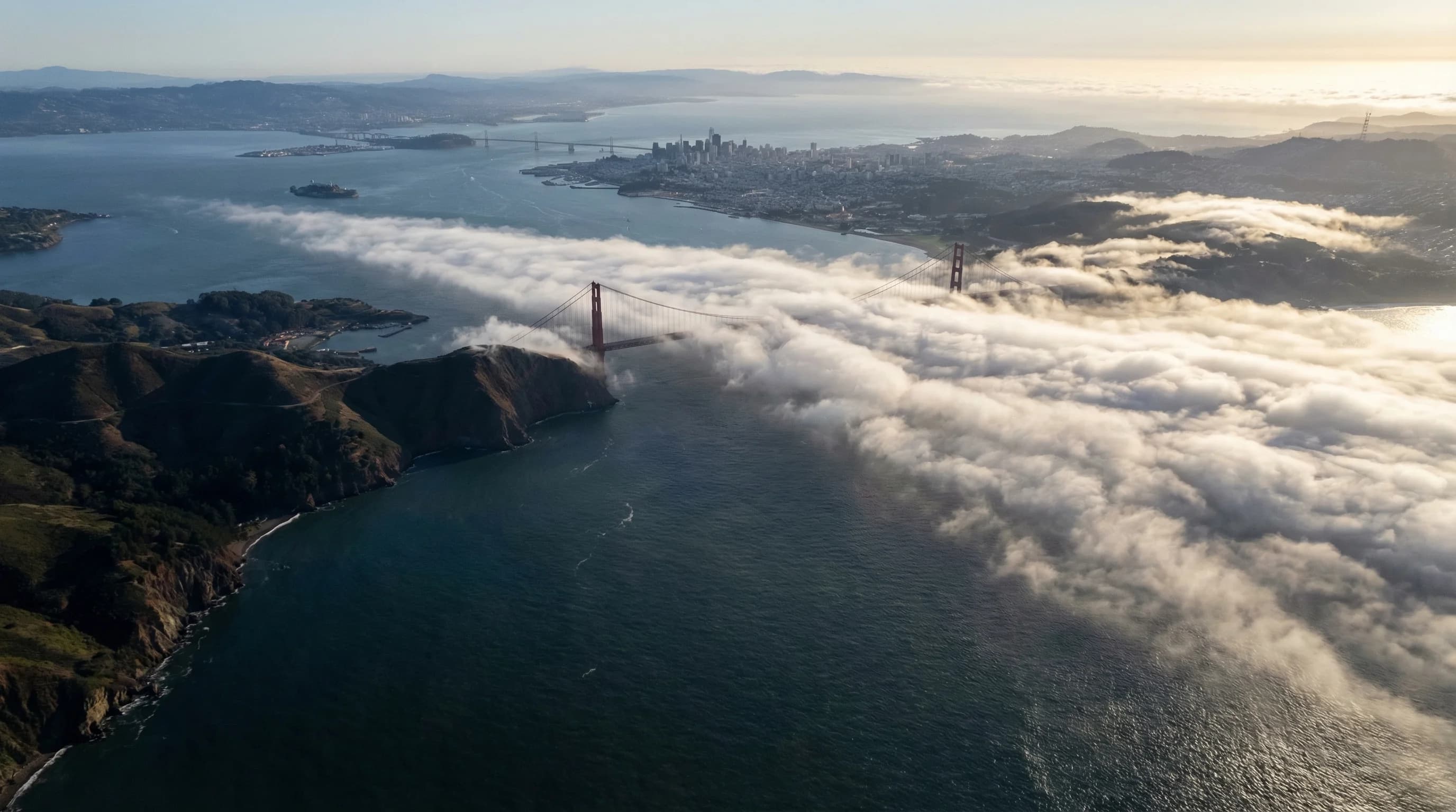
This means the fog that forms over the cold Pacific does not form spontaneously over the bay itself. Instead, it forms over the open ocean and is then pushed inland by the pressure gradient between the cool coast and the hot interior. The Golden Gate is the critical chokepoint: a gap in the coastal mountains that allows the marine layer to pour into the bay basin like water through a funnel. The direction of the Golden Gate, oriented roughly east-west, aligns almost perfectly with the prevailing marine air flow, maximizing the fog intrusion into the bay and the communities surrounding it.
How Cold Ocean Water Drives the Afternoon Fog Push
The mechanism connecting cold ocean water to afternoon fog in the Bay Area operates through pressure and temperature. California's Central Valley heats dramatically each summer afternoon, regularly reaching 95 to 105 degrees in June through September. As the land surface heats, air expands and rises, creating a thermal low-pressure zone over the interior. The cool, heavy marine air over the cold Pacific sits under higher pressure. Pressure gradients drive air from high to low pressure, so marine air rushes inland through the Golden Gate and coastal mountain gaps.
The colder the ocean, the more powerful this mechanism becomes. When upwelling is intense and sea surface temperatures are at their lowest, the contrast between cool marine air and hot inland air is greatest, and the pressure gradient driving the fog inland is strongest. This is why the foggiest days in San Francisco often coincide with the hottest days in Livermore and the Central Valley. The inland heat is the pump, and the cold Pacific is the reservoir.
This relationship means that climate patterns affecting the North Pacific can affect Bay Area fog directly. El Niño years, when the California Current weakens and sea surface temperatures rise, tend to produce less summer fog than La Niña years, when the current strengthens and coastal upwelling intensifies. Long-term trends in North Pacific sea surface temperatures are part of why some scientists have observed changes in Bay Area fog frequency over recent decades.
Why the Coast Never Really Warms Up
One of the most counterintuitive aspects of Bay Area oceanography is that the ocean does not warm significantly during summer. In most parts of the world, ocean surface temperatures peak in late summer because solar heating has been accumulating since spring. Along the Northern California coast, upwelling continually replaces the warming surface water with cold deep water, preventing the gradual seasonal warming that occurs in other regions. Sea surface temperatures off San Francisco in August are often not meaningfully warmer than in May.
This has a direct consequence for fog. In other coastal regions, summer eventually brings warmer water that reduces the temperature contrast driving sea fog. Along the California coast, that contrast remains strong through the summer because upwelling keeps the surface cold. The fog season peaks in July and August not because conditions become less favorable for fog, but because the inland heat is at its maximum and the pressure gradient driving marine air inland is strongest.
The season does shift in September and October. By fall, the North Pacific High weakens, northwest winds diminish, upwelling slows, and for the first time since spring, the ocean surface can warm slightly. This is why September and October produce the Bay Area's clearest and warmest coastal weather: inland temperatures moderate, the pressure gradient weakens, and the cold water engine that drives the marine layer fog slows down. For anyone wanting to experience the Bay Area coast in actual warmth, these two months are the payoff for surviving the summer fog season.