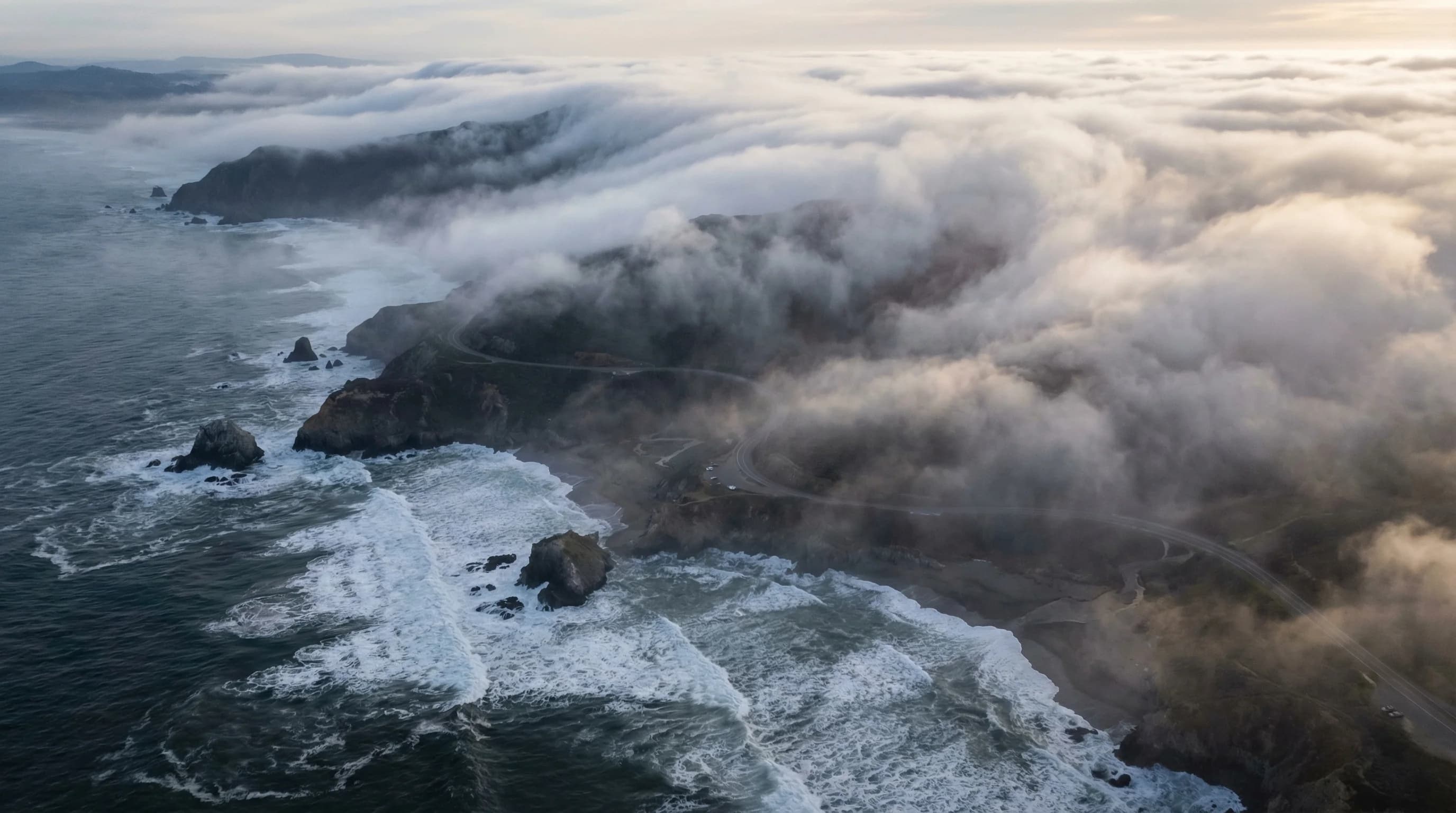
The fog that blankets the Northern California coast from May through September is not random weather. It is the predictable result of three physical forces operating in concert: cold ocean water, strong summer winds, and a thermal pressure gradient that pulls marine air inland every afternoon. The coast from Bodega Bay north through Mendocino and Humboldt is one of the foggiest stretches of shoreline in the lower 48 states, and the reason it is foggier than the coast to the south comes down to geography and oceanography working together in almost perfect fog-producing alignment.
Why Is the Northern California Coast So Cold?
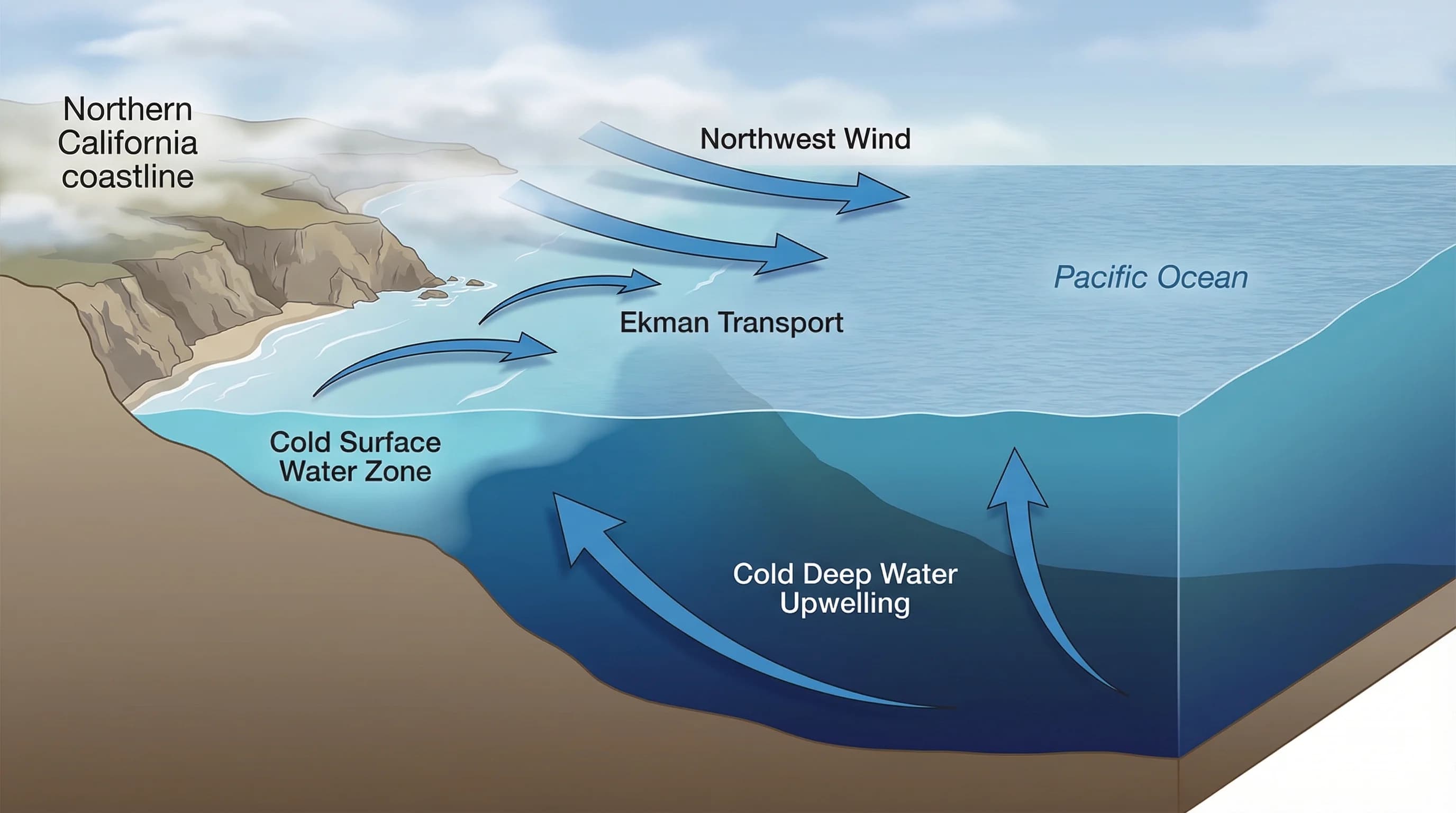
The Pacific Ocean off Northern California is dramatically colder than you would expect for a coast at this latitude. Los Angeles sits further south and has warmer water. San Diego is warmer still. Northern California, despite being in the same general latitude as Spain and southern France, has ocean water that runs between 48 and 54 degrees Fahrenheit in summer. The reason is coastal upwelling.
California sits along the eastern edge of the North Pacific High, a massive semi-permanent high-pressure system. In summer, this system generates persistent northwest winds that blow along the California coast from roughly May through September. When wind blows parallel to a coastline in the Northern Hemisphere, the Coriolis effect pushes surface water offshore at roughly a 90-degree angle to the wind. This is Ekman transport: northwest winds along the coast push surface water westward and offshore, drawing cold water up from depth to replace it. That cold upwelled water is not just cooler than the atmosphere above it; it is cold enough to chill the air that sits over it to below the dew point, triggering condensation and fog formation.
How the Fog Actually Forms: Cold Water, Warm Air, and the Inversion
Once cold water is at the surface, fog formation follows a consistent pattern. The air mass moving inland from the Pacific is relatively warm at altitude, but as it passes over the cold upwelled water, the lowest layer of air cools rapidly. When that air cools below its dew point, the water vapor it carries condenses into tiny water droplets suspended in the air. This is advection fog: fog formed when warm, moist air moves over a cold surface.
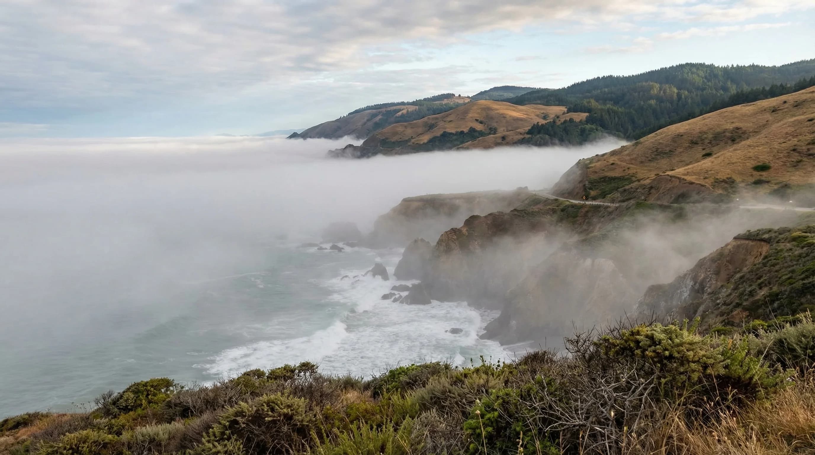
The marine layer that results from this process sits in a defined band, typically between the ocean surface and 1,000 to 2,000 feet altitude, with a strong temperature inversion capping it. Below the inversion, the air is cool, moist, and often foggy. Above the inversion, the air warms rapidly and skies are clear. This is why you can sometimes drive up a coastal mountain road and emerge from gray, 50-degree marine air into bright warm sunshine within a few hundred feet of elevation gain. The inversion is a physical ceiling that traps the fog layer below it.
Northern California's coast is particularly susceptible to this because the upwelling zone here is exceptionally strong. The combination of the Point Conception geography to the south (which deflects the California Current), the consistent northwest winds, and the offshore bathymetry creates some of the most vigorous upwelling on the West Coast. Sea surface temperatures around Bodega Bay and Point Arena routinely run 5 to 10 degrees colder than San Diego in summer, a counterintuitive result given that upwelling, not latitude alone, drives the temperature difference.
Why the Fog Moves Inland: The Thermal Low
Cold ocean water and fog over the coast would not matter much if the fog just stayed put. What makes Northern California's fog pattern relevant to inland communities, and what drives the afternoon fog push into places like Petaluma, Santa Rosa, and the Sonoma Valley, is a pressure gradient created by inland heating.
California's Central Valley heats up dramatically on summer afternoons. As the land surface heats and air expands and rises, it creates a thermal low-pressure zone over the interior. Meanwhile, the high pressure associated with the cold coastal ocean remains strong and relatively stable. This pressure difference is the engine that pulls marine air, and the fog layer it contains, inland through coastal gaps and river valleys. The stronger the inland heating, the stronger the pressure gradient, and the further inland the fog pushes.
This is why fog behavior along the Northern California coast is predictably tied to inland temperatures. On days when the Central Valley reaches 100 degrees or above, the fog push inland is dramatic: the marine layer can pour through the Petaluma Gap, flood the Sonoma Valley, and push well into wine country. On cooler summer days when the inland low is weaker, the fog may hug the immediate coast and retreat by midday. The same mechanism that creates San Francisco's famous afternoon fog machine operates at greater scale all the way up the Northern California coast.
Why Summer Is Foggy and Winter Is Not
The fog season along the Northern California coast runs roughly May through September, with July and August being the peak months. This pattern reverses what people from other regions intuitively expect: summer should be sunny and warm, and winter should be gray and wet. Along the Northern California coast, summer is gray and foggy, while winter brings rain but far less persistent low cloud cover.
The reason comes back to the North Pacific High. In summer, this high-pressure system is positioned and strengthened in a way that drives intense upwelling along the California coast, generating the cold water that produces fog. In winter, the high weakens and shifts south, upwelling decreases, and the coast is instead dominated by storm systems tracking down from the Gulf of Alaska. Winter storms bring rain and wind, but not the persistent advection fog that characterizes summer. The marine layer does exist in winter, but it is thicker, rainier, and moves differently than the summer fog pattern.
The practical implication for anyone planning visits to the Northern California coast is that August is one of the foggiest months, not one of the sunniest. September and October are often significantly clearer than July and August because the North Pacific High begins to weaken, upwelling declines, and the coast catches more days of warmth before the winter rain season begins. If you want sunny days at Bodega Bay, Jenner, or Fort Bragg, September and October are historically the best bets.
How Northern California Fog Differs from San Francisco Fog
The fog north of San Francisco along the Sonoma, Mendocino, and Humboldt coasts shares the same basic mechanism as the Bay Area marine layer, but it behaves differently in important ways. Bay Area fog is largely organized around the geography of the bay: it enters through the Golden Gate and specific mountain gaps, creates the famous microclimate divisions between foggy coast and sunny inland, and tends to have reliable morning burn-off patterns depending on location.
Fog along the North Coast is more persistent and less mediated by a complex inland basin. There is no bay to organize the marine air and no East Bay hills to block it at a certain elevation. The fog here sits directly on the coast and moves inland along river valleys, particularly the Russian River and Eel River corridors. Communities like Guerneville and Monte Rio, 15 miles inland up the Russian River from the coast, receive fog regularly because the valley funnels marine air directly from the coast.
For Bay Area residents, the Northern California coast offers a specific kind of summer trip: you can expect it to be cool, often overcast, and dramatically different from a hot inland valley day. That consistent summer fog is why the redwood forests of Humboldt County exist: the trees depend on the moisture from summer fog drip as much as they depend on winter rainfall. The fog that frustrates visitors looking for beach weather is the same system that sustains one of the world's most remarkable forests.