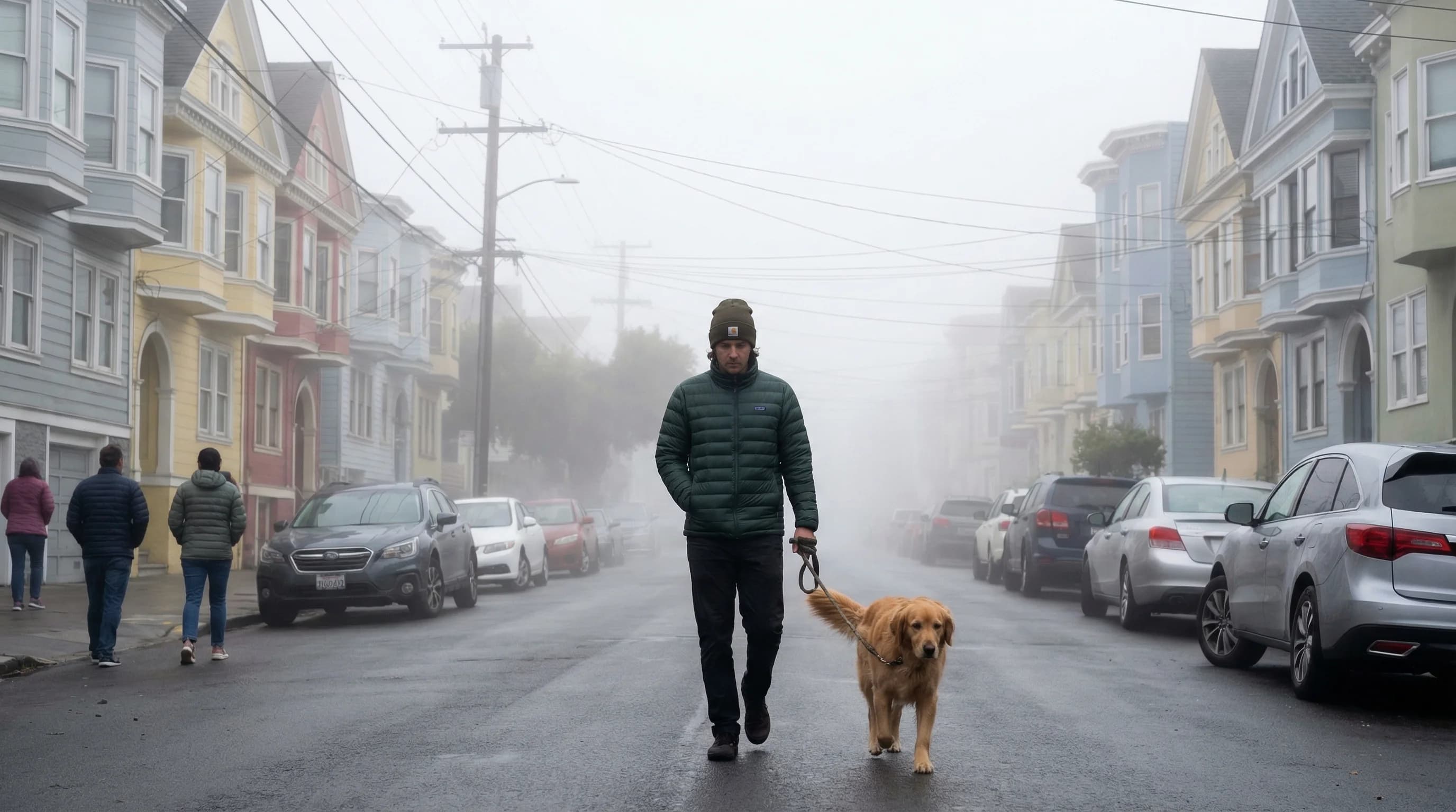
Advection fog is the fog that defines the Bay Area's summer identity. It is the fog that rolls through the Golden Gate in the afternoon, fills the Sunset District overnight, and burns off reluctantly by mid-morning. Unlike radiation fog, which forms in place over cooling ground, advection fog forms over the cold Pacific Ocean and is carried inland by wind. It is the product of warm, moist air moving horizontally over a cold surface and being chilled from below until condensation occurs. In the Bay Area, that cold surface is the California Current, one of the coldest stretches of ocean water on the Pacific Coast.
How Advection Fog Forms
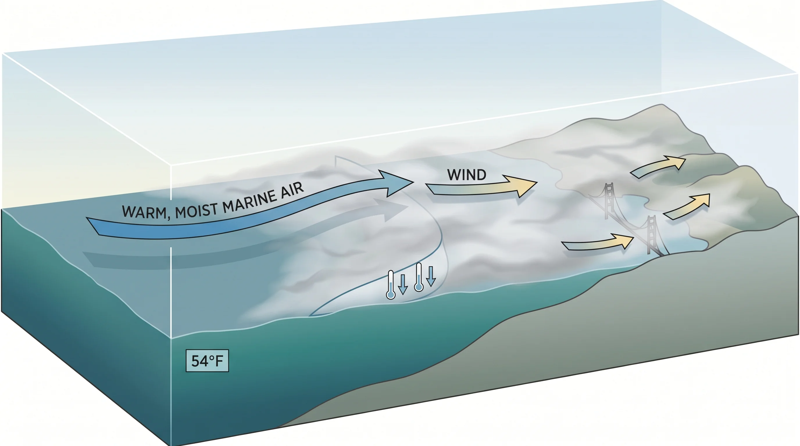
The word advection describes horizontal movement of air, as opposed to convection, which describes vertical movement. Advection fog forms when a mass of relatively warm, humid air travels over a surface cold enough to chill it below its dew point. As the air cools, it can no longer hold all its water vapor, and the excess condenses into fog droplets suspended near the surface.
In the Bay Area, the setup is nearly ideal for advection fog every summer. The North Pacific High, a persistent high-pressure system sitting offshore, drives surface winds southward along the California coast. These winds push surface water offshore, drawing cold, deep ocean water toward the surface through a process called upwelling. The result is sea surface temperatures off San Francisco that often sit in the low to mid-50s Fahrenheit even in July, while air temperatures a few hundred feet above the ocean may be in the 60s or 70s. When summer air masses flow over this cold strip of water, they cool rapidly from the bottom up. The fog that forms is dense, low, and extensive, covering much of the immediate coast.
What moves advection fog inland is the same pressure gradient responsible for the Bay Area's famous afternoon wind. Hot inland temperatures in the Central Valley and the interior valleys create a strong low-pressure zone. Cool, high-pressure air from the ocean flows toward it, carrying the fog bank with it. The Golden Gate is essentially a funnel that channels this flow directly into the city.
Advection Fog vs. Radiation Fog
The distinction matters for predicting fog behavior. Advection fog and radiation fog look similar from the street, but they come from entirely different atmospheric processes and behave differently as a result.
Radiation fog forms on calm, clear nights over land as the ground loses heat. It thickens through the night, peaks around dawn, and burns off predictably as the sun heats the surface. You find it in valley bottoms and flat inland areas: the Napa Valley, the Livermore Valley, the Petaluma lowlands. Advection fog forms over the ocean and moves with the wind. It arrives not at 3 a.m. but in the afternoon or evening, driven by onshore flow. It does not clear with sunrise alone because it is continuously replenished from the ocean; it clears only when the pressure gradient weakens and the onshore flow slows.
This is why San Francisco's summer fog is so persistent. On days when the pressure gradient is strong, the fog pours in all day and night. On days when it relaxes, the fog burns off by noon. Radiation fog in Napa, by contrast, nearly always clears by mid-morning regardless of the season, because it depends only on local solar heating.
Where Advection Fog Is Strongest in the Bay Area
Advection fog is most intense closest to the ocean and the gaps that let it through. The Outer Sunset and Outer Richmond in San Francisco are the Bay Area's advection fog capitals: they sit directly in the path of the marine layer flowing in from the Pacific, and they are low enough that the fog rarely rises above them. On a typical summer day, these neighborhoods spend eight to twelve hours in thick fog.
The fog thins as it moves inland and encounters warmer surfaces that heat it from below. By the time it reaches the Mission District, two to three miles east of the Outer Sunset, it has often thinned to a high overcast or burned off entirely. Neighborhoods elevated above the fog layer, such as Twin Peaks and Diamond Heights, may be in clear air while the neighborhoods immediately below them are socked in. This produces the Bay Area's characteristic fog line, the sharp boundary visible on the hills where gray fog gives way abruptly to blue sky.
Beyond the city, advection fog reaches as far inland as the pressure gradient can carry it. On strong marine push days, it flows through the Delta and reaches Sacramento. On weak days, it barely makes it past the immediate coast. The variability is daily and sometimes hourly, which is why Bay Area fog forecasting is genuinely difficult even with modern atmospheric modeling.
Advection Fog and the Bay Area Summer Experience
Advection fog is the reason San Francisco's summer feels so different from nearly every other city in America. While the interior of California bakes in triple-digit heat, the city sits under a marine layer that keeps afternoon temperatures in the low to mid-60s. The fog is the Bay Area's natural air conditioning, and its variability across short distances is the source of the region's famous microclimate diversity.
For residents and visitors, understanding that the city's fog is advection fog has practical implications. It means that checking whether the offshore pressure gradient is strong is more useful than checking whether it rained last night. It means that neighborhoods west of Twin Peaks are reliably foggier than neighborhoods east of it. And it means that Livermore and Walnut Creek, just 30 miles inland, may be 30 to 40 degrees warmer on the same afternoon that the Ocean Beach area is wrapped in gray. Advection fog is not random. It is systematic, driven by ocean temperature and pressure physics, and once you understand the mechanism, the Bay Area's fog patterns become entirely predictable.