Geography is destiny in the Bay Area, and nowhere is that more obvious than in the contrast between San Francisco and Oakland. They are ten miles apart. They share the same bay, the same general latitude, the same summer calendar. But on a July morning when San Francisco's Outer Sunset sits at 62 degrees under a low gray ceiling, Oakland is often running at 80 degrees and sunny. This is not a minor variation. It is a fundamentally different summer experience driven by physical geography that does not change from year to year. If you want to understand Bay Area weather, you need to understand why these two cities live in different climates despite being neighbors.
The Golden Gate Funnel Effect
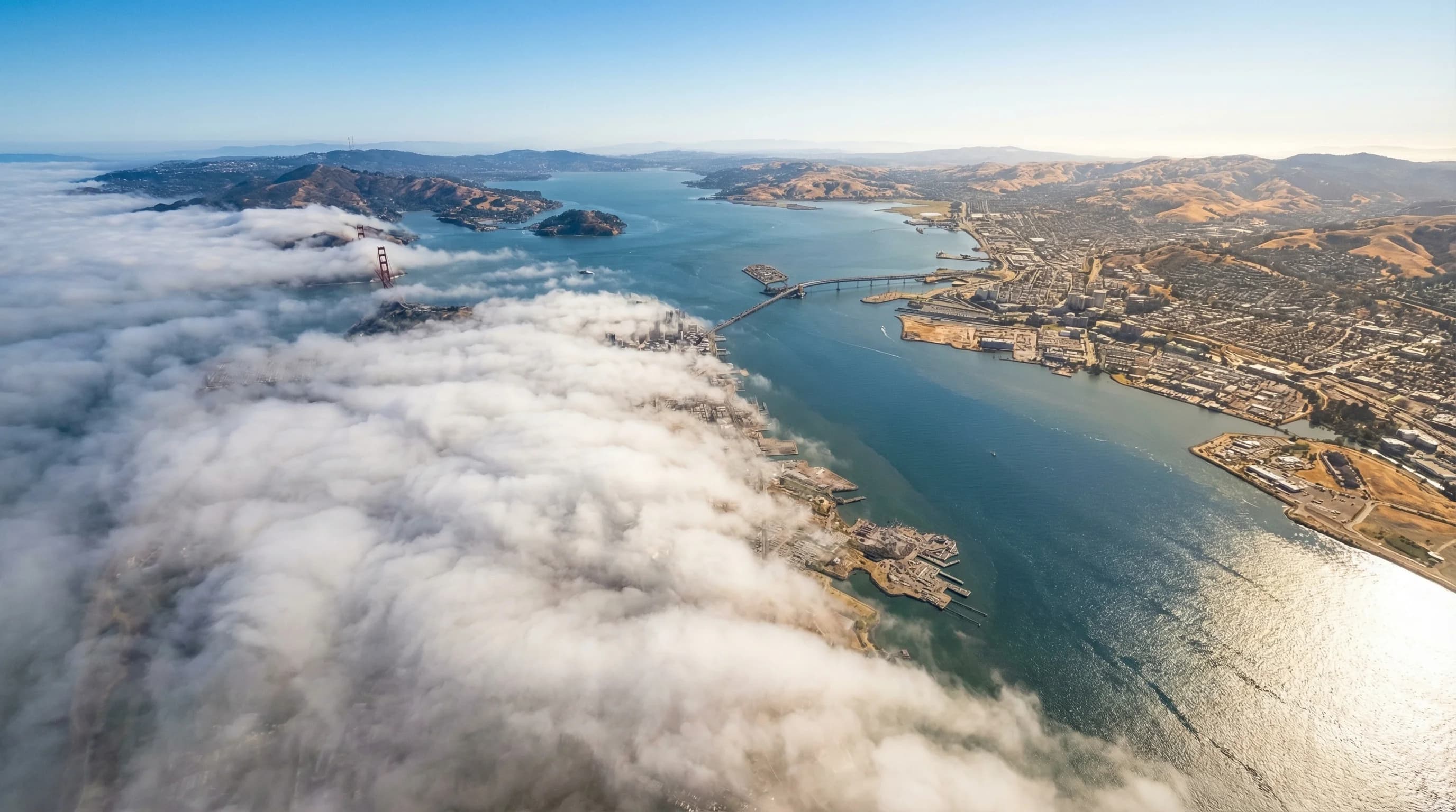
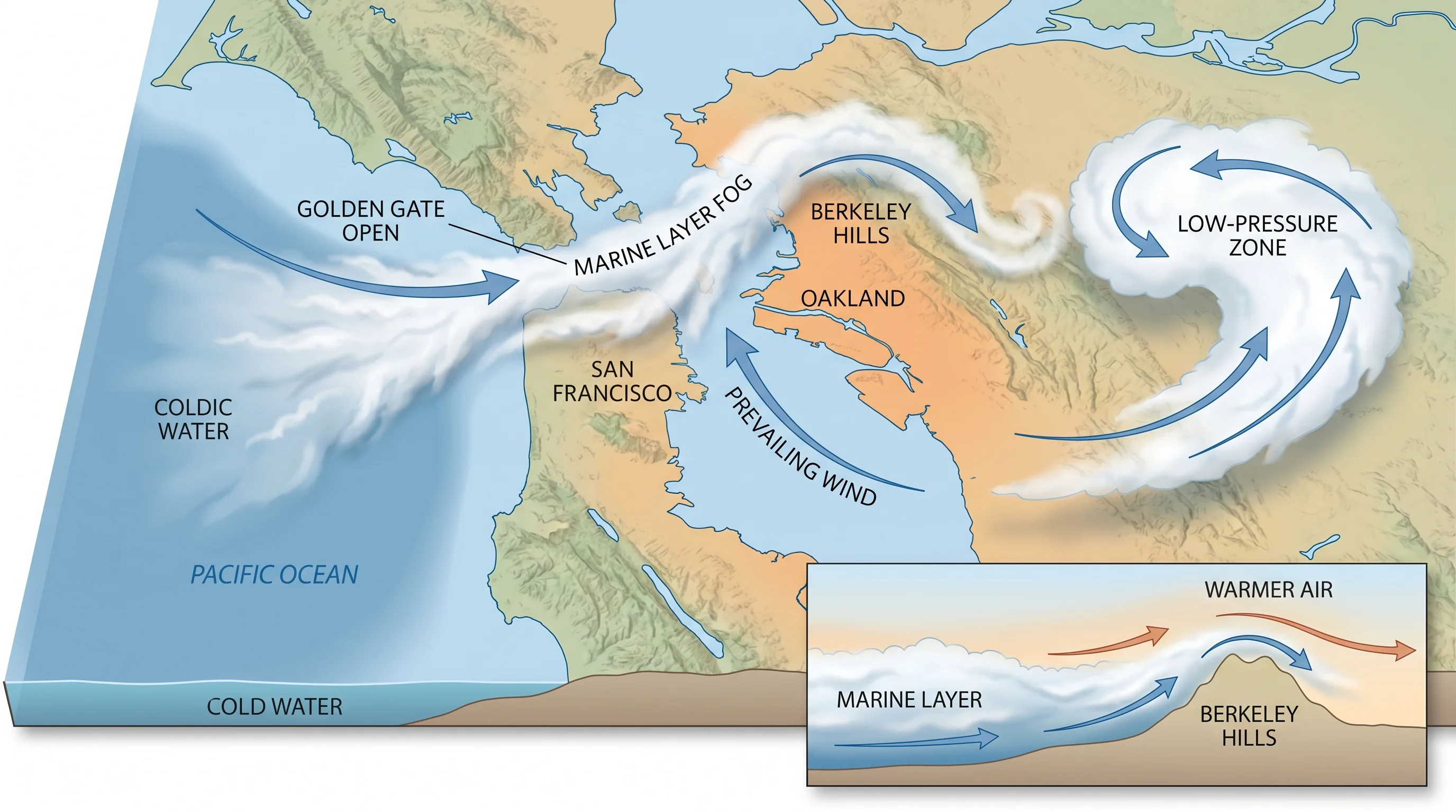
San Francisco is surrounded by ocean on three sides. The Pacific lies to the west along Ocean Beach. The bay wraps around to the north and east. The city sits on a peninsula with essentially no inland buffer on its windward face. The Golden Gate, the strait connecting the Pacific to the bay, is the largest sea-level gap in the coastal mountains for hundreds of miles. Every summer afternoon, when the Central Valley heats up and drops in pressure, cold marine air is pulled through that gap with considerable force.
The gap acts as a funnel. Marine air that would otherwise spread broadly along the coast gets concentrated through this narrow opening, then fans out across the northern city neighborhoods. The Marina, the Richmond, the Outer Sunset, and the Sunset district receive the brunt of this flow. Wind speeds through the Golden Gate regularly hit 25 to 35 miles per hour on summer afternoons, carrying fog with them. San Francisco is not just near the coast; it is positioned directly in the path of the most efficient marine air delivery mechanism on the California coastline.
The Thermal Pressure Gradient
The mechanism driving the fog is temperature difference. California\'s Central Valley runs 95 to 105 degrees on summer afternoons, creating low pressure over the hot interior. The Pacific Ocean surface, kept at 55 to 58 degrees year-round by cold upwelling and the southward-flowing California Current, maintains high pressure offshore. Cold, dense air flows toward warm, low-pressure air. The Bay Area coastline is where these two air masses collide.
San Francisco sits right at the mouth of this collision zone. Oakland sits behind a buffer zone, separated from the Pacific by miles of bay water, the East Bay hills, and the accumulating warmth of the land between. By the time marine air reaches Oakland, it has already traveled across the bay, lost some of its chilling effect over the warmer water, and climbed or been blocked by the terrain. The gradient that drives fog into San Francisco at full strength has already spent much of its energy before it gets to Oakland.
The Berkeley Hills as a Wall
The Berkeley Hills are not dramatic by mountain standards, topping out above 1,700 feet at peaks like Grizzly Peak (1,754 feet), but they do not need to be dramatic to work as a fog barrier. The marine layer that floods San Francisco typically runs 300 to 800 feet thick. A ridge that rises above 1,000 feet is more than enough to block the bulk of that layer from pushing eastward. The hills act as a physical wall, and the communities on their eastern slopes, Orinda, Moraga, Lafayette, live in a genuinely different climate from communities five miles to their west.
Berkeley itself sits at the base of the western slope and occupies a middle position. The hills protect it from the deepest fog intrusions, and marine air that clears the ridge often warms enough through compression to arrive as merely cool air rather than cold fog. Berkeley tends to be warmer and sunnier than San Francisco while still being significantly cooler than the communities directly behind the ridge crest. It is a microclimatic sweet spot that Berkeley residents are entirely aware of.
What the Temperature Data Actually Shows
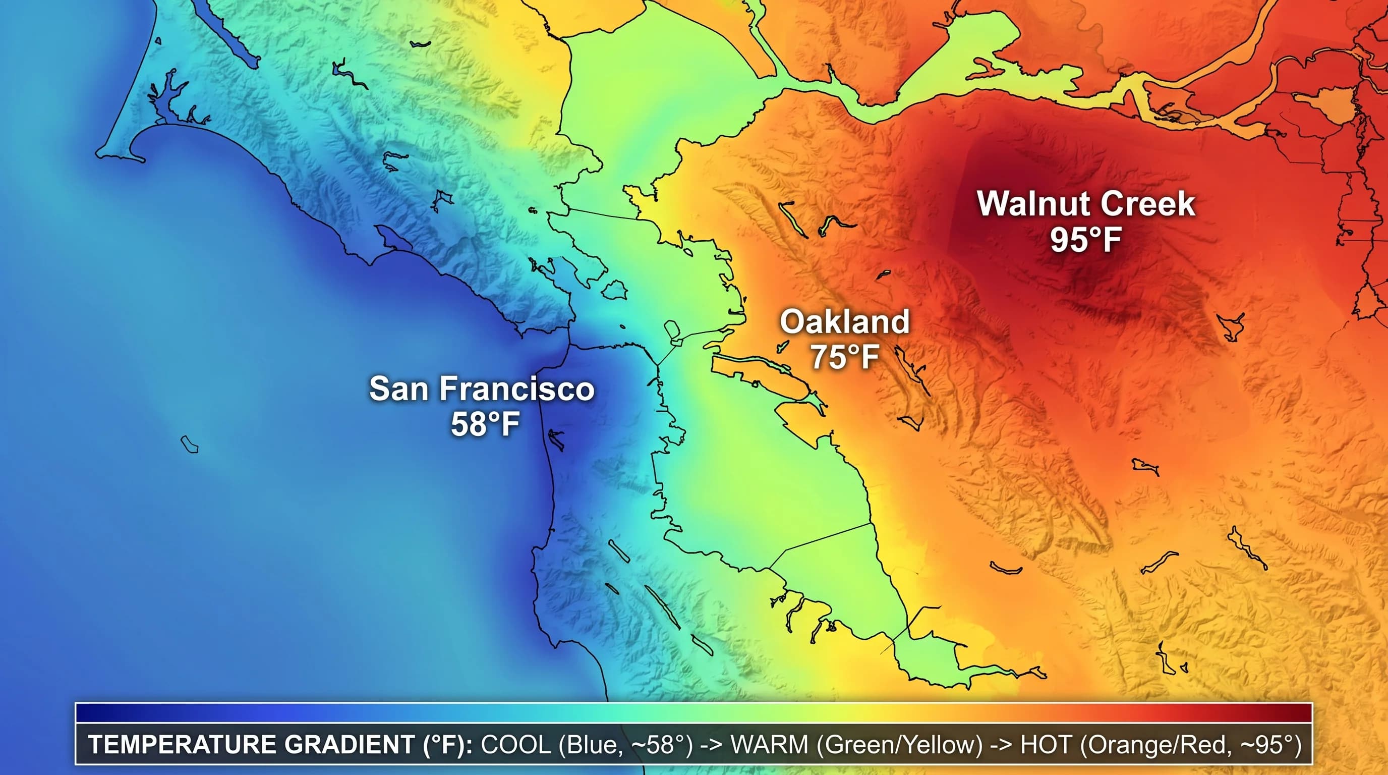
In summer, San Francisco averages around 65 degrees Fahrenheit. Oakland averages 75 to 80 degrees during the same months. That gap, 10 to 15 degrees, persists through the entire summer season and is not a product of unusual weather events. It is the baseline. On the hottest inland days, when the pressure gradient is strongest and the marine layer most aggressive, the contrast sharpens further. Walnut Creek, another 15 miles east of Oakland, regularly hits 85 to 90 degrees on days when San Francisco is at 62. That is a 25-degree spread across roughly 30 miles, driven entirely by geography.
These are not cherry-picked examples. NOAA climate data for Bay Area stations shows this pattern holding across decades of records. The gradient is real, consistent, and predictable. Anyone telling you Bay Area weather is unpredictable is usually talking about the unpredictability of any given day's fog timing, not the underlying climate pattern, which is quite predictable once you understand the terrain.
Variation Within San Francisco Itself
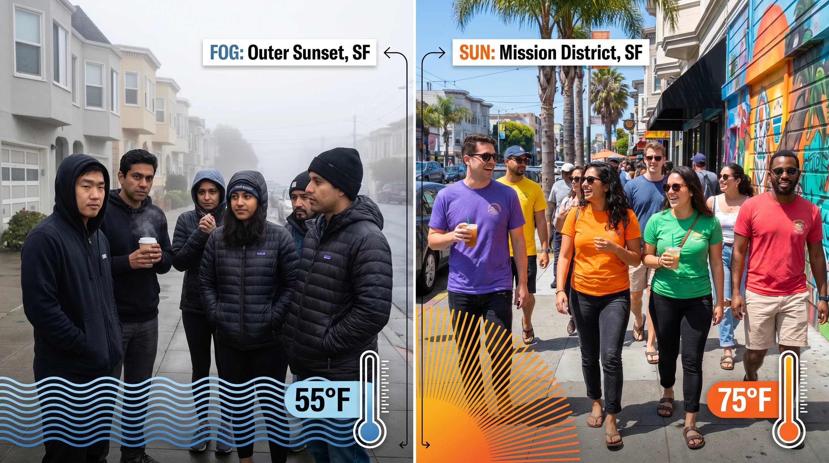
San Francisco is not uniformly foggy. The city has its own internal geography that creates meaningful temperature differences across just a few miles. The Outer Sunset, facing directly west toward the Pacific, typically sits at 62 degrees on a foggy July day. The Mission District, sheltered by the hills and sitting in a thermal pocket on the eastern side of the city, often hits 72 degrees on the same day. That's a 10-degree difference within a single city.
Elevation matters enormously here. Twin Peaks rises to 922 feet, well above the typical marine layer ceiling of 300 to 800 feet. On days when fog sits thick below, the summit of Twin Peaks is often in clear sunshine with views over the cloud deck. This is why neighborhoods clustered at elevation, like the Castro, Noe Valley, and the upper slopes near Diamond Heights, see meaningfully less fog than the flat western neighborhoods. Every 100 feet of elevation is roughly 1.5 to 2 degrees warmer when you are poking through a fog layer.
Escape Routes from the Fog
If you are in San Francisco on a foggy summer day and want sun, the options are clear. Crossing the Bay Bridge to Oakland takes 15 minutes and often gains you 15 degrees. Driving into Berkeley puts you at the edge of the fog zone, usually in partly sunny conditions. Going through the Caldecott Tunnel into Orinda is like passing through a weather portal: gray and cool on the west side, warm and clear on the east. Walnut Creek and the Lamorinda communities behind the hills consistently deliver the warmth that the San Francisco summer famously withholds.
The escape routes are not complicated. The principle is simple: go east and go inland. The marine layer has limits, and the Berkeley Hills mark roughly where those limits end. The Bay Area is not one climate but several, stacked tightly against each other in a way that has no real parallel anywhere else in the country.
Why This Matters for Anyone Living Here
Bay Area real estate prices reflect these climate differences in ways that are easy to overlook. A house in the Outer Sunset with ocean views costs less per square foot than comparable homes in Noe Valley or the Mission, partly because buyers who have lived here long enough know what the Outer Sunset summer feels like. Fog-free neighborhoods carry genuine premiums. People who prioritize sun when choosing where to live end up in the East Bay or the south bay rather than the west side of San Francisco, and they are not wrong to make that choice.
For visitors, the calculus is simpler. If you want to experience San Francisco's particular cool, atmospheric summer, the western neighborhoods are authentic and beautiful. If you want sun and warmth while day-tripping, build Oakland or Berkeley into your itinerary and accept that the bridge crossing will feel like a brief journey between weather systems. Because it is.