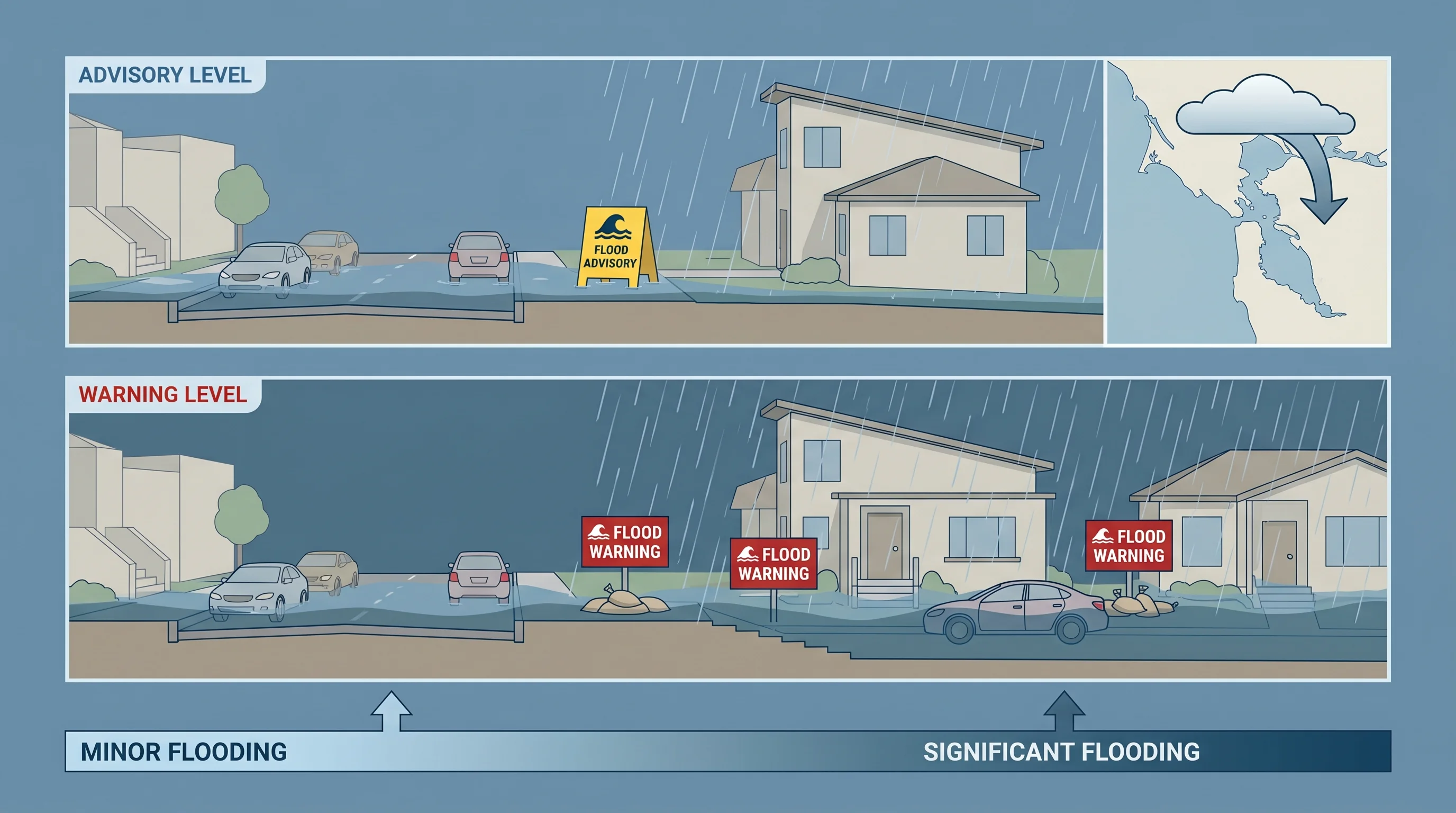
A flood advisory means minor flooding is occurring or expected, and you should stay aware. A flood warning means significant flooding is occurring or imminent, and you need to take protective action immediately. A flood watch means conditions are favorable for flooding, but it has not started yet. These three alert levels, issued by the National Weather Service office in Monterey (which covers the Bay Area), represent a clear escalation of urgency, and understanding the difference between them is essential for anyone living in the Bay Area's flood-prone areas.
What Does Each Flood Alert Level Mean?
The NWS uses a three-tier system for inland flooding that mirrors its structure for other hazards like coastal flood alerts. A flood watch is the earliest signal: it means hydrometeorological conditions are favorable for flooding within the next 12 to 48 hours, but the event has not begun. In the Bay Area, a flood watch is typically issued before a major atmospheric river makes landfall, when forecast models show heavy rainfall targeting the region but exact totals and timing still carry uncertainty. The watch is your window to prepare.
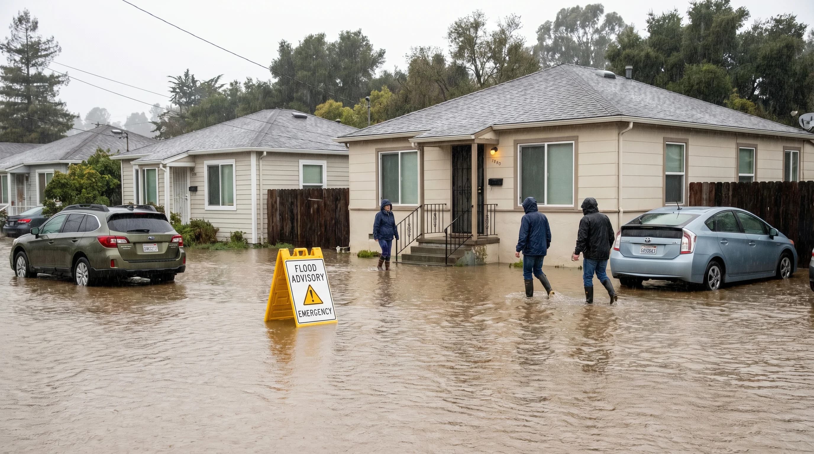
A flood advisory is issued when flooding is occurring or imminent, but the expected impacts are minor: ponding on roads, water in low-lying areas, nuisance-level creek rises. An advisory does not mean the situation is safe to ignore. It means the flooding is not expected to reach life-threatening levels if people exercise normal caution. In the Bay Area, flood advisories are common during the wet season from November through March, especially in urban areas like San Francisco and Oakland where overwhelmed storm drains cause street-level flooding during moderate storms.
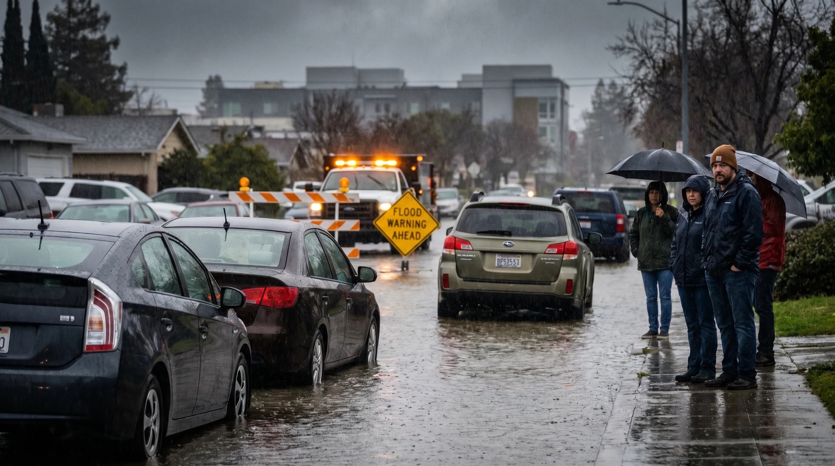
A flood warning is the most urgent alert. It means significant flooding is occurring, imminent, or highly likely. In the Bay Area, a flood warning typically means a creek or river has reached or is expected to reach flood stage, and properties in the floodplain are at risk. The NWS issues flood warnings based on data from USGS stream gauges, which measure water levels in real time on waterways like Coyote Creek in San Jose, the Napa River through Napa, and San Francisquito Creek along the Peninsula. When a flood warning is issued, people in the affected area should be ready to evacuate or move to higher ground.
How Are Flash Flood Warnings Different from River Flood Warnings?
The Bay Area receives two distinct types of flood warnings, and the difference matters for how quickly you need to act. A river flood warning (also called an areal flood warning) is issued when sustained rainfall causes a gradual rise in creek and river levels over hours or days. The January 2017 Coyote Creek flood in San Jose, which forced the evacuation of 14,000 residents, was preceded by river flood warnings as the creek gauge at Edenvale rose steadily over a 48-hour period. You may have hours to respond.
A flash flood warning is fundamentally different. It means flooding is occurring or will occur within minutes to a few hours, typically from intense rainfall overwhelming small creek channels, urban storm drains, or burn scar areas. Flash flood warnings give you minutes, not hours. In the Bay Area, they are most common in the steep terrain of the Santa Cruz Mountains, the Marin headlands, and the East Bay hills, where rainfall rates of 1 to 2 inches per hour on saturated soil can send walls of water down narrow canyons. The extreme single-day rainfall events that produce 5 or more inches in 24 hours are the primary drivers of Bay Area flash flood warnings.
Where Are Flood Alerts Most Common in the Bay Area?
Flood alerts in the Bay Area cluster around specific geographic patterns. The Napa River corridor through downtown Napa is one of the most frequently warned areas, despite the completion of the Napa River flood control project in 2019. Major atmospheric rivers can still push the river above flood stage. Coyote Creek through San Jose, which flooded catastrophically in February 2017, remains a frequent target for flood warnings because the creek runs through densely populated neighborhoods with limited channel capacity. Corte Madera Creek in Marin County, San Francisquito Creek on the Peninsula, and Alameda Creek in the East Bay all have histories of flood warnings during intense winter storms.
Flood advisories, by contrast, are more common in urban flat areas. San Francisco's storm drain system was designed in the early 20th century and struggles with modern rainfall intensities. The Mission District, the Sunset, and SoMa regularly see advisory-level street flooding during moderate to heavy rain. Coastal communities like Pacifica and Half Moon Bay can receive both inland flood advisories from creek drainage and coastal flood alerts from high surf and storm surge simultaneously, which complicates the hazard picture for residents.
How Do You Receive Flood Alerts in the Bay Area?
The most reliable way to receive flood alerts is through Wireless Emergency Alerts (WEA), the system that sends loud, attention-grabbing notifications to every cell phone in a threatened area. Flash flood warnings and flood warnings automatically trigger WEA messages. Flood advisories and watches, because they represent lower urgency, do not always generate WEA alerts, so relying on your phone to buzz is not sufficient for the full picture.
The NWS Bay Area forecast office publishes all watches, advisories, and warnings at weather.gov/mtr. County emergency services, including AlertSCC ( Santa Clara County), AlertMarin, and SF72 (San Francisco), operate opt-in notification systems that provide more granular local detail than federal alerts. NOAA Weather Radio (station KHB49 covers the Bay Area on 162.400 MHz) broadcasts continuous updates during active flood events and is the only alert system that works when cell networks are overloaded or power is out.
For real-time creek and river conditions, the USGS WaterWatch page (waterwatch.usgs.gov) shows current stream gauge readings for every monitored waterway in the Bay Area. The Contra Costa County Flood Control District and Santa Clara Valley Water District also maintain public stream gauge dashboards with near-real-time water level data. During an active atmospheric river, checking the gauge nearest your home is the most direct way to know whether your local creek is approaching flood stage.
What Should You Do at Each Alert Level?
When a flood watch is issued, review your flood zone status and know your evacuation route. Move vehicles away from creek channels and low-lying garages. Charge devices and have a go-bag accessible. If you live along a waterway with a USGS gauge, bookmark the gauge page so you can monitor levels as the storm progresses.
When a flood advisoryis active, avoid driving through standing water. Even six inches of moving water can knock a person down, and 12 inches can carry a vehicle. Stay off roads near creeks and low-water crossings. The flooding is expected to be minor, but "minor" in a flood context still means property damage and road closures are possible.
When a flood warningis issued, take immediate action. If you are in the warned area, be prepared to evacuate. Do not wait for water to reach your door. Flood waters rise faster than most people expect, especially in narrow creek corridors where the Bay Area's topography concentrates runoff. The 2017 Coyote Creek flood in San Jose went from manageable creek levels to neighborhood-scale inundation in roughly six hours. Never attempt to drive or walk through floodwaters. Follow evacuation orders from local emergency services without delay.
The difference between a flood advisory and a flood warning is not academic. It is the difference between inconvenience and emergency, between water on your street and water in your home. The Bay Area's combination of steep terrain, variable rainfall distribution, aging storm drain infrastructure, and dense creek-side development means that every wet season produces flooding somewhere in the region. Knowing which alert level applies to your area, and what action each level requires, is the most practical weather knowledge you can have between November and March.