In December 2023, a series of storms hammered the Bay Area over two weeks, dropping 10 to 15 inches of rain in some locations, flooding major roads, and knocking out power to tens of thousands of homes. In February 2023, another system dropped 5 to 7 inches on San Francisco in 48 hours. In January 2017, an atmospheric river event filled Lake Oroville to capacity so fast that emergency spillway failures forced the evacuation of nearly 200,000 people downstream. These events were not random bad luck. They were all atmospheric rivers, and understanding what they are is the most important weather education a Bay Area resident can get.
What Is an Atmospheric River?
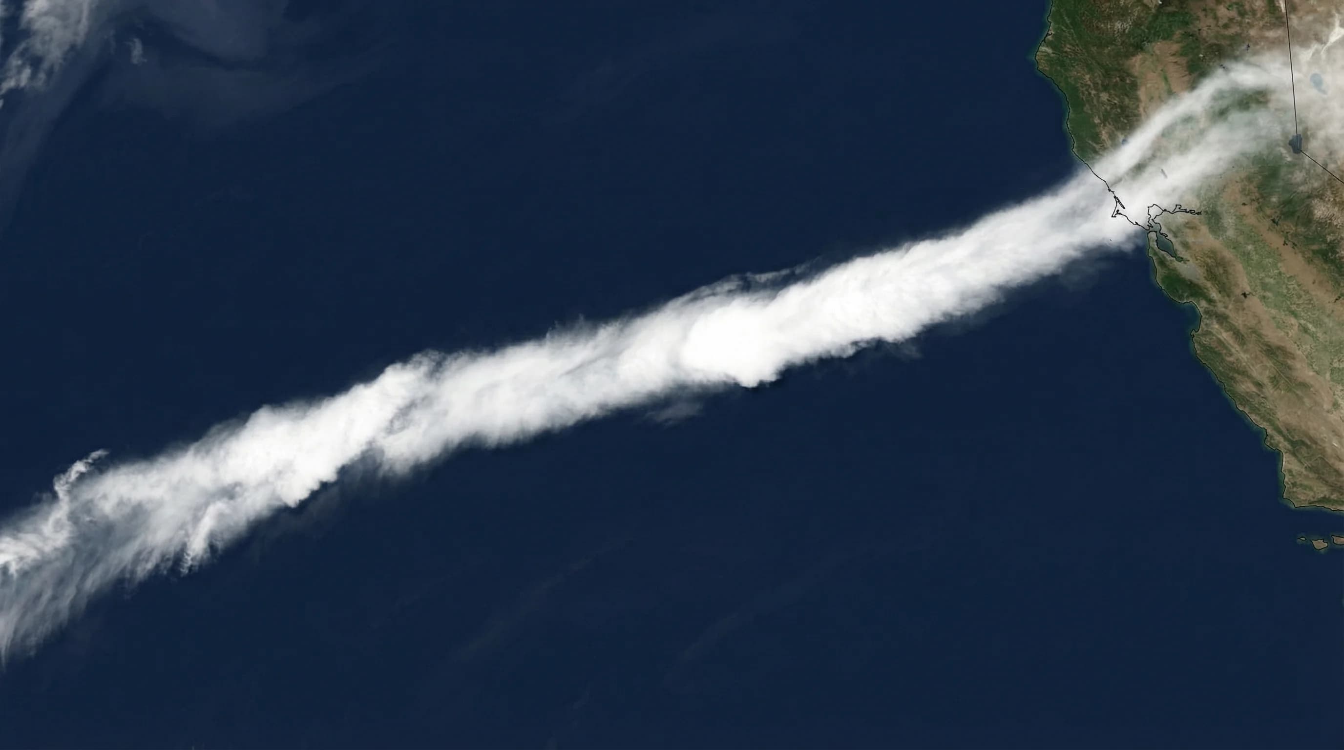
An atmospheric river is a long, narrow band of concentrated water vapor moving through the atmosphere, much like a river moves water across land. These systems are typically 250 to 375 miles wide and over 1,000 miles long, but they can carry an extraordinary volume of moisture. A major atmospheric river can transport more water vapor than the Amazon River moves as liquid, moving it not as liquid water but as water vapor in the lower atmosphere. When that vapor encounters a coastline and is forced to rise, it dumps its moisture as rain or snow with an intensity that can be staggering.
The term “atmospheric river” was coined in the 1990s by researchers at MIT and has since become standard meteorological language. What it describes has always existed; we just lacked a precise term for it. California receives the majority of its annual precipitation from these events, particularly in the coast ranges and Sierra Nevada. A wet California winter is, almost by definition, a winter with several well-placed atmospheric river events. A drought year is one where they miss California entirely or arrive too weakly to make up the deficit.
How They Form
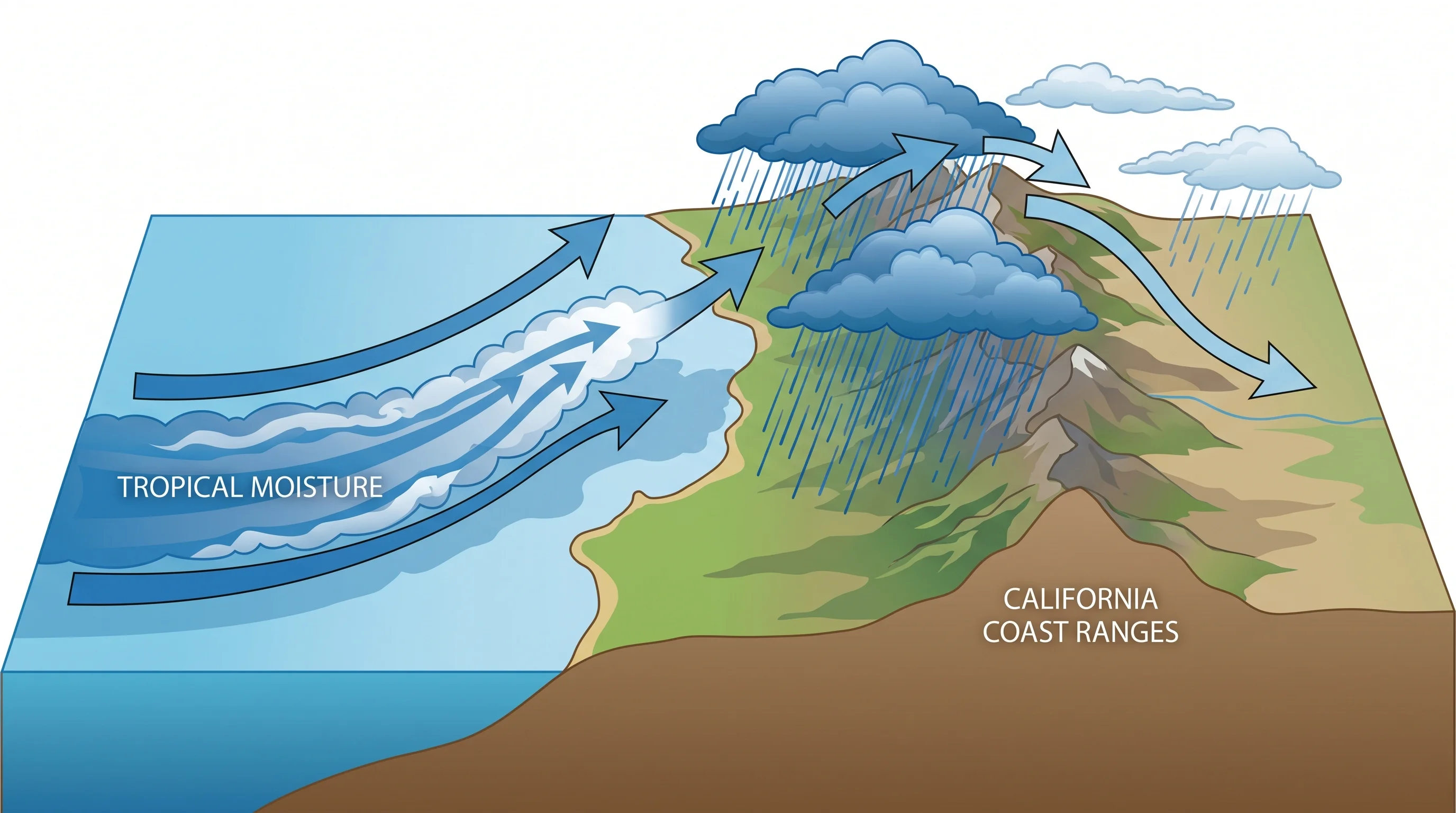
Atmospheric rivers form when surface winds organize to pull large quantities of tropical or subtropical moisture into a narrow corridor, typically associated with a weather system over the Pacific. The key ingredient is warm ocean water, which evaporates readily and loads the atmosphere with water vapor. As upper-level winds steer weather systems toward the coast, they can tap into these moisture reservoirs and channel them into a concentrated stream. The river of vapor then flows thousands of miles, maintaining its structure until it encounters terrain.
When an atmospheric river hits a mountain range, a process called orographic lift takes over. The moist air has nowhere to go but up, and as it rises, it cools, and cooling air cannot hold as much vapor. The moisture condenses and falls as rain or snow, sometimes at extraordinary rates. The coastal ranges of Northern California and the Sierra Nevada act as enormous rain-making machines when atmospheric rivers arrive from the right direction. Locations like Cazadero in Sonoma County and Blue Canyon in the Sierra routinely receive 30 to 40 inches of rain in a single season primarily from a handful of these events.
The Pineapple Express
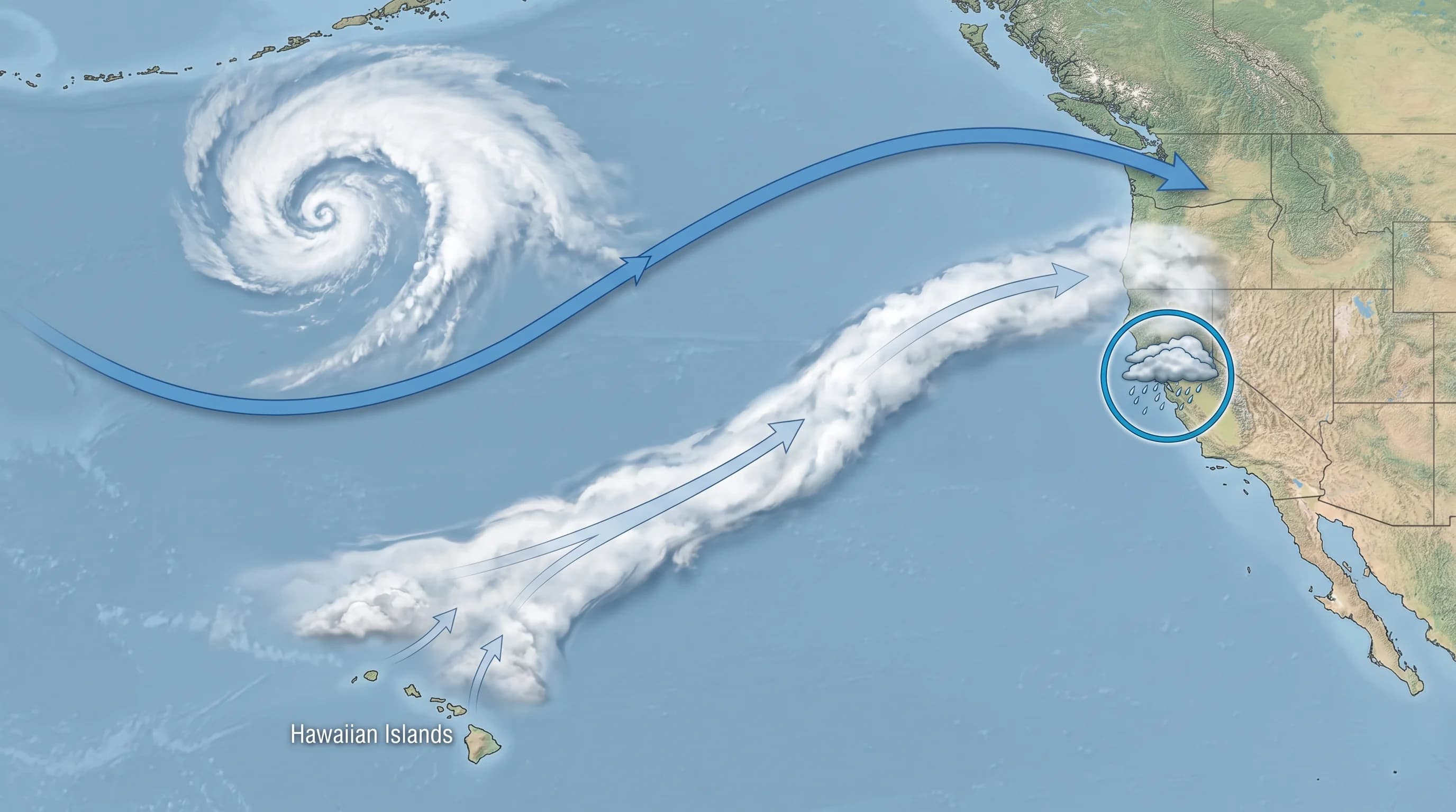
The Pineapple Express is the most famous variety of atmospheric river to affect the Bay Area, and it is the one worth being genuinely excited about from a meteorological standpoint. It originates near Hawaii, in the subtropical Pacific between about 15 and 25 degrees north latitude, where warm ocean water generates abundant atmospheric moisture. A Pineapple Express event occurs when that Hawaiian moisture gets pulled into a weather system tracking toward the California coast, arriving with tropical water vapor that has been accumulating over thousands of miles of warm Pacific ocean.
What makes Pineapple Express events notable is not just their moisture content but their temperature. Because the moisture originates in the subtropics, it is warm. The freezing level in a Pineapple Express event can sit at 10,000 feet or higher in the Sierra, meaning that precipitation that would normally fall as snow falls instead as rain. Rain falling on existing snowpack can cause runoff that dramatically exceeds what the precipitation amount alone would suggest, which is exactly the combination that created the Oroville crisis in 2017. Most Pineapple Express events occur between November and March, aligning with the active storm season, and they can deliver 5 to 10 inches of rain in the Bay Area in 1 to 3 days during a Category 3 or 4 event.
Bay Area Flood Risk
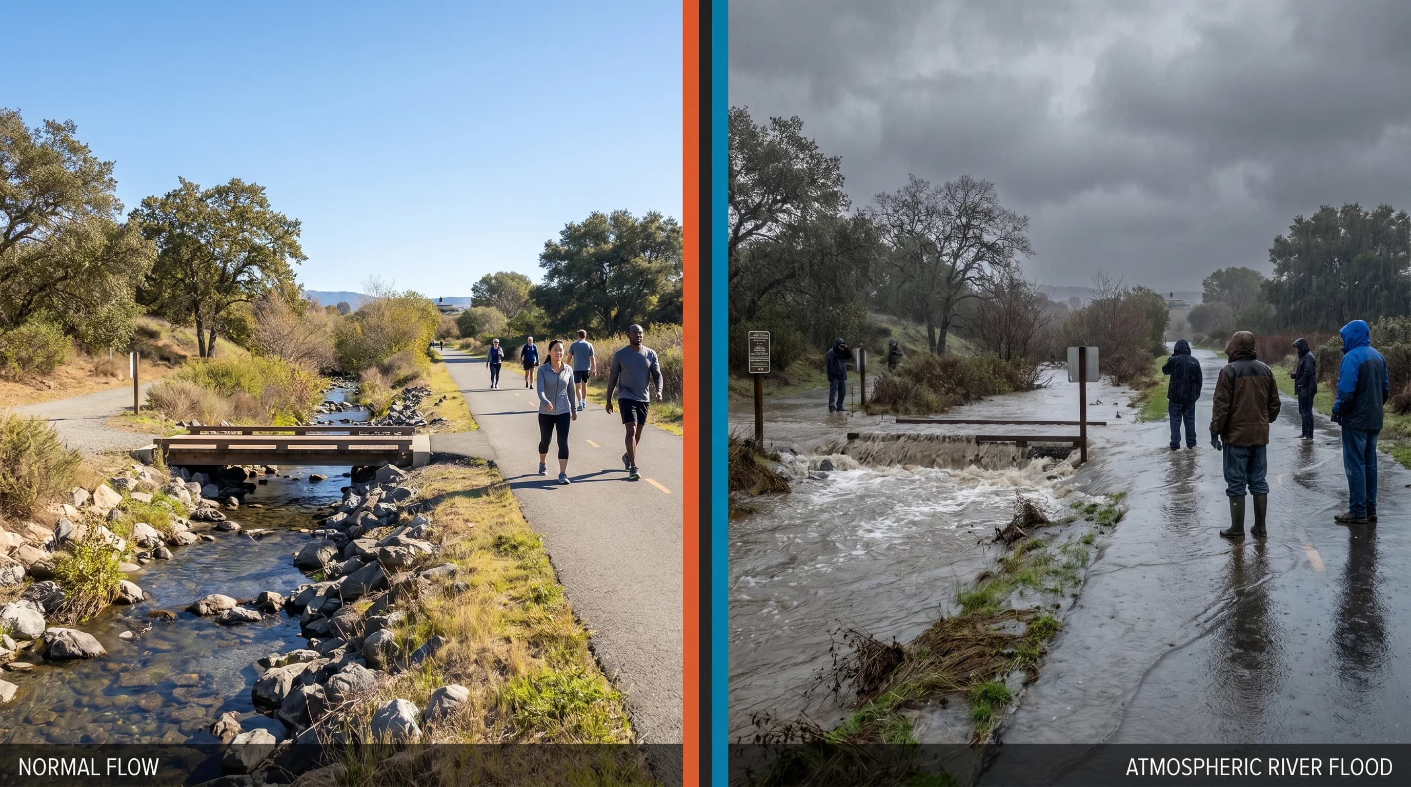
The Bay Area's flood risk from atmospheric rivers is real and geographically specific. Flat areas near creek mouths and bay shorelines face the highest risk, because the combination of heavy rainfall upstream and bay water preventing free drainage can back water up rapidly. Alameda Creek in Fremont, San Mateo Creek in San Mateo, and the numerous small creeks that drain through Oakland and Berkeley into the bay all have histories of flooding during major atmospheric river events.
San Francisco itself is constrained by its peninsular geography and dense urban infrastructure. Storm drains overwhelmed by rapid rainfall lead to street flooding in low-lying areas like the Tenderloin, parts of SoMa, and Civic Center. The bay shoreline, particularly around Coyote Point and the South Bay flats, floods when storm surge and heavy rainfall combine during major events. Hillside neighborhoods face a different risk: saturated soils on steep terrain can fail as landslides, which is why Marin County and the Oakland hills see landslide advisories during extended wet periods.
The Climate Change Connection
Atmospheric rivers are getting wetter. The physics here is straightforward: for every 1 degree Celsius of ocean warming, the atmosphere can hold approximately 7 percent more water vapor. Warmer oceans evaporate more readily, loading passing weather systems with more moisture. An atmospheric river event that would have delivered 4 inches of rain in 1980 might deliver 4.3 to 4.5 inches today, and the trend continues as warming accelerates. This means that the largest atmospheric river events, the ones that already pushed Bay Area flood control infrastructure to its limits, are becoming more intense over time.
At the same time, the dry periods between atmospheric rivers may be getting drier, creating sharper swings between drought and flood. California is already prone to this pattern, with its Mediterranean climate concentrating most precipitation into a short winter window. Climate projections suggest that future California precipitation will come in fewer events of greater intensity, with longer dry spells between them. For Bay Area infrastructure designed around historical norms, this is a significant engineering and planning challenge.
Preparation
The good news is that atmospheric rivers are predictable several days in advance with modern forecast models. The National Weather Service issues atmospheric river watches and warnings, and the forecast tools have become good enough that major events are rarely a surprise. When a Category 3 or higher atmospheric river is forecast for the Bay Area, residents typically have 48 to 72 hours of warning, which is enough time to take meaningful preparation steps.
Practical preparation means clearing gutters and drains before the storm arrives, moving vehicles out of flood-prone areas, checking that sump pumps work, and reviewing evacuation routes if you live near a creek or in an area with landslide history. It also means having emergency supplies for a 72-hour power outage, since downed trees and saturated ground frequently take out power lines during major events. For those with the flexibility to travel, monitoring the forecast and being willing to delay or reroute plans around a major storm is simply smart regional living.
Understanding the Category Scale
Atmospheric rivers are now rated on a Category 1 through 5 scale, developed by researchers at the Center for Western Weather and Water Extremes at UC San Diego. The scale measures integrated vapor transport, which combines the moisture content and wind speed of the system. A Category 1 event is relatively weak and primarily beneficial, delivering useful rain without serious flood risk. Categories 2 and 3 represent moderate to significant events that fill reservoirs and can cause local flooding. Categories 4 and 5 are exceptional, long-duration events capable of widespread flooding and infrastructure damage.
Most Bay Area residents will experience several Category 1 and 2 events in any active winter, a Category 3 event every few years, and a Category 4 event once or twice a decade. The December 2023 and January 2017 events both qualified as Category 4 or higher by this measure. When forecasters describe a “significant atmospheric river” in the forecast, knowing where it falls on that scale is the fastest way to calibrate how seriously to take the warning.