Every winter, Bay Area residents hear the phrase “Pineapple Express” on the news and picture something vaguely tropical: warm rain, dramatic flooding, maybe a sense that the Pacific is overreaching itself. That instinct is meteorologically correct. A Pineapple Express is an atmospheric river that draws its moisture from the tropical Pacific near Hawaii and delivers it to California at jet-stream speed, often in quantities that strain the capacity of every creek, reservoir, and storm drain in its path. It is one of the most consequential weather phenomena in the western United States, and the Bay Area sits directly in its preferred landing zone.
What Is a Pineapple Express?
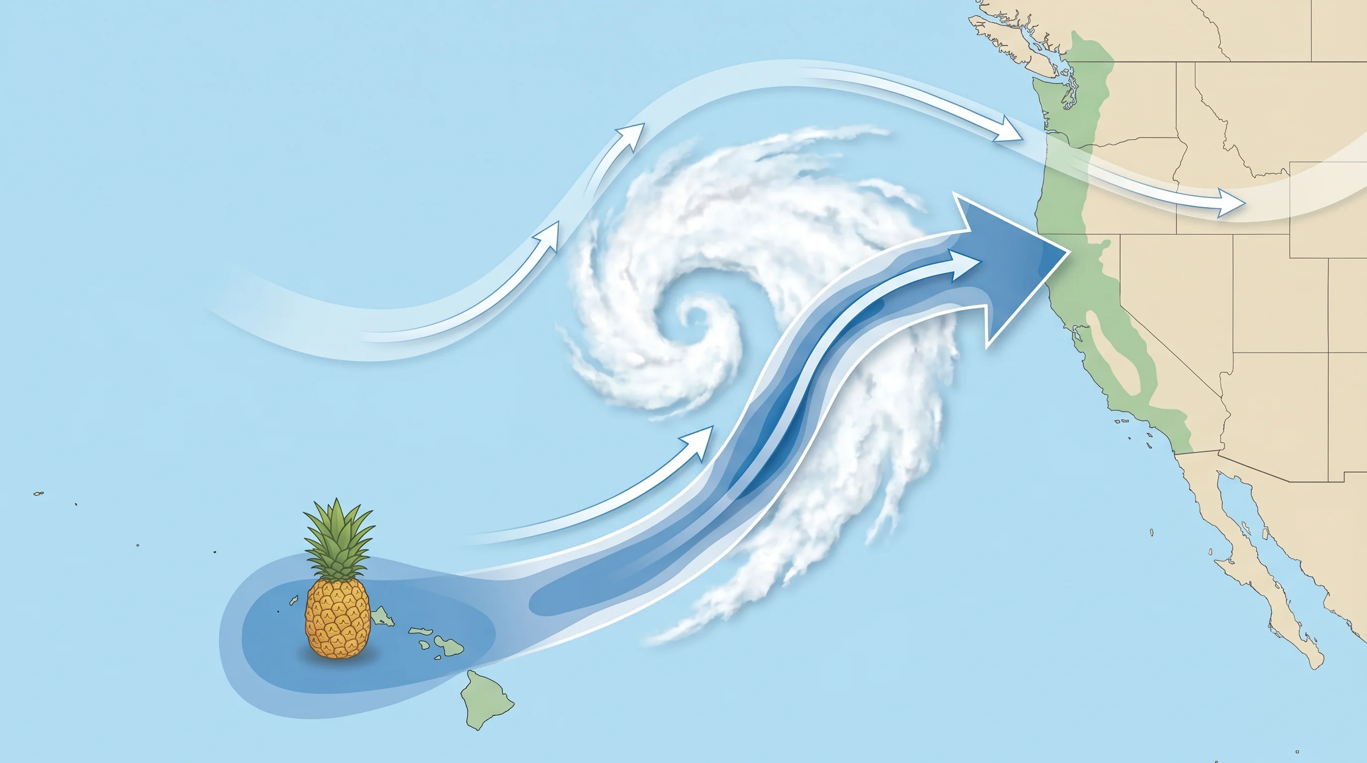
Technically, a Pineapple Express is a subset of atmospheric rivers: specifically, those that originate from tropical moisture sources in the central or eastern Pacific near Hawaii, roughly between 15 and 25 degrees north latitude. Not every atmospheric river that hits California is a Pineapple Express. Many originate from subtropical or higher-latitude moisture sources and have different temperature and moisture characteristics. The Pineapple Express label applies only when the moisture source is genuinely tropical, meaning the air mass carrying rain to California started its journey over warm, low-latitude ocean water near the Hawaiian Islands.
What this means in practice is that Pineapple Express events carry an unusually large amount of water vapor per unit of air, because warm tropical air holds far more moisture than cooler mid-latitude air. When that air mass is channeled by the jet stream toward California and forced to rise over the coastal ranges and Sierra Nevada, it releases its moisture as rainfall at rates that regularly exceed what Bay Area drainage infrastructure was designed to handle.
Why Is It Called That?
The name is informal, and some meteorologists prefer to simply call these events tropical atmospheric rivers, but “Pineapple Express” has stuck because it communicates something real. The moisture comes from near Hawaii, a region associated with pineapples and tropical agriculture, and it arrives via the jet stream at what amounts to express delivery speed. A weather system that forms near Hawaii can deliver rainfall to Northern California within 12 to 36 hours, depending on the speed and trajectory of the jet stream.
The term entered popular use in the 1980s and 1990s as California meteorologists and media needed a way to communicate the distinctiveness of these warm, wet winter events compared to more typical cold-front storms. It works as a piece of public communication even if atmospheric scientists prefer the more precise language. When your local forecaster says a Pineapple Express is inbound, you now know what that means: a large amount of warm tropical moisture is headed directly at you.
The Path from Hawaii to California
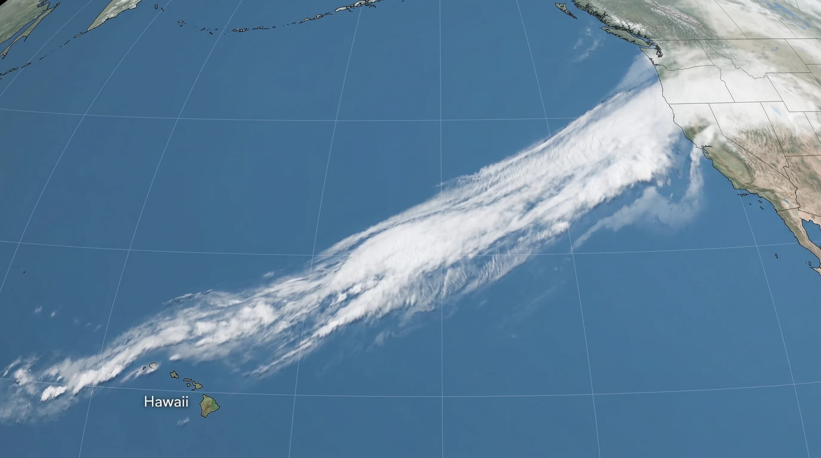
The path a Pineapple Express takes across the Pacific is not a straight line but a curve, following the steering pattern of the jet stream. During winter, the jet stream dips southward over the Pacific and can lock into a position that draws air from the subtropics into a high-latitude delivery trajectory. When this happens, the jet stream acts like a conveyor belt, pulling tropical moisture northeastward and concentrating it into a narrow atmospheric corridor that can be as much as 2,000 miles long and 400 miles wide.
The journey takes several days for the water vapor, but the storm system itself arrives as the whole atmospheric configuration reaches the coast. In a typical event, a surface low-pressure system off the California coast pulls moisture-rich air out of the tropics, the jet stream focuses it into a narrow band, and the whole system then moves onshore and encounters the terrain. The coastal ranges catch the first rainfall, the Central Valley floor receives moderate amounts, and the Sierra Nevada concentrates the heaviest totals at its western slopes, where the forced ascent of moist air produces the most intense precipitation.
Historical Events: When Pineapple Express Storms Changed California
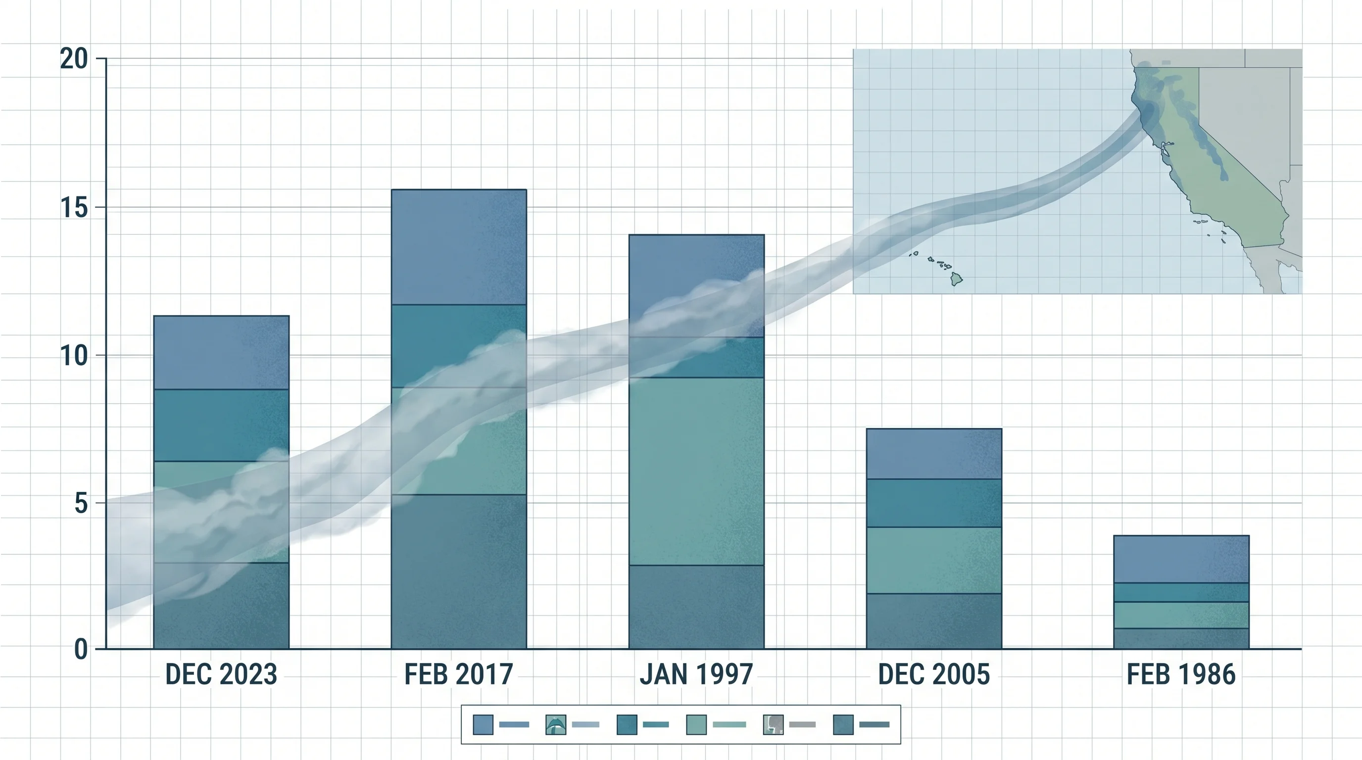
The January 1997 Pineapple Express event is one of the most studied in California history. It produced extreme rainfall across Northern California over several days, saturated the Sierra snowpack with warm rain, and generated runoff that caused the Feather River and American River to approach or exceed their levee systems. Sacramento experienced some of its worst flooding in decades. The event was a stark demonstration of what happens when a high-elevation snowpack that has been building for months is suddenly exposed to warm rain: the snow melts rapidly and adds its stored water to the rainfall runoff simultaneously.
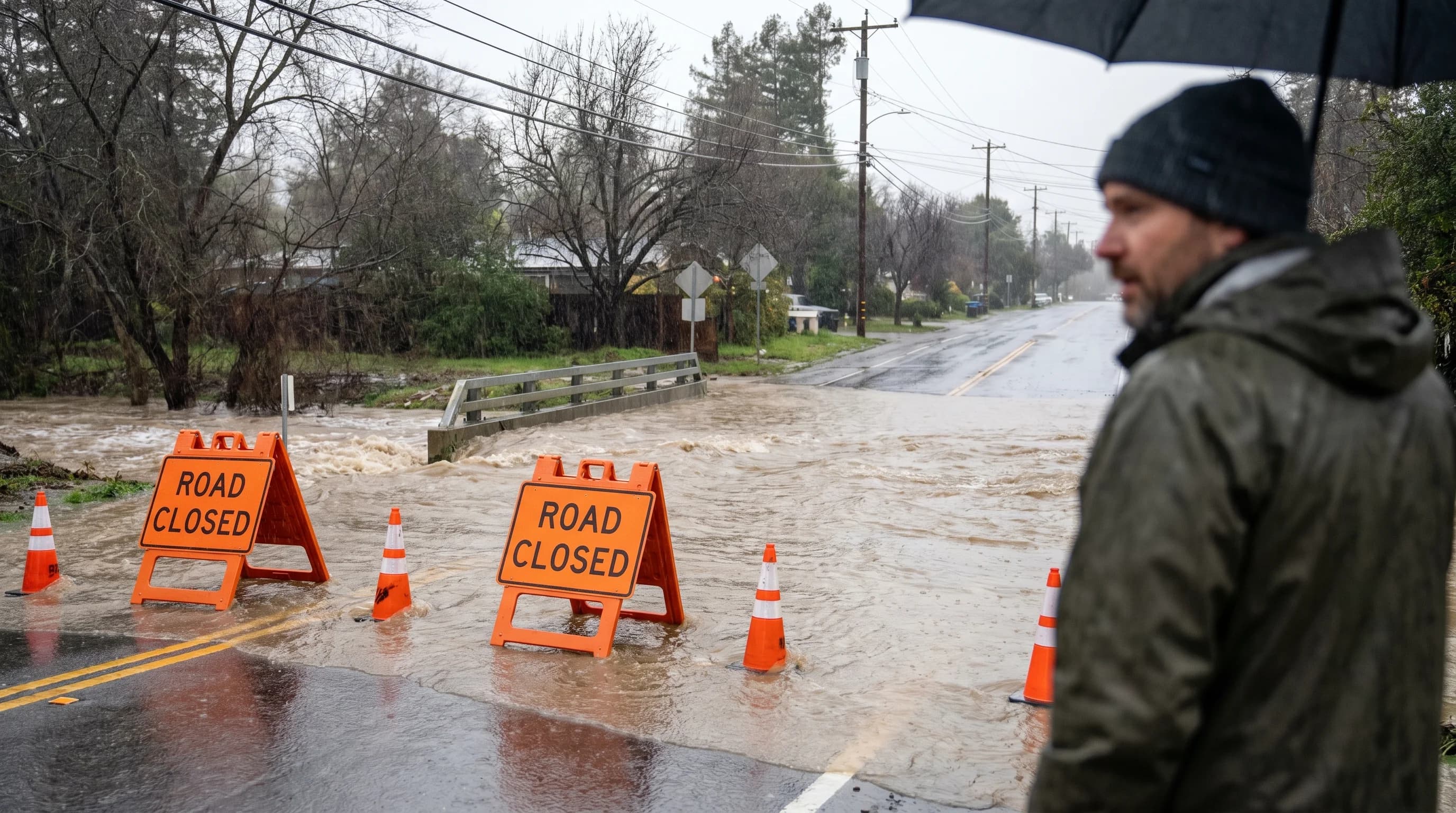
February 2017 brought a similar story. A series of Pineapple Express events in late January and February filled California reservoirs from emergency drought levels to capacity in weeks. Hetch Hetchy went from critically low to full. Oroville Dam, the tallest dam in the United States, received so much inflow that its primary spillway failed and an emergency earthen spillway was eroded so severely that 188,000 people downstream were evacuated. The December 2023 event that flooded Fremont and surrounding communities was another in this lineage: warm, tropical, fast, and difficult to fully contain.
Why These Storms Are Warmer Than Regular Winter Storms
The temperature character of a Pineapple Express event is one of its defining features and one of its most consequential for flood risk. Because the moisture originates in the tropics, the air mass is warm. This pushes the freezing level higher in the atmosphere than it would be during a typical cold-front winter storm. During a standard Northern California winter storm, the freezing level in the Sierra Nevada might sit at 5,000 to 7,000 feet. During a Pineapple Express event, it can sit at 9,000 to 11,000 feet, sometimes even higher.
This matters enormously for runoff. Precipitation that falls above the freezing level becomes snow, which is temporarily stored in the snowpack and released gradually over weeks or months. Precipitation below the freezing level falls as rain, which runs off immediately. When the freezing level rises to 10,000 feet in the Sierra, almost all of the mountain range's watershed is below that threshold, meaning that a large portion of precipitation that would normally become snowpack instead runs directly into rivers and reservoirs as immediate liquid runoff. If there is already snow on the ground at elevations now below the freezing level, that snow also melts, adding its stored water to the rain runoff simultaneously.
The Blessing and the Curse: Water Supply vs. Flooding
California\'s relationship with Pineapple Express events is genuinely ambivalent. On one hand, these storms are capable of filling reservoirs that were dangerously depleted by drought in a matter of weeks. A single strong Pineapple Express event can add 1 to 2 trillion gallons to state water supplies, the kind of input that took the 2015-2017 drought from catastrophic to manageable in a single wet season. For San Francisco's water supply, for East Bay MUD, for the entire agricultural system of the Central Valley, these storms are not optional: they are how the region gets its water.
On the other hand, a Pineapple Express event that arrives after a wet winter, when soils are already saturated and reservoirs are already near capacity, leaves water managers with few good options. Releasing reservoir water in advance of a storm reduces flood risk, but it wastes water that might not be replaceable if the rest of the winter is dry. Holding water risks catastrophic overflows. Pineapple Express events arriving after already-wet winters force real-time decisions under enormous uncertainty, and the consequences of a wrong call can be severe.
How to Prepare When One Is Coming
Modern forecast models can identify a Pineapple Express forming near Hawaii 5 to 7 days before it reaches California. NOAA's Weather Prediction Center issues atmospheric river outlooks, and the National Weather Service offices in the Bay Area provide specific rainfall and flood forecasts as the event approaches. When a Pineapple Express watch or warning is issued for the Bay Area, the preparation checklist is essentially the same as for any major atmospheric river event.
Clear gutters and downspouts before the storm arrives. Move cars out of areas that flood. Confirm evacuation routes from your neighborhood and know whether you are in a designated flood zone or landslide hazard area. Sign up for county emergency alerts. Have 72 hours of supplies available in case power goes out, because Pineapple Express events frequently include high winds in addition to extreme rainfall, and wind-related outages can last several days.
The storms themselves are not going away. If anything, a warming tropical Pacific means future Pineapple Express events will carry more moisture per event than the historical average. The forecast tools are good, the warning time is meaningful, and the preparation is not complicated. The most important thing Bay Area residents can do is treat these forecasts seriously rather than assuming they will be overstated. The December 2023 event, the February 2017 event, the January 1997 event: every one of them was accurately forecast days in advance, and every one of them still surprised people who did not take the warnings at face value.