seasonalsafetyclimate science

The 1861-62 Great Flood: California's Worst Storm

By SFBayWeather||Updated |6 min read
The 1861-62 Great Flood: California's Worst Storm

Key Takeaways

  • The 1861-62 winter brought multiple successive atmospheric river events that turned the Sacramento Valley into an inland sea 300 miles long and 20 miles wide.
  • The Bay Area was severely affected: San Jose and the Santa Clara Valley were submerged for weeks, and flooding throughout the region destroyed farms, ranches, and infrastructure.
  • The event bankrupted California's state government, killed an estimated one-quarter of California's cattle, and forced the evacuation of the state capital by boat.
  • USGS planning for the ARkStorm scenario, a modern recurrence of the 1862 event, estimates damages of $400 billion or more and displacement of millions of people.
  • Geological evidence suggests comparable floods occurred roughly every 100-200 years in California's history, making a modern recurrence a matter of when, not if.

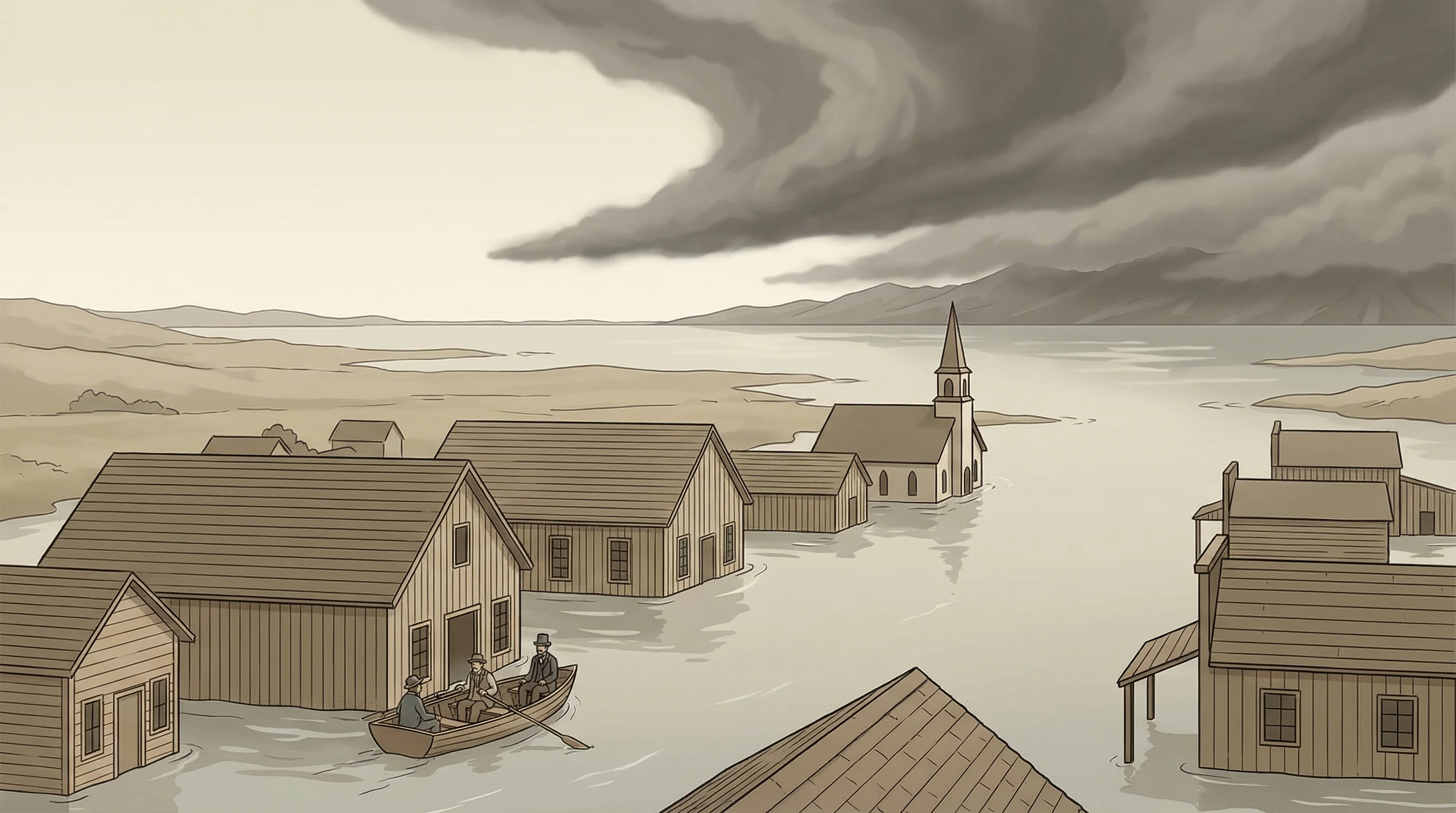
The winter of 1861 to 1862 brought California a storm sequence that has no modern equivalent. Beginning in late December 1861 and extending through January 1862, a series of atmospheric river events struck the state in rapid succession, each one depositing enormous rainfall totals before the previous flood had fully receded. The Sacramento Valley became an inland sea 300 miles long and 20 miles wide. The state capital had to be evacuated by boat. One-quarter of California's cattle died. The state government went bankrupt. In the Bay Area, the lowlands were under water for weeks, and the damage was severe enough that it reoriented California's entire approach to water management and infrastructure. The event is often called the Great Flood of 1862, and it remains the benchmark for catastrophic rainfall in California history.

The Storms That Caused the Great Flood

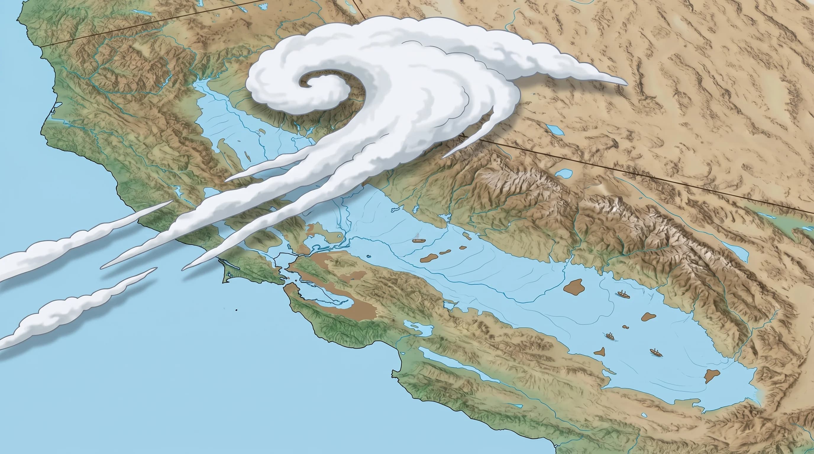
The 1861-62 flood was caused by what modern meteorologists would classify as an exceptionally active atmospheric river season. Atmospheric rivers, narrow bands of concentrated water vapor that transport tropical moisture northward from the Pacific, are the primary mechanism for California's major rainstorms. In a normal wet year, the Bay Area might experience four or five significant atmospheric river events between November and March. In the winter of 1861-62, the events came in rapid succession with little recovery time between storms.

Contemporary accounts describe rain beginning in the Sierra Nevada in late November 1861 and continuing nearly continuously through January. The Sierra Nevada snowpack, which had been building through early winter, was then hit by a warm atmospheric river event that converted existing snow to water simultaneously with the rain. This combination, heavy rainfall plus rapid snowmelt, is one of the most flood-producing scenarios possible, and it delivered an enormous volume of water to California's rivers in a very short period.

Historical illustration or map of the 1862 California flood showing the Sacramento Valley as a vast inland sea, with flooded lowlands and towns submerged under water
The Great Flood of 1862 turned the Sacramento Valley into an inland sea 300 miles long and 20 miles wide. The Bay Area's lowlands were similarly submerged for weeks. The event remains the benchmark for catastrophic California flooding.

The Flood in the Bay Area

In the Bay Area, the flooding was extensive and prolonged. The low-lying areas around San Jose and the Santa Clara Valley floor were submerged for weeks. The creeks that drain the Santa Cruz Mountains and the Diablo Range overflowed into the flatlands, and the normal tidal zone of the Bay expanded dramatically. What is now downtown San Jose was under several feet of water. Farms and ranches throughout the South Bay were destroyed, and the cattle losses were catastrophic for an economy that was still largely ranching-based.

San Francisco, on its peninsula, was more protected from the worst flooding by its topography, but the surrounding lowlands were severely affected. The Coyote Valley, the Napa Valley, and the Sonoma Valley all flooded extensively. The town of Napa was inundated. Throughout the Bay Area, roads became impassable, mail stopped running, and communication with the rest of California was severed for days at a time. The flooding lasted far longer than modern floods because there were no flood control channels, levees, or reservoirs to manage the water.

The ARkStorm Scenario: Could It Happen Again?

The 1861-62 event has become the basis for USGS and other agencies' planning for what they call the ARkStorm scenario, a hypothetical modern recurrence of a 1862-scale event. The analysis is sobering. The Central Valley is now home to millions of people rather than thousands. The Bay Area has been developed over the lowlands that were completely flooded in 1862. Modern flood control infrastructure would be overwhelmed. Estimates suggest that a modern recurrence could cause over $700 billion in total damages and displace millions of people.

The 1861-62 flood is not a one-in-a-million event. Geological evidence from lake sediments and tree rings suggests that comparable floods occurred roughly every 100 to 200 years in California's pre-settlement history. The last event of this magnitude happened before significant European settlement. The question for California is not whether such a storm sequence will recur, but whether the state will be adequately prepared when it does.

Frequently Asked Questions

What caused the Great Flood of 1862?

The Great Flood was caused by a series of successive atmospheric river events, bands of concentrated Pacific moisture, struck California in late December 1861 and through January 1862. Each event deposited enormous rainfall before the previous flood had receded. The Sierra Nevada snowpack, which had been building through early winter, was then hit by a warm atmospheric river that converted existing snow to water simultaneously with heavy rain, an extremely flood-producing combination.

How did the 1862 flood affect the Bay Area?

The Bay Area's low-lying areas were severely flooded. The Santa Clara Valley floor, including what is now downtown San Jose, was submerged under several feet of water for weeks. The Napa Valley and Sonoma Valley flooded extensively. Farms and ranches throughout the region were destroyed, and cattle losses were catastrophic. Roads became impassable, mail stopped running, and communication was severed. The flooding lasted far longer than modern floods because there were no flood control channels, levees, or reservoirs.

Could the 1862 flood happen again?

Yes. USGS's ARkStorm scenario models a modern recurrence of a 1862-scale event and estimates it would cause $400 billion or more in damages and displace millions of people. Geological evidence from lake sediments and tree rings suggests comparable floods occurred roughly every 100-200 years in California's pre-settlement history. The Central Valley and Bay Area are now developed to levels that would make a modern recurrence catastrophically more damaging than the 1862 event.

What is the ARkStorm scenario?

ARkStorm (Atmospheric River 1000-year Storm) is a USGS planning scenario for a modern recurrence of a 1862-scale flood event in California. Published in 2011, the scenario models a 40-day sequence of atmospheric river events that could dump 10 feet of water on parts of California, flood much of the Sacramento and San Joaquin Valleys, and cause economic losses exceeding $400 billion, roughly four times the economic loss from the 1994 Northridge earthquake. Emergency managers and flood control agencies use the ARkStorm scenario to plan levee reinforcement and evacuation strategies.

How long did the 1862 flooding last in the Bay Area?

The initial flooding began in late December 1861 with the first major storm events. Flooding in the low-lying Bay Area valleys, particularly the Santa Clara Valley floor and the Napa and Sonoma Valleys, persisted for weeks and in some areas for months. The Central Valley remained an inland sea from December through the following spring. Without modern flood control infrastructure, natural drainage was the only way for water to recede, and the flat valley terrain made that process extremely slow.

Live Bay Area Conditions

Compare fog, temperature, wind, and comfort across the map.

See which microclimates are clear, cool, windy, or warming up right now.

Open the Weather Map
🔒Privacy Policy📄Terms of Service