Bay Area winters are defined by storms that arrive from the Pacific with varying force and frequency. Unlike the summer season, which is shaped by a single persistent pattern, the marine layer and North Pacific High, winter brings a succession of systems across the storm track: some weak and drizzly, some severe enough to flood roads, knock out power, and dump feet of snow on the surrounding mountains. Because the Bay Area sits at the southern margin of the storm track, small shifts in atmospheric circulation can mean the difference between a drought year and a flood year.
The Bay Area Storm Season
Meaningful rainfall in the Bay Area is confined almost entirely to the wet season, which runs from November through March. April and October bring occasional rain at the edges of the season, but the core of precipitation falls in the five winter months. This pattern, typical of Mediterranean climates globally, means that the Bay Area experiences its entire year's water supply in a very compressed window.
Average annual rainfall in the Bay Area varies enormously by location: San Francisco receives around 23 inches, Oakland around 20, San Jose around 15, and the North Bay hills around Kentfield can receive 60 inches or more. The Santa Cruz Mountains and the higher terrain of the East Bay hills also receive far more precipitation than the valley floors, due to orographic enhancement. This topographic amplification means that a storm that drops an inch of rain in Oakland might drop three or four inches on the ridgeline above it.
Types of Bay Area Winter Storms
Bay Area winter storms fall into several categories. The most common are ordinary mid-latitude cyclones: organized frontal systems with a warm front followed by a cold front, a period of steady moderate rainfall, and then clearing as the cold front passes. These systems account for most of the region's annual precipitation and are generally manageable, producing no more than a few inches of rain in a single event.
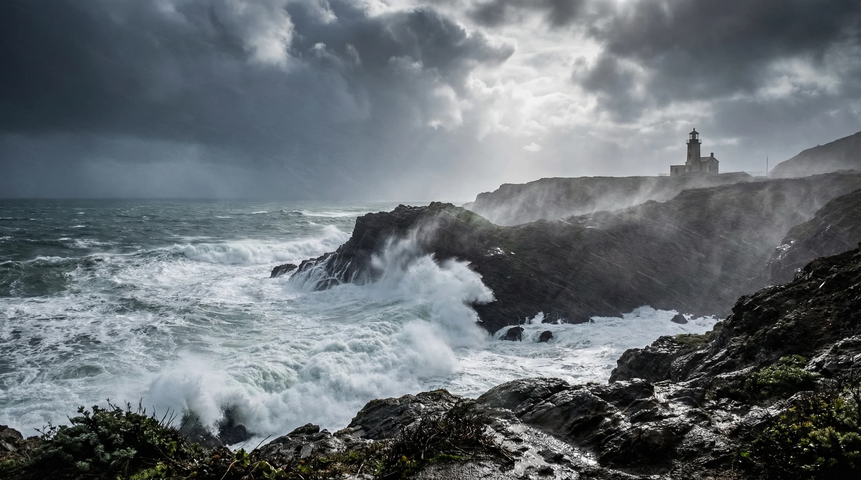
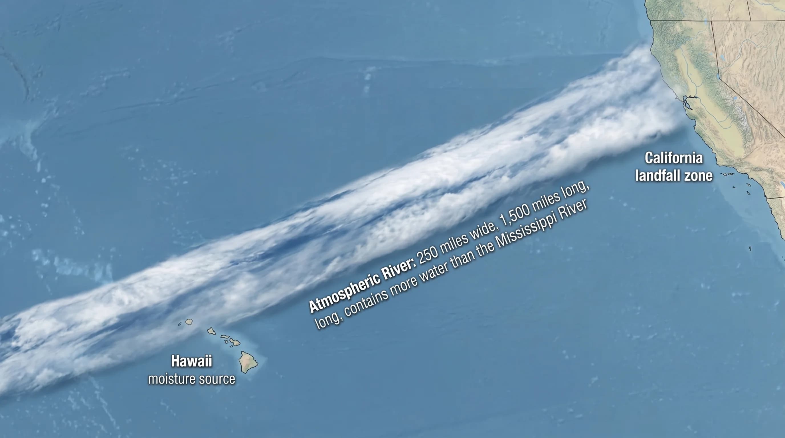
Atmospheric river events are a different class of storm. These are narrow corridors of concentrated water vapor in the atmosphere, sometimes called the Pineapple Express when the moisture originates near Hawaii, that can deliver extraordinary amounts of precipitation. When an atmospheric river makes landfall on the Bay Area, the event can drop 5 to 10 inches of rain in a 48-hour period, swelling rivers to flood stage, triggering landslides on the steep slopes of Marin County and the Santa Cruz Mountains, and overwhelming storm drains in low-lying areas. The severe storms of winters 2016-17, 2021-22, and 2022-23 were all dominated by atmospheric river sequences that produced historic flooding in parts of the Bay Area.
At the other extreme, high-pressure systems that block the storm track can produce weeks or even months of dry, sunny winter weather. Drought years in California are often the result of persistent blocking high-pressure systems that deflect storms to the north or south, leaving the Bay Area without rain for the entire winter season.
El Niño, La Niña, and the Bay Area Winter
The Bay Area's year-to-year rainfall variability is closely tied to El Niño and La Niña cycles in the tropical Pacific. El Niño years, characterized by anomalously warm sea surface temperatures in the central and eastern tropical Pacific, tend to shift the storm track southward and increase the probability of above-normal precipitation in California. La Niña years do the opposite, shifting the storm track northward and increasing the probability of below-normal precipitation and drought in the Bay Area.
The exceptionally wet winter of 2022-23 is a recent example: California received record-breaking precipitation, with Bay Area reservoirs filling completely by January and widespread flooding in the San Joaquin Valley. The La Niña conditions that dominated the preceding three winters had produced a severe multi-year drought. These alternating cycles mean that Bay Area water managers cannot plan based on any single year's conditions but must manage for the full range of variability.
Winter Weather by Location
Winter brings the Bay Area closer to weather uniformity than any other season, every community experiences some version of the wet season, but significant differences remain. The coast receives the first force of storms and the most orographically enhanced rainfall. The inland valleys receive less precipitation but are more prone to flooding when rivers run full. The hills see the most precipitation and, at higher elevations, the region's only regular snowfall.
Mount Hamilton, in the Diablo Range east of San Jose, receives snow several times most winters. Mount Tamalpais in Marin County and the higher ridges of the Santa Cruz Mountains above 2,000 feet see snow occasionally. Mount Diablo, visible from most of the East Bay, receives snow a few times per decade, rare enough that a dusting on its upper slopes stops Bay Area residents in their tracks. The Sierra Nevada, while not technically Bay Area, is close enough that good Sierra snowpack years mean abundant spring water for the region's reservoirs, tying Bay Area water supply directly to what happens on a mountain range 150 miles to the east.