climate sciencemicroclimatesseasonal

How Bay Area Hills and Mountains Create Localized Rain

By SFBayWeather||Updated |6 min read
How Bay Area Hills and Mountains Create Localized Rain

Key Takeaways

  • Annual rainfall in the Bay Area ranges from 15 inches (San Jose, flat South Bay) to 60+ inches (upper Marin watershed, above 1,500 feet), the difference is almost entirely explained by orographic enhancement.
  • When moist air encounters a hill or mountain and is forced upward, it cools, condenses, and produces rain on the windward side. The leeward side receives much less. That is the rain shadow effect.
  • Mount Tamalpais at 2,574 feet produces 55-60 inches of annual rainfall, more than double San Francisco's 23 inches, despite being only 12 miles away in the same climate system.
  • Fog drip, moisture that coastal redwoods and forests capture from the marine layer and deliver to the forest floor, supplements official rainfall measurements by the equivalent of several additional inches per season.
  • The Santa Cruz Mountains show the same pattern: La Honda and Skylonda average 40-50 inches while San Jose, in the rain shadow, averages only 15 inches.

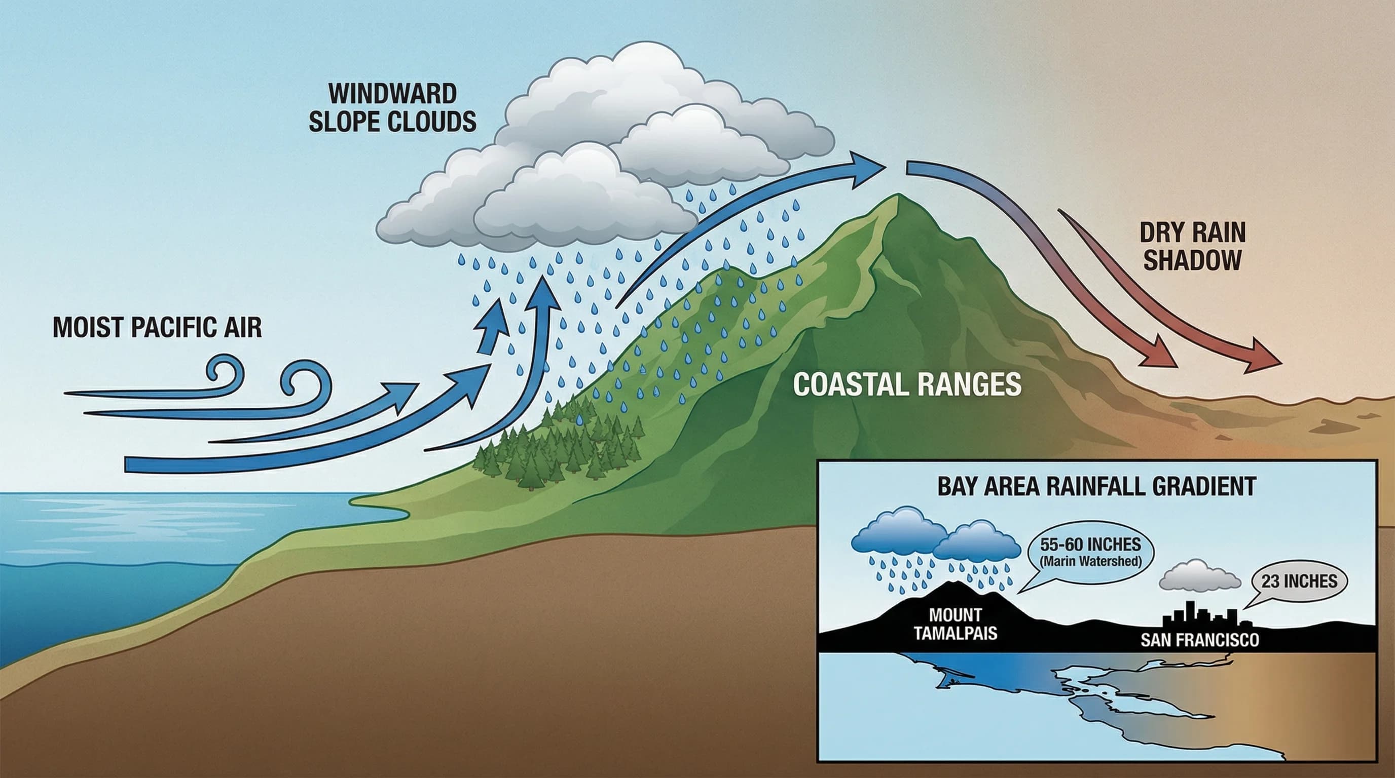
The Bay Area's rainfall is not distributed evenly. Within 30 miles, annual precipitation can range from 15 inches to 60 inches, and the difference is almost entirely explained by topography. The hills and mountains that give the Bay Area its dramatic scenery also function as precipitation machines, wringing moisture from Pacific storms at rates that flat lowland areas never see. This process, called orographic enhancement, is why the Marin watershed receives twice San Francisco's rainfall, why the east-facing Berkeley Hills are drier than the west-facing slopes of Mount Tamalpais, and why some of the Bay Area's most lush forests grow in areas that receive no irrigation at all.

How Orographic Rain Forms

When moist air encounters a mountain or hill, it is forced upward. As the air rises, it expands and cools at the standard atmospheric lapse rate, roughly 3.5 degrees Fahrenheit per 1,000 feet. When the air cools to its dew point, water vapor condenses into cloud droplets. If the lifting continues long enough, those droplets grow large enough to fall as rain or snow. The mountain's windward side, the face that meets the incoming air, receives the enhanced rainfall. The leeward side, where the air descends and warms, is drier, a region known as a rain shadow.

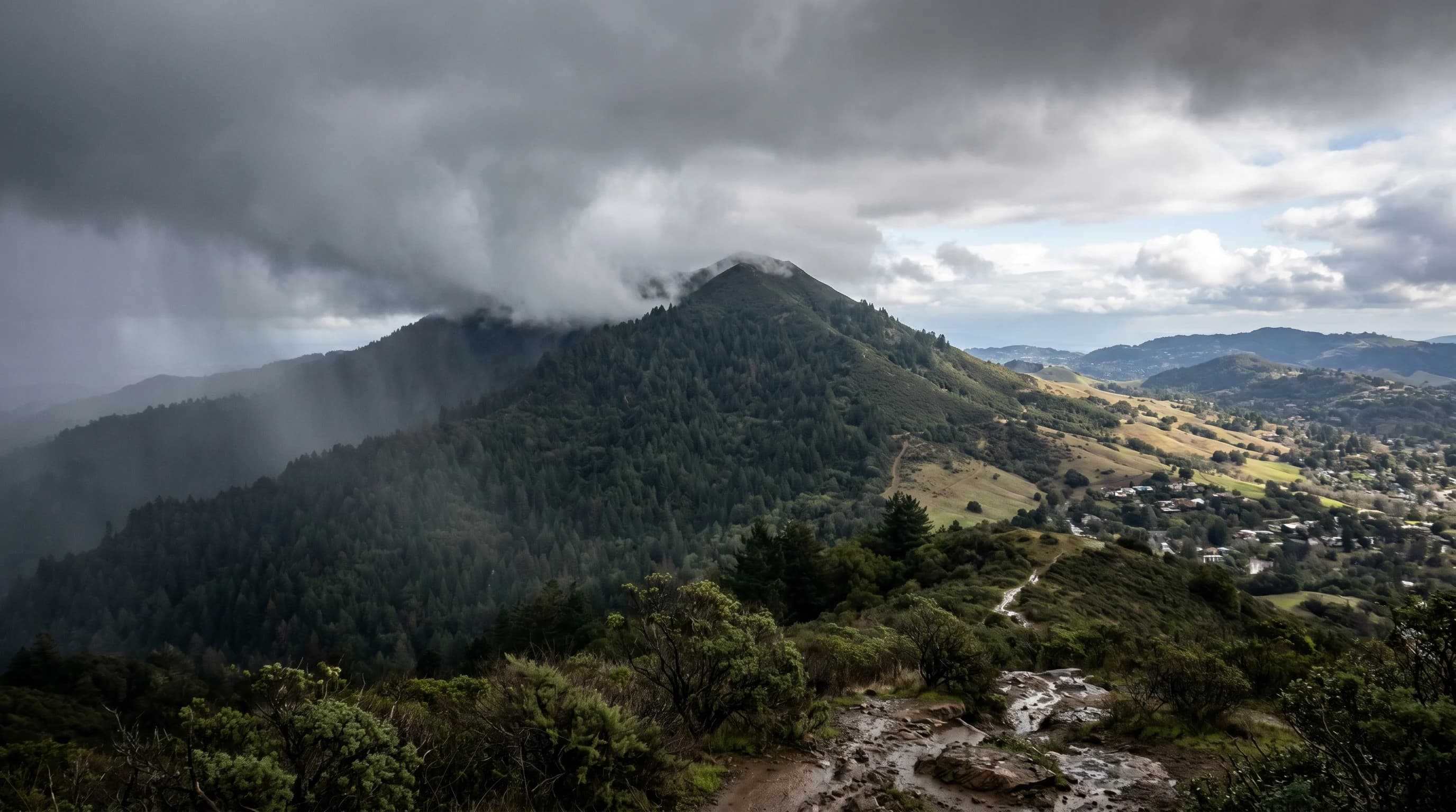
The Bay Area's terrain is ideally configured to produce orographic enhancement during winter storms. Pacific storms approach from the west or northwest, carrying moisture from the open Pacific. The Coast Ranges, the Santa Cruz Mountains, the Marin Hills, the Diablo Range, intercept this moisture-laden air and force it upward. The steeper and higher the terrain, the more dramatic the enhancement. Mount Tamalpais at 2,574 feet produces far more rainfall than the low hills of the East Bay, which in turn produce more than the flat South Bay.

Diagram of orographic rainfall showing moist Pacific air being forced up a mountain, forming clouds and rain on the windward side, and creating a dry rain shadow on the leeward side
Orographic enhancement explains why Mount Tamalpais receives 55-60 inches of annual rain while San Francisco, 12 miles away, gets 23 inches. The mountain forces moist Pacific air upward, triggering rainfall on the windward slopes.

Bay Area Rainfall Extremes

The numbers illustrate the effect clearly. San Francisco, on the relatively flat tip of the Peninsula, averages about 23 inches of annual rainfall. The Marin watershed, behind the steep ridges of Mount Tamalpais and the Bolinas Ridge, averages 55 to 60 inches, more than double San Francisco, in the same climate system. The community of Kentfield at the base of Mount Tamalpais averages 55 inches. The upper reaches of the Marin watershed above 1,500 feet can receive 65 to 70 inches in wet years.

The Santa Cruz Mountains show a similar pattern. Summit-area communities like La Honda and Skylonda average 40 to 50 inches of annual rainfall, while San Jose in the sheltered Santa Clara Valley averages only 15 inches. The mountains rise to barely 3,000 feet, but their west-facing orientation directly intercepts Pacific storm moisture. The redwood forests that clothe the Santa Cruz Mountain slopes exist entirely because of this orographic enhancement; without it, the natural vegetation would be oak woodland or even chaparral.

Fog Drip: The Invisible Rainfall

Orographic processes also produce a form of precipitation that official rain gauges miss: fog drip. When the marine layer flows over coastal hills and ridges, the fog droplets collide with vegetation and coalesce into drops large enough to fall. A large Coast Redwood can intercept hundreds of gallons of fog drip per year, and a dense coastal forest can capture fog moisture equivalent to several inches of additional rainfall per season. This is not merely a curiosity; in summer, when rain is essentially absent, fog drip is the primary water input sustaining coastal redwood forests and the vegetation that depends on them.

Muir Woods receives almost no summer rainfall in the conventional sense, yet the forest remains lush through August. The explanation is fog drip: the ancient redwoods intercept the marine layer that flows over the Marin Headlands and delivers it, drop by drop, to the forest floor. The trees are not just beneficiaries of the fog; they are active participants in creating the soil moisture conditions that sustain their own roots. The Marin fog forest is a fog-drip ecosystem, and orographic enhancement is the process that makes it possible.

Rain Shadows: The Dry Side

The leeward sides of Bay Area mountains receive significantly less rainfall than the windward faces. The Diablo Valley east of the Berkeley Hills is in the hills' rain shadow, receiving 18 to 20 inches while the Berkeley Hills' western slopes get 25 to 30. The interior wine country valleys, Livermore, parts of the Napa Valley floor, sit in complex rain shadow positions that partially explain their lower rainfall compared to the outer coast. Orographic enhancement and its inverse, the rain shadow, are the key to making sense of Bay Area precipitation maps: the rainfall variations look extreme, but they are entirely explicable by the terrain.

Frequently Asked Questions

What is orographic rainfall?

Orographic rainfall occurs when moist air is forced upward by a mountain or hill. As the air rises, it expands and cools. When it reaches its dew point, water vapor condenses into cloud droplets. If the lifting continues long enough, those droplets grow large enough to fall as rain. The windward side of the terrain receives the enhanced rainfall; the leeward side, where air descends and warms, receives less; the rain shadow.

Why does Marin get so much more rain than San Francisco?

The Marin watershed sits behind the steep ridges of Mount Tamalpais and the Bolinas Ridge, which intercept Pacific storm moisture and force it upward. This orographic enhancement produces 55-60 inches of annual rainfall in the Marin watershed, compared to 23 inches at San Francisco on the flat Peninsula tip; more than double, despite being in the same climate system and separated by only 12 miles. The Kentfield community at the base of Mount Tamalpais averages 55 inches, and the upper watershed above 1,500 feet can receive 65-70 inches in wet years.

What is fog drip and how much does it add to Bay Area rainfall?

Fog drip occurs when marine layer fog flows over coastal hills and the fog droplets collide with vegetation, coalescing into drops large enough to fall. Coastal redwoods, with their massive needle surface area, are particularly effective fog collectors; a large redwood can intercept hundreds of gallons of fog drip per year. Dense coastal forests can capture fog moisture equivalent to several additional inches of rainfall per season. In summer, when rain is essentially absent, fog drip is the primary water input sustaining coastal redwood forests and the vegetation that depends on them.

What is the rain shadow effect in the Bay Area?

The rain shadow is the dry zone on the leeward (downwind) side of a mountain range, where descending air warms and moisture dissipates. In the Bay Area, the clearest examples are San Jose (15 inches annually), which sits in the rain shadow of the Santa Cruz Mountains, and Livermore, which sits in the rain shadow of the Diablo Range. On the other side of those same mountains, La Honda and Ben Lomond in the Santa Cruz foothills average 40-50 inches, and the Marin watershed averages 55-60 inches. The contrast is entirely due to orographic enhancement on the windward side and rain shadow suppression on the leeward side.

Which Bay Area location gets the most rain?

The upper Marin watershed, on the slopes of Mount Tamalpais above 1,500 feet, receives more annual rainfall than anywhere else in the immediate Bay Area; typically 60-70 inches in wet years and 50-60 inches in average years. The community of Kentfield at the base of Mount Tamalpais averages around 55 inches. The Santa Cruz Mountains above La Honda and Skylonda also receive 40-50 inches. These high rainfall totals are almost entirely due to orographic enhancement: moist Pacific air is forced up steep slopes and wrung out as rain before it can descend into the valleys behind.

Live Bay Area Conditions

Compare fog, temperature, wind, and comfort across the map.

See which microclimates are clear, cool, windy, or warming up right now.

Open the Weather Map
🔒Privacy Policy📄Terms of Service