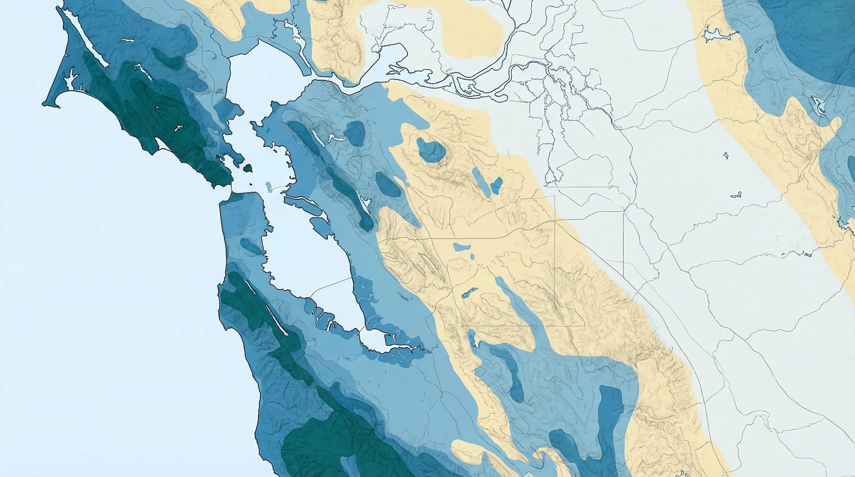
The Bay Area's famously varied microclimates do not just affect temperature and fog. They produce dramatic differences in rainfall distribution that make it possible for two locations 10 miles apart to receive wildly different amounts of annual precipitation. The Santa Cruz Mountains near the coast can receive 50 to 60 inches of rain per year while the Livermore Valley, less than 30 miles away across the Diablo Range, averages just 12 to 14 inches. That uneven distribution shapes everything from water resources to vegetation to fire risk to daily life across the region.
Why Mountains Make More Rain: Orographic Lift
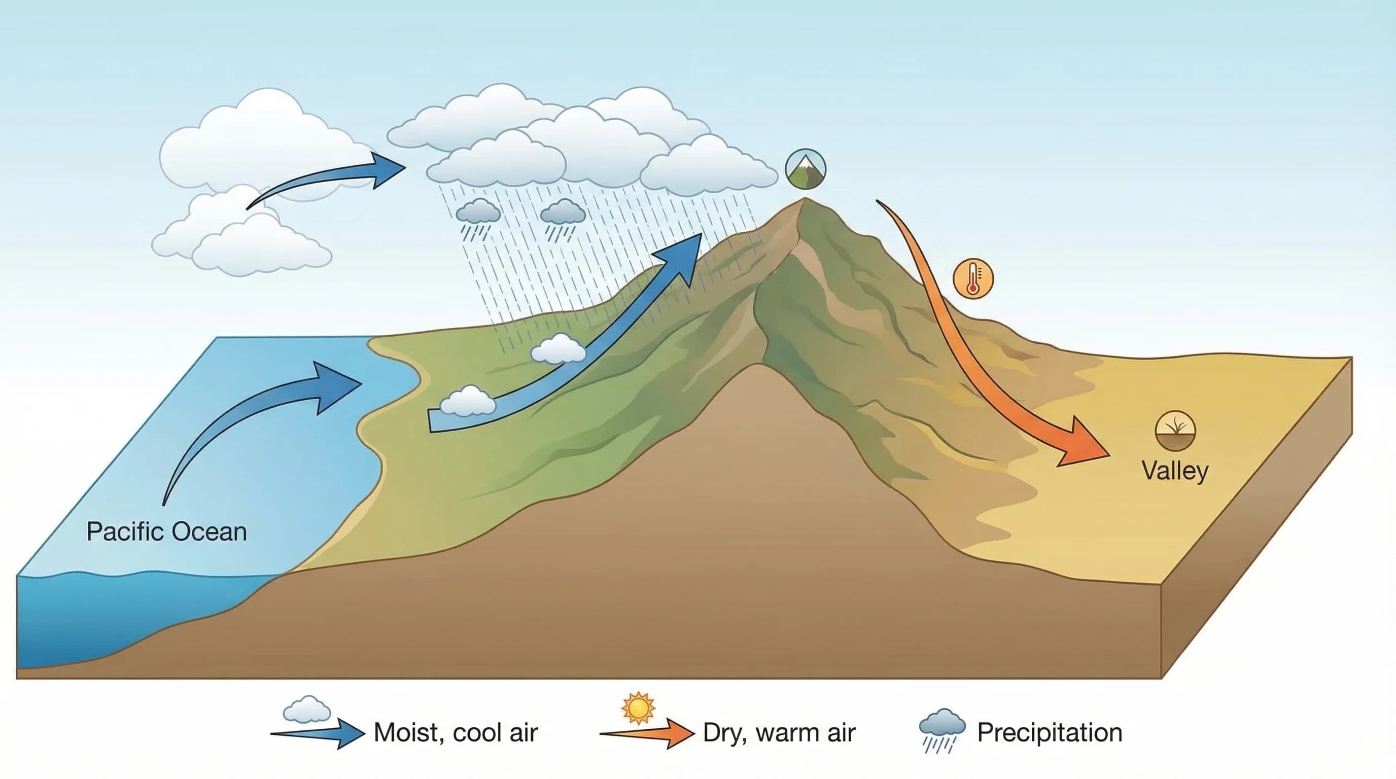
The primary mechanism behind Bay Area rainfall distribution is orographic lift. When moist air flowing in from the Pacific encounters a mountain range, it is forced to rise. As air rises, it cools at roughly 3.5 degrees Fahrenheit per 1,000 feet. When it cools enough to reach the dew point, water vapor condenses into clouds and then falls as rain. The higher the mountain and the more moisture-laden the air, the more rainfall the windward side receives.
The Bay Area has multiple parallel mountain ranges running roughly north-south that intercept moist Pacific air at different distances from the coast. The Santa Cruz Mountains along the Peninsula, the Berkeley Hills and the Diablo Range in the East Bay, and the Marin Highlands north of San Francisco all create their own orographic rainfall zones. Each range squeezes moisture from incoming weather systems, leaving progressively less moisture available for communities on the downwind side.
The Wettest and Driest Parts of the Bay Area
The wettest parts of the Bay Area are the high ridges of the Santa Cruz Mountains, the summit areas of Mount Tamalpais in Marin, and the ridgeline of the Diablo Range above 3,000 feet. Mount Tamalpais stations receive 60 to 70 inches of annual rainfall, comparable to parts of Oregon and the Pacific Northwest. Ben Lomond Mountain in the Santa Cruz Range receives similar totals. These locations intercept the full brunt of incoming Pacific storms before the mountains strip moisture from the air.
The driest parts of the Bay Area are the inland valleys that lie in the rain shadow of the Diablo Range: Livermore, the Tri-Valley, Brentwood, and Antioch. These communities sit behind multiple mountain ranges that have progressively extracted moisture from the incoming air. Livermore averages about 14 inches per year. Antioch averages closer to 12 inches, approaching the rainfall levels of semi-arid inland regions and dramatically lower than coastal San Francisco's 22 inches.
The city of San Francisco itself sits in an interesting middle position. Its relatively flat terrain and the moisture that flows directly through the Golden Gate without encountering a major mountain barrier gives it moderate rainfall of about 22 inches annually. Communities on the direct windward slopes of the Peninsula hills, like Woodside and Los Altos Hills, can receive 30 to 40 inches because they are exposed to orographic enhancement without the rain shadow effect.
How Rain Shadows Work: Why Livermore Is So Dry
When air rises over a mountain range and releases moisture on the windward side, it descends on the leeward side and warms through adiabatic compression, gaining roughly 5.5 degrees per 1,000 feet of descent. This warming, drying air on the downwind side creates what is called a rain shadow. The Diablo Range east of the bay creates a significant rain shadow over the Livermore Valley, San Ramon Valley, and the Tri-Valley communities.
The rain shadow effect is amplified in the Bay Area because the air masses must cross not one but two or three mountain ranges before reaching the inland valleys. Pacific air enters through the Golden Gate and coastal gaps, loses moisture to the Berkeley Hills and the Diablo Range in sequence, and arrives in the Livermore Valley as considerably drier air than it started. By the time storm systems reach Brentwood and Antioch on the eastern edge of the bay, they have been wrung out by two or three orographic events.
Annual Rainfall by Bay Area Region
The variation across the Bay Area is striking when you look at specific numbers. Woodside in the Santa Cruz Mountains foothills receives about 30 inches annually, while Palo Alto at the base of those same hills receives about 16 inches. Oakland receives about 25 inches while Livermore, 25 miles east, gets about 14 inches. San Rafael in Marin receives about 35 inches while Napa, 20 miles northeast across hills and valley terrain, receives about 26 inches. Mill Valley on the slopes of Mount Tamalpais receives 45 to 50 inches annually.
These are not small differences. They translate into fundamentally different vegetation zones, fire risk profiles, water supply conditions, and seasonal weather patterns across the region. Communities in high-rainfall zones depend on local runoff and watershed storage. Communities in rain shadow zones depend more heavily on imported water from state and federal water projects that move Sierra Nevada snowpack across the state.
What Rainfall Distribution Means for Outdoor Activities
Bay Area rainfall distribution has real practical implications for outdoor recreation. If you are planning a winter hike, trails in the Santa Cruz Mountains and Marin Highlands will be wetter, muddier, and more likely to have flowing water and waterfalls. The same storm that leaves Livermore slightly damp may leave Muir Woods trails completely saturated. Plan accordingly: wetter areas need more drying time after storms before becoming hikeable.
For visitors wanting to see spring wildflowers, the coastal ranges with their higher rainfall produce the most abundant blooms, but the timing depends on cumulative winter rainfall. In high-rainfall years, the Santa Cruz Mountains and Marin headlands reach their wildflower peak in February through April. In drought years, blooms are sparse and short-lived.
The rain shadow zones, while drier, offer their own advantages for winter and early spring outdoor activities. Livermore and the Tri-Valley are more likely to have clear days during winter storm periods because incoming weather systems have partially dried out by the time they reach the inland valleys. After a coastal storm, the Livermore area often clears first while the Peninsula hills are still wet. Use this pattern to your advantage when planning winter outdoor activities.