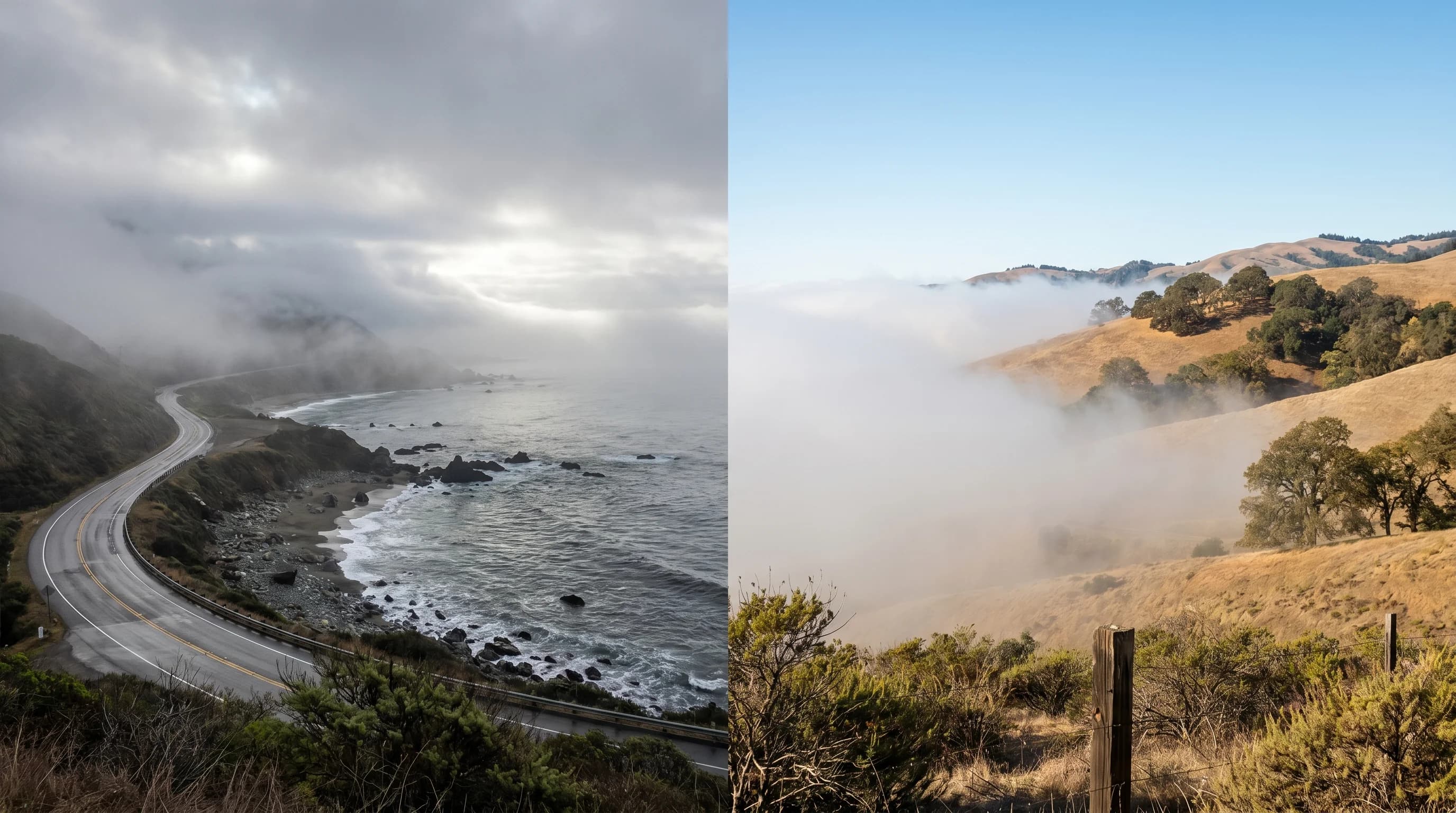
The marine layer is a mass of cool, moist air that forms over the Pacific Ocean and pushes inland over the Bay Area coast. It is the single most important weather feature in the region, responsible for San Francisco's summer fog, the 30-degree temperature differences between the coast and inland valleys, the sharp San Francisco microclimates, and the natural air conditioning that keeps the Bay Area mild while Sacramento bakes at 105 degrees. The marine layer typically sits between the ocean surface and an altitude of 1,000 to 2,000 feet, capped by a temperature inversion that acts as a lid preventing the cool air from mixing upward. When the top of the marine layer reaches saturation, the moisture condenses into the low stratus clouds and fog that define Bay Area summers.
How Does the Marine Layer Form?
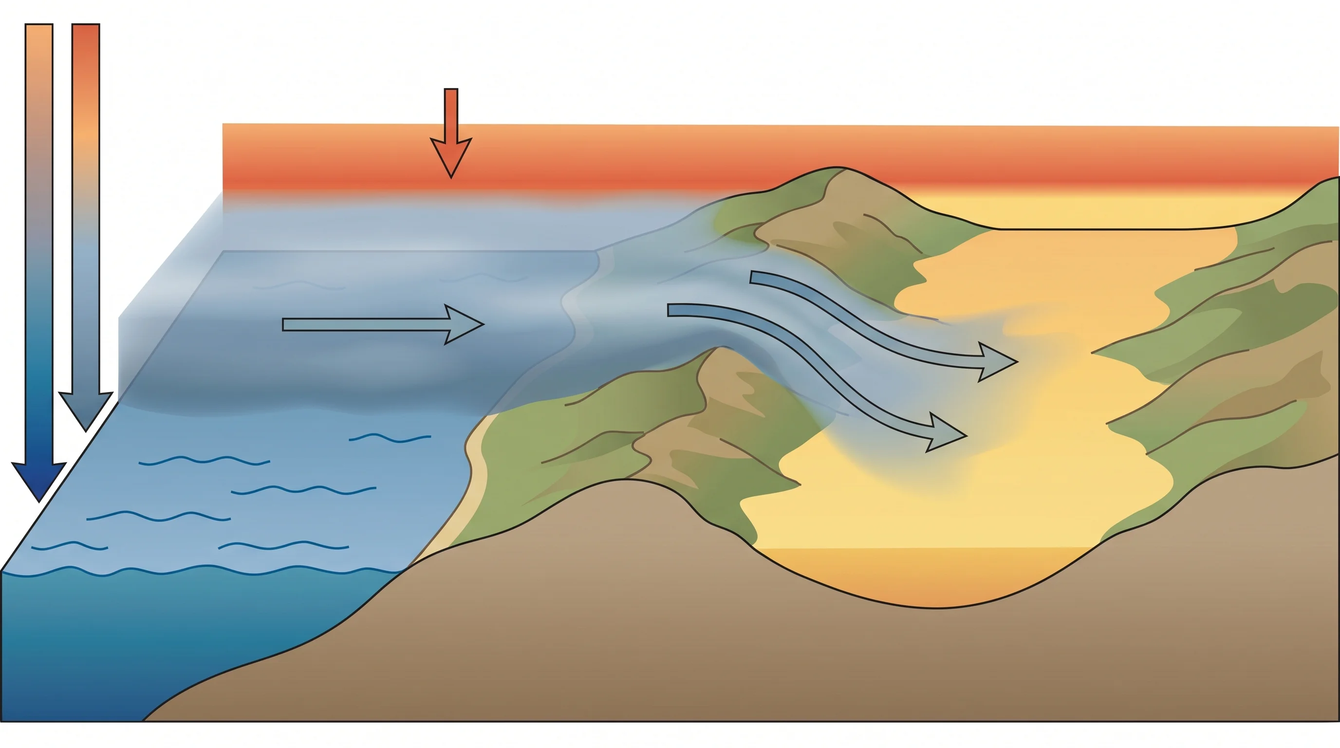
The marine layer forms through a specific chain of atmospheric events. The California Current carries cold water southward along the coast, keeping ocean surface temperatures between 50 and 56 degrees F year-round. The North Pacific High, a semi-permanent high-pressure system that parks itself off the California coast in summer, creates persistent sinking air at altitude. That sinking air warms as it descends (a process called subsidence), creating a warm layer above the cool ocean air. The boundary between the cool air below and the warm air above is the inversion.
Below the inversion, the air in contact with cold ocean water cools and absorbs moisture through evaporation. This creates a shallow layer of cool, humid air, typically 500 to 1,500 feet thick. When the humidity in this layer reaches 100%, the moisture condenses into fog or low stratus clouds. The depth and moisture content of the marine layer determine whether the Bay Area gets fog at the surface, a low cloud deck overhead, or clear skies with just cool air. A deep, moist marine layer produces thick fog. A shallow, drier one produces overcast skies that burn off by noon.
Why Does the Marine Layer Matter for Bay Area Weather?
The marine layer is the mechanism behind nearly every distinctive Bay Area weather pattern. It is why San Francisco is 15-20 degrees colder than Oakland on summer afternoons. It is why the Outer Sunset averages 60 degrees in July while Walnut Creek hits 95 degrees. It is the reason the sea breeze pulls cool air through every gap in the coastal mountains each afternoon, creating the wind that defines Golden Gate recreation.
The marine layer also controls air quality. When the inversion is low and strong, it traps pollutants and wildfire smoke near the surface, producing poor air quality episodes. When the inversion lifts or weakens, vertical mixing disperses pollutants and clears the air. The same inversion that brings fog can simultaneously trap smoke from fires burning 100 miles away, creating days when the Bay Area has both fog and unhealthy air.
Is the Marine Layer the Same as Fog?
No, and the distinction matters. The marine layer is the entire mass of cool, moist air below the inversion. Fog is what happens when the moisture in that air mass condenses at the surface. You can have a marine layer without fog: the air is cool and moist, but the cloud base sits at 500 or 1,000 feet above the ground, producing an overcast sky rather than ground-level fog. Fog forms when the marine layer is deep enough and moist enough that the cloud base drops to the surface.
The marine layer is also distinct from tule fog, which is a radiation fog that forms inland in the Central Valley during winter. Tule fog forms from ground cooling on clear, calm nights, while the marine layer is driven by ocean temperature and the Pacific High. They are fundamentally different fog types with different formation mechanisms, seasons, and geographic distributions.
When Is the Marine Layer Strongest?
The marine layer is strongest from May through August, peaking in June and July. This is when the temperature contrast between the cold ocean and the hot Central Valley is greatest, the North Pacific High is most robust, and the inversion is most persistent. During peak season, the marine layer can push through the Golden Gate and across the bay every afternoon like clockwork, retreating overnight and returning the next day.
The marine layer weakens in September and October as the Central Valley cools, the Pacific High shifts, and the inversion becomes less pronounced. This is why September and Octoberare San Francisco's warmest months: the marine layer's grip loosens, allowing sunshine and warmth to reach the coast. In winter, the marine layer is largely absent because the jet stream brings Pacific storms that disrupt the inversion pattern entirely. Winter Bay Area weather is driven by storm systems, not by the marine layer.
Understanding the marine layer is understanding Bay Area weather. It is the reason the region has its famous microclimates, the reason summer fog blankets the coast, and the reason you can drive 30 minutes from the cold, gray coast to a hot, sunny valley. Every other weather phenomenon in the Bay Area is either caused by the marine layer, modified by it, or defined by its absence.