On a typical summer morning in the Bay Area, you can drive from the fog-shrouded valley floor into warm sunshine simply by gaining 1,000 feet of elevation. This seems backwards. Temperature normally decreases with altitude, and it is backwards. It is a temperature inversion, one of the most important and characteristic features of Bay Area weather. Inversions are responsible for the marine layer's sharp ceiling, for the winter fog that locks into valleys for days at a time, and for the pollution concentrations that accumulate over the region's most densely populated lowlands. Inversions explain why Bay Area weather behaves the way it does at every level of the atmosphere.
What Is a Temperature Inversion?
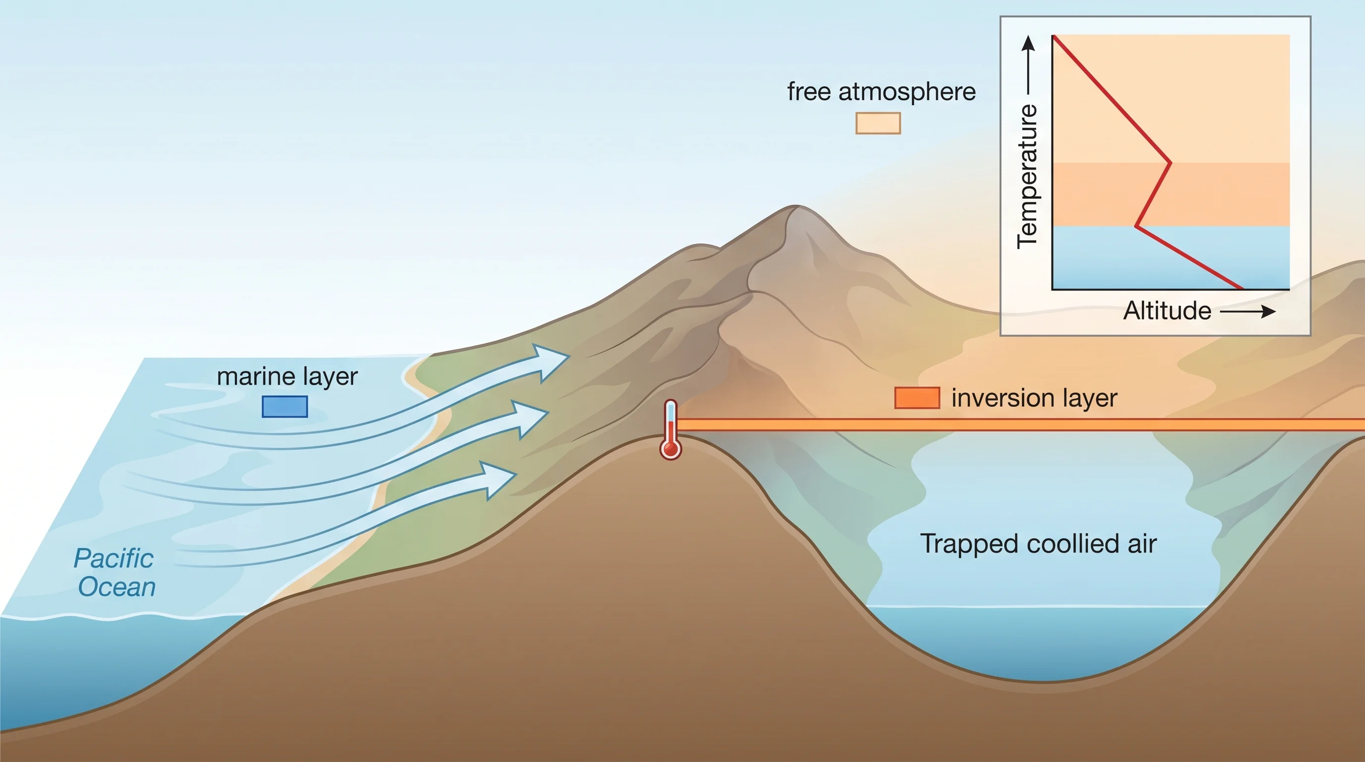
In the standard atmosphere, temperature decreases with altitude at a rate of about 3.5 degrees Fahrenheit per 1,000 feet, the environmental lapse rate. Warm air at the surface is less dense than the cool air above it and rises freely, creating the vertical mixing that normally keeps the lower atmosphere well-stirred. A temperature inversion reverses this: a layer of warm air sits above a layer of cool air, creating a stable cap that prevents the cool lower air from rising. The warm layer acts as a lid.
The Bay Area experiences two main types of inversions on a regular basis. The marine layer inversion is a subsidence inversion, formed when the North Pacific High's descending air compresses and warms as it sinks, creating a layer of warm, dry air above the cool, moist marine air at the surface. The tule fog inversion is a radiation inversion, formed when the ground cools on clear nights and chills the air immediately above it below the air higher up. Both inversions trap air in the lower atmosphere and prevent vertical mixing.
The Marine Layer Inversion
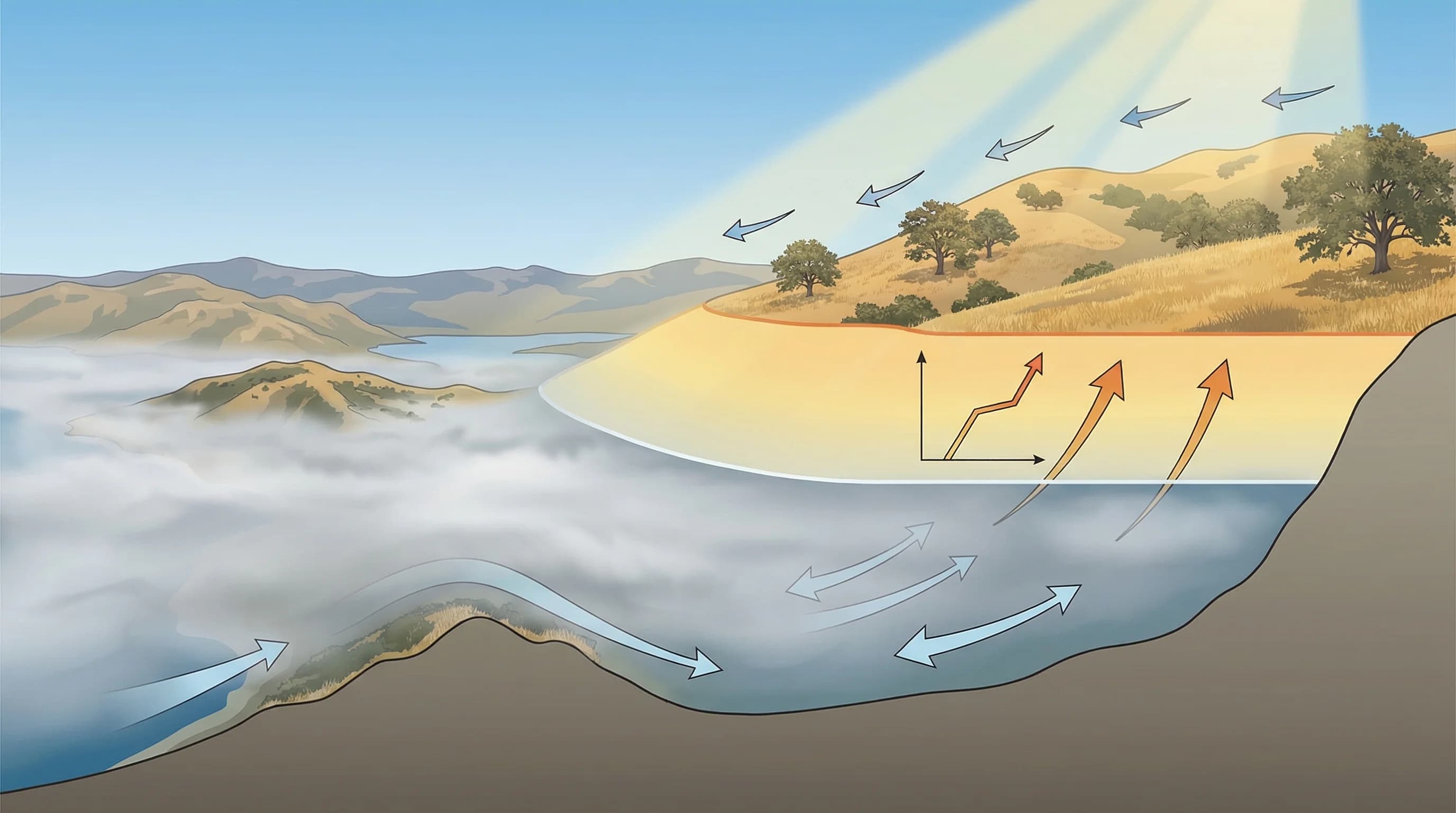
The marine layer's characteristic fog ceiling, the sharp line where fog ends and blue sky begins, is the visible signature of the subsidence inversion. Below the inversion, the air is cool, moist, and saturated, forming fog. Above it, the air is warm, dry, and clear. The height of the inversion base determines everything about the marine layer's character: when the inversion base is at 1,000 feet, the fog fills the valleys and submerges the cities; when it is at 2,500 feet, only low-lying areas are fogged and the hills rise into sunshine.
The inversion base rises and falls on a roughly seasonal schedule, peaking in summer when the North Pacific High is strongest. On strong marine push days in July, the inversion can dip to 500 or 600 feet, low enough to keep the fog dense all day and prevent any significant burn-off. On weaker marine push days, the inversion base is higher and the fog lifts easily by late morning. Bay Area weather forecasters watch the marine layer inversion height as one of the primary predictors of daytime fog behavior.
Valley Inversions and Tule Fog
The winter radiation inversion operates differently but with equally dramatic results. On clear, calm nights in fall and winter, the ground radiates heat to space and cools. The air immediately above the cold ground cools by contact, becoming denser than the warmer air above it. Cold air drains from slopes and ridges into valley floors, pooling in the lowest terrain. If the air cools to its dew point, moisture condenses and tule fog forms. The inversion that keeps the fog trapped is a near-surface radiation inversion, typically only a few hundred feet deep, but intense enough to maintain zero-visibility conditions for days at a time.
The Bay Area's geography makes it particularly susceptible to winter valley inversions. The region is full of enclosed valleys and basins, including the Livermore Valley, the Santa Clara Valley around San Jose, and the Sacramento Valley just north of the Bay Area, that trap cold air efficiently. Once an inversion forms and tule fog develops in these basins, the fog itself reflects sunlight back into space, preventing the solar heating that would otherwise warm the ground and break the inversion. The result can be persistent fog lasting three to seven days without significant breaks, a pattern that is frustrating for residents but physically elegant in its self-reinforcing logic.
Inversions and Air Quality
Temperature inversions are the Bay Area's most important air quality driver. When an inversion caps the lower atmosphere, pollutants from traffic, industrial sources, and wood burning are trapped in the shallow layer below the inversion ceiling. The Bay Area Air Quality Management District's Spare the Air days, when residents are asked to avoid wood burning and reduce driving, are triggered specifically by forecast conditions that include a strong, persistent inversion that will trap pollutants at ground level.
Wildfire smoke interacts with inversions in ways that can be particularly unhealthy. Smoke from distant fires, carried into the Bay Area at altitude, can descend through the inversion base and become trapped in the surface layer, a process that can produce dense smoke at ground level even when the fire itself is hundreds of miles away. The most dangerous air quality days in Bay Area history have combined strong inversion conditions with smoke transport from major fires in the Sierra Nevada or Northern California, trapping smoke at breathing level for days at a time.