Tule fog is a thick, ground-hugging radiation fog that forms in California\'s Central Valley during the cooler months. It is one of the densest fogs found anywhere in the United States, routinely dropping visibility to less than 200 feet and sometimes to near zero. For Bay Area residents, tule fog is a familiar hazard on inland commutes and a key part of California\'s unique winter weather pattern.
What Makes Tule Fog Different?
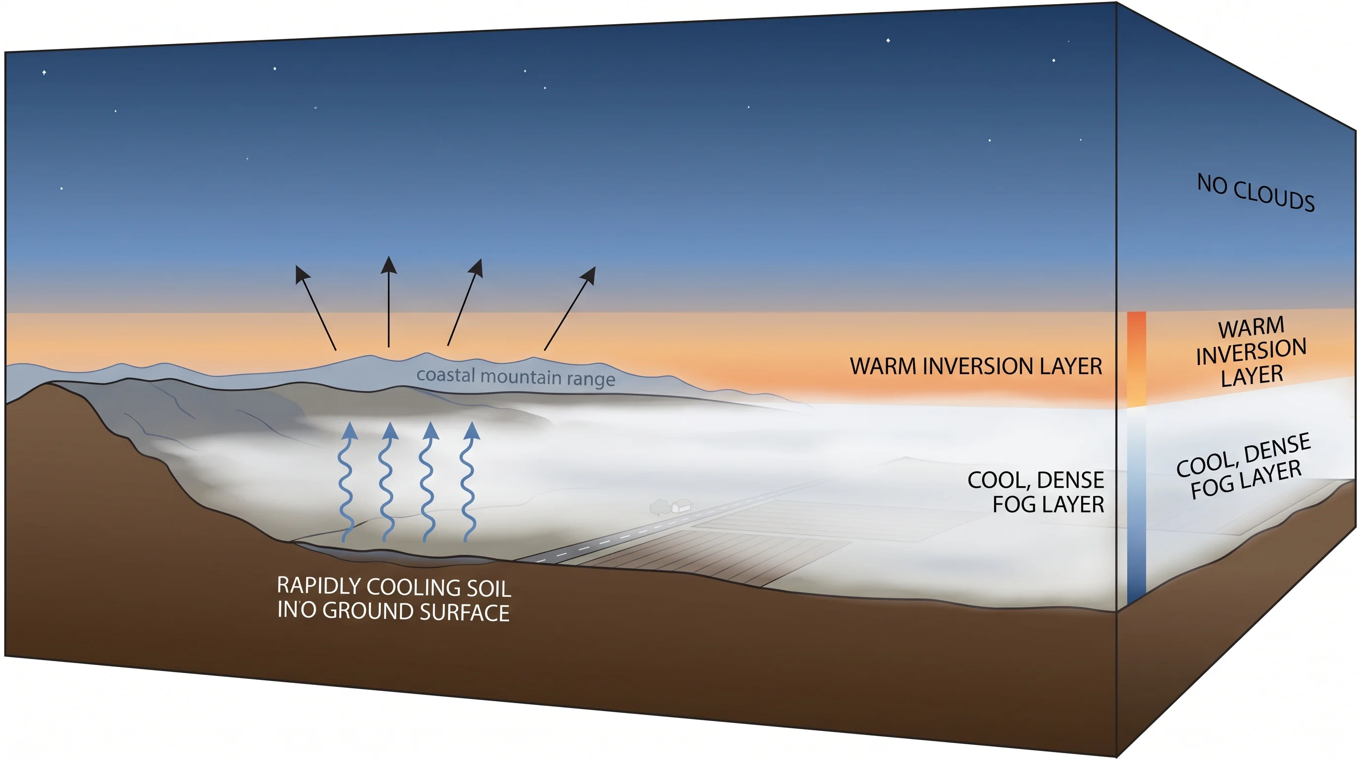
Unlike the marine layer fog that rolls through the Golden Gate and blankets San Francisco, tule fog is a type of radiation fog. It forms over land when the ground cools rapidly on clear, calm nights, chilling the air just above the surface until moisture condenses into fog. Marine fog, by contrast, forms over the cold Pacific Ocean and is pushed inland by onshore winds.
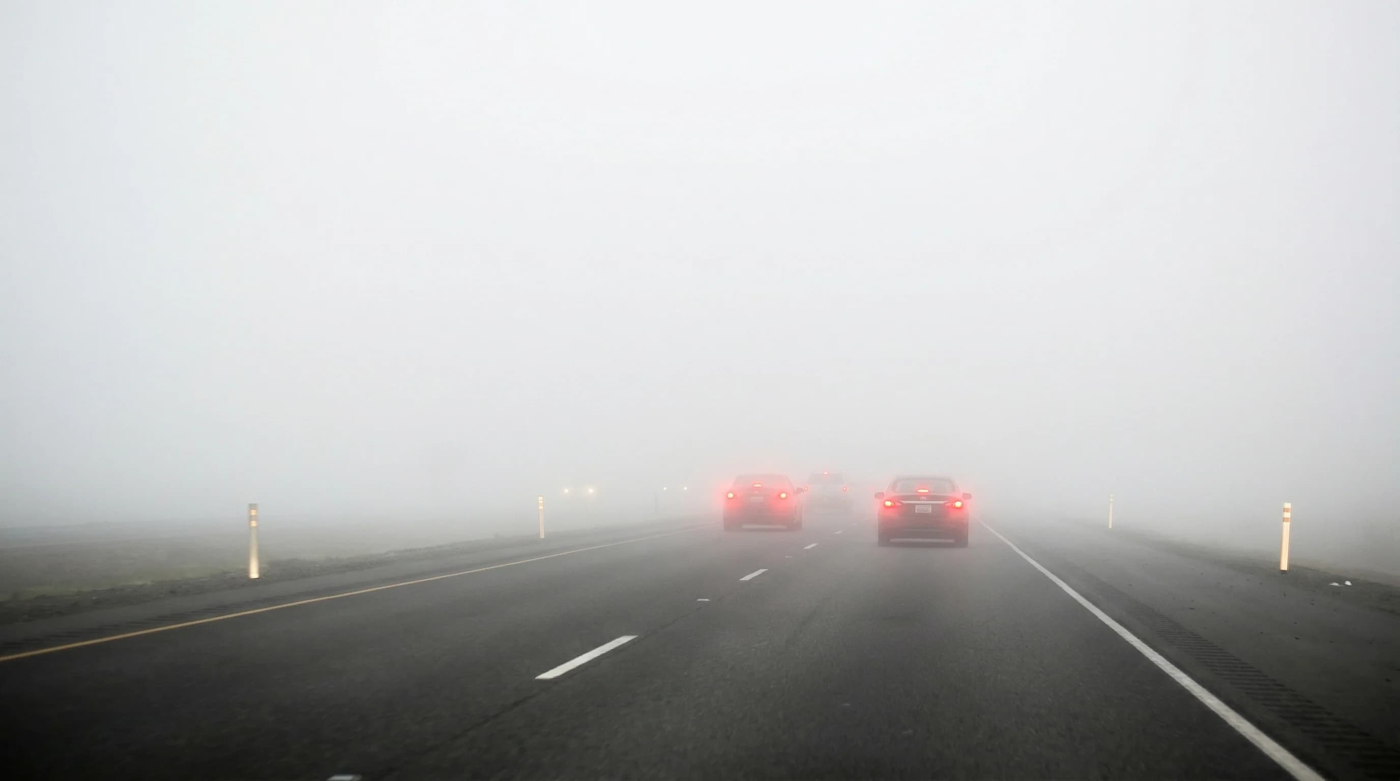
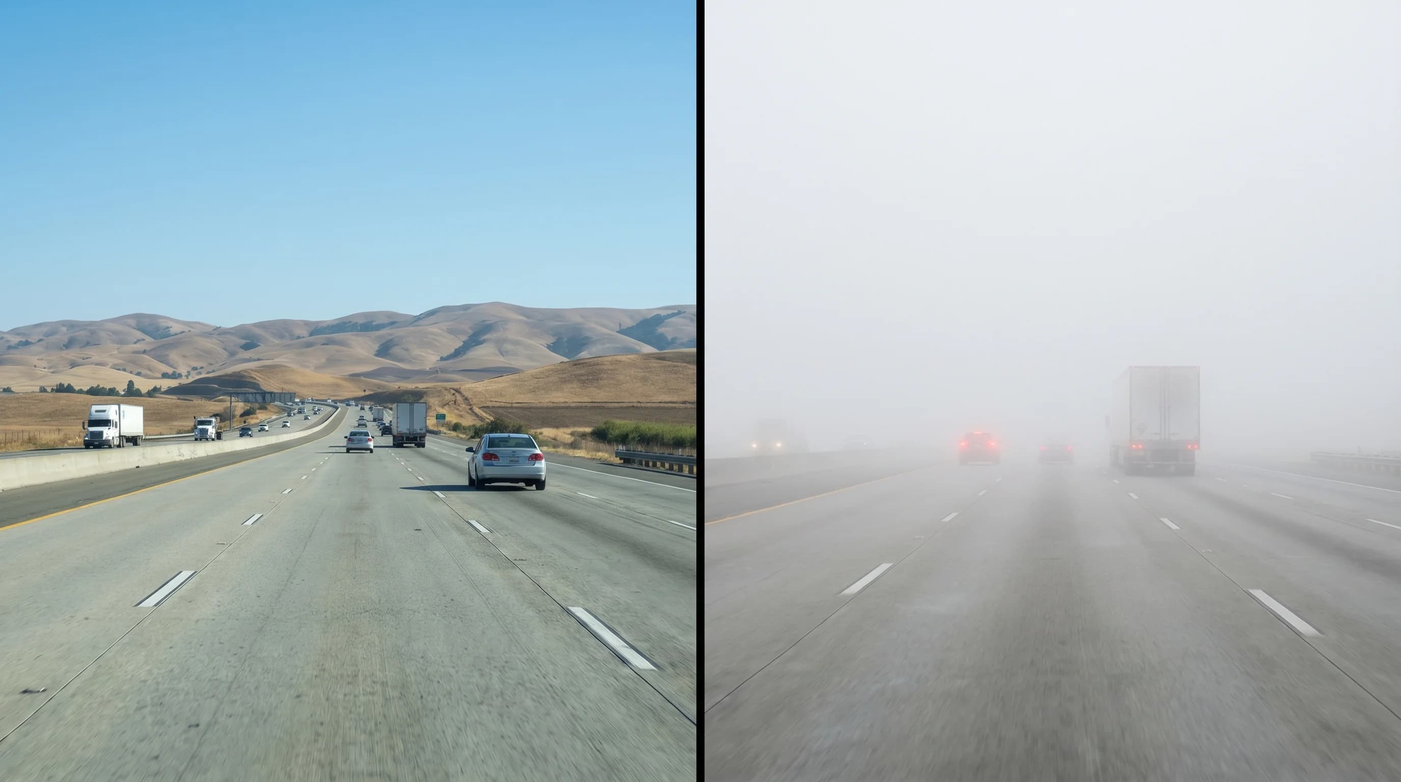
The distinction matters because the two fog types behave very differently. Marine fog typically sits a few hundred feet above the ground and burns off by midday as the sun warms the air. Tule fog hugs the ground, can persist for days or even weeks during strong inversions, and is far denser at its worst. Visibility in tule fog can drop below 10 feet in extreme cases, making it significantly more dangerous for drivers.
Why Is It Called “Tule” Fog?
The name comes from the tule reeds (Schoenoplectus acutus) that once grew abundantly in the marshes and wetlands of California\'s Central Valley. Before large-scale agriculture transformed the valley, vast tule marshes stretched from present-day Sacramento south to Bakersfield. The fog that settled into these low-lying wetlands became known as tule fog, and the name stuck even as most of the marshes were drained for farmland.
Ironically, the agricultural irrigation that replaced those marshes now contributes to tule fog formation. Moist soil from irrigated fields provides the surface moisture that feeds the fog, meaning human activity has in some ways perpetuated the phenomenon even as its namesake habitat has largely disappeared.
How Tule Fog Forms
Tule fog needs a specific set of conditions to develop, which is why it appears almost exclusively between November and March:
- Clear skies at night: Cloud cover acts like a blanket, trapping heat near the ground. On clear nights, heat radiates freely into space, cooling the surface rapidly.
- Light or calm winds: Strong winds mix the air and prevent the cold, moist layer from settling near the ground. Tule fog needs still conditions to form.
- Moist soil: Recent rain or irrigation provides moisture that evaporates into the cooling air. The Central Valley's agricultural landscape provides ample moisture through the winter.
- Temperature inversion: A layer of warmer air aloft traps the cold, foggy air near the surface. The Central Valley's bowl-like geography between the Coast Ranges and the Sierra Nevada naturally creates inversions that can persist for days.
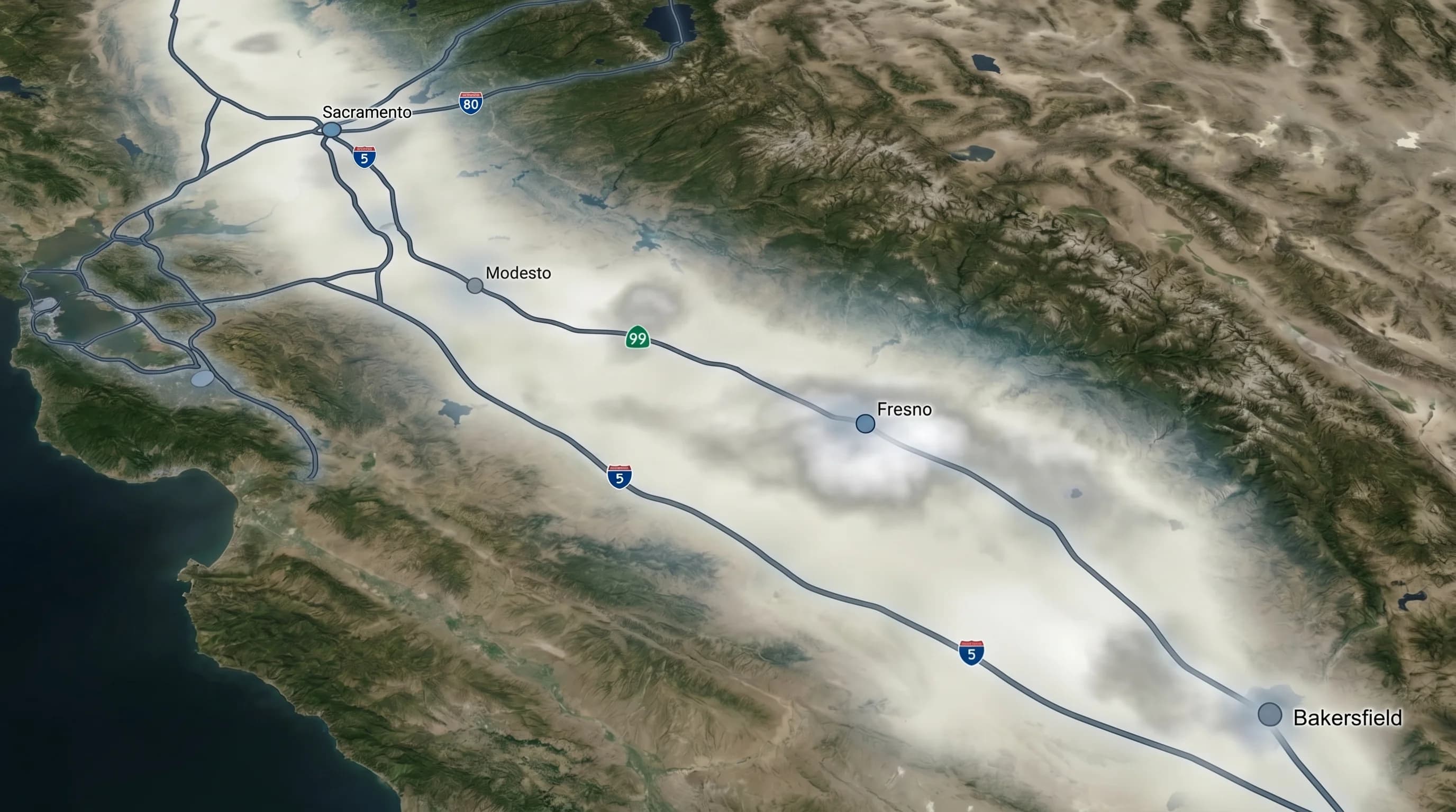
Once these conditions align, fog forms in the lowest-lying areas first, often along river channels and old lake beds, then spreads and deepens overnight. By morning, a continuous fog bank can stretch across the entire valley floor, an area roughly 50 miles wide and 400 miles long.
Tule Fog and the Bay Area
While tule fog is primarily a Central Valley phenomenon, it directly affects parts of the Bay Area. The Carquinez Strait, the narrow water gap where the Sacramento and San Joaquin Rivers flow into San Francisco Bay, acts as a corridor for tule fog to spill westward into the East Bay.
Communities in the eastern reaches of the Bay Area are most affected. Livermore, Brentwood, and Antioch can experience tule fog conditions during strong events, while Concord and Walnut Creek may see reduced visibility as fog pushes through the strait.
The effect is most noticeable during morning commutes. Drivers heading east on Interstate 580 toward the Altamont Pass can go from clear skies in Dublin to near-zero visibility in Livermore within a few miles. The reverse is true in the evening, when tule fog begins forming in the valley and creeps westward.
Tule Fog vs. Bay Area Marine Layer
Bay Area residents are accustomed to fog, but the fog they typically see, the marine layer, behaves nothing like tule fog. Here are the key differences:
- Origin: Marine fog forms over the cold Pacific Ocean. Tule fog forms over land in the Central Valley.
- Season: Marine fog peaks in summer (June through August). Tule fog is a winter phenomenon (November through March).
- Density: Marine fog usually allows visibility of a quarter mile or more. Tule fog regularly drops visibility below 500 feet and can reach near-zero.
- Duration: Marine fog typically burns off by midday. Tule fog can persist for days during strong inversions, sometimes lasting a week or more.
- Altitude: Marine fog often sits above ground level as a stratus layer. Tule fog is ground-level, which makes it more dangerous for travel.
Safety and Driving in Tule Fog
Tule fog is one of the leading causes of weather-related traffic accidents in California. Multi-vehicle pileups on Central Valley highways are tragically common during fog season. The California Highway Patrol issues fog advisories when visibility drops significantly, and several sections of Interstate 5 and Highway 99 have fog-detection systems that trigger warning signs.
If you encounter tule fog while driving, the most important rule is to slow down dramatically. Use low-beam headlights (high beams reflect off the fog and reduce visibility further), increase your following distance, and be prepared for sudden stops. If visibility drops to near zero, pull completely off the road if safely possible. Stopping in a travel lane is extremely dangerous.
Is Tule Fog Declining?
Research from UC Berkeley and other institutions has found that tule fog events have decreased significantly over the past several decades. Studies suggest that tule fog days in the Central Valley have declined by roughly 50% since the 1980s. The primary driver appears to be warmer winter nighttime temperatures associated with climate change, which reduce the radiative cooling needed to trigger fog formation.
While fewer fog days may seem like good news for drivers, tule fog plays an important role in Central Valley agriculture. Many fruit and nut trees, including almonds, walnuts, and cherries, require winter chill hours to produce well, and fog helps maintain the cold temperatures these crops need. Declining tule fog is one of several climate-related challenges facing California agriculture.