Tule fog has historically been California's deadliest weather phenomenon. Not earthquakes, not wildfires, not floods: fog. The dense ground-level fog that settles into the Central Valley each winter has caused more traffic fatalities per event than any other weather hazard in the state's history. In the Bay Area, tule fog is a peripheral concern; it fills the inland valleys of the East Bay and the low points of the North Bay on cold winter mornings, but it dissipates before reaching the coast and rarely achieves the catastrophic density it reaches in the San Joaquin Valley. How it forms, and how it differs from the Bay Area's own winter fog, is the story of one of California's most overlooked and most dangerous weather patterns.
What Makes Central Valley Fog Different
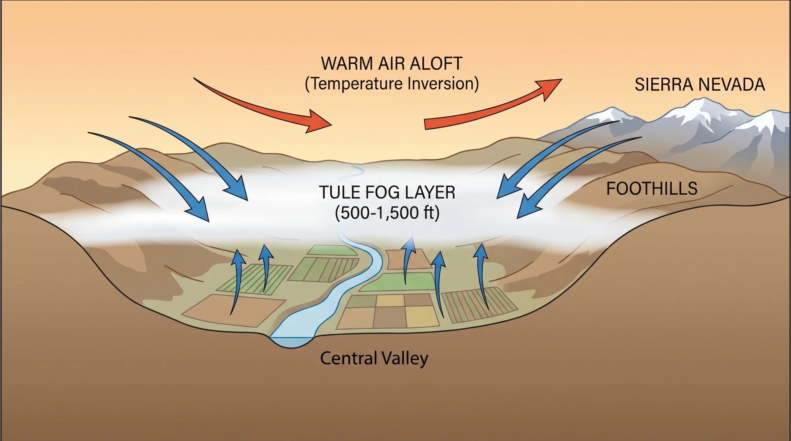
The Central Valley, the broad, flat agricultural corridor running 400 miles from Redding in the north to Bakersfield in the south, is topographically ideal for ground-level fog formation. The valley is essentially a bowl: the Sierra Nevada to the east, the Coast Ranges to the west, and relatively little terrain within the valley itself to mix the air or disrupt cold air pooling. In winter, when skies clear and winds calm after storm systems pass, the valley floor radiates heat to space rapidly. Cold, dense air settles into the bowl and pools in the flat terrain. If the air is already moist from recent rains, the ground cooling brings it below its dew point, and fog forms.
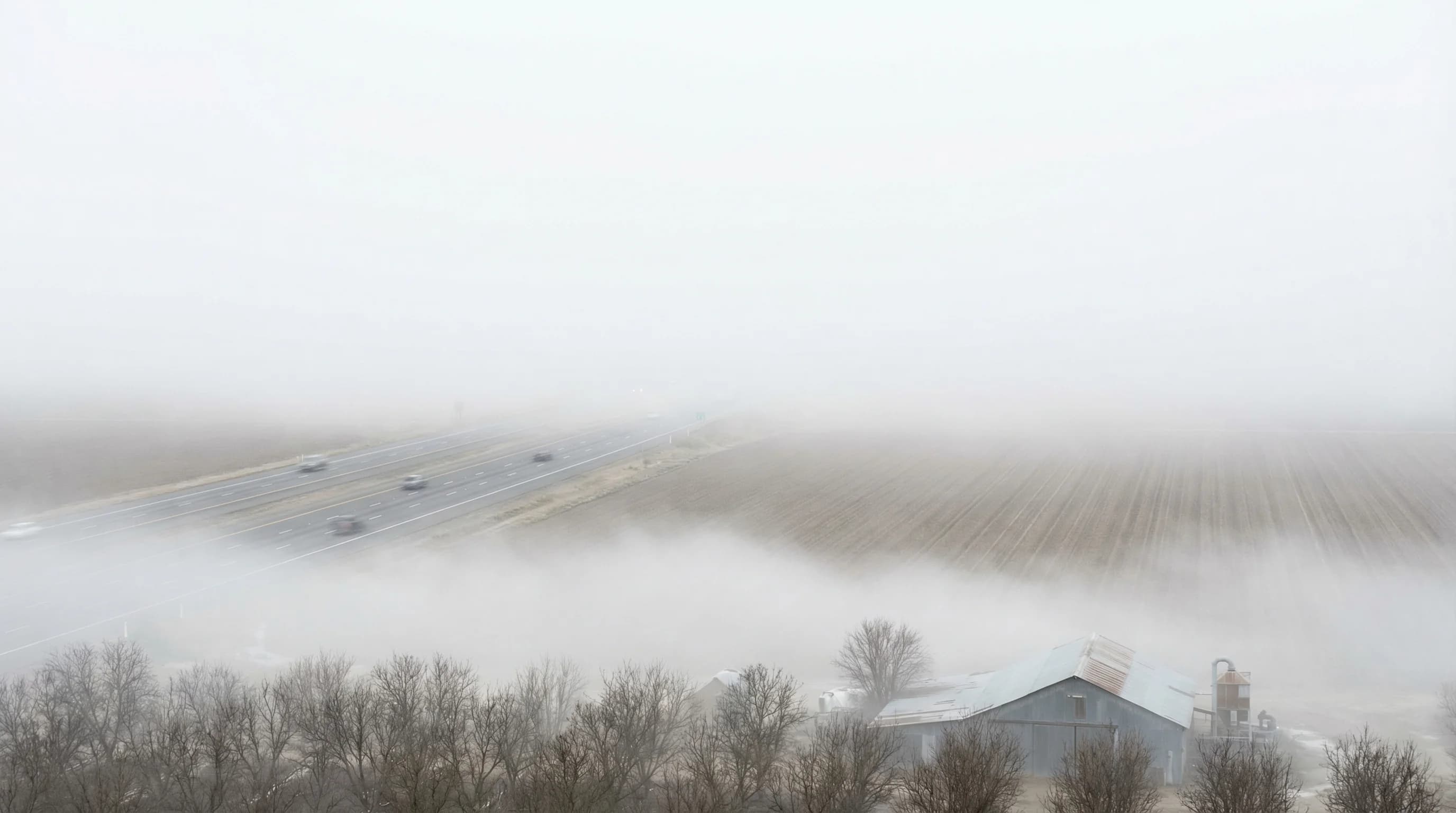
The flatness of the Central Valley is what makes this fog so dangerous. In hilly terrain, cold air drainage creates fog in valleys and hollows, but the terrain also creates variation; you can drive out of a fog pocket by going uphill. In the Central Valley, the fog can be uniformly dense for hundreds of miles in any direction. There is no escape route. Interstate 5 and Highway 99 cut straight through the heart of the tule fog zone, and multi-car pileups during dense fog events, sometimes involving dozens of vehicles, are a recurring winter tragedy.
How Tule Fog Reaches the Bay Area
The Bay Area is partially connected to the Central Valley through the Sacramento-San Joaquin Delta and the Carquinez Strait. During winter high-pressure events that produce Central Valley tule fog, the cold dense air can drain westward through these passages and spill into the East Bay lowlands and the Livermore Valley. The Livermore Valley, Pleasanton, and the Tri-Valley communities closest to the Altamont Pass regularly experience tule fog conditions that originated in the Central Valley and moved westward overnight.
Napa Valley and the Petaluma corridor also receive tule fog through the Carquinez and Petaluma passages. The Napa Valley floor, particularly in the Carneros region, can be fogged in with ground-level tule fog while the surrounding hills are in sunshine, a phenomenon that wine growers know intimately, since frost and fog events in the valley floor in spring can threaten young vine growth.
How Long Tule Fog Lasts
Bay Area marine layer fog and summer coastal fog typically clear within hours of sunrise as solar heating burns through the low cloud layer. Tule fog is different: it can persist for days or even weeks in the Central Valley because the high-pressure system that produced it keeps the air calm, clear aloft, and continuously radiatively cooling the surface. The fog layer is shallow enough that the sun cannot break through from above, and the calm conditions prevent mixing from the sides or above.
Multi-day and multi-week tule fog events are documented in the Central Valley record. Fresno and Bakersfield have experienced stretches where the sun was not visible for two to three weeks at a time, with fog reforming each night before any solar heating could establish itself during the day. The valley cities below the fog layer experience gray twilight conditions throughout these events, not the romantic gray of Bay Area marine layer fog, but a flat, cold, featureless overcast that reduces visibility to near zero on the worst mornings.
In the Bay Area's inland valleys, tule fog events are shorter and less severe. The proximity to the coast means that onshore flow eventually disrupts the persistent high pressure, and the fog dissipates within a day or two. For Bay Area residents who drive over the Altamont Pass or through the Delta into the San Joaquin Valley in winter, the transition from the Bay Area's coastal conditions into a wall of Central Valley tule fog can be abrupt and disorienting. Reducing speed and increasing following distance are not optional precautions; they are the difference between making it through and becoming a statistic.