No, it does not snow in San Francisco in any practical sense. The city has recorded measurable snowfall only a handful of times in its recorded weather history, and the most recent significant event was in February 1976, when a light dusting covered parts of the city for a few hours before melting. San Francisco sits at sea level on a peninsula surrounded by the Pacific Ocean and San Francisco Bay, and that oceanic influence keeps winter temperatures well above freezing almost without exception. The average low in January, the coldest month, is 46 degrees F. The city simply does not get cold enough for snow.
Why San Francisco Does Not Get Snow
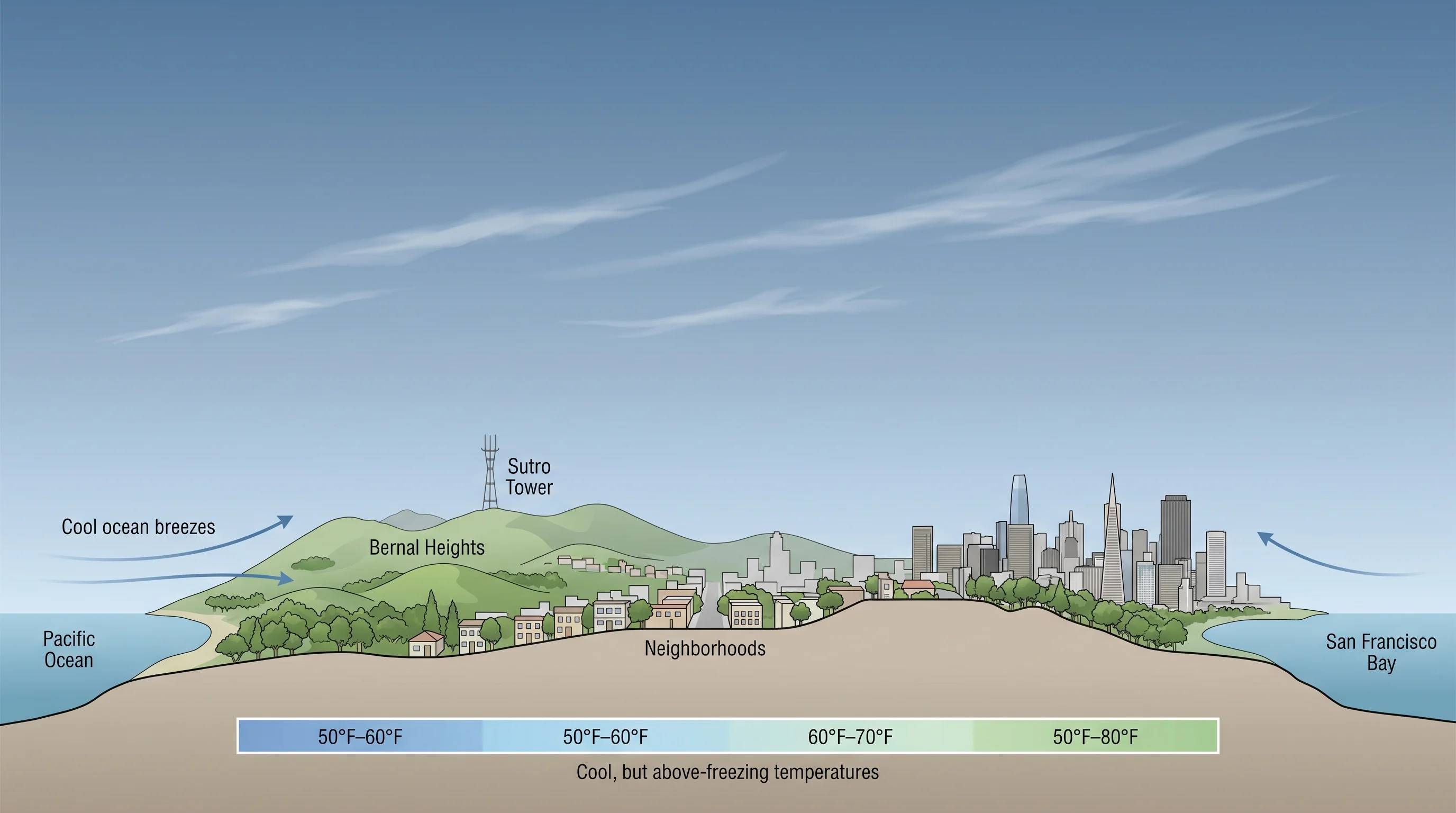
The Pacific Ocean is the primary reason. The California Current, which flows southward along the coast, keeps ocean surface temperatures between 50 and 56 degrees F year-round. That water moderates the air above it, and onshore flow carries that moderated air into San Francisco continuously. Even when cold air masses push south from the Gulf of Alaska, the ocean acts as a thermal buffer, warming the air before it reaches the city. This is the same mechanism that keeps San Francisco cool in summer and mild in winter.
For snow to form, surface temperatures generally need to be at or below 32 degrees F, and the air column above needs to be cold enough to sustain frozen precipitation all the way to the ground. San Francisco's winter temperatures hover in the 46-57 degree F range, which is 15 to 25 degrees too warm for snow. The temperature inversions that are common in the Bay Area winter actually trap warmer air near the surface, making snow even less likely at sea level.

The February 1976 Snowfall
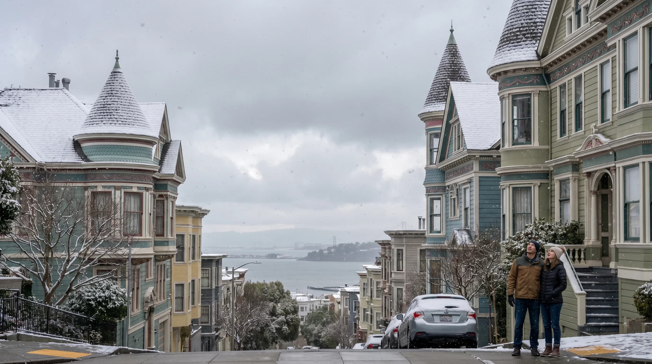
The most famous snow event in San Francisco history occurred on February 5, 1976, when an unusually cold air mass pushed surface temperatures below 35 degrees F and produced light snow across the city. Residents woke to a thin coating of snow on car hoods, rooftops, and the higher elevations of Twin Peaks and Mount Sutro. The snow did not last long. By late morning, rising temperatures had melted it completely. Photographs from that day show people throwing snowballs in Golden Gate Park, a scene so unusual it made national news.
Before 1976, the most notable San Francisco snowfall was in January 1962, and before that, December 1932. These events are spaced decades apart, which underscores how unusual the conditions need to be for snow to reach sea level in the Bay Area. Each event required a rare combination of a strong cold air mass from the interior, clear skies overnight for maximum radiative cooling, and moisture arriving at just the right moment as temperatures bottomed out.
Where to See Snow Near San Francisco
While San Francisco itself does not get snow, you can see snow-dusted peaks from the city on rare winter mornings. Mount Diablo (3,849 feet) and Mount Tamalpais (2,571 feet) both receive occasional dustings of snow during the coldest storms. Mount Hamilton (4,265 feet) above San Jose gets snow several times most winters. These events typically occur when the snow level, the elevation at which precipitation transitions from rain to snow, drops below 3,000 feet, which happens a few times per winter during the strongest cold storms.
For reliable snow within a few hours of San Francisco, the Sierra Nevada is the destination. Lake Tahoe and the ski resorts along Interstate 80 and Highway 50 are about four hours east, and they receive an average of 300-500 inches of snow per winter. The contrast is remarkable: San Francisco can be 55 degrees and rainy while Donner Summit, 200 miles away, is buried under 10 feet of snow from the same storm system.
How Cold Does San Francisco Actually Get?
San Francisco's all-time record low is 27 degrees F, set on December 11, 1932. That is the only time the city has recorded a temperature below 30 degrees at an official weather station. For context, the average January low is 46 degrees F, and temperatures below 40 degrees are rare enough to make the local news. The coldest Bay Area temperatures occur inland, in valleys like Livermore and Santa Rosa, where the absence of oceanic influence allows temperatures to drop much lower on clear, calm nights.
The wind chill effect can make San Francisco feel colder than the thermometer reads, particularly in the fog-prone western neighborhoods. A 50-degree day with 20 mph wind and fog moisture feels much colder than 50 degrees in calm, dry air. This is why layering is essential for San Francisco winters, even though the actual temperature readings are mild by national standards.
Will Climate Change Make Snow Even Less Likely?
Climate projections for the Bay Area indicate continued warming, which makes the already remote possibility of San Francisco snowfall even more unlikely in the decades ahead. Average winter temperatures in the city have risen roughly 2 degrees F since the mid-20th century, pushing the cold end of the temperature distribution further from the freezing mark. The snow level during winter storms is also rising on average, meaning that even the nearby peaks that occasionally see dustings may receive less snow over time.
San Francisco is a city where 60-degree winters feel cold to residents and 55-degree summer fog draws complaints. The idea of snow is charming precisely because it almost never happens. If you want to experience snow in Northern California, the Sierra Nevada is the place. If you want to experience San Francisco's version of winter, bring a rain jacket and layers, not a snow shovel.