Snow in the Bay Area is rare enough to be an event. When it happens, it makes the news, schools let out early, and thousands of Bay Area residents drive up to the hills to see something they might only witness a handful of times in their lives. It is not mythical, though. Snow falls in the Bay Area most winters, just not where most people live. The summits of Mount Diablo, Mount Tamalpais, and the higher Santa Cruz Mountains receive light snow several times per decade, and the peaks above 3,000 feet can see measurable accumulation in the right storm. Once you know the conditions that produce it, Bay Area snow goes from surprising to predictable and plannable.
Where Snow Falls in the Bay Area
Elevation is everything when it comes to Bay Area snow. The region's mild marine climate keeps temperatures warm enough at sea level that snow almost never reaches valley floors or urban neighborhoods. But the Bay Area's highest peaks rise well above the elevation where winter storm temperatures routinely drop below freezing, and snow is the result.
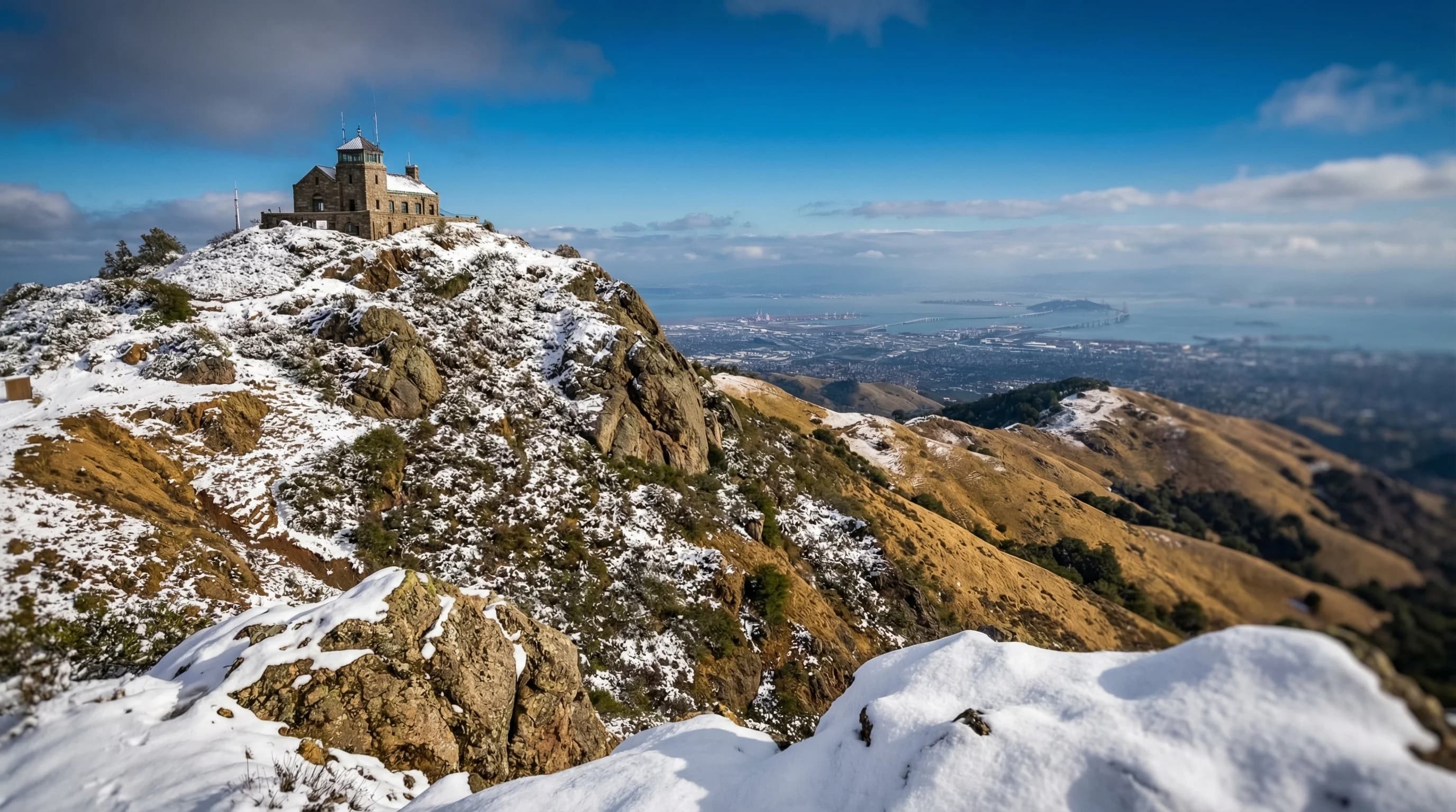
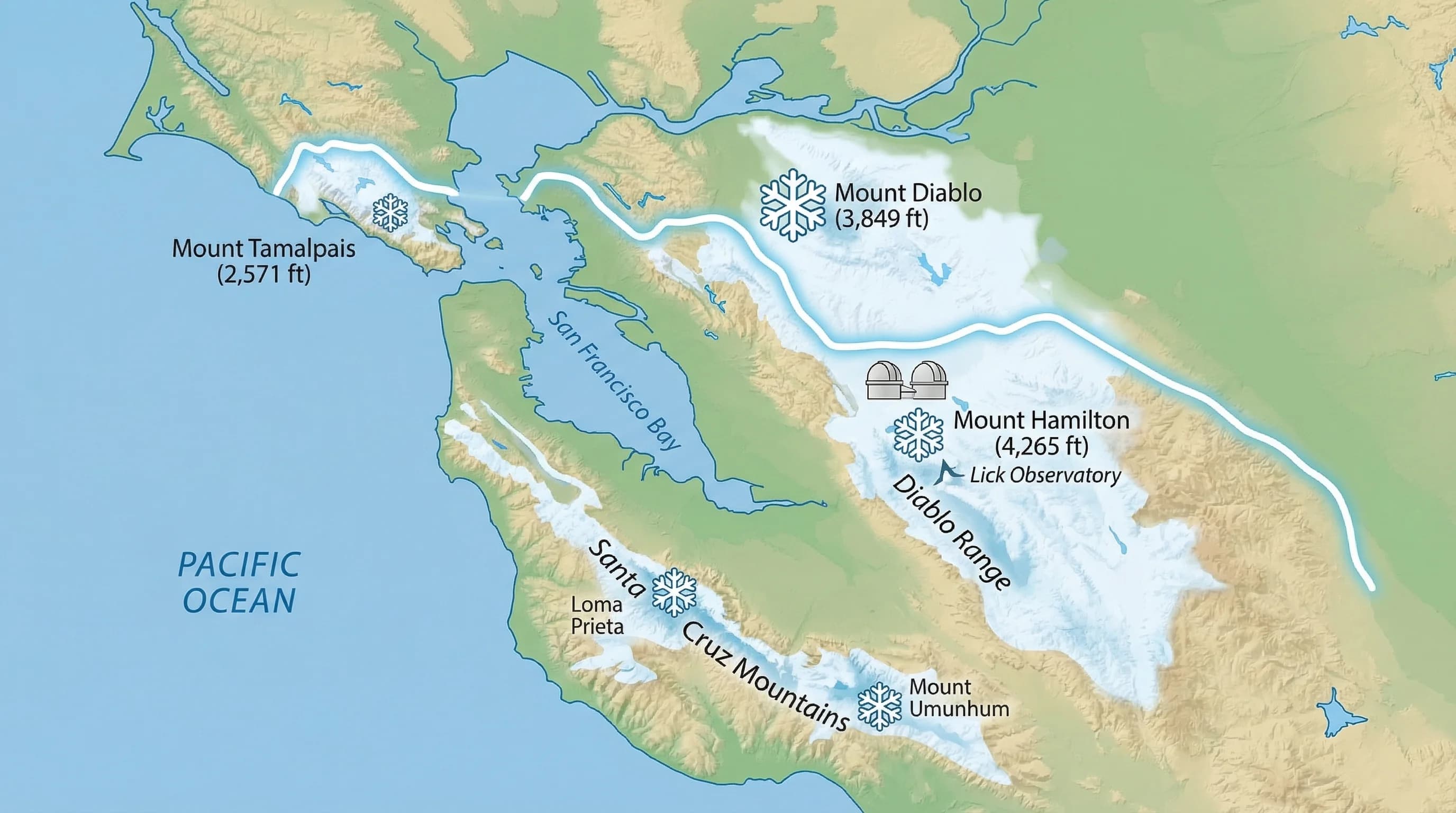
Mount Diablo (3,849 feet) is the Bay Area's most accessible snow destination and the most frequently visited when snow falls. Its summit is visible from much of the East Bay and is only about an hour's drive from Oakland and San Jose. When a strong winter storm drops the snow level to 3,000 feet, the summit and upper slopes receive accumulation. Mount Diablo State Park typically sees measurable snow once every one to three winters, with lighter dustings more frequently. The summit road closes during and after snowfall for safety, which is worth checking before you make the trip.
Mount Tamalpais (2,571 feet) in Marin County receives light snow or graupel during particularly cold winter storms, though accumulation is rarer than at Mount Diablo due to the lower summit elevation and the moderating effect of the nearby Pacific. The East Peak and West Peak can see a dusting when cold Arctic air dips unusually far south.
The Santa Cruz Mountains, specifically the ridgelines above 2,500 feet near Ben Lomond Mountain and the area around Loma Prieta (3,791 feet), receive the most reliable Bay Area snowfall. The Santa Cruz Mountains sit directly in the path of Pacific storms and receive more precipitation than any other Bay Area range. Loma Prieta, the highest point in the Santa Cruz Mountains, can accumulate several inches during strong cold storms. However, road access to these summits is limited and not designed for tourist snow visits the way Mount Diablo is.
Hamilton (4,265 feet), the highest peak in the Diablo Range and site of Lick Observatory, is the most likely place to see snow in the Bay Area. At over 4,200 feet, it receives snow more frequently than any of the lower peaks. The road to Lick Observatory closes during and after snowfall. When it reopens, the views from the summit over a snow-dusted Bay Area can be spectacular.
How Often Does It Snow in the Bay Area?
At summit elevations, snow is not as rare as Bay Area residents often think. Mount Diablo's summit receives some form of frozen precipitation, including graupel, snow pellets, or measurable snow, roughly once every one to three winters on average. Significant accumulations of several inches happen perhaps once per decade at the summit. The Santa Cruz Mountains above 3,000 feet see similar or slightly higher frequency given their greater precipitation exposure.
At lower elevations, snow is genuinely unusual. Communities below 1,000 feet in the hills, such as the Oakland Hills, Berkeley Hills, and the Marin Highlands above 1,500 feet, see a trace or light dusting perhaps once per decade. Valley floors and urban areas at sea level receive snow only during extremely cold air mass intrusions. The last time downtown San Francisco received measurable snow was February 5, 1976, when 0.4 inches fell. Before that, a significant snowfall occurred in January 1962. Historical snow events in San Francisco proper are rare enough that each one is individually documented and remembered.
What Conditions Produce Bay Area Snow?
Bay Area snow requires a specific atmospheric setup that does not happen every winter. The Pacific Ocean keeps the region mild, and most winter storms deliver rain rather than snow even in the hills because air temperatures remain above freezing through most of the storm column. Snow requires one of two setups.
The first is a cold Arctic air mass pushing down from the north or northeast before or during a storm. When a surface high pressure system sits over the Great Basin and cold continental air flows into California from the north, temperatures drop to the point where storm precipitation falls as snow at elevations well below the normal snow level. These "cold air" snow events are responsible for most of the historic low-elevation snowfall in the Bay Area, including the rare downtown San Francisco events.
The second is a very cold, upper-level trough that drops the freezing level in the atmosphere to below 2,500 to 3,000 feet during an active storm. This is the more common mechanism for summit snowfall at Mount Diablo and the Santa Cruz Mountains. When the snow level drops during an incoming Pacific storm, precipitation that would normally fall as rain at these elevations comes down as snow. The snow level, a term you will hear in Bay Area winter weather forecasts, is the critical number to watch: when it drops below 3,000 feet, snow at the Bay Area peaks is likely.
Notable Historical Bay Area Snow Events
The winter of 2023 brought remarkable snow to Bay Area summits as part of the same bomb cyclone sequence that broke rainfall records. In February and March 2023, cold storms drove snow levels down to around 2,500 feet multiple times, dusting Mount Diablo, coating the Santa Cruz Mountains, and bringing snow to Oakland Hills neighborhoods above 1,500 feet. The visual of snow on the ridgelines above the Bay was widely photographed and was the most accessible Bay Area snow event in years.
The January 1962 storm remains the most memorable low-elevation snow event in Bay Area history. Snow fell across much of the Bay Area below 500 feet, reaching downtown San Francisco, Oakland, and San Jose. Accumulations of 3 to 5 inches were reported in some East Bay and South Bay communities. The event was exceptional enough that it is still referenced by longtime residents as a benchmark.
In February 1976, a brief cold air intrusion brought a trace to 0.4 inches of snow to downtown San Francisco, the most recent measurable snowfall in the city proper. The event lasted only a few hours and melted quickly, but photographs from that morning circulate regularly as evidence that San Francisco does occasionally see snow.
Tips for Visiting Bay Area Snow
When snow falls on Mount Diablo, it generates enormous public interest and significant traffic on the summit road. East Bay Regional Parks and California State Parks manage access carefully. The Mount Diablo summit road and upper sections typically close during snowfall and reopen once the road is deemed safe, which can be several hours to a day after the storm. Check the Mount Diablo State Park website or California State Parks social media before driving up.
Carry chains or have AWD/4WD and all-season tires if driving to any Bay Area summit after a snow event. Even light snow on unfamiliar mountain roads is dangerous for drivers without experience. Bring warm layers: summit temperatures during and after a Bay Area snowstorm can be in the mid-20s to low 30s with wind chill, dramatically colder than the valley below. The novelty of Bay Area snow attracts crowds with little cold-weather preparation, so warm clothing and sturdy footwear are important.
The best strategy is to track the snow level forecast in the days before a major winter storm. When the National Weather Service Bay Area office forecasts a snow level below 3,000 feet for the East Bay or South Bay mountains, Mount Diablo and Hamilton are likely to receive accumulation. Check SFBayWeather for current conditions at mountain destinations, and monitor the Mount Diablo State Park website for road closure updates.