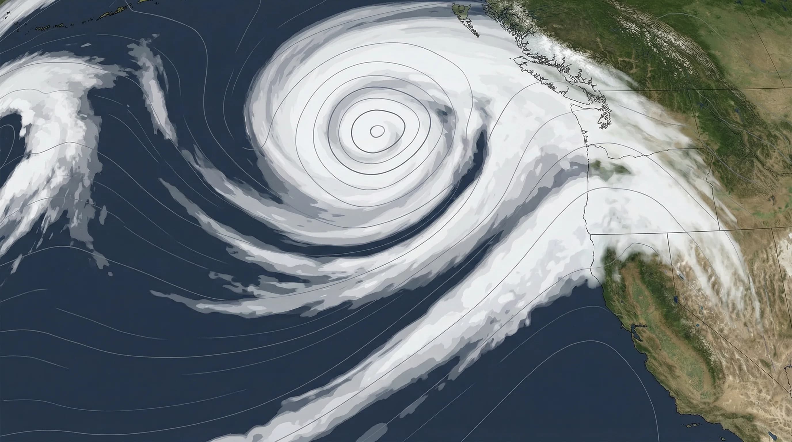
"Bomb cyclone" is not a made-up term designed to terrify weather forecast audiences. It is a real meteorological phenomenon with a specific technical definition: a mid-latitude cyclone whose central pressure drops at least 24 millibars in 24 hours, a process called bombogenesis. When this happens, the storm intensifies at a rate that catches many weather systems off-guard, and the results for coastal regions like the Bay Area can be dramatic: atmospheric rivers supercharged with moisture, winds gusting to 70 or 80 miles per hour, and rainfall totals that compress months of precipitation into a day or two.
What Is a Bomb Cyclone? The Science of Bombogenesis
A cyclone is simply a low-pressure weather system. Mid-latitude cyclones, the type that bring winter storms to the Bay Area, form when cold polar air collides with warm subtropical air along boundaries called fronts. The pressure difference between the two air masses spins up a rotating low-pressure system. Normal winter cyclones strengthen over days as they develop. A bomb cyclone strengthens in hours.
The technical threshold for bombogenesis is a pressure drop of 24 millibars in 24 hours at 60 degrees North latitude, adjusted for lower latitudes where the Coriolis effect is weaker. At 38 degrees North, which is approximately California's latitude, the threshold is roughly 17 to 18 millibars in 24 hours. The rate of pressure fall is what defines the phenomenon: faster pressure drop means faster wind acceleration, more intense fronts, and heavier precipitation.
Bomb cyclones that affect California typically develop in the North Pacific, often between 1,500 and 3,000 miles offshore. Warm ocean temperatures in certain Pacific regions provide the energy that allows rapid intensification. When the jet stream is positioned to steer these storms toward Northern California, the Bay Area can receive the direct impact of a storm that was significantly weaker just 24 hours earlier than forecast.
How Bomb Cyclones Affect the Bay Area
Bomb cyclones do not always hit the Bay Area directly. Often they stay offshore and wrap moisture-laden atmospheric river plumes into California without making direct landfall. In these cases, the primary impact is enhanced rainfall, as the atmospheric river feeding the storm delivers exceptional moisture content to the coast. When the January 2023 atmospheric river sequence struck California, bomb cyclone development offshore amplified the storm's intensity and contributed to record-breaking rainfall totals across Northern California.
When a bomb cyclone does approach closer to the Bay Area, the wind impacts become significant. The tightest pressure gradients, where wind speeds are highest, occur near the center of the storm and along its frontal boundaries. Cold fronts associated with intense cyclones can bring wind gusts of 50 to 80 miles per hour to coastal and elevated Bay Area locations. Marin Headlands, Point Reyes, and the Santa Cruz Mountains are particularly exposed to these frontal wind events.
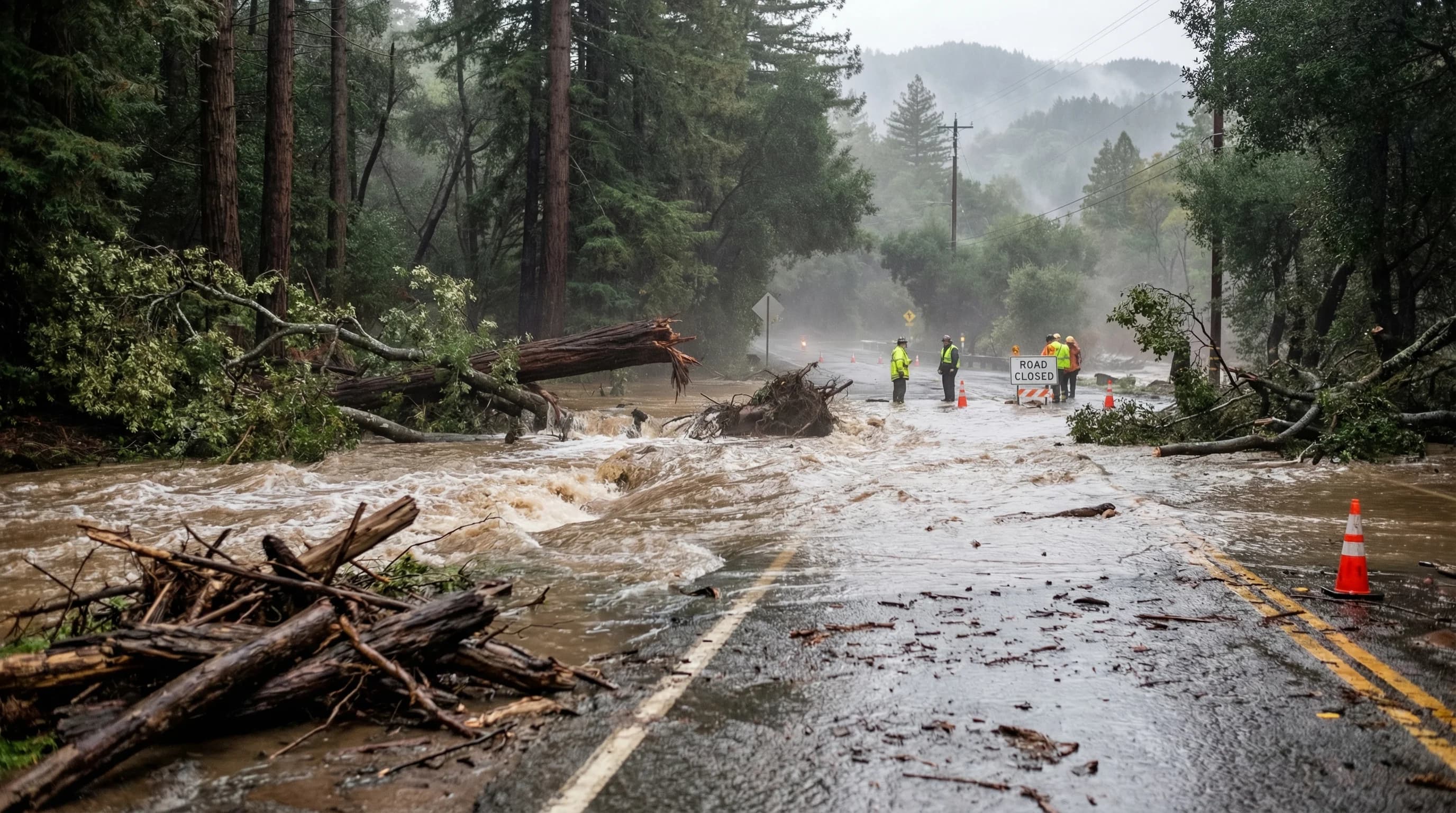
Rainfall from bomb cyclone events tends to be intense and sustained. The storm's enhanced circulation draws a broader and more moisture-laden atmospheric river inland compared to weaker winter storms. The combination of intense frontal rainfall, followed by post-frontal shower activity, can deliver 4 to 8 inches of rain in 24 hours to coastal ranges and watersheds already saturated from earlier storms. This is the flooding risk scenario that Bay Area emergency managers watch most closely during winter.
Notable Bomb Cyclones Affecting the Bay Area
The winter of 2022-2023 brought a series of bomb cyclone events that collectively set rainfall records across California. Between December 2022 and March 2023, a succession of rapidly intensifying Pacific storms delivered more than 200 percent of normal precipitation to parts of the Bay Area. Individual events brought 48-hour rainfall totals that exceeded what the Bay Area normally receives in an entire month. Downtown San Francisco recorded its wettest January in more than 170 years of record-keeping during this period.
The January 2023 atmospheric river sequence was particularly driven by bomb cyclone dynamics. A series of storms rapidly deepened in the North Pacific before turning southeast toward Northern California, each delivering intensified precipitation ahead of their cold fronts. The storms caused widespread flooding, landslides, and debris flows in the Santa Cruz Mountains, Highway 1 closures, and temporary closure of dozens of roads in Marin County.
Earlier notable events include the storms of 2016-2017, when Northern California emerged from a severe drought as a series of intense Pacific storms brought exceptional snowpack to the Sierra Nevada. The Oroville Dam crisis in February 2017 was partly the result of these repeated storm systems delivering rainfall faster than dry, fire-scarred watersheds could absorb it.
Can You Predict a Bomb Cyclone?
Modern numerical weather prediction models have become reasonably skilled at identifying the conditions that favor bombogenesis, typically 3 to 5 days in advance. The European Centre for Medium-Range Weather Forecasts model and the National Weather Service's Global Forecast System both track the pressure evolution of Pacific storms and can often identify bomb cyclone potential before the rapid intensification begins. But the timing and track of these storms remain less certain than their intensity, and a small shift in storm track can mean the difference between a catastrophic Bay Area event and a more routine storm.
Watch for these signals in Bay Area weather forecasts during winter months. A "major Pacific storm," "potent storm system," or references to an "atmospheric river" being enhanced by a deepening low offshore are all indications that bombogenesis may be occurring. The National Weather Service Bay Area office issues High Wind Warnings and Flood Watches well in advance of these events and is the authoritative source for storm preparation guidance.
Preparing for Bomb Cyclone Impacts in the Bay Area
Bay Area residents in flood-prone areas, on hillsides susceptible to landslides, or in homes with large trees should pay close attention to winter storm forecasts from November through March. The key preparedness actions are the same for any major winter storm: clear gutters and storm drains, have emergency supplies ready, know your flood zone status, and identify alternative routes if your primary road is likely to flood.
For travelers, the most common bomb cyclone impact is Highway 1 closures along the San Mateo and Sonoma coasts, where wave action and cliff erosion are intensified by the storm swell that precedes major Pacific systems. Interstate 80 over the Donner Summit can close during the heaviest Sierra Nevada snowfall associated with these storms. Checking Caltrans road conditions before any major Bay Area trip during a winter storm event is essential.
Use SFBayWeather to track comfort scores and conditions across the Bay Area during storm events. During a bomb cyclone-influenced storm, the dramatic weather differences between coastal areas experiencing the worst impacts and inland valleys seeing heavy but more manageable rainfall will be clearly visible in the regional weather data.