In December 2023, a pair of storms stacked back to back and dropped 6 to 10 inches of rain across the Bay Area in 48 hours. Alameda Creek jumped its banks in Fremont and Milpitas. Roads flooded in Santa Cruz County. Hillside neighborhoods across the East Bay went under voluntary evacuation orders as saturated soil on steep slopes started moving. None of this was unusual in any historical sense. It was a strong atmospheric river event, and the Bay Area has been dealing with them since long before anyone had a name for what was happening. Atmospheric rivers are the single most important piece of weather knowledge for living in this region.
How Do Atmospheric Rivers Actually Hit the Bay Area?
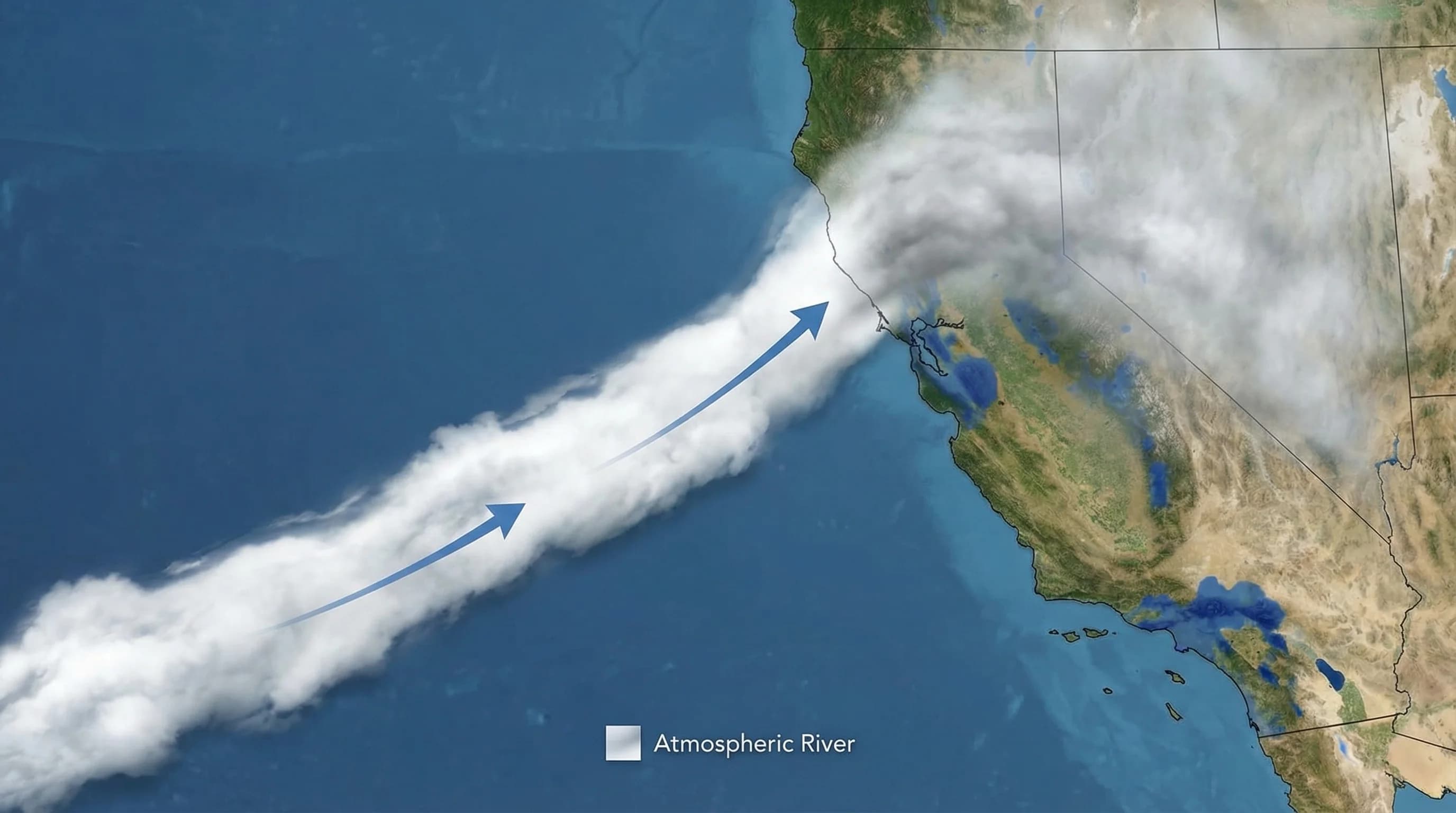
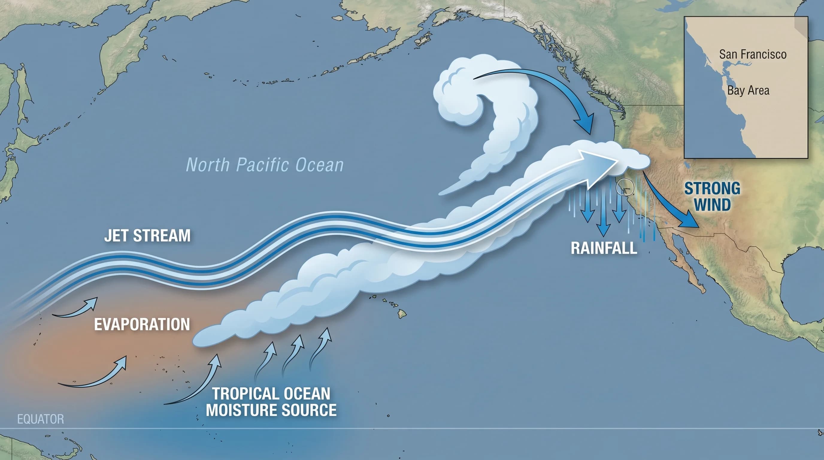
An atmospheric river is a long, narrow band of concentrated water vapor moving through the lower atmosphere. When meteorologists describe it as a “river,” that is not a metaphor: these systems carry more water vapor than the Amazon River carries liquid water. They originate over warm ocean water, typically in the tropics or subtropics, where evaporation loads the air with moisture. The jet stream then channels that moisture across the Pacific toward the California coast.
What makes the Bay Area particularly vulnerable is terrain. When an atmospheric river makes landfall here, it runs straight into the coastal ranges and then the Sierra Nevada. The moist air is forced to rise rapidly, and rising air cools. Cooling air cannot hold as much vapor, so the moisture condenses and falls as rain, sometimes at rates of half an inch per hour or more. The coastal hills of Marin and the Santa Cruz Mountains act like enormous rain concentrators. A storm that drops 3 inches on downtown San Francisco might drop 8 inches on the ridges above Woodside or Fairfax in the same time window.
Which Parts of the Bay Are Most at Risk?
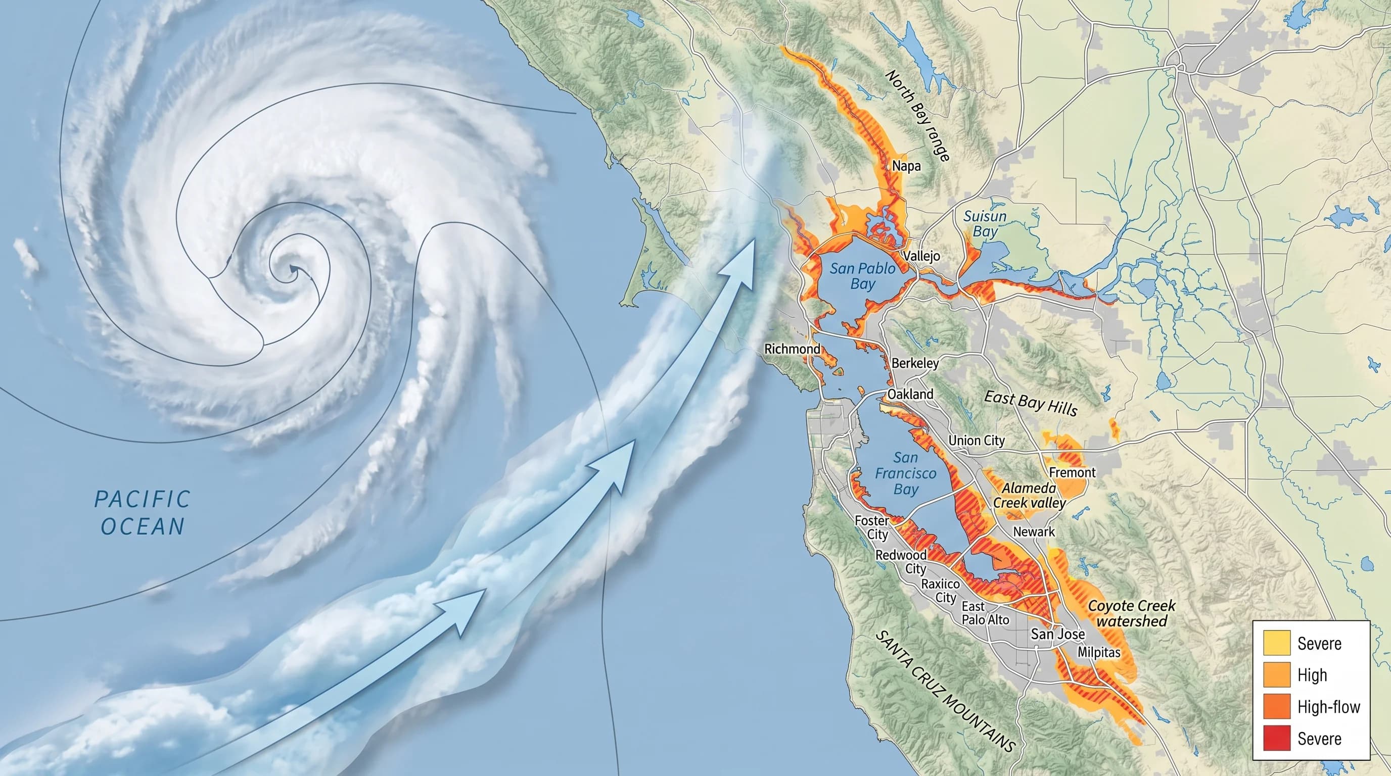
Flood risk in the Bay Area is highly localized, and the geography is fairly predictable once you understand it. Areas at the mouth of creek drainages are the classic high-risk zone: heavy rainfall upstream runs down into low-lying flatlands, where the receiving creek or storm drain system simply cannot move the water fast enough. Alameda Creek, which drains a large swath of the Diablo Range before emptying into the bay near Fremont, floods repeatedly under this dynamic. So does San Mateo Creek in San Mateo County, and so do smaller drainages through Oakland and Berkeley.
The Bay shoreline itself is a second category of risk. When heavy rainfall coincides with high tide and a westerly wind pushing bay water inland, the combination can flood areas that individual factors alone would not reach. South Bay communities around Alviso and East Palo Alto have experienced this multiple times. The Salinas River basin further south floods periodically as well, affecting agricultural lands and communities that sit at low elevations in the river plain.
Hillside neighborhoods carry a different risk profile. Oakland Hills, the ridgeline communities of Marin County, and areas along the Santa Cruz Mountains face landslide and debris flow risk when soils become fully saturated after extended rainfall. A large atmospheric river event that follows several smaller storms is the most dangerous combination, because the soil is already wet when the major rainfall arrives. Landslide risk maps from the USGS are publicly available and worth reviewing if you live in one of these areas.
How Much Rain Falls During a Strong Event?
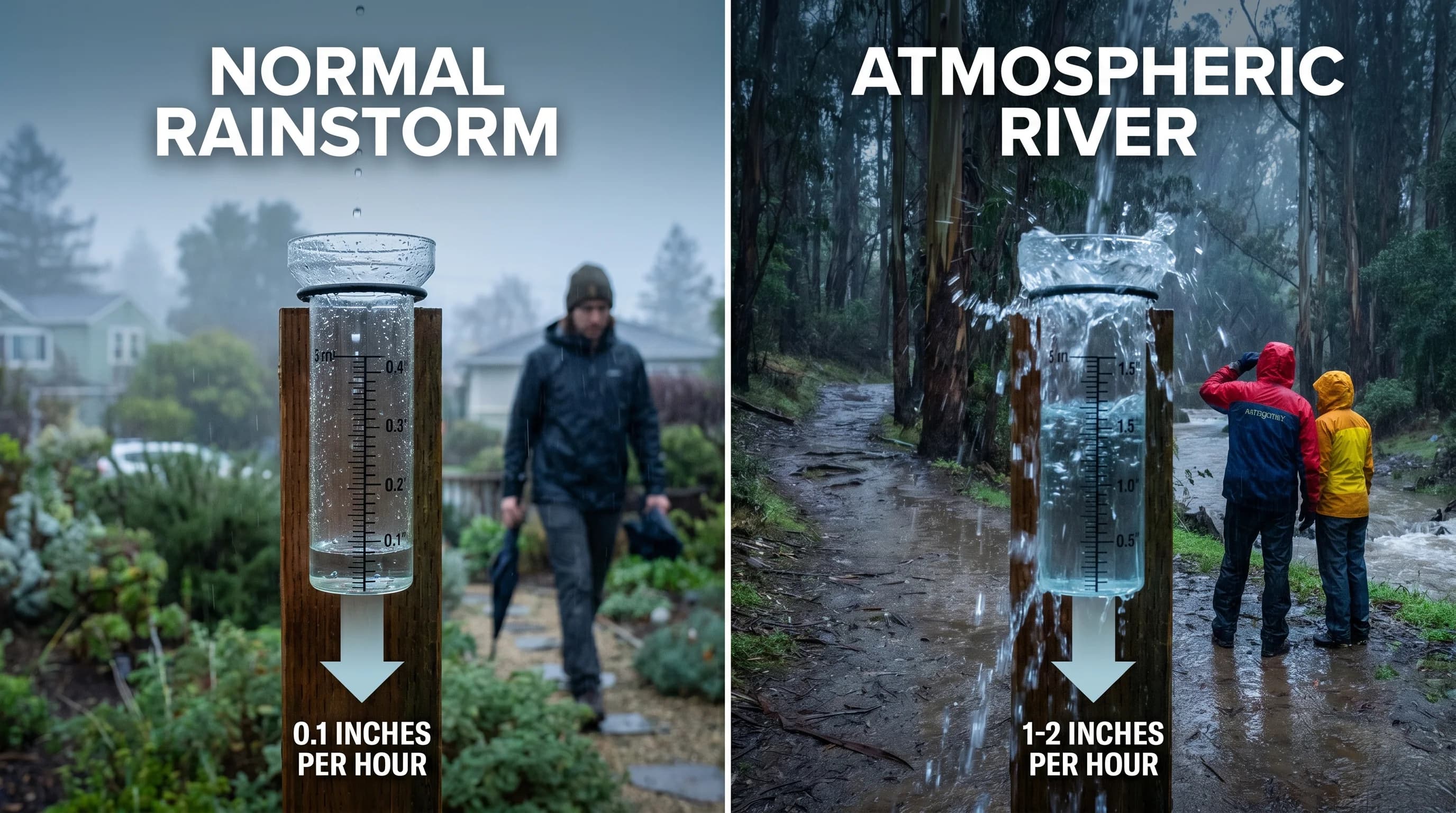
The rainfall totals during a significant atmospheric river event are real enough to surprise people who did not grow up in California. A Category 3 event, which is a moderate-to-significant storm by the official five-tier scale developed at UC San Diego's Center for Western Weather and Water Extremes, typically produces 3 to 6 inches of rain at Bay Area weather stations over 24 to 48 hours. A Category 4 event pushes that to 5 to 10 inches. Category 5 events are exceptional storms that have produced 10 to 15 inches in some Bay Area locations.
What matters as much as total rainfall is rate. Five inches spread over three days gives drainage systems time to move the water through. Five inches in six hours overwhelms everything: storm drains back up, creeks rise faster than evacuation orders can be issued, and soil saturation hits a threshold that triggers rapid runoff instead of absorption. The December 2023 event was notable not just for its total but for arriving in two concentrated pulses, giving the ground no recovery time between rounds.
How the Jet Stream Determines Who Gets Hit
Not all atmospheric rivers hit the Bay Area. The jet stream, which is the high-altitude river of air that steers weather systems across the Pacific, determines where an atmospheric river makes landfall. When the jet stream dips toward the California coast and channels moisture from the subtropics, the Bay Area gets drenched. When the jet stream is positioned further north, the rain falls on Oregon and Washington while California stays dry. When it is further south, Southern California takes the hit.
This steering mechanism is why California winters are so variable. A winter where the jet stream repeatedly hits Northern California produces flooding and a full reservoir system. A winter where it consistently tracks too far north produces drought. Forecasters can predict jet stream positioning reasonably well out to about 7 to 10 days, which is why atmospheric river events now come with meaningful advance warning. The mechanics of that prediction have improved dramatically in the last two decades, driven largely by research into California\'s flood patterns.
Climate Change and the Future of Bay Area Flooding
The physics of climate change and atmospheric rivers is straightforward: for every 1 degree Celsius of warming, the atmosphere can hold approximately 7 percent more water vapor. The tropical Pacific is warming. That means the atmospheric rivers that tap tropical moisture sources are carrying more water than they carried 30 years ago, and they will carry more still as warming continues. A Category 3 event today is likely more intense than a Category 3 event in 1990, even if the two events are otherwise structurally similar.
Researchers also note that California precipitation patterns are shifting toward fewer, more intense events with longer dry spells between them. This is sometimes described as “weather whiplash”: the state swings between drought and flood more abruptly, and the flood events are larger when they arrive. For Bay Area flood control infrastructure built to historical standards, this trend represents a genuine design challenge. Many storm drain systems, creek channels, and flood retention basins were sized for conditions that no longer represent the upper end of what is coming.
The Flip Side: Atmospheric Rivers Fill Our Reservoirs
It would be easy to read all of this as an argument against atmospheric rivers, but the relationship is more complicated than that. These storms are also the primary mechanism by which California refills its water storage system. Hetch Hetchy Reservoir, which supplies much of San Francisco's water, fills almost entirely from Sierra snowpack and runoff generated by atmospheric rivers. Del Valle Reservoir in the East Bay, San Luis Reservoir in the Central Valley, Lake Shasta: all of them depend on the same systems that cause flooding when they arrive too fast or too intensely.
The 2012-2016 drought, one of the most severe in California\'s recorded history, ended largely because a series of well-positioned atmospheric river events in early 2017 delivered above-normal precipitation to the Sierra Nevada snowpack and statewide reservoir system. The same winter 2017 storms that caused the February Oroville Dam crisis also pushed state water storage from crisis levels to near-normal in a matter of weeks. Water managers and meteorologists walk a constant balance: too little atmospheric river activity means drought, too much at once means catastrophic flooding, and the ideal is a sequence of moderate events spread across the winter season.
What to Do Before, During, and After an AR Event
The preparation for an atmospheric river event is not complicated, but it requires actually doing it before the storm is imminent rather than during it. The first step is knowing your risk: check FEMA's National Flood Map or your county's local flood hazard maps to see whether your home sits in a designated flood zone. If it does, know your evacuation route and have 72 hours of emergency supplies ready before storm season starts in November.
Before a major event arrives, clear gutters and downspouts, move vehicles out of low-lying areas, confirm that sump pumps are working, and secure anything in your yard that could become a projectile in high wind. Sign up for your county's emergency alert system; most Bay Area counties send text and email alerts for evacuation orders and flood warnings. During the storm, stay out of flooded roadways. Six inches of fast-moving water is enough to knock a person down, and two feet of water will float most vehicles. After the event, avoid creeks and drainages while runoff is still high, watch for landslide indicators on slopes above you, and report downed power lines to PG&E rather than approaching them.
The Bay Area is not going to stop experiencing atmospheric rivers. They are the defining precipitation event of this region, as fundamental to the climate as summer fog or the October heat waves. What changes is how prepared any individual resident is when the next one arrives. The forecast tools are excellent. The warning time is real. The only question is whether people use it.