
Bay Area heat waves are not like heat waves in other parts of the country. They are brief, intense, and often arrive with almost no warning, the result of atmospheric blocking events that shut down the marine layer and expose inland communities to temperatures that feel more like Arizona than California. The Bay Area's geography means that heat is unevenly distributed: San Francisco might stay at 72 degrees while Livermore, 40 miles away, reaches 108. Understanding how these events work, where they hit hardest, and what drives them is genuinely useful information for anyone living in or visiting the region during summer months.
What Causes Bay Area Heat Waves
The Bay Area's normal summer climate is defined by the marine layer. As long as the North Pacific High sits offshore in its typical position and the pressure gradient drives onshore flow, the coastal fog machine keeps temperatures moderate. Bay Area heat waves occur when this normal pattern breaks down, specifically when a ridge of high pressure builds over the interior West, blocking the normal westerly flow and replacing it with hot, dry air from the desert Southwest or the Central Valley.
This atmospheric blocking can push temperatures in the inland Bay Area 30 to 40 degrees above normal within 24 hours. Communities that have never experienced temperatures above 90 degrees all summer can suddenly find themselves at 105 degrees. The change is particularly jarring because Bay Area homes, unlike those in Phoenix or Las Vegas, typically lack air conditioning. Historical studies have found that heat waves cause disproportionate mortality in the Bay Area compared to regions where residents and infrastructure are adapted to heat.
Geography of Bay Area Heat
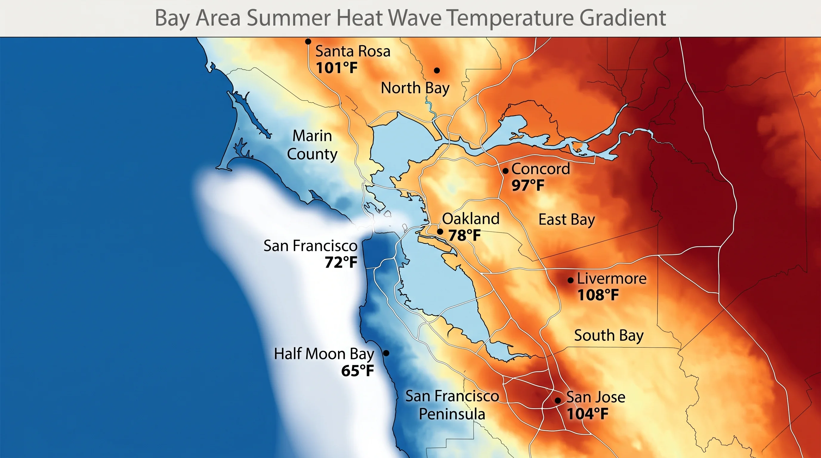
During heat waves, the Bay Area's geography creates extreme temperature disparities that track closely with marine air access. Communities farthest from marine air get hottest. Livermore, isolated east of multiple hill ranges, routinely tops the regional temperature records during heat events. Concord, Walnut Creek, and Santa Rosa in the North Bay also experience intense heat. The South Bay, San Jose and its surrounding communities, routinely approaches or exceeds 100 degrees during major heat events.
The coast and the communities with direct Bay access moderate significantly. San Francisco rarely exceeds 90 degrees even during extreme Bay Area heat events, because enough marine air continues to filter through the Golden Gate to suppress temperatures. Oakland and Berkeley, with direct Bay exposure, stay notably cooler than their inland counterparts. During a heat wave where Livermore hits 108 and San Jose hits 100, Oakland might reach only 82 and San Francisco 75 degrees.
Notable Bay Area Heat Events
The September 2022 Bay Area heat wave set records across the region, with temperatures reaching or exceeding 100 degrees in dozens of inland communities and pushing past 110 degrees in some inland East Bay and South Bay locations. San Jose recorded 109 degrees, its hottest temperature on record. Even San Francisco broke 100 degrees at some weather stations, a number that seemed climatologically impossible before it happened.
The July 2006 heat wave, which affected much of California, was among the most lethal in the state's history. The combination of extreme heat and overnight temperatures that remained dangerously high, preventing the body from recovering overnight, produced hundreds of heat-related deaths across California, concentrated in the same inland communities that see the most extreme temperature spikes. Bay Area heat waves are not merely uncomfortable. They are public health emergencies for vulnerable populations and for anyone without access to cooling.
Overnight Temperatures: The Hidden Danger
The deadliest Bay Area heat events are distinguished not by their daytime highs but by their overnight lows. In a typical heat event, temperatures drop significantly at night as the marine layer recovers. The Bay's cooling influence becomes apparent after dark, and communities along the Bay shore can see overnight lows return to the 60s Fahrenheit even after 100-degree days.
In the worst heat events, the marine layer fails to recover overnight. High pressure remains strong, the air stays dry, and buildings that absorbed heat all day continue radiating it through the night. Overnight lows in some inland communities can stay above 80 degrees Fahrenheit, conditions that make it impossible to cool down by simply opening windows, and that cause serious physiological stress in anyone without mechanical cooling. Checking both the daytime high and the overnight low during heat watches is important for understanding actual risk.
Bay Area heat waves are becoming more frequent and more intense as background temperatures rise. The region's long history of mild summers has left residents and infrastructure poorly adapted to extreme heat, which makes these events more consequential here than in places that have learned to live with summer heat as a routine condition. For anyone planning outdoor activities or travel to inland Bay Area communities from June through October, monitoring heat watches and advisories from the National Weather Service is genuinely important.