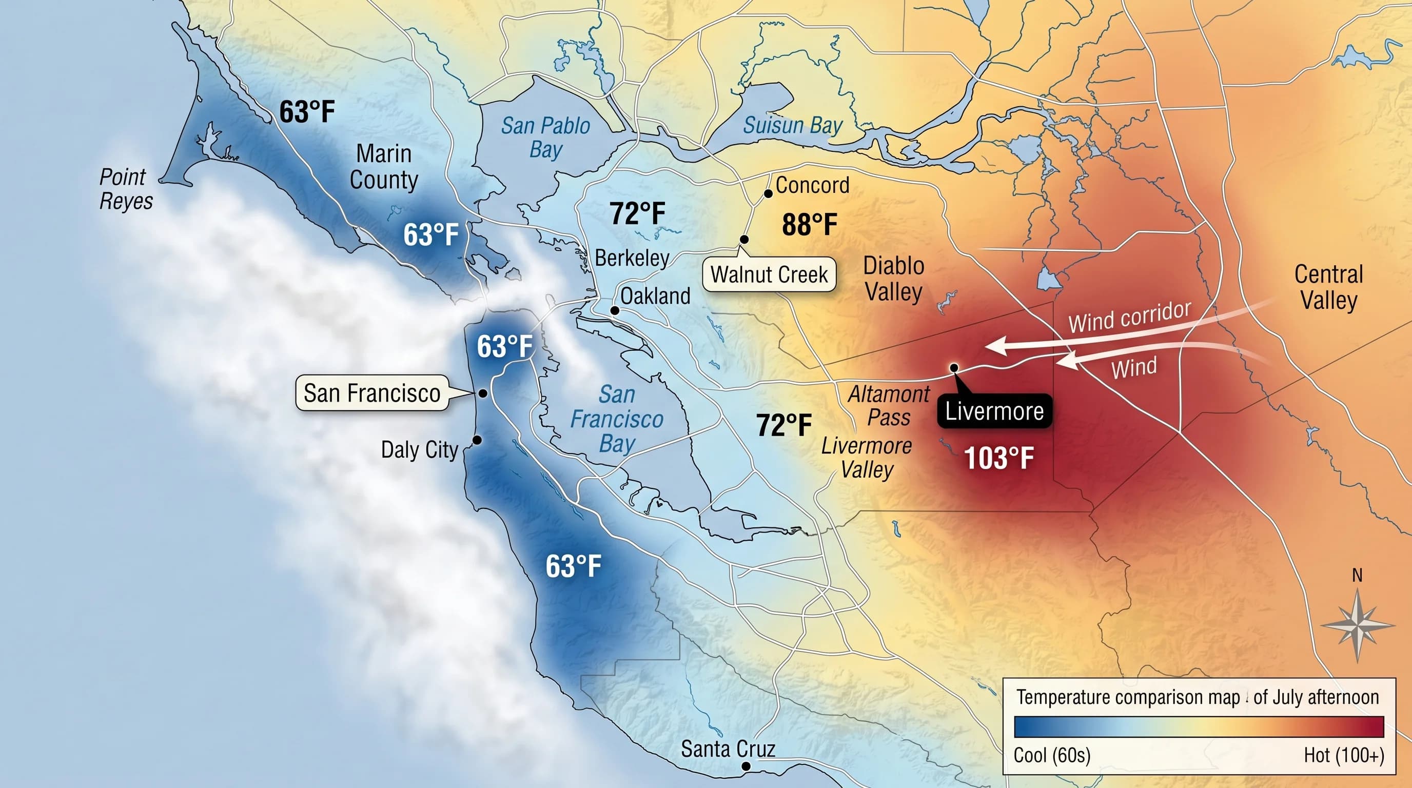
On most Bay Area summer afternoons, Livermore is the hottest place in the region. Not by a small margin, either. While San Francisco hovers at 63 degrees under its marine layer, Livermore is commonly pushing 100. Concord might reach 92, Walnut Creek 88, but Livermore tends to sit a tier above them, in the zone where it feels less like Northern California and more like the Central Valley. This is not an accident of location. It is the result of Livermore Valley's specific geography, which funnels warm air in, traps it there, and prevents the marine layer from doing much of anything to cool it down.
The Geography That Makes Livermore Hot
Livermore sits in the Livermore Valley, a roughly east-west oriented valley bounded by the Diablo Range to the east and the hills of the Mount Diablo foothills to the north. This orientation matters enormously. During summer, the inland valleys of California heat up dramatically during the day, creating low pressure over the Central Valley. This creates a pressure gradient that pulls cool, moist air from the coast inland. That air flows through the corridors in the East Bay hills, the Altamont Pass to the east of Livermore being the most important.
But here is the catch: by the time the marine air makes it through the various passes and over the ridges to reach Livermore, it has warmed considerably through adiabatic compression and mixing with the hot interior air. The same marine flow that cools Oakland to 72 degrees arrives in Livermore having lost much of its cooling effect. On days when the marine push is weak, Livermore essentially sits in stagnant, sun-baked valley air with no relief.
The valley's orientation also means it receives strong afternoon winds funneling through Altamont Pass from the west. These winds are not the cool marine winds people hope for; they are hot, dry, Central Valley air that has been heated over the San Joaquin and arrives in Livermore as hot wind, which accelerates evaporative drying and makes high temperatures feel even more intense. When temperatures in the valley floor reach 100 degrees with strong hot winds, the experience is distinctly uncomfortable.
How Hot Does Livermore Actually Get?
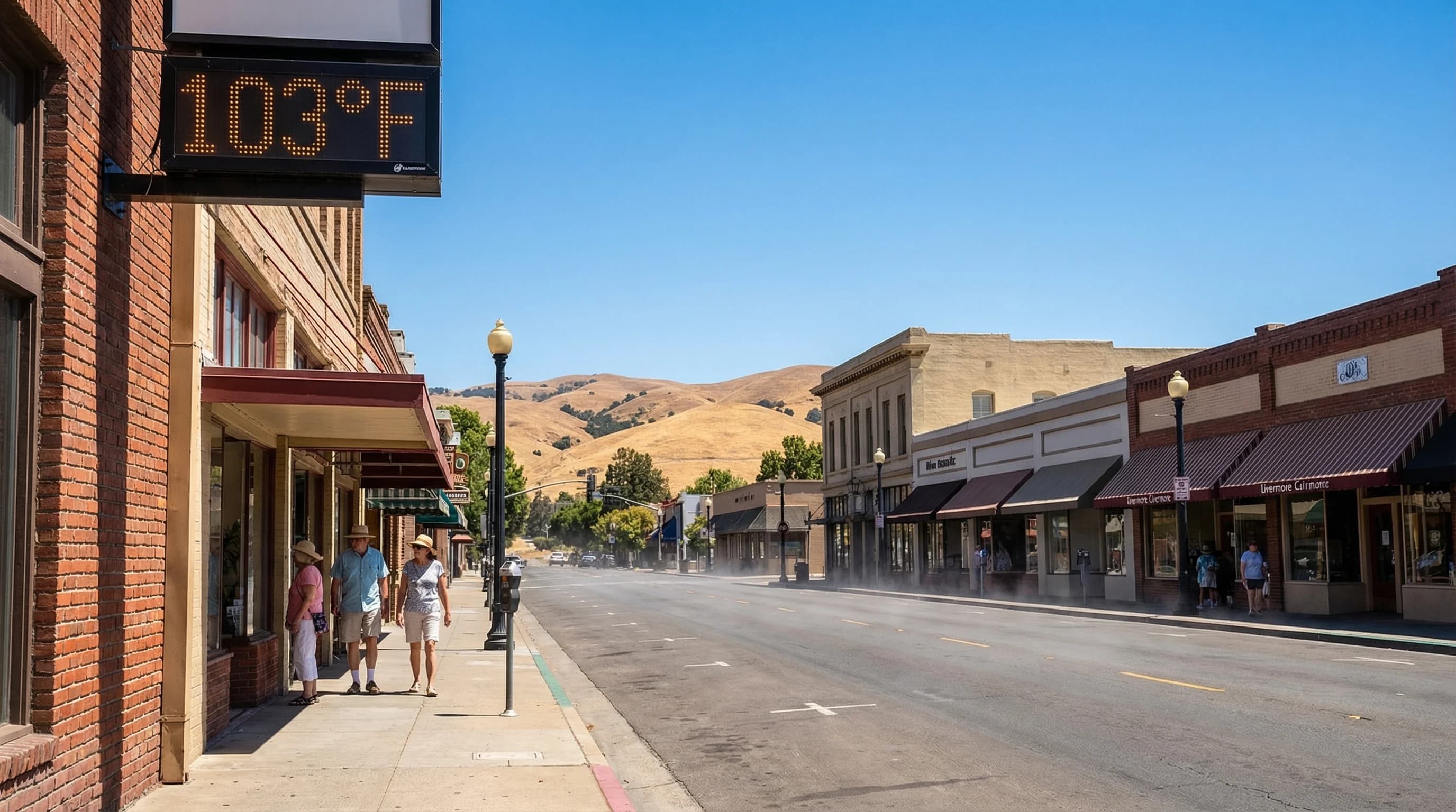
Livermore's average high temperature in July is around 93 degrees Fahrenheit. That number, while significant, understates what actually happens during heat events. On the hottest days of summer, typically during heat waves when high pressure builds over the interior West and blocks the marine flow, Livermore regularly sees temperatures of 105 to 110 degrees Fahrenheit. The all-time record is 115 degrees. These are Central Valley numbers, not Bay Area numbers.
The comparison with coastal communities is stark. On a day when Livermore reaches 107, Half Moon Bay, on the other side of the hills, just 30 miles to the west, may be sitting at 62 degrees in fog. San Francisco, 40 miles away, might be 65. The Bay Area contains, within its boundaries, the full range of California summer experience from coastal cool to desert-adjacent heat, and Livermore sits firmly at the hot end of that spectrum.
Livermore vs. Concord and Walnut Creek
The question of why Livermore runs hotter than its East Bay neighbors like Concord and Walnut Creek comes down to relative exposure to the marine layer. Concord and Walnut Creek sit in the Diablo Valley, west of the Diablo Range and in better position to receive some marine air moving through the Carquinez Strait. The marine flow through Carquinez brings cooler, moister air into the Contra Costa interior, which moderates temperatures in Concord and Walnut Creek relative to Livermore.
Livermore, by contrast, is on the other side of the Mt. Diablo foothills from the Carquinez corridor and must rely primarily on the Altamont Pass flow, which as noted above brings hot Central Valley air more often than cooling marine air. This geographic difference of a few miles and a few hundred feet of hill elevation produces a consistent temperature advantage for Concord over Livermore of five to ten degrees on summer afternoons.
Even within the Livermore Valley, conditions vary. The western parts of Livermore, closer to the Tri-Valley towns of Pleasanton and Dublin, sit slightly more exposed to marine air moving through the low points in the hills and tend to run slightly cooler than the eastern Livermore areas nearest Altamont Pass. The difference is modest, a few degrees at most, but experienced residents notice it.
Livermore in Winter: A Different Story
Livermore's inland location and valley topography make it a cold place in winter, which surprises visitors who know only its summer heat. Cold, dense air drains from the surrounding hills into the valley floor on clear, calm nights and pools there, producing radiative cooling and fog that can be intense. Tule fog, the thick ground-level fog that forms in California's inland valleys during winter, is a regular winter visitor to Livermore. The valley can be fogged in for days at a stretch during winter high pressure events while coastal communities enjoy clear skies.
Frost is common in Livermore from November through March. The same topographic bowl that traps summer heat traps winter cold air, and overnight lows in the upper 20s to low 30s Fahrenheit are not uncommon during cold snaps. Livermore's wine grape growers, the valley is home to a significant wine region, are intimately familiar with frost risk calendars in ways that Napa Valley growers, with their more moderate Bay influence, are not.
Livermore Valley is, in essence, a miniature Central Valley climate enclave within the Bay Area's coastal influence zone. It experiences the full sweep of California's inland climate in a region that most people think of as coastal and mild. If you want to understand just how much geographic variation the Bay Area contains in a small space, drive from Ocean Beach in San Francisco to downtown Livermore on a July afternoon. The weather you encounter at each end of that 40-mile drive will feel like different states.