The Berkeley Hills form one of the sharpest weather boundaries in the Bay Area. On the western side of the ridge, Berkeley's flatlands experience classic Bay Area coastal weather: summer fog, cool temperatures, and the persistent westerly onshore flow. On the eastern side, the story is completely different. The hills block the marine layer from reaching the Lamorinda communities of Lafayette, Moraga, and Orinda, which sit in sheltered inland valleys with summer temperatures that regularly top 90 degrees Fahrenheit. The distance between Berkeley's western flatlands and Orinda is less than eight miles, but the temperature gap on a hot summer afternoon can exceed 25 degrees. The Berkeley Hills are not just a scenic backdrop; they are a genuine weather divide.
Why the Hills Create Such a Sharp Divide
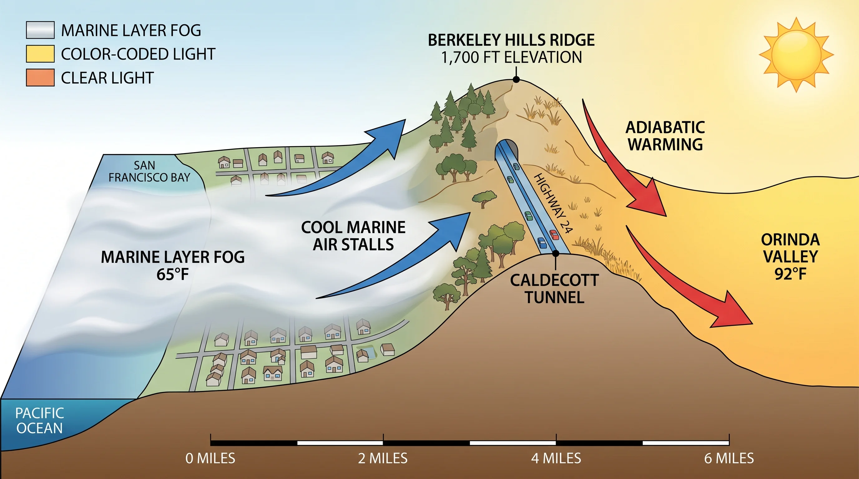
The mechanism is orographic blocking, the same process that creates rain shadows and fog shadows throughout the Bay Area. The dominant summer wind pattern brings cool, moist air from the Pacific across the Bay and into the East Bay flatlands. When this marine layer encounters the Berkeley Hills, which rise to roughly 1,700 feet at their highest points, it stalls. The hills are high enough and continuous enough to prevent most of the marine air from flowing through to the eastern valleys.
The cold air pools on the western side of the ridge, keeping Berkeley and the flatlands cool. On the eastern side, the air that does make it over the ridge descends and warms through adiabatic compression, arriving in Orinda and Lafayette as noticeably warmer than it started. This process, combined with the loss of the marine layer's cooling influence, produces the Lamorinda heat that makes those communities feel like a different region altogether.
In winter, the dynamic partly reverses. Cold air from the Central Valley can drain westward through the passes in the Berkeley Hills during calm, clear nights, bringing freezing temperatures to the inland valleys that are milder just a few miles away in Berkeley. The valleys around Orinda and Moraga see significantly more frost than Berkeley proper.
Berkeley Flatlands vs. the Hills Themselves
Within Berkeley itself, there is a meaningful weather gradient between the flatlands near the Bay and the residential hill neighborhoods closer to the ridge. The Berkeley flatlands, from University Avenue down to the waterfront, sit fully in the marine layer's path and experience the coolest, foggiest conditions the city has to offer. Average summer afternoon temperatures here run in the mid-60s Fahrenheit, with frequent fog and afternoon westerly winds.
The hill neighborhoods, Claremont, the Berkeley Hills, Thousand Oaks, sit at elevations of 400 to 800 feet and occupy a transitional zone. They receive less direct marine push than the flatlands because they are slightly above the densest part of the low marine layer. On clear days they can be warmer than the flatlands and may sit above the fog bank. But on strong marine push days, the fog climbs the western slopes of the hills and these neighborhoods can be completely fogged in while the inland communities remain sunny.
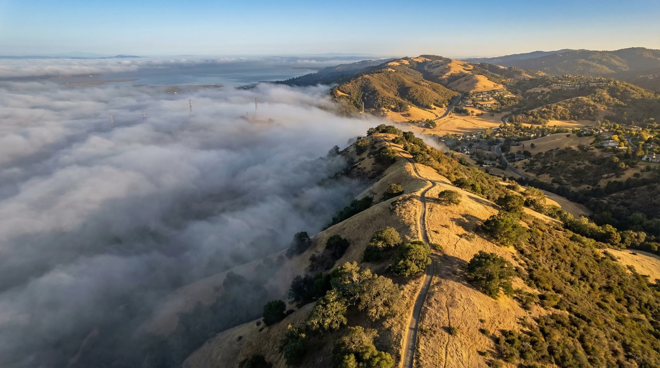
Tilden Regional Park, running along the ridge crest, experiences the most variable weather of any Berkeley area location. The ridge is exposed to wind from both sides, and the fog frequently flows over the crest in visible curtains on summer afternoons, creating a dramatic visual spectacle that also means any hiker crossing the ridge needs a layer they did not need when they started.
Lamorinda: The Hot Side of the Ridge
Lafayette, Moraga, and Orinda, collectively known as Lamorinda, occupy sheltered inland valleys east of the Berkeley Hills. These are genuinely different weather communities from their East Bay flatland neighbors. Summer afternoons in Orinda routinely reach 90 to 95 degrees Fahrenheit, with occasional heat events pushing past 100. The marine layer that keeps Berkeley at 64 degrees makes it only partially into these valleys, and even when it does, it typically burns off quickly on summer mornings.
The Lamorinda valleys also experience significant temperature inversions on clear nights. Cold, dense air settles in the valley floors overnight, and morning temperatures in Moraga in winter can drop into the upper 20s or low 30s, conditions that would be extraordinary in San Francisco just fifteen miles away. The same geography that traps summer heat traps winter cold air.
For Orinda and Lafayette residents, the Berkeley Hills are not an abstract geographic feature; they are a daily weather reality. The simple act of driving over Highway 24 through the Caldecott Tunnel means transitioning between two genuinely different climates. On a hot summer afternoon in Orinda, the western sky often shows a wall of white fog sitting atop the ridge, close enough to feel tantalizing but reliably blocked by the very hills that define the landscape.
Practical Implications: Planning Around the Divide
The Berkeley Hills weather divide has real consequences for daily life on both sides. In summer, residents of the Lamorinda communities make use of the Berkeley Hills as a heat escape: a 20-minute drive over the ridge to Berkeley or the East Bay flatlands means dropping 15 to 20 degrees in temperature. Conversely, flatland residents who want to hike in Tilden Regional Park in July need to pack for both warm starting conditions and cold, foggy summit weather.
The Caldecott Tunnel on Highway 24 has become an informal weather benchmark for commuters: "it was sunny in Orinda and completely foggy coming out of the tunnel in Oakland" is a common observation that captures the divide in a sentence. That same commute works in reverse as well, Oakland workers heading home to Lamorinda drive from gray and 65 to golden and 88 on the same afternoon.
For outdoor events, the hills create planning challenges. An outdoor event at Tilden park in July can range from comfortable fog to hot and sunny depending on exactly where along the ridge the event is located and how strong the marine push is on that particular day. The weather divide is reliable in its overall pattern but variable in its exact daily position, which is what makes the Bay Area's microclimate geography both fascinating and genuinely difficult to predict with precision.