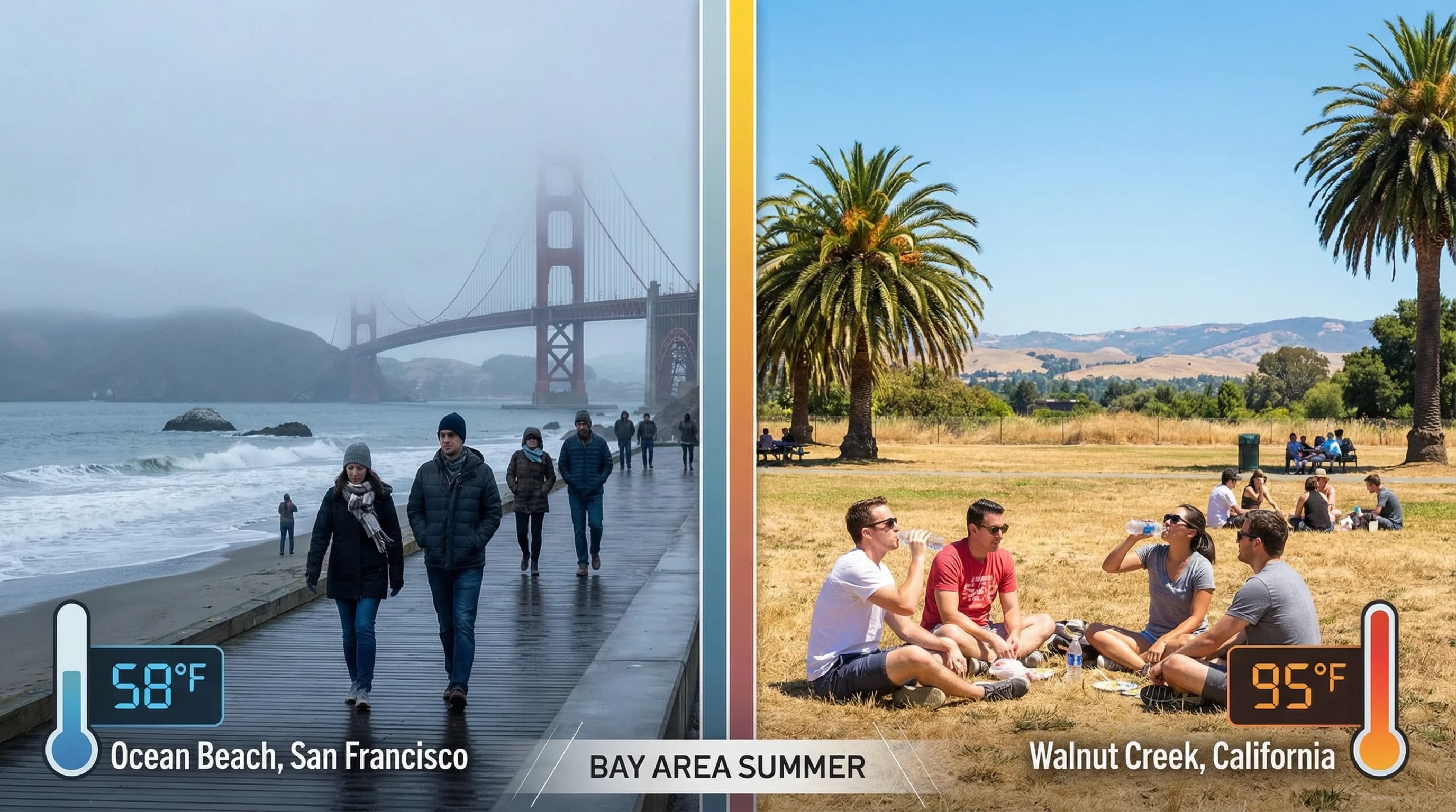
Spend a summer in the Bay Area and you encounter something that stops making sense if you think about it too hard. On the same Tuesday afternoon in July, San Francisco is 65 degrees and gray. Livermore, 30 miles away, is 97 degrees and blazing. Half Moon Bay sits at 62 degrees with a sea breeze that makes you reach for a jacket. Walnut Creek is 92 degrees. These are not different regions in different states. They share the same metro area, the same traffic reports, the same local news. They just have fundamentally different climates, stacked against each other in one of the most geographically compressed temperature contrasts found anywhere on Earth.
How Big Is the Temperature Gap Between Coast and Inland?
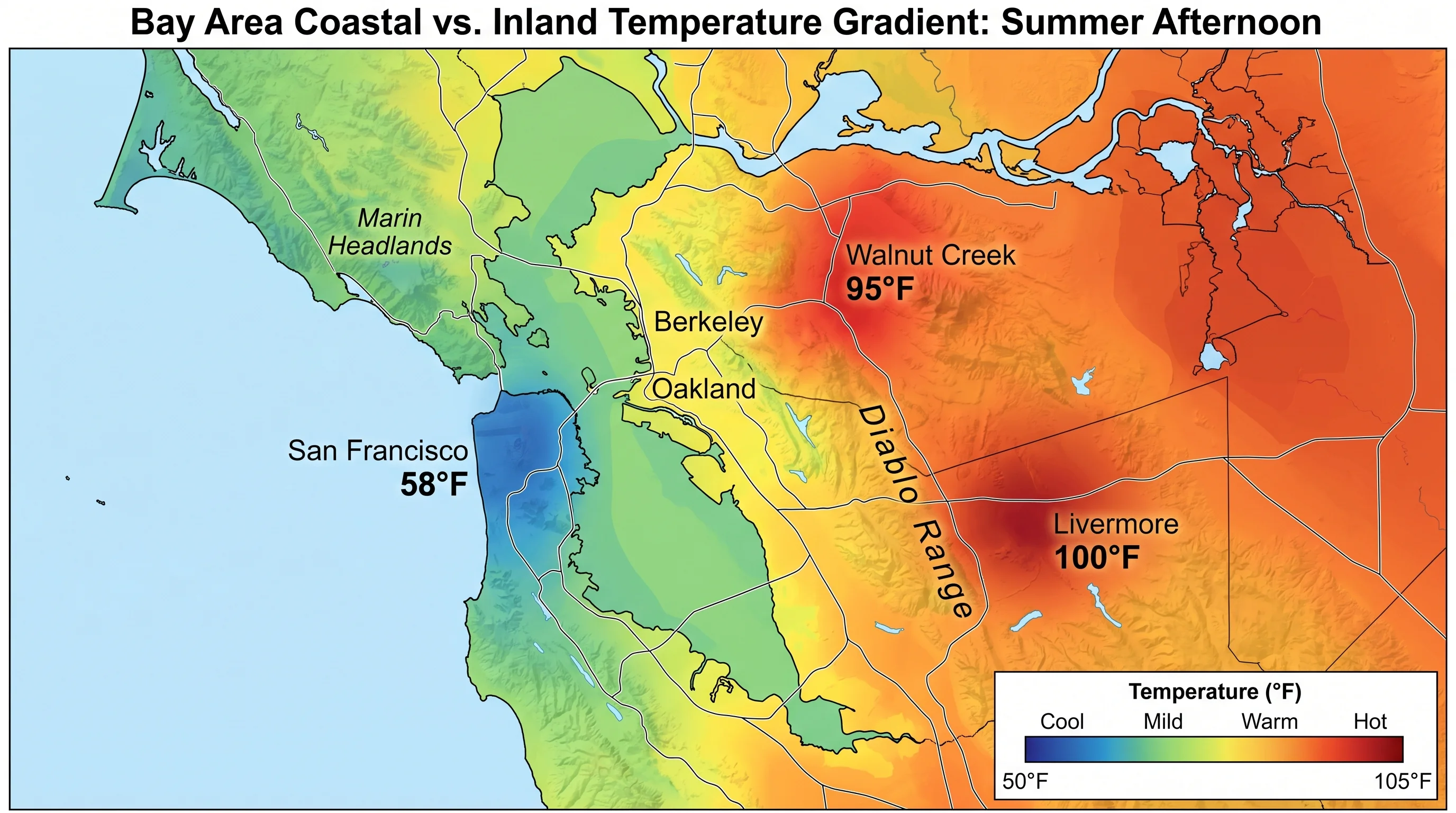
On a typical Bay Area summer day, the gap between the coast and inland valleys runs 15 to 25 degrees. On strong heat days, it pushes to 30. The numbers are consistent enough to qualify as climatological baselines rather than weather events. San Francisco averages summer highs around 65 to 67 degrees. Walnut Creek averages summer highs around 88 to 92 degrees. Livermore, deeper in the inland valley and shielded by terrain from any residual coastal influence, runs 92 to 96 degrees as its normal summer range, and frequently crosses 100 degrees during heat events when the coast is still at 68.
These numbers matter because they define what visiting the Bay Area actually means. A tourist who packs for the coast and then drives inland for the day needs a completely different wardrobe. A Bay Area resident who commutes from San Francisco to Walnut Creek experiences a climate shift every workday. The temperature gradient is not a curiosity or a seasonal anomaly. It is a permanent feature of life in this region, driven by forces that do not change from year to year.
Why the Pacific Ocean Keeps the Bay Area Coast Cold Year-Round
The California coastline runs along the eastern edge of the Pacific, and the ocean water here is cold by the standards of any populated coastline in America. The reason is a combination of two oceanographic forces. The California Current flows southward from the Gulf of Alaska, carrying cold subarctic water along the coast. This alone would make the water cooler than the Atlantic at comparable latitudes. But the Bay Area also sits in an upwelling zone, where seasonal winds push surface water offshore, pulling cold deep water up to replace it.
The result is a Pacific Ocean surface temperature off the Bay Area coast that runs 55 to 58 degrees Fahrenheit year-round. Not 55 in winter and 70 in summer. Year-round. This cold water is in constant contact with the air above it, cooling it continuously. When that chilled marine air moves onshore toward San Francisco or Half Moon Bay, it arrives already cold. The coast never gets a chance to heat up the way inland areas do because the ocean is right there, constantly replacing any warmth that builds up with a fresh supply of cold air off 57-degree water. The ocean is not a passive backdrop. It is an active temperature control system operating every day.
How Inland Valleys Reach 95°F While SF Stays at 65°F
Inland valleys like the Livermore Valley and the area around Walnut Creek and Concord heat up for the opposite reason: they receive no ocean cooling. Direct sunlight hits valley floors for 12 to 14 hours in summer. The surrounding terrain, hills and ridgelines on most sides, blocks airflow and traps the heat that builds throughout the day. Without the cold ocean nearby to moderate temperature, the only limit on how hot these valleys get is the intensity of the sun and the duration of daylight.
The soil and rock in these inland valleys also contribute. Dark, dry soil absorbs solar radiation all day and re-radiates it as heat. The grassy, sun-baked hillsides that ring communities like Livermore and Antioch are themselves radiating heat back into the air, amplifying the surface temperature beyond what direct sun alone would produce. When the Central Valley, just a mountain range away, heats to 100 to 105 degrees in summer, the Tri-Valley sits in its immediate thermal neighborhood and behaves accordingly. These are hot valleys by any standard, and the fact that they sit within 30 miles of a 65-degree coast makes them feel even more extreme by contrast.
The Pressure System That Locks the Temperature Divide in Place
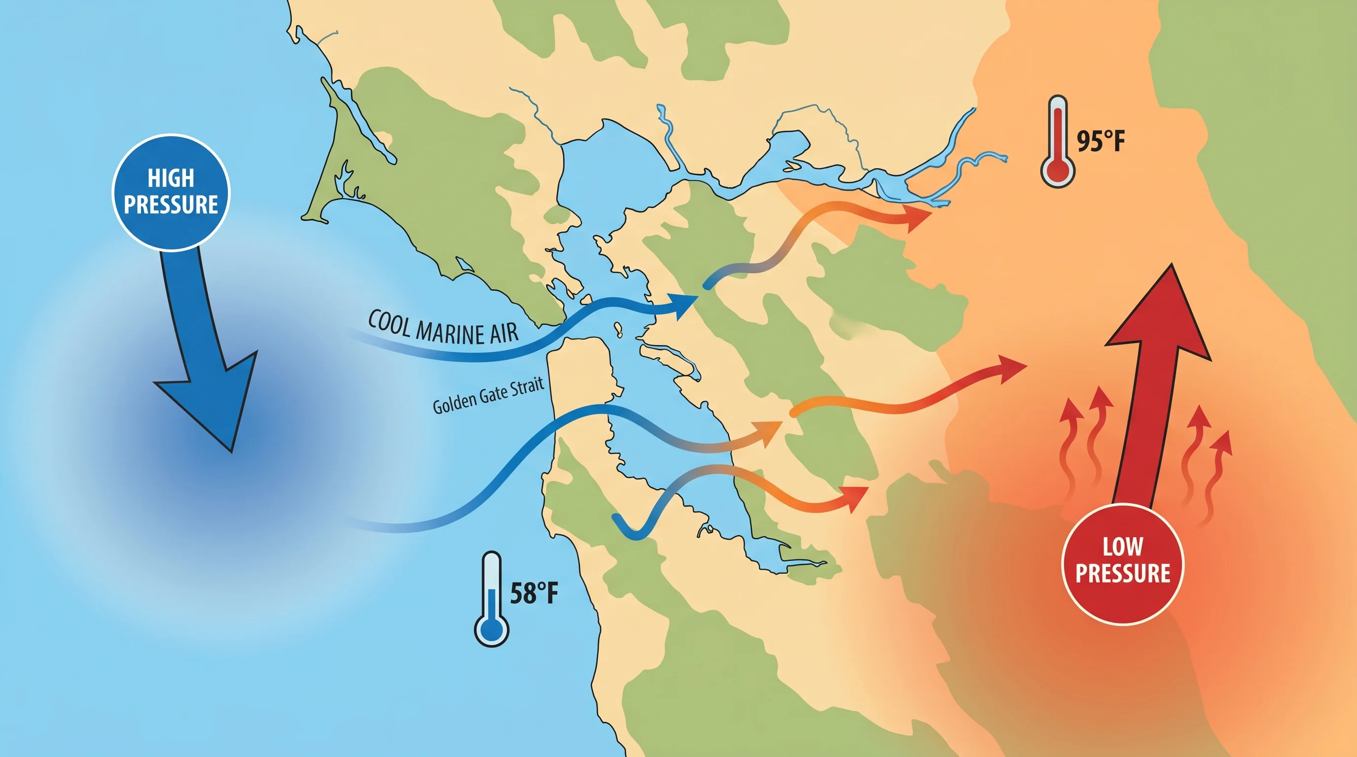
Here is the part that surprises people: the temperature difference between the coast and inland is self-reinforcing. It does not just exist; it actively perpetuates itself through a pressure system that operates every summer day. When inland valleys heat up, the air over them warms, expands, and rises, creating a zone of low atmospheric pressure. Cold, dense ocean air, sitting at higher pressure offshore, flows toward that low-pressure zone. This is the same pressure gradient that drives any wind system, and in the Bay Area it means that the hotter the inland valleys get, the more strongly they pull cold ocean air toward the coast.
This is why the coast cannot heat up even when the rest of the region bakes. The inland heat is actively pulling cold air off the ocean and depositing it along the coast and through the Golden Gate. The more extreme the inland heat, the stronger the marine push. On a 105-degree day in Antioch, wind through the Golden Gate can hit 30 to 40 miles per hour, and San Francisco sits at 62 degrees regardless of how hot everything to the east is running. The pressure system locks both extremes in place simultaneously, which is why you can have a record heat wave inland while San Francisco reports nothing unusual for a summer day.
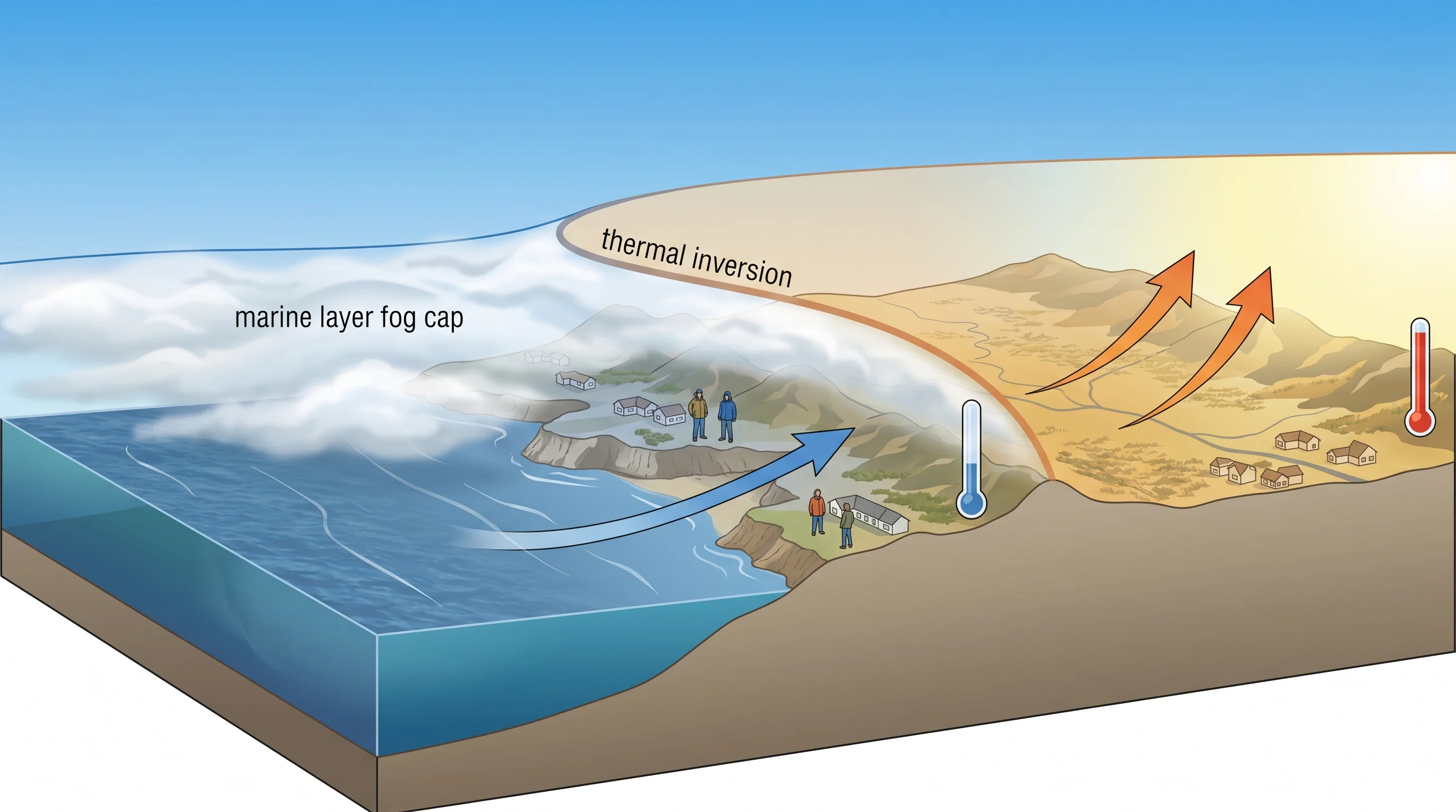
The Marine Layer as an Additional Cooling Force
Beyond the simple physics of cold ocean water, the marine layer adds a second cooling mechanism that is specific to summer. The marine layer is a blanket of cool, moist air that sits close to the ocean surface and pushes inland over the coast. When it is thick enough, it becomes fog visible from the ground. When it is thin, it manifests as a high gray overcast that blocks direct sun without producing visible ground fog. Either way, it keeps coastal temperatures lower than they would be under clear skies.
The marine layer is most persistent in June, July, and August, exactly the months when California sees its strongest upwelling and therefore its coldest ocean water. The fog that Karl the Fog fans celebrate is not just atmospheric theater; it is a physical barrier between the coast and any warmth that might otherwise build. On a clear day, the coast can briefly warm to 70 or 72 degrees. Under marine layer overcast, it stays at 62 to 65. That difference is meaningful for anyone spending the day outside. And the inland areas, beyond the reach of the marine layer, see clear sky from morning to evening and heat up without interruption.
Using the Temperature Gradient to Pick the Right Destination
Once you internalize the coast-to-inland temperature gradient, Bay Area weather becomes predictable rather than mysterious. The pattern holds on almost every summer day, making it genuinely useful for planning. If you want warmth and sun, go inland. The guarantee holds from May through October. Heading to Walnut Creek, Livermore, or anywhere in the Tri-Valley in July puts you in 85 to 95 degrees with clear skies. No guessing required.
If you want cool relief during a heat event, the coast is reliable in the opposite direction. San Francisco and Half Moon Bay never get truly hot in summer. The coldest, grayest, most reliably cool stretch of summer in the Bay Area is the coast, and it is reliable because the physics driving it are strong and consistent. The gradient is not something that might happen. It is something that does happen, every summer day, driven by cold ocean water and hot inland valleys that have been locked in their respective temperature ranges since long before anyone built a city here.