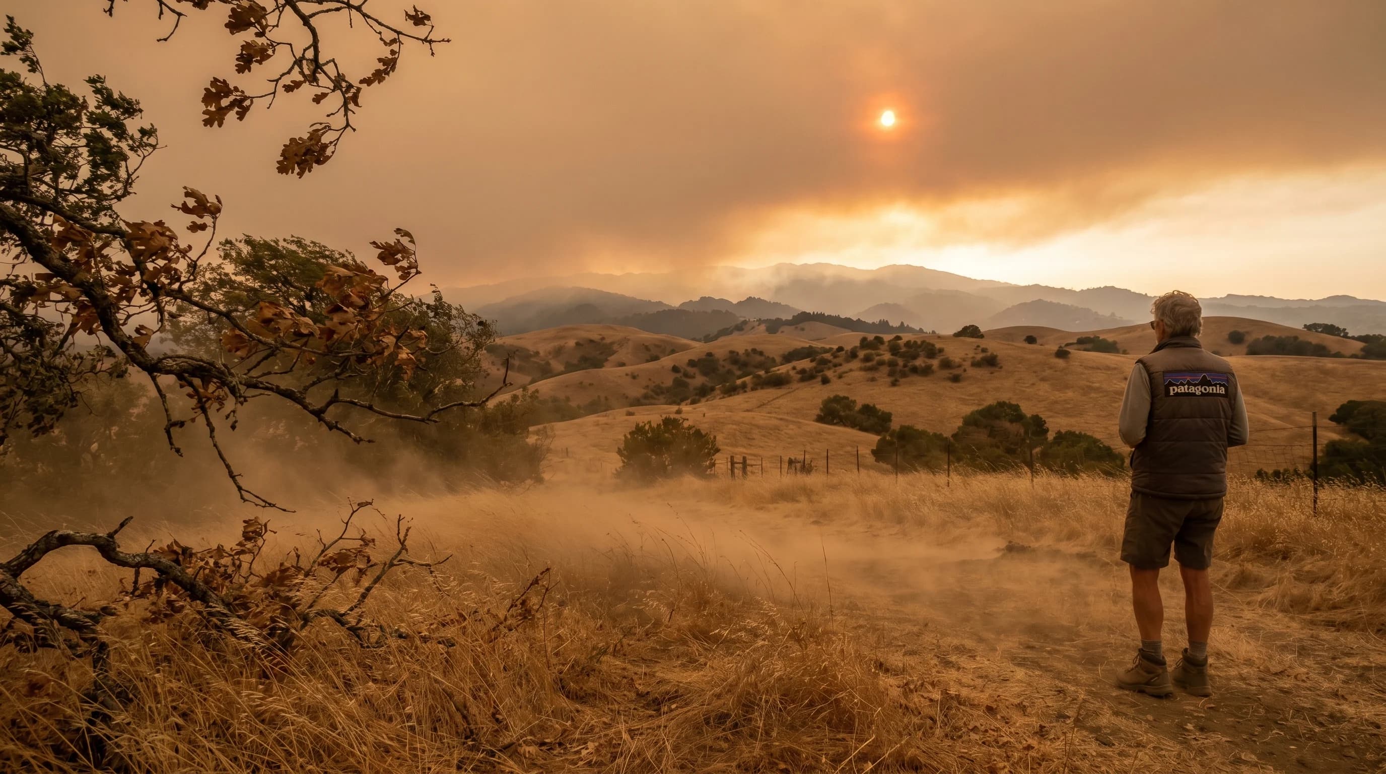
On the evening of October 8, 2017, winds gusting to 79 mph tore through the hills north of San Francisco. By morning, the Tubbs Fire had consumed most of the Coffey Park neighborhood in Santa Rosa, the Atlas Fire was raging in the hills east of Napa, and the Wine Country firestorm had killed 44 people and destroyed nearly 9,000 structures. The fires spread so fast that residents woke to flames at their windows with minutes to evacuate. What made that night so catastrophic was not one unusual thing. It was the Diablo Winds doing exactly what they always do in October, just doing it at full intensity.
Diablo Winds are the most dangerous recurring weather event in the Bay Area. They are not rare freak occurrences. They happen every fall, and every fall they create conditions in which a single spark can become a regional catastrophe. What they are and when they happen is not optional knowledge for anyone who lives east of the Coast Range.
What Are Diablo Winds?
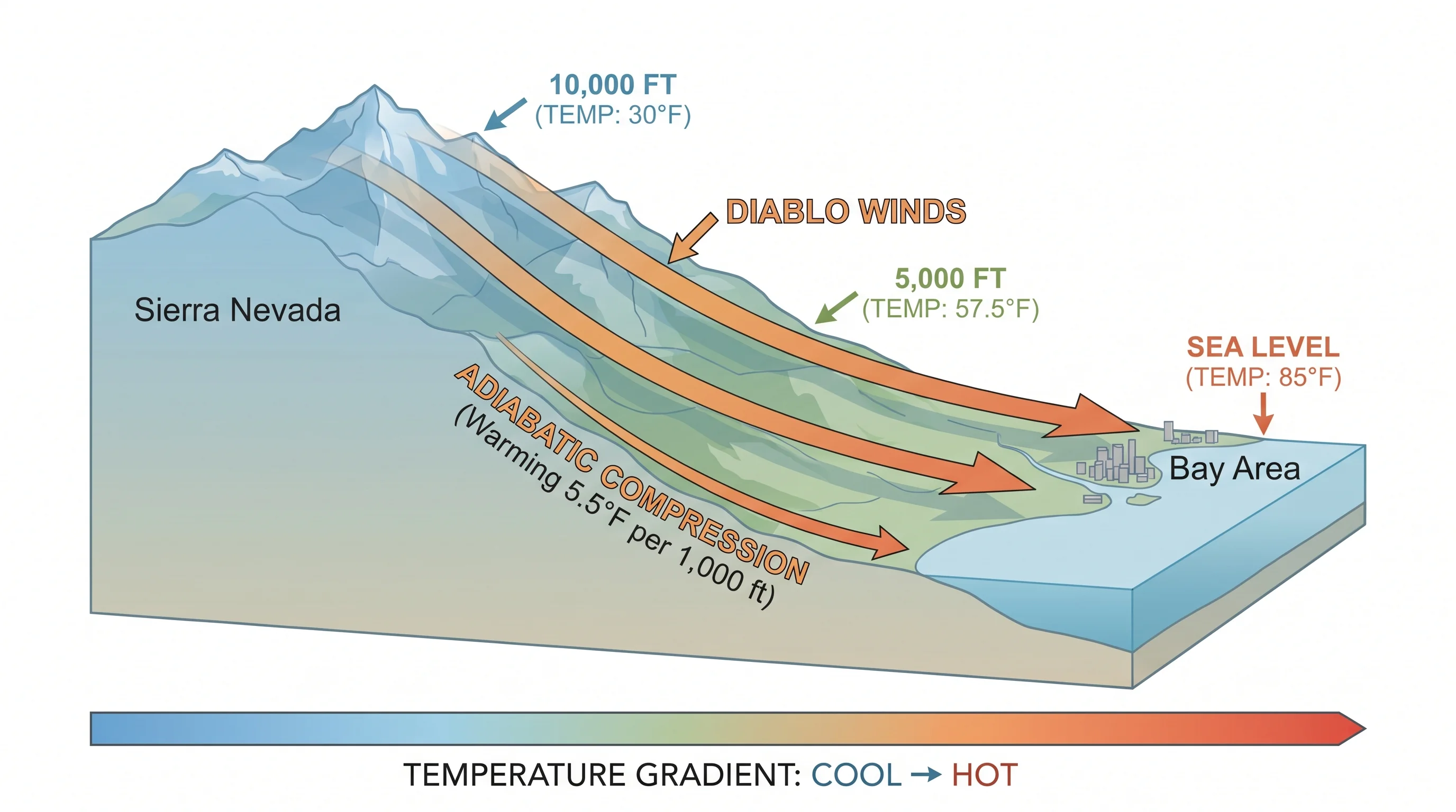
Diablo Winds are hot, dry, downslope winds that descend from the elevated interior of California toward the Bay Area coast. They originate when strong high-pressure systems build over the Great Basin and Sierra Nevada, creating a pressure difference between the inland plateau and the lower coastal zone. Air flows from high pressure toward low pressure, which in this case means it flows west and downhill from the mountains and valleys of the interior toward the Bay and coast. As the air descends from elevations above 5,000 to 8,000 feet down to sea level, it compresses and heats up. It also dries out.
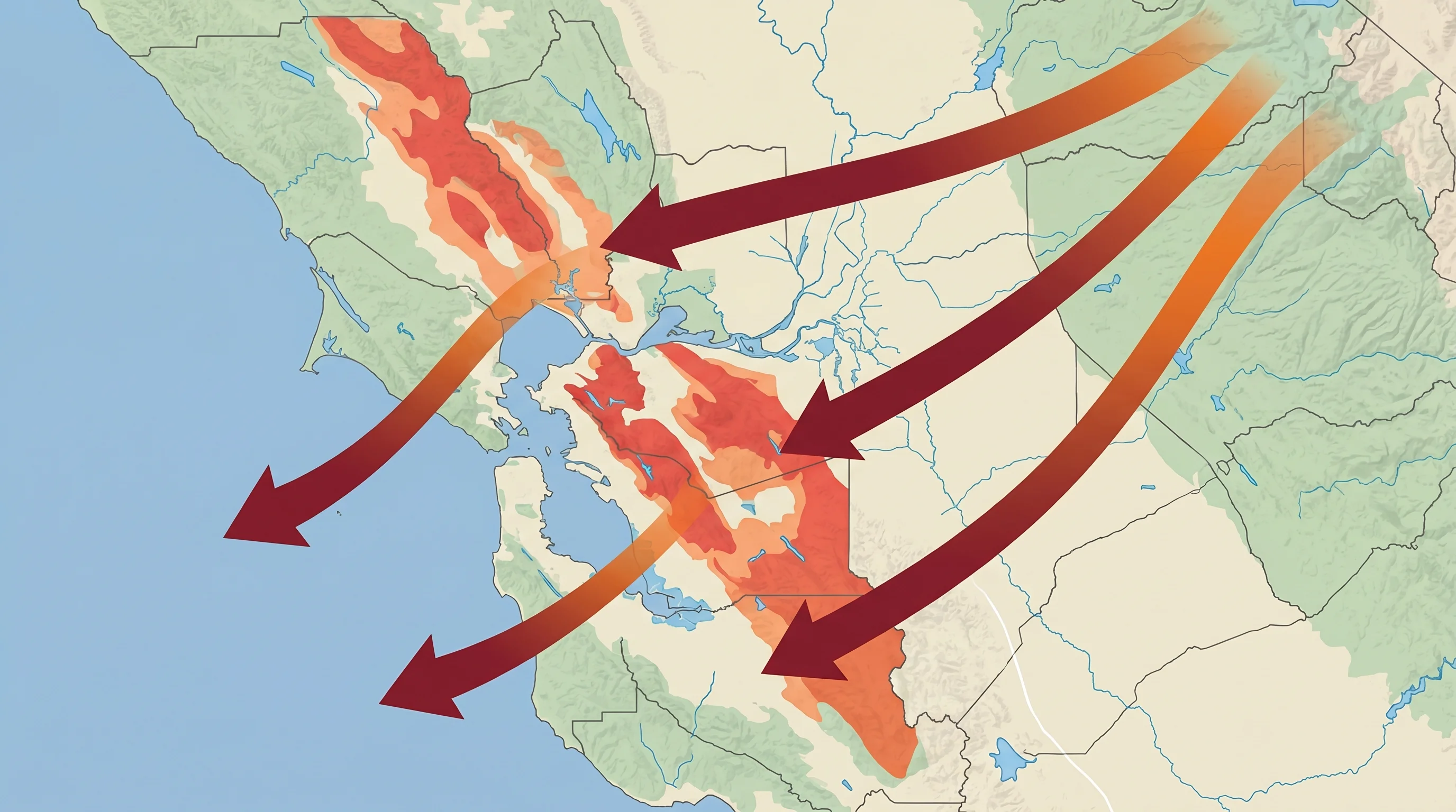
The name comes from Mount Diablo, the prominent peak in Contra Costa County that sits at the geographic heart of the region these winds affect. Unlike the Santa Ana Winds of Southern California, which are better known nationally, Diablo Winds are specific to the Northern California coast ranges and the Bay Area. Both are offshore downslope winds driven by similar physics, but Diablo events tend to be shorter in duration and more localized to the North Bay and East Bay hills. The winds are most intense through mountain passes and canyons that funnel and accelerate airflow, including Altamont Pass, the Carquinez Strait corridor, and the ridgelines of the Diablo Range itself.
When Do Diablo Winds Occur?
Peak Diablo wind season runs from September through November, with October and early November being the most dangerous window. This timing is not a coincidence. It is the worst possible combination of meteorological and ecological factors. By October, California has gone five to seven months without meaningful rain. Grasses and shrubs are fully cured, desiccated to the point where they ignite from a single ember. The coastal forests have drawn down their moisture reserves. Fuel moisture content across the hillsides is at annual minimums.
At the same time, the fall transition brings the first strong high-pressure systems of the season as the Pacific storm track begins to reorganize after summer. These high-pressure cells sit over Nevada and the Great Basin, building the inland-to-coast pressure gradient that drives Diablo events. The combination of extreme fuel dryness and extreme wind creates fire weather conditions that have no equivalent at any other time of year. Diablo events can also occur sporadically in late spring, but spring vegetation is still green and fire risk is substantially lower.
The Physics: Why These Winds Are So Hot and Dry
The extreme temperatures and low humidity of Diablo Wind events are not simply the result of the air coming from a hot place. The physics is more interesting than that. When air descends from high elevation to low elevation, it is compressed by the increasing atmospheric pressure at lower altitudes. Compressed air heats up. This process, called adiabatic compression, warms descending air at a rate of approximately 5.5 degrees Fahrenheit per 1,000 feet of elevation loss. Air descending from 7,000 feet to sea level gains nearly 40 degrees Fahrenheit in temperature through compression alone, before any regional heat source is added.
The drying is equally dramatic. Relative humidity is highly sensitive to temperature. Warm air can hold far more water vapor than cold air, so even if the absolute moisture content of the air stays the same, the relative humidity drops as the air heats up. Air that was at 40 percent relative humidity at 7,000 feet might arrive at sea level at 5 to 8 percent relative humidity simply because it has been compressed and heated so dramatically. This is why Diablo Wind events bring single-digit humidity readings. The air has not lost moisture; it has been heated to the point where whatever moisture it contains is a tiny fraction of what the warmed air can hold. The result is air that is extraordinarily desiccating: it pulls moisture out of vegetation, out of soils, and out of human skin within hours.
How Diablo Winds Fuel Wildfires
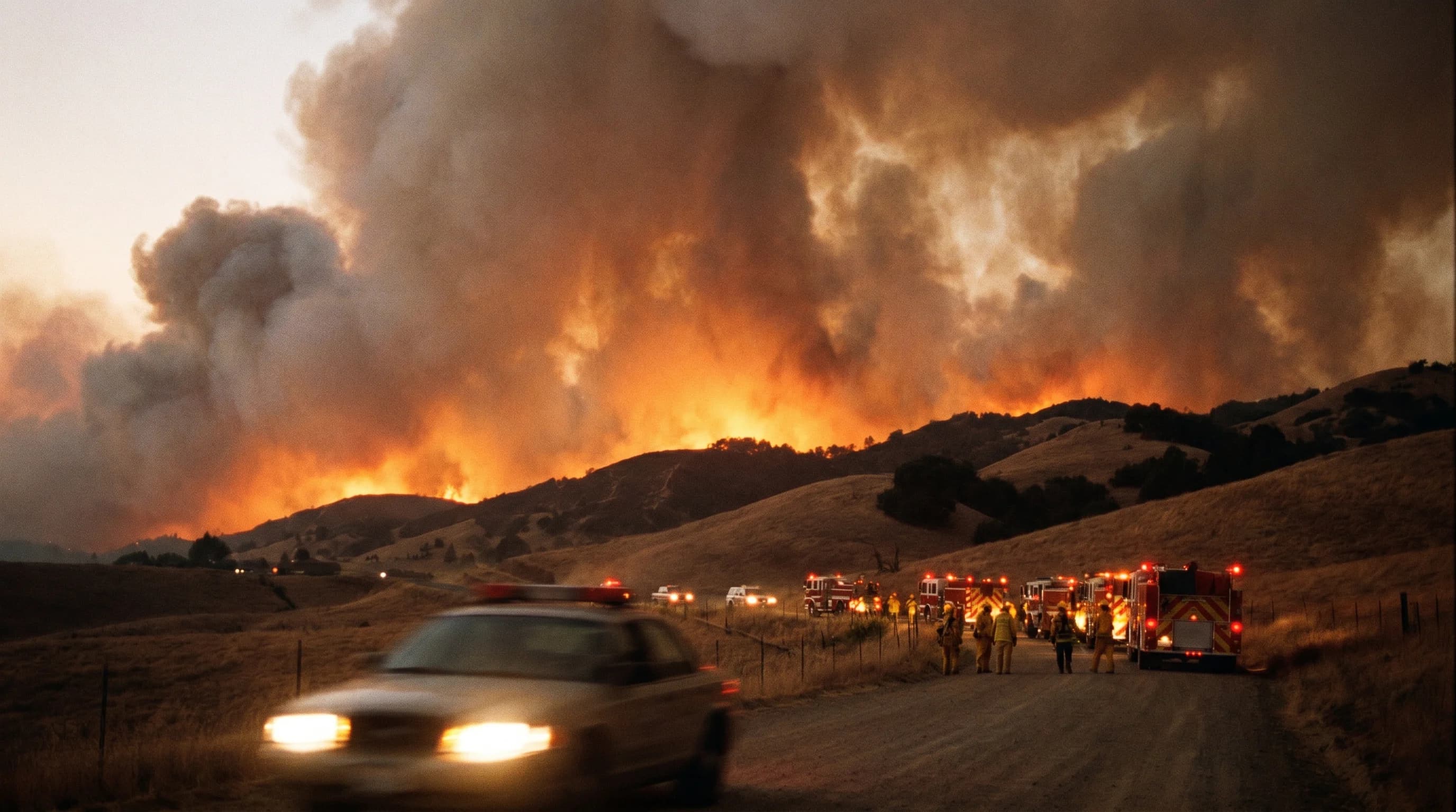
Wildfire behavior under Diablo Wind conditions is qualitatively different from fire behavior under normal conditions. Three factors interact to create something close to worst-case scenario. First, the heat and dryness stress vegetation to the breaking point: humidity below 10 percent effectively removes residual moisture from fuels that were already at annual lows. Second, winds gusting to 50 or 60 mph carry embers far ahead of the fire front, starting new ignitions a quarter-mile or more ahead of the main blaze. A fire that would normally move at walking pace under calm conditions can move at running pace under Diablo winds. Third, those same winds actively suppress firefighting. Aircraft are often grounded when gusts exceed certain thresholds. Ground crews cannot approach from the windward side. Retardant drops are less effective when wind scatters the material before it lands.
Fire behavior scientists describe the combination of fuel moisture below 10 percent, wind gusts above 35 mph, and humidity below 15 percent as the fire weather trifecta. Diablo Wind events regularly hit all three simultaneously. Under these conditions, fires can double in size every few hours. The 2017 Tubbs Fire spread 12 miles in its first three hours after ignition. That pace is incompatible with orderly evacuation if residents are not already prepared to move.
Famous Bay Area Fires Driven by Diablo Winds
The history of Bay Area wildfires is largely a history of Diablo Wind events. The 1991 Oakland Hills Firestorm killed 25 people and destroyed 3,354 homes and apartments in the hills above Oakland and Berkeley. The fire started on a day with low relative humidity and northeast winds gusting to 65 mph, and it spread so fast that residents on foot could not outrun it. Neighborhoods were engulfed in the time it takes to pack a car. The Oakland Hills fire remains one of the deadliest urban wildfires in California history.
The October 2017 Wine Country fires represent the most destructive Diablo Wind event on record. The Tubbs, Atlas, and Nuns fires ignited within hours of each other on the night of October 8 as Diablo winds hit 65 to 79 mph at ridge stations. The Tubbs Fire became the most destructive wildfire in California history at the time, destroying over 5,600 structures in Sonoma County before eventually being surpassed by fires in subsequent years. The 2020 Glass Fire, also driven by Diablo Winds in October, burned through communities in Napa and Sonoma counties that had barely recovered from 2017. The pattern is consistent: October, Diablo Winds, catastrophic loss.
What connects all of these events is not unusual ignition sources. Most started from ordinary causes: power lines, downed equipment, or in some cases causes that were never definitively established. What made them catastrophic was the conditions on the ground and in the air when the spark landed.
How to Stay Safe During Diablo Wind Events
The National Weather Service issues Red Flag Warnings when Diablo Wind conditions are expected: low relative humidity (below 15 percent), strong winds (gusts above 25 to 35 mph), and critically dry fuels. These warnings are not advisory. They are the signal that conditions are in place for fire to spread uncontrollably. During a Red Flag Warning in September, October, or November, the correct response is to treat it as a genuine emergency pre-condition and prepare to move.
Preparation means having a go-bag ready before fire seasonstarts, not after a warning is issued. It means knowing two evacuation routes from your home, because fires can close one before you reach it. It means charging your phone and having a portable charger ready, because power is often cut proactively during Diablo Wind events to reduce ignition risk from downed lines. It means registering for your county's emergency alert system so you receive evacuation warnings directly rather than relying on news coverage. And it means the hardest discipline of all: leaving when the order comes, without waiting for visual confirmation. The 2017 fires spread faster than most people's mental models allowed for. Residents who left immediately survived. Some who waited to see how bad it was did not.
Diablo Winds are a permanent feature of the Bay Area's climate. They are not going away, and if anything, the fire seasons they drive are intensifying as hotter summers leave fuels drier at the start of each fall wind season. The Bay Area is one of the most desirable places to live on the planet, with extraordinary weather for most of the year, but that bargain includes six to eight weeks each fall when the weather becomes genuinely dangerous. Knowing what those weeks look like, and being ready before they arrive, is what separates people who escape safely from people who don't.