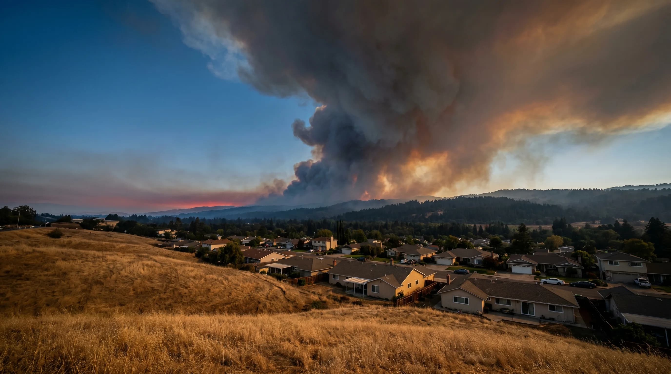
The Bay Area has a fire season, and it has grown more dangerous with each passing decade. What was historically a late-summer risk confined largely to the wildland-urban interface has become a year-round concern, with the most catastrophic events occurring in October and November during offshore wind events. The same geography that makes the Bay Area one of the most climatically diverse regions in North America also makes it one of the most vulnerable to large, fast-moving fires: steep terrain, drought-stressed vegetation, and periodic extreme wind conditions that can turn any ignition into a regional emergency.
The Fuel and Dryness Cycle
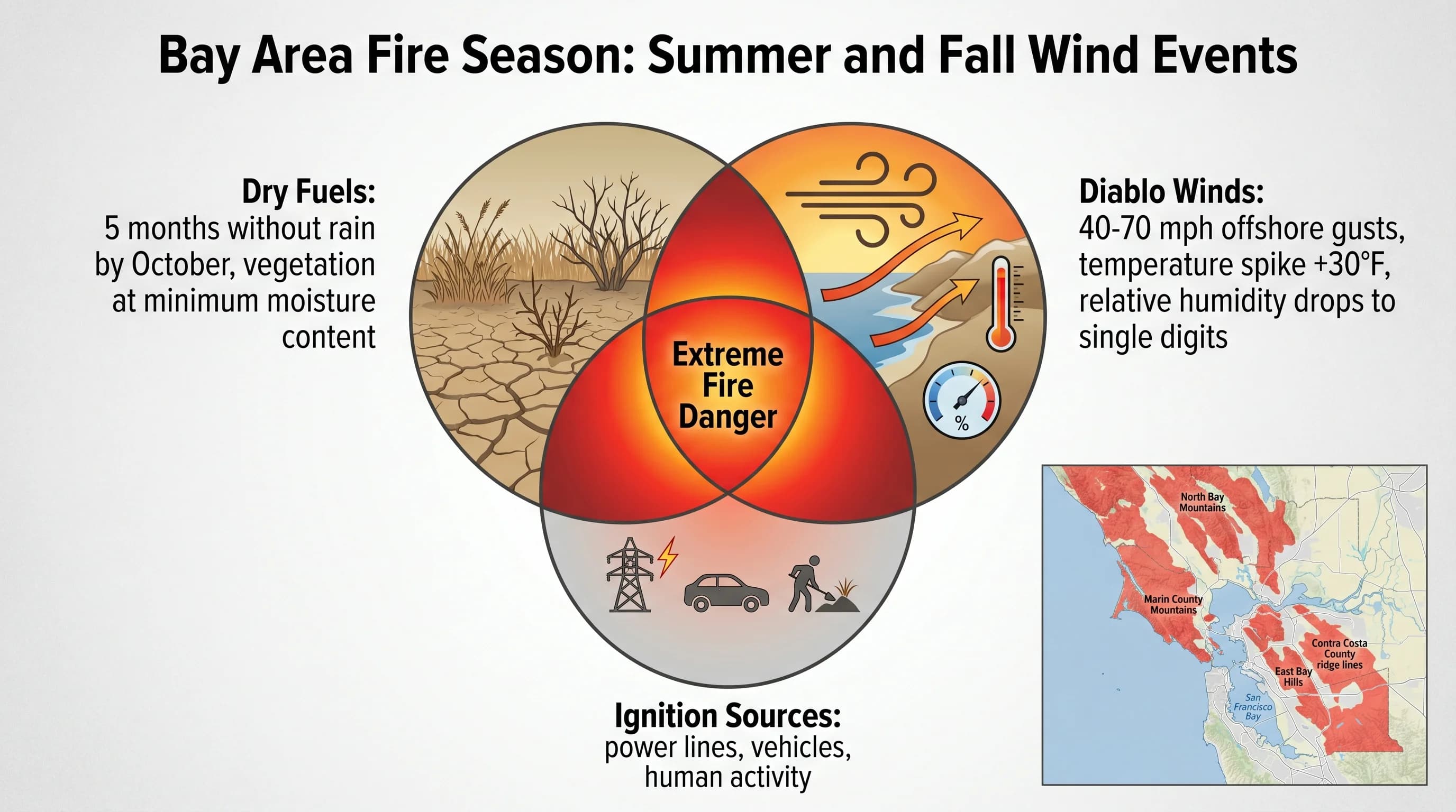
Bay Area fire danger accumulates through the summer and peaks in fall. The region's Mediterranean climate means that essentially no rain falls from May through October. By late September, the grasses and brush that greened up with winter rains and grew actively through spring have been drying for five consecutive months. Fine fuels, the grasses, forbs, and small shrubs that ignite most easily and carry fire fastest, reach their minimum moisture content in September and October. They are, by that point, essentially cured and ready to burn.
The native California vegetation that dominates the Bay Area's wildlands has evolved alongside fire over millions of years. Chaparral, the dominant shrubland of the inner Coast Ranges, is specifically adapted to periodic burning; many species require fire to germinate seeds. Native oak woodlands tolerate low to moderate fire. But fire suppression over the past century has allowed fuel accumulations that are not natural, and the combination of those accumulated fuels with climate change-driven drought and warming means that fires today can be more intense than historical fires that shaped the vegetation communities.
Diablo Winds: The Fire Weather Trigger
The Diablo wind is the specific weather pattern that turns the Bay Area's dry fall conditions into acute fire emergencies. These offshore wind events occur when high pressure builds over the Great Basin or the interior West and pressure drops along the California coast. Air flows from the high pressure toward the low pressure, descending from the Sierra Nevada and interior mountains, compressing and warming as it drops in elevation through the passes and canyons of the Coast Ranges.
The result is wind gusts of 40 to 70 miles per hour in the East Bay hills and North Bay mountains, temperatures that spike 20 to 30 degrees above normal, and relative humidity that can drop to single digits. Any spark, a downed power line, a vehicle spark, a discarded cigarette, ignites quickly in these conditions, and fire spreads at rates that can outpace human ability to evacuate. Wind-driven fires in chaparral and dry grass can move at speeds exceeding a mile per minute in extreme conditions.
Most Dangerous Areas and Recent History
The Bay Area communities at highest risk sit at the wildland-urban interface in the hills that fringe the region. The East Bay hills (Oakland, Berkeley, Moraga, Orinda, Danville, and the surrounding communities) are consistently identified as high-risk, partly because of their terrain and fuel conditions and partly because their proximity to the Bay and its electrical infrastructure creates multiple ignition risk points during wind events. The 1991 Oakland-Berkeley Hills Fire killed 25 people and destroyed nearly 3,500 structures, the most destructive urban wildfire in California history at that time.
The North Bay wine country communities of Sonoma and Napa counties have experienced the most catastrophic recent fires. The Tubbs Fire in 2017 destroyed over 5,600 structures in Santa Rosa, the region's largest city, in a matter of hours during a Diablo wind event. The Kincade Fire in 2019 forced the largest evacuation in Sonoma County history. The LNU Lightning Complex fires of 2020 burned across parts of four North Bay counties. These fires share a pattern: they all started during offshore wind events in fall, all spread extremely rapidly, and all demonstrated how little time residents have to evacuate when fire weather conditions are at their worst.
Fire Weather Season and Preparedness
The National Weather Service issues Red Flag Warnings when conditions are ripe for rapid fire spread: typically when relative humidity drops below 15 percent, wind gusts exceed 25 miles per hour, and vegetation moisture is critically low. Public Safety Power Shutoffs (PSPS), where utilities proactively cut power to prevent powerline-caused ignitions during Red Flag conditions, have become a regular fall occurrence for East Bay and North Bay hill communities.
For residents and visitors in fire-prone areas, fire season preparedness means having a go bag ready by September, knowing evacuation routes from your neighborhood, signing up for local emergency alerts, and following evacuation orders without hesitation. The 2017 and 2019 fires produced both stories of heroic evacuation compliance and tragic cases where delayed departures led to deaths. Fire weather in the Bay Area is not theoretical risk; it is a recurring reality that demands the same respectful preparation that earthquake risk demands from everyone who lives here.