El Niño is back in 2026, and that matters for the Bay Area because it can tilt the odds toward a more active wet season. NOAA's Climate Prediction Center issued an El Niño Advisory on June 11, 2026, saying El Niño conditions are present and expected to strengthen into the Northern Hemisphere winter of 2026-27. That does not mean San Francisco, Oakland, San Jose, or the North Bay should expect storms right away. El Niño's strongest California signal usually shows up during the cool-season storm window, especially November through March.
The useful way to think about El Niño is probability, not promise. A developing 2026 El Niño increases the chance of a wetter winter, more atmospheric-river-favorable storm tracks, higher surf, and more flood days around vulnerable creeks and low-lying shoreline spots. But past El Niños show why Bay Area forecasts need a little humility: 1997-98 and 1982-83 were very wet and damaging, while the powerful 2015-16 El Niño was a disappointment for much of Northern California rainfall. The tropical Pacific gives the Bay Area a nudge, not a script.
What the 2026 El Niño Means for the Bay Area
As of mid-June 2026, NOAA reports above-average sea surface temperatures across the central and eastern equatorial Pacific, with the coupled ocean-atmosphere system reflecting the onset of El Niño. NOAA's outlook also gives the event room to strengthen into winter 2026-27, including a 63% chance of becoming very strong during November-January. For Bay Area residents, that is an early-season signal to pay closer attention to drainage, trees, hillsides, creek forecasts, coastal flooding, and travel plans for the coming wet season.
The Bay Area impact will depend on where the Pacific jet stream sets up. If the jet aims repeated storms into Central and Northern California, the region can see frequent rain, saturated hillsides, reservoir inflows, and strong south winds. If the storm track favors Southern California or shifts north toward the Pacific Northwest, the Bay Area can still end up closer to normal even during a strong El Niño. That is exactly why El Niño should be treated as a seasonal risk factor instead of a deterministic forecast.
What Are El Niño and La Niña?
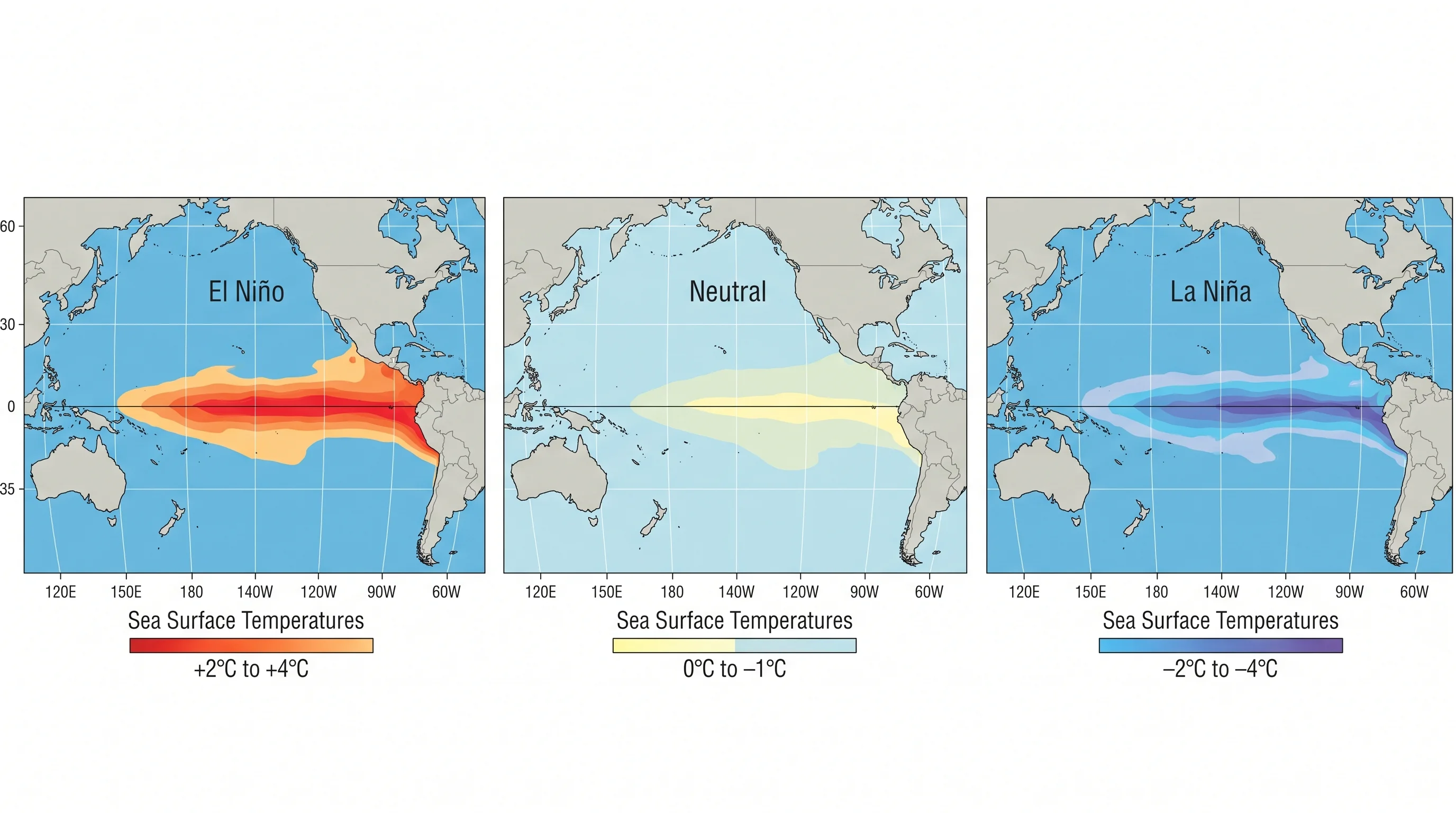
El Niño and La Niña are the two opposite phases of the El Niño Southern Oscillation, or ENSO: a large-scale fluctuation in ocean surface temperatures across the tropical Pacific, centered roughly between the International Date Line and the South American coast. During El Niño, ocean temperatures in this region run warmer than normal, sometimes by as much as 2 to 3 degrees Celsius above the historical average. During La Niña, they run cooler than normal. The neutral phase, when temperatures are near average, is simply called neutral ENSO.
The reason these ocean temperature patterns matter for weather in California, which is thousands of miles from the tropical Pacific, is that they alter the behavior of the jet stream. Warmer-than-normal tropical ocean water changes where and how strongly the jet stream positions itself over the Pacific, which in turn steers storm systems toward or away from California during the winter months. The tropical Pacific is the engine; the jet stream is the transmission; the weather in the Bay Area is what comes out the other end.
NOAA has traditionally tracked ENSO history with the Oceanic Nino Index, or ONI, which follows the three-month average sea surface temperature anomaly in the central equatorial Pacific. Historical warm and cold episodes are often identified when the ONI threshold of positive or negative 0.5 degrees Celsius persists for at least five overlapping three-month seasons. In 2026, NOAA's Climate Prediction Center notes that the Relative Oceanic Nino Index, or RONI, is used for official monitoring and prediction, while ONI remains useful for historical comparison. You can check the current status and forecast at cpc.ncep.noaa.gov.
How El Niño Changes Bay Area Weather
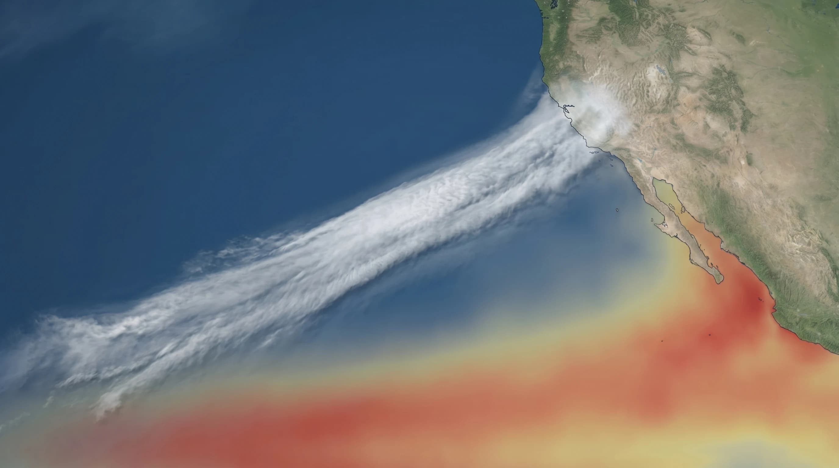
The most important Bay Area effect is winter storm-track risk. El Niño often strengthens the subtropical jet stream and can steer more Pacific storms toward California. When that pattern lines up with warm ocean moisture, storms can arrive as atmospheric rivers: long plumes of water vapor that deliver heavy rain, rapid creek rises, urban flooding, and landslide risk. The strongest impacts usually occur after soils are already wet, so the second or third major storm in a sequence can be more damaging than the first.
El Niño can also affect the coast. A more energetic Pacific storm pattern raises the odds of big surf, coastal erosion, and high-water problems when winter storms overlap with king tides. Warmer-than-normal ocean water can reduce some summer fog tendencies, but that signal is weaker and more local than the winter storm signal. For 2026, the practical Bay Area takeaway is to watch the late-fall and winter outlooks, not to expect every season this year to behave differently.
How Past El Niños Have Hit the Bay Area
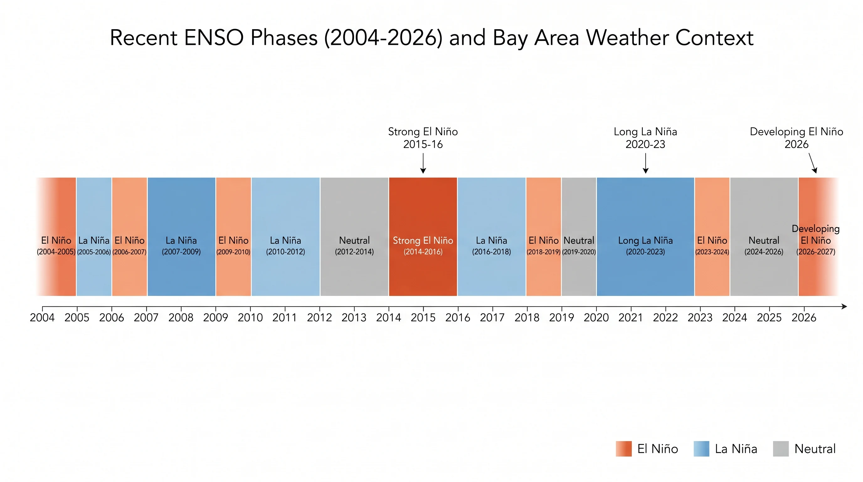
The 1997-98 El Niño is the Bay Area reference case because it delivered repeated storms, flooding, landslides, and major infrastructure strain. The 1997-98 storm season sent the Russian River and smaller creeks high, damaged roads along the coast and in the hills, and made El Niño preparedness a regular part of California winter planning. It is the reason many people still hear "El Niño" and immediately think of sandbags.
The 1982-83 El Niño was another extremely wet California winter, with San Francisco rainfall totals running far above normal and damaging storms across the state. More recently, 2023-24 brought another El Niño with active California storm periods, though the wettest and most damaging impacts leaned heavily toward Southern California. The lesson is not that every El Niño behaves the same. The lesson is that El Niño raises the ceiling on winter storm risk, especially when atmospheric rivers repeatedly find the same part of the coast.
The counterexample is 2015-16. That El Niño was one of the strongest on record in the tropical Pacific, but Northern California did not get the 1997-98 repeat many people expected. Storms did not repeatedly focus on the Bay Area and Northern California at key moments. For the Bay Area, 2015-16 is the caution label on every 2026 outlook: a strong El Niño can increase risk without guaranteeing a locally historic rain year.
El Niño vs. an Average Bay Area Year
Compared with an average Bay Area year, El Niño mainly changes the upper end of the winter-risk distribution. A normal winter can still bring a few strong storms, and an El Niño winter can still miss the Bay Area. But when El Niño is strengthening into winter, the months that already carry the most rain risk, December through February, become the ones to watch most closely.
How La Niña Is Different
La Niña is different, but not simply opposite in every Bay Area winter. A classic La Niña pattern shifts the Pacific storm track north, favoring the Pacific Northwest and often leaving central and southern California drier. The Bay Area sits near the transition zone, so its signal is messier: many La Niña winters are dry, but some still deliver major atmospheric rivers when the jet stream lines up over Northern California. During the extended La Niña period from 2020 to 2022, California experienced severe multi-year drought, with reservoir storage dropping to crisis levels and statewide water conservation measures returning. But the very wet 2022-23 winter unfolded while La Niña was still lingering, which is another reminder that ENSO is only one ingredient in California storm seasons.
When La Niña contributes to a drier winter and spring, the weather can feel sunnier and warmer earlier in the year, especially inland. That can make spring and fall outdoor weather pleasant, but it also means less soil moisture entering the dry season. The tradeoff is important: pleasant shoulder-season weather and drought risk can come from the same dry pattern.
Fire weather is also part of the dry-pattern picture. Drier-than-normal winters leave vegetation with less soil moisture heading into summer, and warm springs can accelerate vegetation dry-out. By fire season in late summer and fall, those fuel and soil-moisture conditions can amplify fire spread when the Diablo winds arrive. The 2020 fire season, which included the SCU Lightning Complex, showed how dangerous dry fuels, lightning, heat, and wind can become even without a simple one-to-one ENSO explanation.
How Long the 2026 El Niño Could Matter
El Niño and La Niña events often last about a year, though some persist longer. Multi-year La Niña episodes are more common than multi-year El Niños, and the 2020-23 La Niña was unusual in lasting across three winters. The 2023-24 El Niño faded, 2025 brought a cool-to-neutral stretch, and the new 2026 El Niño developed after that. NOAA's Climate Prediction Center issues a monthly update that includes current ocean and atmosphere evidence plus a probabilistic forecast for how ENSO is likely to evolve over the next 6 to 12 months.
For seasonal planning, the key period is fall 2026 through winter 2026-27. If El Niño continues strengthening into that window, Bay Area residents should assume a higher-end storm season is possible: clear gutters, inspect drains, trim risky limbs, understand local flood routes, and follow official forecasts when atmospheric rivers appear in the medium-range models. Preparation is useful even if the final rainfall total ends up merely normal.
How to Check the Current ENSO Status and What It Means for Your Plans
The primary resource is NOAA's Climate Prediction Center, especially its monthly ENSO Diagnostic Discussion. The page publishes the current status, the ocean and atmosphere evidence behind it, and the probabilistic forecast for the months ahead. NOAA's seasonal outlook maps are the next step because they translate the ENSO pattern into odds for above-normal, below-normal, or equal-chance precipitation and temperature.
The California Department of Water Resources is also worth watching during the fall and winter, especially for snowpack, reservoir storage, runoff, and statewide water-supply conditions. NOAA is the better source for ENSO status itself; DWR is the better source for how the season is actually translating into California water supply.
What ENSO status does not tell you is what any specific week of weather will look like. El Niño raises the probability of a wet winter, but a wet winter can still have a dry January. La Niña can shift storms away from California, but a Category 4 atmospheric river can arrive in any ENSO phase. The value of ENSO forecasting is in seasonal and multi-month planning: knowing that this winter may lean wetter than normal, or that a dry signal deserves attention, and adjusting your expectations and plans accordingly. In a region where the weather varies as dramatically as the Bay Area's, that kind of calibrated probability is about the most useful forecast that science can reliably provide.