seasonalsafetyclimate science

The 1997-98 El Niño: When Storms Pounded the Bay Area

By SFBayWeather||Updated |6 min read
The 1997-98 El Niño: When Storms Pounded the Bay Area

Key Takeaways

  • The 1997-98 El Niño was the strongest of the 20th century and delivered Bay Area storm sequences in January and February 1998 that were among the most intense in modern regional history.
  • The Russian River rose to record levels, inundating Guerneville and requiring evacuation of thousands of Sonoma County residents.
  • Hillside failures were extensive across the Berkeley Hills, Marin Headlands, Santa Cruz Mountains, and Marin Coast, closing highways and destroying infrastructure.
  • El Niño winters produce above-average rainfall in the Bay Area concentrated in intense events rather than distributed moderate rain, making individual storms more extreme than the seasonal average suggests.
  • The 1997-98 event prompted significant investment in Bay Area flood control and emergency preparedness that changed how the region prepares for El Niño forecasts.

The 1997-98 El Niño was the strongest such event recorded in the 20th century, and California experienced it at full force. The Bay Area was hit by a series of storms between January and March 1998 that were among the most intense in the region's modern weather history. Atmospheric rivers arrived in waves. Hillsides failed. Rivers flooded. Tens of thousands of people were evacuated. Infrastructure across the region was damaged or destroyed. The El Niño of 1997-98 was not merely a wet winter; it was a stress test of the Bay Area's flood control capacity, its hillside development patterns, and its emergency response systems, and it revealed weaknesses that the region has been working to address in the decades since.

How El Niño Affects Bay Area Weather

El Niño is a periodic warming of the central and eastern Pacific Ocean that shifts the pattern of the jet stream and storm tracks. In normal years, the jet stream across the Pacific tends to track toward the Pacific Northwest, delivering storms primarily to Oregon and Washington. During El Niño events, the jet stream shifts south, directing storms toward California and, particularly, toward the Bay Area and Southern California. The storms themselves become more intense: a southward-shifted jet stream has more energy in the subtropical position, and the warmer Pacific during El Niño provides more moisture for the storms to carry.

Strong El Niño winters in the Bay Area are characterized by above-average rainfall concentrated in very intense events rather than distributed moderate rainfall. The 1997-98 event produced roughly twice the normal annual rainfall in some Bay Area locations, but most of that rainfall came in a few catastrophic storms rather than an extended drizzly wet season.

Bay Area storm damage from El Niño 1998: flooding in a neighborhood street, debris flow on a hillside road, emergency vehicles in floodwaters
The 1997-98 El Niño delivered the Bay Area's most intense storm sequence in modern history. Hillside failures, flooded neighborhoods, and overwhelmed creeks caused billions in damage across the region.

The 1998 Storms: Damage and Flooding

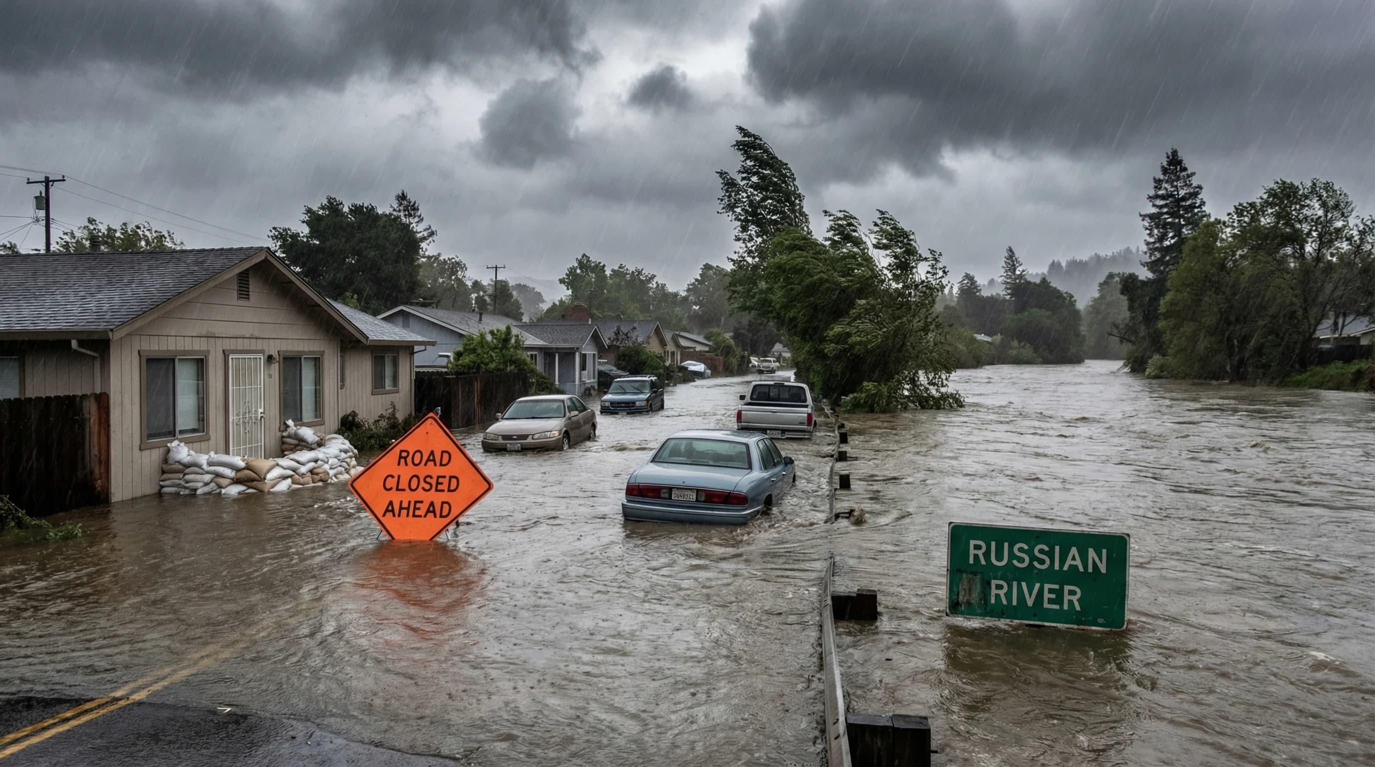
The worst storms of the 1997-98 El Niño hit the Bay Area in January and February of 1998. The Russian River in Sonoma County, which routinely floods in wet years, rose to record levels that inundated the town of Guerneville and required the evacuation of thousands of residents. The storm total at Guerneville, which sits at a bend in the river where water concentrates, reached levels not seen since the 1982-83 El Niño event.

Scientific illustration explaining The 1997-98 El Niño: When Storms Pounded the Bay Area

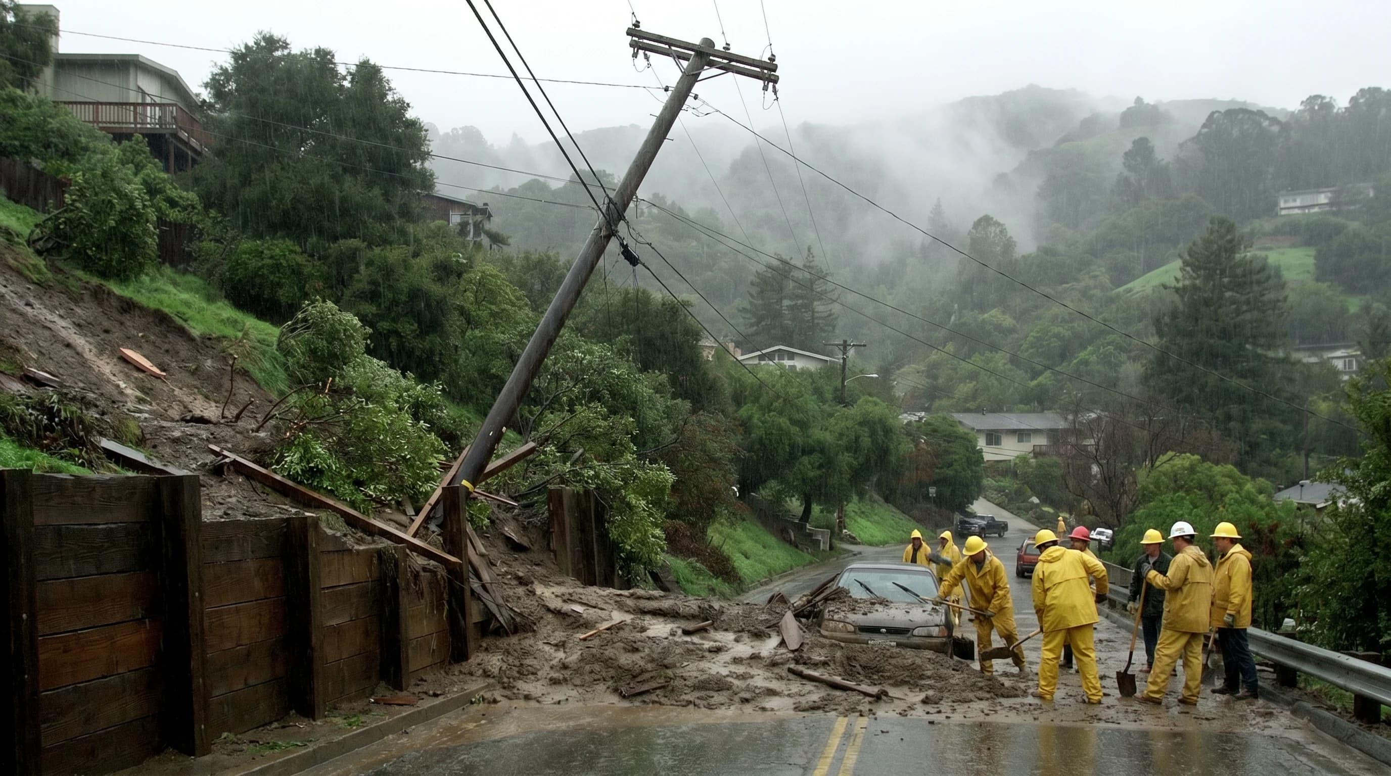
Hillside failures were extensive across the region. The combination of saturated soils from weeks of above-normal rainfall and then intense atmospheric river events produced landslides and debris flows throughout the Berkeley Hills, the Marin Headlands, the Santa Cruz Mountains, and the Marin Coast. Highway 1 along the Marin and San Mateo coasts was closed multiple times by slide debris. Portions of Highway 17 through the Santa Cruz Mountains were blocked. The cumulative infrastructure damage across the Bay Area from the 1997-98 El Niño was estimated in the billions of dollars.

Lessons from 1997-98 and the Next El Niño

The 1997-98 El Niño prompted significant investment in Bay Area flood control and emergency preparedness. Creek and channel improvements were made throughout the region. Hillside development regulations were reviewed. The National Weather Service expanded its warning systems for atmospheric river events and major storm sequences. When strong El Niño events were forecast in subsequent years, particularly the 2015-16 event, which arrived with predictions of a repeat of 1997-98, the Bay Area mobilized in ways that reflected the 1998 lessons. The 2015-16 event ultimately underperformed its forecasts, but the 2022-23 winter provided a reminder: an active atmospheric river year can still overwhelm Bay Area flood control, as flooding at places like the Pajaro Valley demonstrated.

El Niño events are not uniformly wet for the Bay Area. Some strong El Niños, including 2015-16, produce less rainfall than expected at the latitude of the Bay Area while delivering intense storms further south. The relationship between El Niño strength and Bay Area rainfall is real but imperfect, and the variability within El Niño winters is wide enough that any individual El Niño season should be approached with both preparation and humility about specific predictions.

Frequently Asked Questions

How does El Niño affect Bay Area weather?

El Niño is a periodic warming of the central and eastern Pacific that shifts the jet stream southward, directing more storms toward California. In the Bay Area, El Niño winters are characterized by above-average rainfall concentrated in very intense storm events. The storms are often more severe than in non-El Niño years, carrying more moisture from the warmer Pacific and arriving more frequently along the southern jet stream track. Not all El Niño winters are equally wet; the relationship between El Niño strength and Bay Area rainfall is real but variable.

What happened to the Russian River during the 1998 El Niño?

The Russian River rose to near-record levels during the 1998 El Niño storms, flooding the town of Guerneville and surrounding Sonoma County communities. Thousands of residents were evacuated. The flooding was among the most severe since the 1986 El Niño. Highway 116 and other roads in the Russian River valley were closed. The flooding lasted for multiple days, and cleanup and restoration took months.

Was the 1997-98 El Niño the strongest ever?

The 1997-98 El Niño was the strongest on record as measured by sea surface temperature anomalies at the time. It has since been rivaled by the 2015-16 El Niño in some measurements, though that event underperformed its rainfall expectations for much of California. A comparable event in 2023-24 brought significant rainfall to California but was more focused on Southern California than the Bay Area. Periodic strong El Niño events are a natural feature of the Pacific climate system.

What made the 1997-98 El Niño storms so destructive in the Bay Area?

Three factors combined: the El Niño was the strongest of the 20th century, positioning the jet stream to direct intense storm systems directly at Northern California; the storm events were dense atmospheric rivers that delivered 3-6 inches in 24-48 hours; and the storms arrived in close succession, leaving no time for saturated soils to drain between events. The combination produced the conditions most likely to generate flooding and hillside failures: extreme intensity on saturated ground with no antecedent dry period.

How does the Bay Area prepare differently now after the 1997-98 El Niño?

The 1997-98 event and the 1986 El Niño before it prompted significant investment in Bay Area flood management. The Russian River communities have built improved flood monitoring and warning systems. NOAA improved seasonal El Niño forecasts, allowing emergency managers to prepare months in advance when a strong El Niño is predicted. Several Bay Area flood control districts have invested in creek channel widening and levee upgrades specifically to handle the kind of intense events that 1997-98 produced. El Niño forecasts now trigger pre-emptive emergency preparedness statewide.

Live Bay Area Conditions

Compare fog, temperature, wind, and comfort across the map.

See which microclimates are clear, cool, windy, or warming up right now.

Open the Weather Map
🔒Privacy Policy📄Terms of Service