The Bay Area sits at the intersection of several flooding risk factors that are not always visible on a sunny day: bay shoreline subject to tidal flooding and sea level rise, creek and river corridors that overflow during intense winter storms, hillside neighborhoods vulnerable to debris flows after heavy rain, and low-lying areas that collect water from overwhelmed storm drains. Knowing where flood risk is highest, and what type of flooding threatens each area, matters for Bay Area residents, home buyers, and anyone spending significant time outdoors during the winter storm season.
The Four Types of Bay Area Flooding
Bay Area flooding does not come from a single source. Four distinct flooding types affect different parts of the region, and understanding which type threatens a given area changes what to watch for and how to prepare.
The first is creek and river flooding: overflow from the region's many creeks and rivers when storm systems deliver more precipitation than drainage systems can handle. Coyote Creek in San Jose floods roughly once per decade when the reservoir above it fills and spills. Petaluma River rises regularly in heavy winters. Alameda Creek has extensive floodplain zones. These events are predictable in location if not in timing: the same creek corridors flood repeatedly.
The second is tidal and coastal flooding along the bay shoreline, where low-lying areas are vulnerable to high tides combined with storm surge. Communities built on bay fill, including parts of Alviso, Foster City, and portions of the East Bay industrial waterfront, are periodically flooded by king tides combined with storm rainfall and onshore winds. Sea level rise is increasing the frequency and severity of this type of flooding.
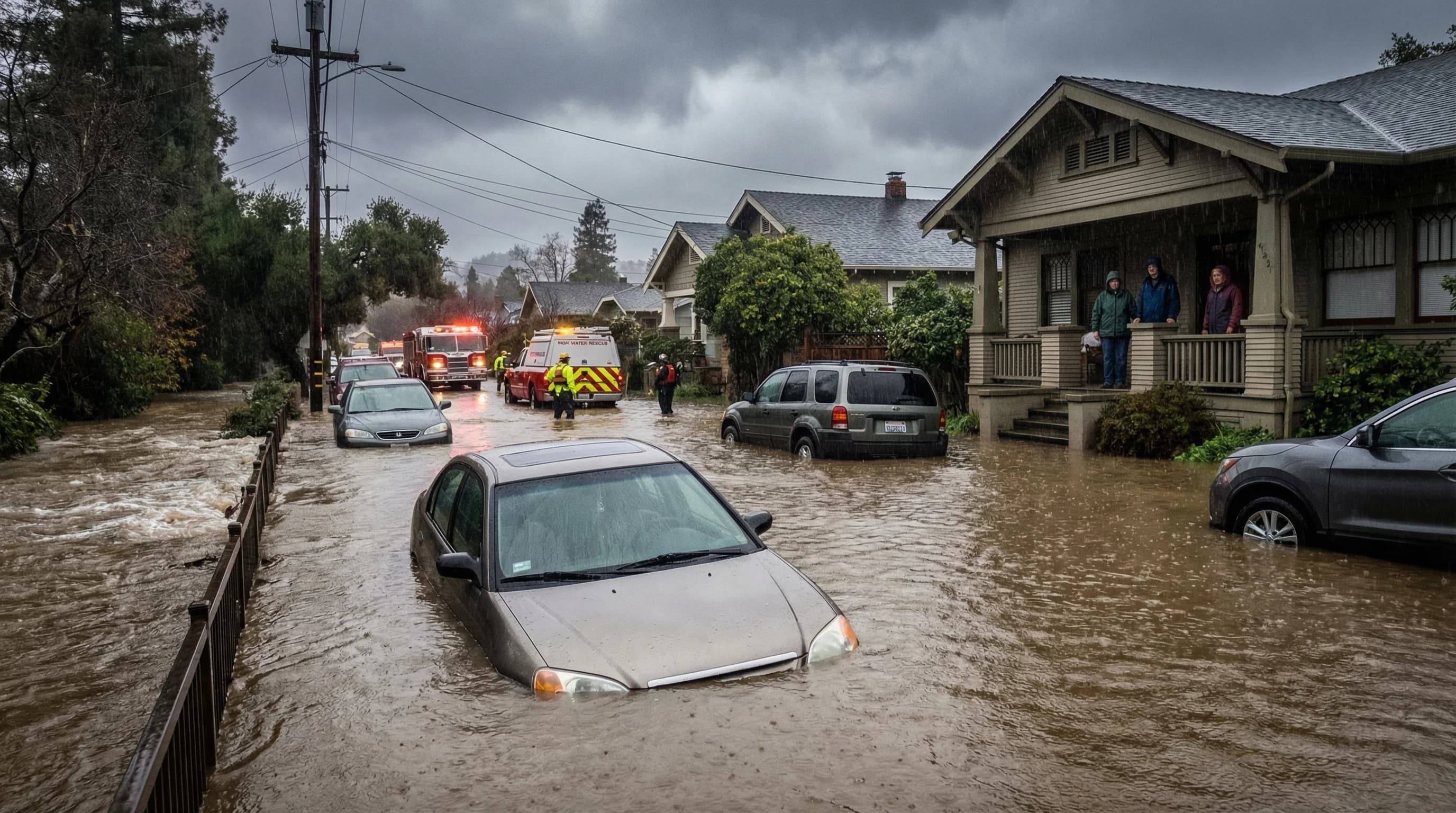
The third is urban stormwater flooding, where overwhelmed storm drain systems back up onto streets and into low-lying properties. This is the most common everyday flooding experience in dense Bay Area communities during intense rain events. Streets in the Outer Sunset of San Francisco, low-lying portions of Oakland, and older communities with undersized storm infrastructure are susceptible.
The fourth is debris flow and landslide flooding on steep terrain, where saturated hillsides send mud, rock, and water downslope. This is the most dangerous flood type in the Bay Area: debris flows can be fast-moving, unpredictable in direction, and powerful enough to destroy structures. The Santa Cruz Mountains, Marin headlands, and Oakland hills have all experienced significant debris flow events in recent years.
Bay Area Communities at Highest Flood Risk
FEMA flood zone maps identify Special Flood Hazard Areas (SFHAs), which are defined as areas with at least a 1-in-100-year annual flood chance. In the Bay Area, the highest-risk FEMA zones include Alviso (in the South Bay, one of the lowest-elevation communities in the region), portions of East Palo Alto near the bay shoreline, low-lying areas of San Jose along Coyote and Guadalupe creeks, the Napa River corridor in Napa County, and the Petaluma River floodplain. These areas are in designated flood zones and require flood insurance for federally backed mortgages.
Beyond FEMA's 100-year flood zones, the Bay Area has extensive areas at risk from the types of flooding FEMA maps do not always capture well: urban stormwater flooding in areas with undersized drainage, climate-driven flooding from sea level rise, and debris flow risk on slopes above a certain steepness and soil saturation level. The most vulnerable hillside neighborhoods for debris flow include the upper Oakland hills scarred by the 1991 Oakland Hills firestorm, Marin County hillsides with fire history, and the Santa Cruz Mountains above Highway 17.
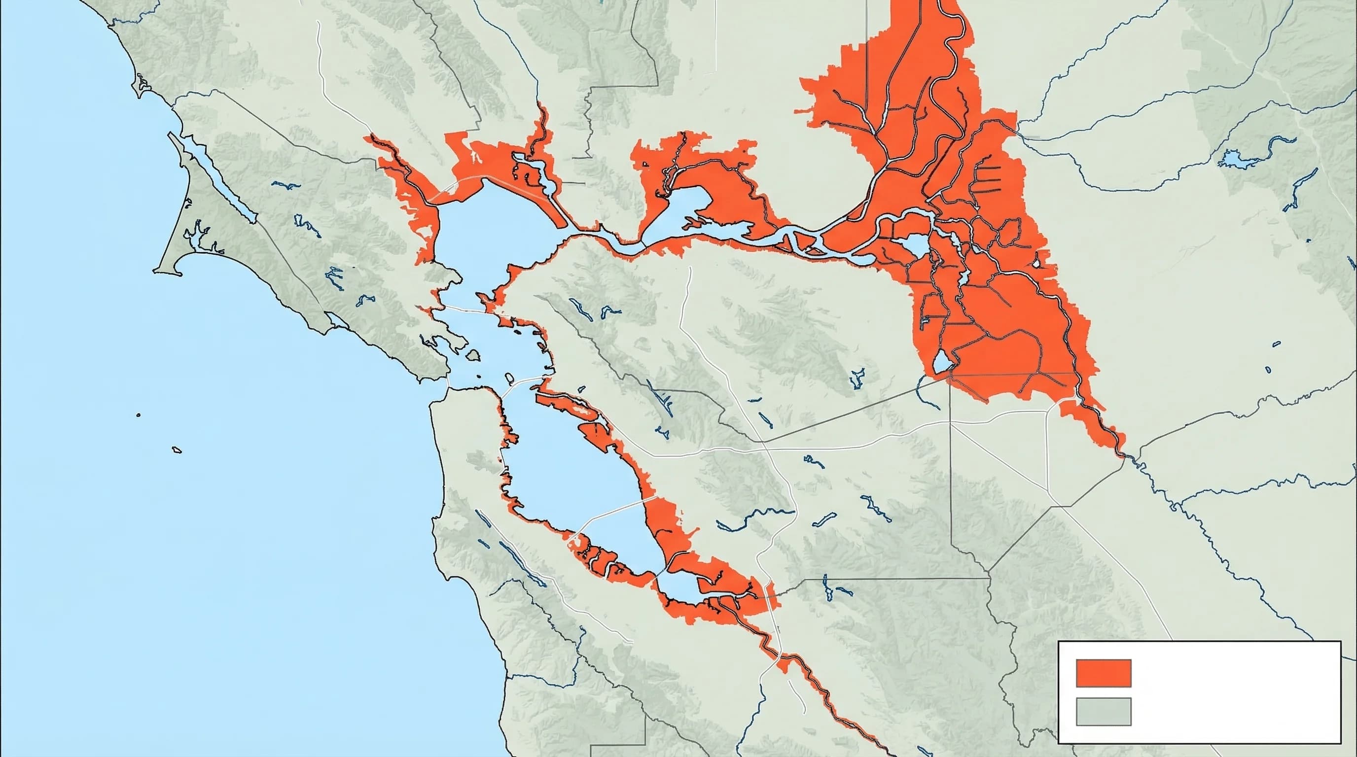
Sea Level Rise and Bay Shoreline Flooding
Approximately 70,000 to 90,000 Bay Area residents live in areas projected to be regularly flooded by 2100 under moderate sea level rise scenarios, according to SFEI (San Francisco Estuary Institute) research. Low-lying bay shoreline communities including portions of San Mateo, Redwood Shores, Foster City, Alviso, and portions of Richmond and Oakland are within the projected flood zone for 24-inch sea level rise scenarios, which represent the middle range of scientific projections for the region by end of century.
The bay shoreline flooding risk is compounded by the fact that many of these communities were built on bay fill, land that was literally created by filling shallow bay areas with soil. Bay fill land is often at elevation barely above current sea level and sits on soft sediment that can amplify shaking during earthquakes and contributes to slower subsidence over time.
How to Check Your Flood Risk
The starting point for checking flood risk at a specific address is FEMA's Flood Map Service Center at msc.fema.gov. Enter your address to see the official FEMA flood zone designation. Zone AE indicates high risk and the highest likelihood of required flood insurance. Zone X indicates lower risk areas outside the 100-year floodplain.
For Bay Area-specific flood risk including sea level rise projections, the SFEI Adapting to Rising Tides project maintains regional mapping tools with flood scenarios through the end of the century. Cal Fire's viewer shows historical fire perimeters relevant to debris flow risk assessment. USGS provides landslide hazard maps for steep terrain throughout the region.
For storm event planning, the Bay Area's county offices of emergency services maintain flood evacuation maps and real-time creek level data during storm events. Contra Costa County, Santa Clara County, and Marin County all publish specific flood-prone road lists that are closed during major storms. Knowing whether your route crosses any of these flood-prone points is essential preparation for Bay Area winter travel.
What to Do When Flood Warnings Are Issued
NOAA issues Flood Watches when conditions are favorable for flooding and Flood Warnings when flooding is imminent or occurring. A Flash Flood Warning is the highest severity, indicating fast-moving dangerous flooding. In the Bay Area, Flash Flood Warnings are typically associated with debris flow risk on steep terrain and rapid creek rises during intense rainfall.
When flood warnings are issued, avoid crossing any flooded road or creek, even if the water looks shallow. Six inches of moving water is sufficient to knock a person off their feet; 12 inches can carry away small vehicles. Do not attempt to drive through flooded underpasses, which can fill rapidly and trap vehicles underwater. Move vehicles to higher ground before a storm if you live in a known flood zone, and be aware of emergency evacuation routes that avoid flood-prone areas.