Elevation determines whether you are above the fog or beneath it, inside the marine layer or above it looking down. In the Bay Area, the difference between 500 feet and 1,500 feet of elevation can be the difference between a gray, 55-degree morning and a warm, sunny one. That interaction between elevation and fog is one of the most distinctive features of Bay Area life: some of the most desirable real estate in the region is determined not by views alone but by how often those hillside homes sit in sunshine while the flatlands below are buried in fog.
The Marine Layer and Its Ceiling
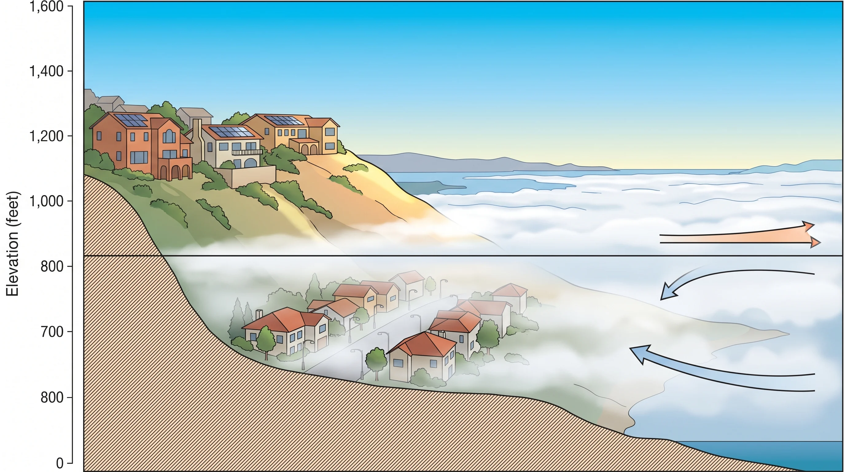
The marine layer is a shallow body of cool, moist air that flows in from the Pacific and settles over the Bay Area during summer. It is not uniform in depth. The marine layer has a ceiling, the temperature inversion base, above which warm, dry subsidence air from the descending North Pacific High prevents the fog from rising. This ceiling is the critical number for understanding fog and elevation.
When the inversion base is at 800 feet, most of San Francisco, Oakland, and the peninsula flatlands are buried in fog, but the Berkeley Hills above 900 feet are in sunshine. When the inversion base is at 1,500 feet, only low-lying coastal areas stay fogged in, and most hillside neighborhoods are clear. When the inversion is very low, 400 or 500 feet, even the low Berkeley Hills are fogged, and only the highest East Bay ridges above 1,500 feet are consistently above it. The weather forecast phrase "fog below 1,000 feet" translates directly into a map of who will wake up to sun and who will wake up to gray.
Which Elevations Escape Bay Area Fog
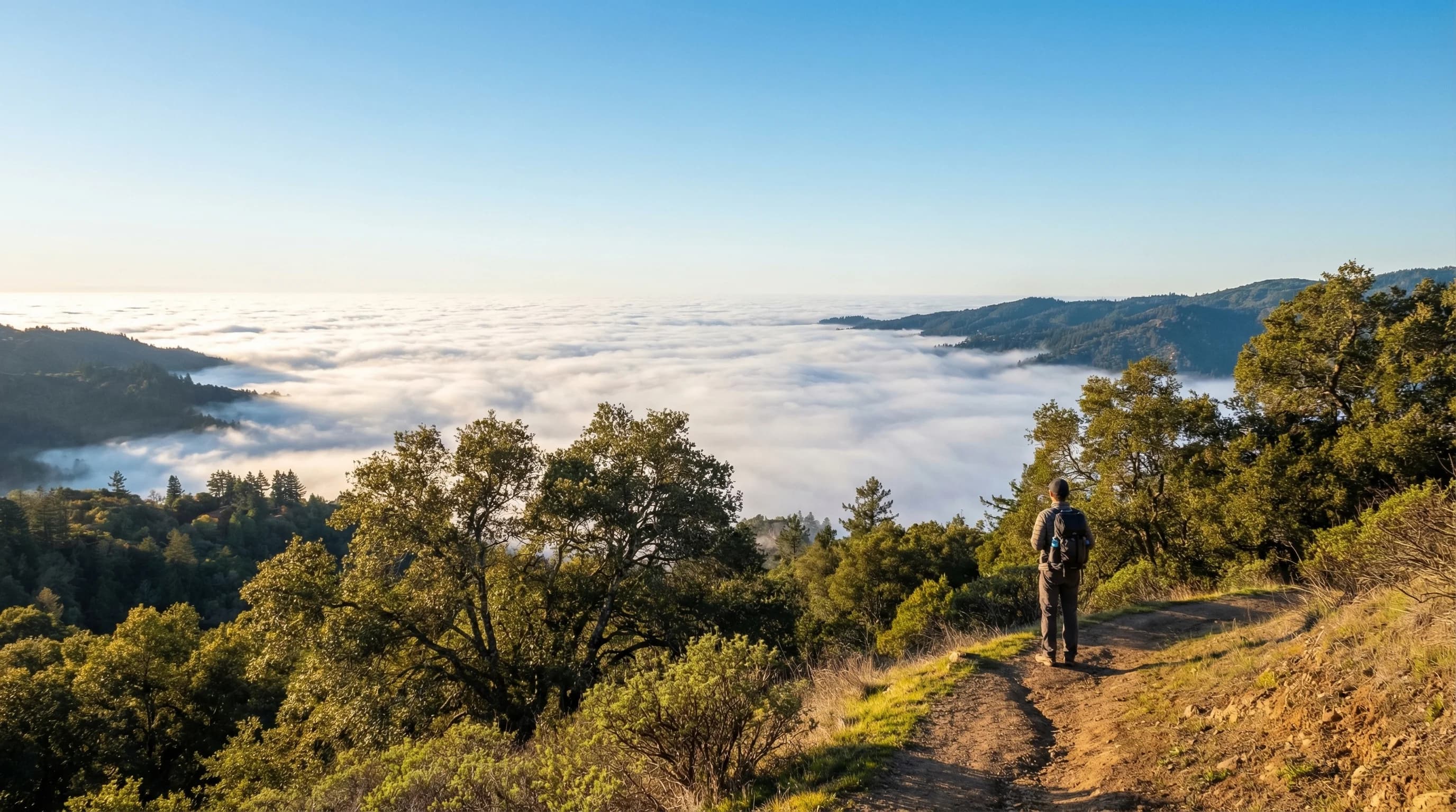
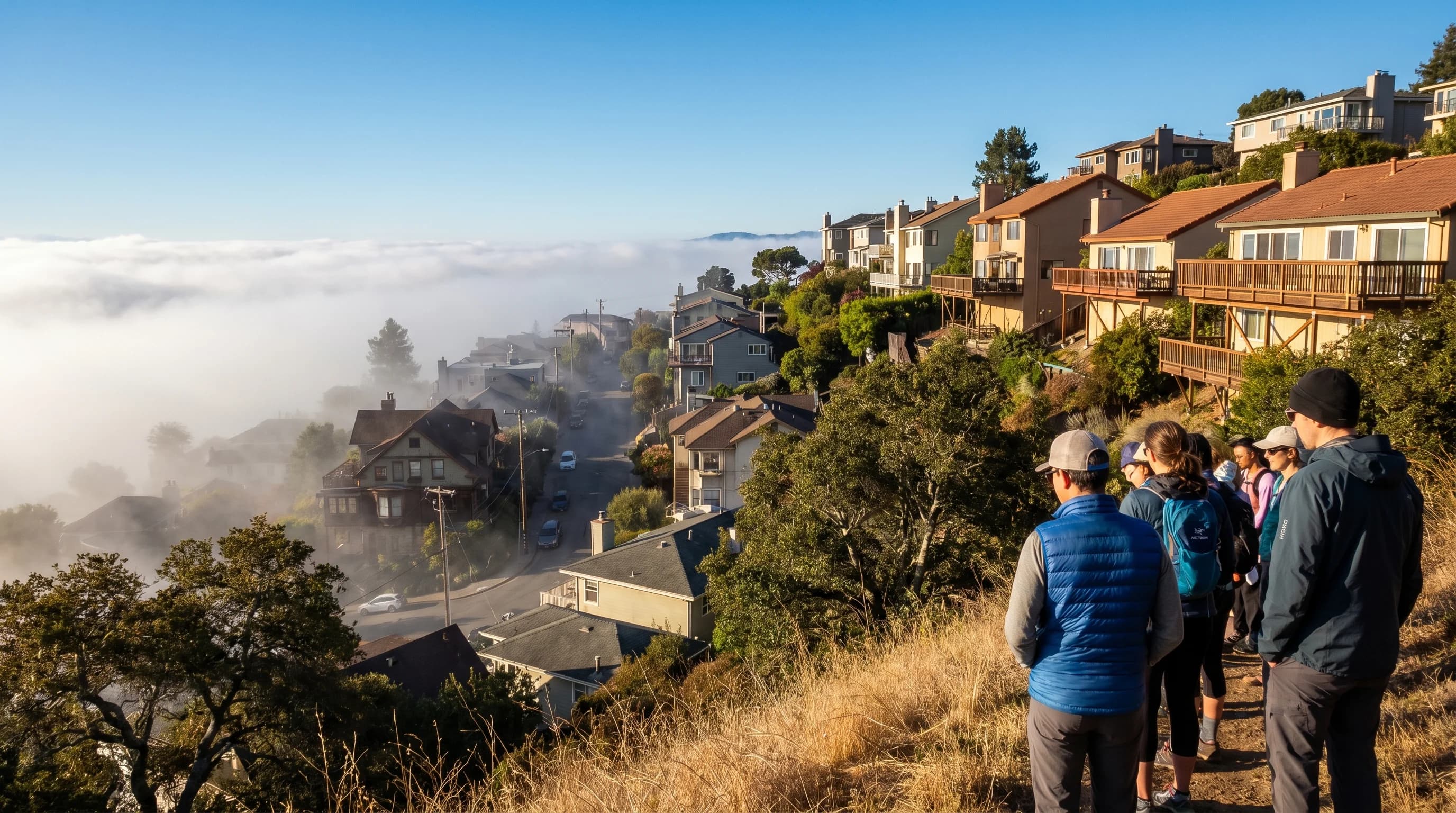
In San Francisco, the fog ceiling on most summer mornings is below the height of the city's hills. Twin Peaks (922 feet), Mount Davidson (925 feet), and the upper parts of the Sunset District ridgeline often poke above or near the inversion base. Neighborhoods like Forest Hill, West Portal, and the upper Castro are frequently above the densest fog layer, even when the flatlands are completely socked in. This is why residents who live in these neighborhoods sometimes describe having fog in the morning on the lower streets and sunshine on their block; they are literally above the fog ceiling.
In the East Bay, the Berkeley Hills begin at about 800 feet and rise to Grizzly Peak at 1,754 feet. On most summer mornings, the upper Berkeley Hills above 1,200 feet are reliably above the marine layer. The communities of Orinda, Moraga, and Lafayette on the east side of the hills are in a different fog world entirely, shielded from coastal fog by the hills themselves and too far inland for the marine layer to typically reach. In Marin, the ridgelines of Mount Tamalpais above 2,000 feet are almost always above the fog, but the valleys below can be completely buried on peak marine push days.
Elevation, Temperature, and the Inversion
Normal atmospheric conditions would produce cooler temperatures with increasing elevation, at the standard lapse rate of about 3.5 degrees Fahrenheit per 1,000 feet. Within the marine layer, this is broadly true. But at and above the inversion base, temperature reverses; the air above the inversion is warmer than the fog below it. This is why a thermometer at a summit above the marine layer reads warmer than one at the foggy valley floor, even though the summit is higher.
This creates an unusual situation: on a typical July morning in the Bay Area, a hiker on the Berkeley Hills at 1,500 feet may be standing in 72-degree sunshine, while people in downtown Berkeley at sea level are experiencing 58 degrees and dense fog. The temperature increases with altitude, which is backward from the normal atmosphere. Once the sea breeze kicks in and burns off the fog in the afternoon, the temperature relationship normalizes; the higher elevation cools back down below the lowland temperatures, as expected. The morning inversion creates a temporary upside-down world.
Fog Drip and High-Elevation Moisture
The highest elevations in the Bay Area have a relationship with the marine layer that goes beyond simply being above it. When the marine layer cracks or spills over coastal ridges, the fog encounters vegetation at elevation and delivers moisture through fog drip, the process by which fog droplets collide with leaves and needles, coalesce into larger drops, and fall to the forest floor. This process is why the highest coastal ridges support lush redwood forests and dense shrub despite receiving no summer rain: the fog itself is the water source.
Mount Tamalpais above 2,000 feet is immersed in fog drip conditions on more summer days than the lower slopes, even though the summit itself often rises above the fog. The forest at the 1,500-foot level on the mountain's west-facing slopes intercepts the marine layer as it flows over the ridge, capturing moisture that the lower, leeward slopes never receive. In summer, the ecological divide between fog-fed coastal forest and dry interior chaparral can be as narrow as a single ridgeline; and elevation determines which side you are on.