destinationshiking weathermicroclimates

Mount Diablo Weather: Above the Fog, Below the Snow Line

By SFBayWeather||Updated |6 min read
Mount Diablo Weather: Above the Fog, Below the Snow Line

Key Takeaways

  • Mount Diablo's summit at 3,849 feet runs 18-20°F cooler than the base communities (Walnut Creek, Clayton), pleasantly cool when the valley is baking at 92°F.
  • The summit frequently rises above the winter fog layer, producing dramatic "sea of fog" views while the East Bay below is socked in.
  • The mountain is central to the Bay Area's most serious fire weather: Diablo winds accelerate through its passes and canyons, delivering the conditions that drive the region's worst wildfires.
  • Winter storms occasionally deposit snow on the upper slopes, making it one of the few places in the Bay Area where snow is a realistic expectation in cold years.
  • The best summit views occur after winter cold fronts (November-March) and in fall (October), summer haze from the Central Valley significantly reduces visibility.

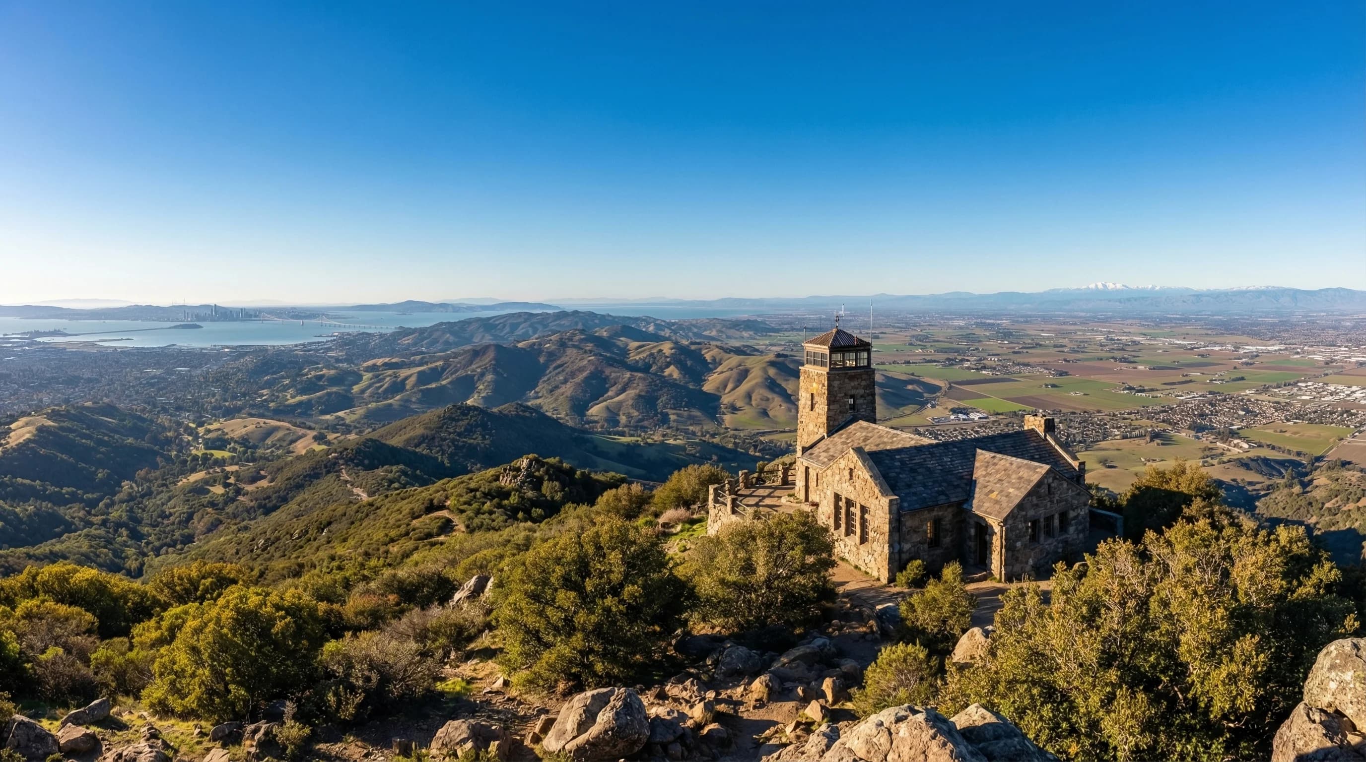
Mount Diablo rises to 3,849 feet at the center of the East Bay, visible from most of the Bay Area on clear days and visible from the Sierra Nevada on exceptional ones. The mountain is the Bay Area's dominant geographic reference point, the peak against which distances and elevations are implicitly measured, and its weather is as distinctive as its appearance. The summit occupies a climate zone entirely different from the surrounding lowlands: cooler in summer, colder in winter, frequently above the marine layer that suppresses coastal temperatures, and occasionally dusted with snow when the rest of the Bay Area is merely cold and wet. A day on Mount Diablo's summit can be among the most dramatic weather experiences the region offers.

Summit Weather vs. the Lowlands

The temperature at Mount Diablo's summit runs approximately 18 to 20 degrees Fahrenheit cooler than at the base, following the standard atmospheric lapse rate. On a July afternoon when Walnut Creek at the mountain's base reaches 92 degrees, the summit is around 72, pleasant and cool, with a breeze. On the hottest days, when Walnut Creek and Concord are suffering at 105, the summit sits in the mid-80s, warm but manageable.

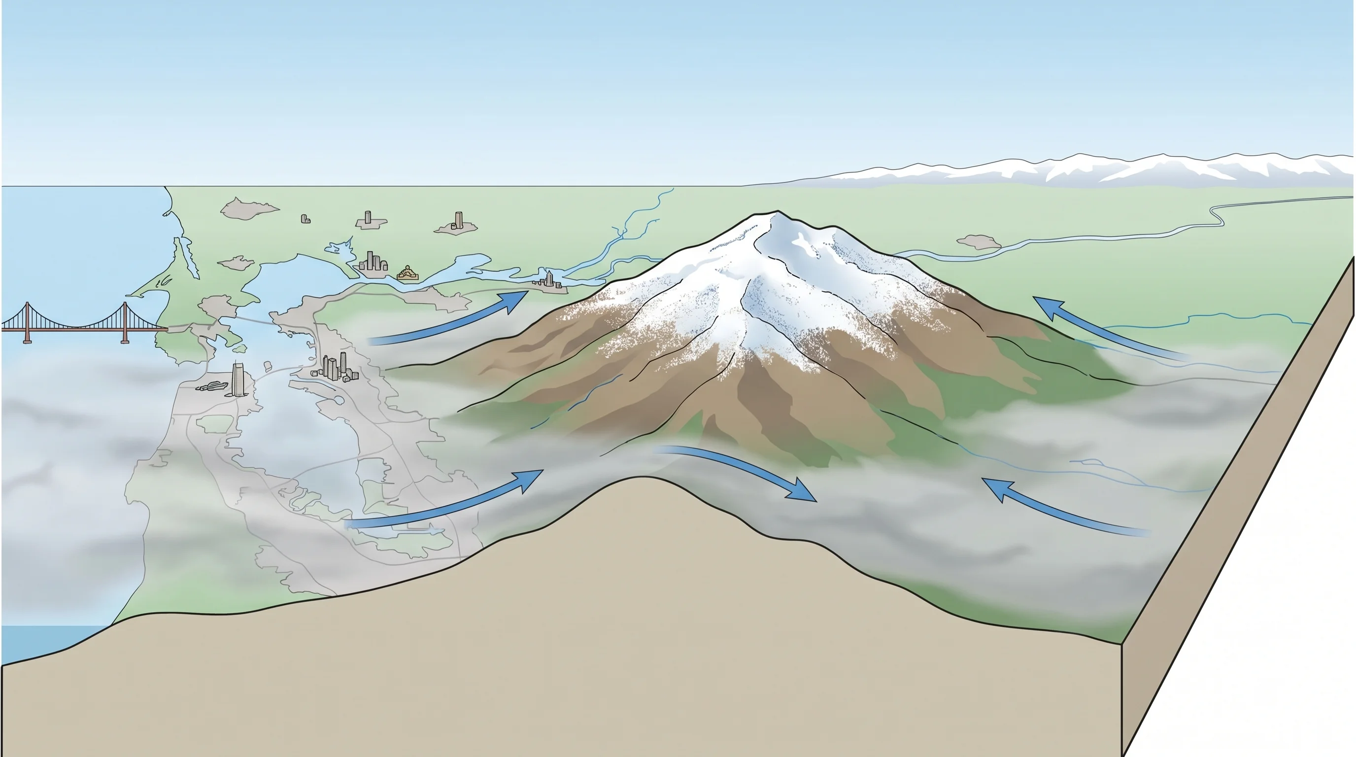
In winter the inversion works the other direction. When cold air pools in the valley floor and the surrounding lowlands are locked in tule fog, the summit often rises into sunshine above the fog layer. This inversion phenomenon, warm summit, cold foggy valley, produces some of the mountain's most striking visual conditions: standing in full sunshine on the summit while looking down at a flat white sea of fog covering the East Bay cities below. The effect is more dramatic on Mount Diablo than on lower peaks because its summit rises high enough above the typical fog ceiling to be fully clear.

Mount Diablo summit rising above a sea of fog covering the East Bay, with clear blue sky above and the fog layer below stretching to the horizon
Mount Diablo's 3,849-foot summit frequently rises above the winter fog layer and the summer marine layer ceiling, offering clear views while the Bay Area below is fogged in.

Wind and Fire Weather

Mount Diablo is the Bay Area's most important weather generator from a fire risk perspective. The Diablo winds that drive the region's most dangerous wildfire conditions originate as offshore flow, hot, dry air from the Great Basin moving toward the coast, but they accelerate dramatically as they move over and around the mountain's flanks. The passes and canyons around Mount Diablo are among the windiest terrain in the East Bay, and the hot, dry Diablo winds that funnel through them in fall can reach 60 to 80 mph during major events.

Scientific illustration explaining Mount Diablo Weather: Above the Fog, Below the Snow Line

The combination of summer drought, which cures the mountain's extensive vegetation to low moisture content, and fall Diablo winds creates one of the Bay Area's highest fire risk environments. Mount Diablo State Park has burned repeatedly in major fires, and the areas around the mountain, Clayton, Danville, Blackhawk, maintain year-round fire awareness that residents of more coastal communities find intense until they've lived through a Diablo wind event.

The Views and When to See Them

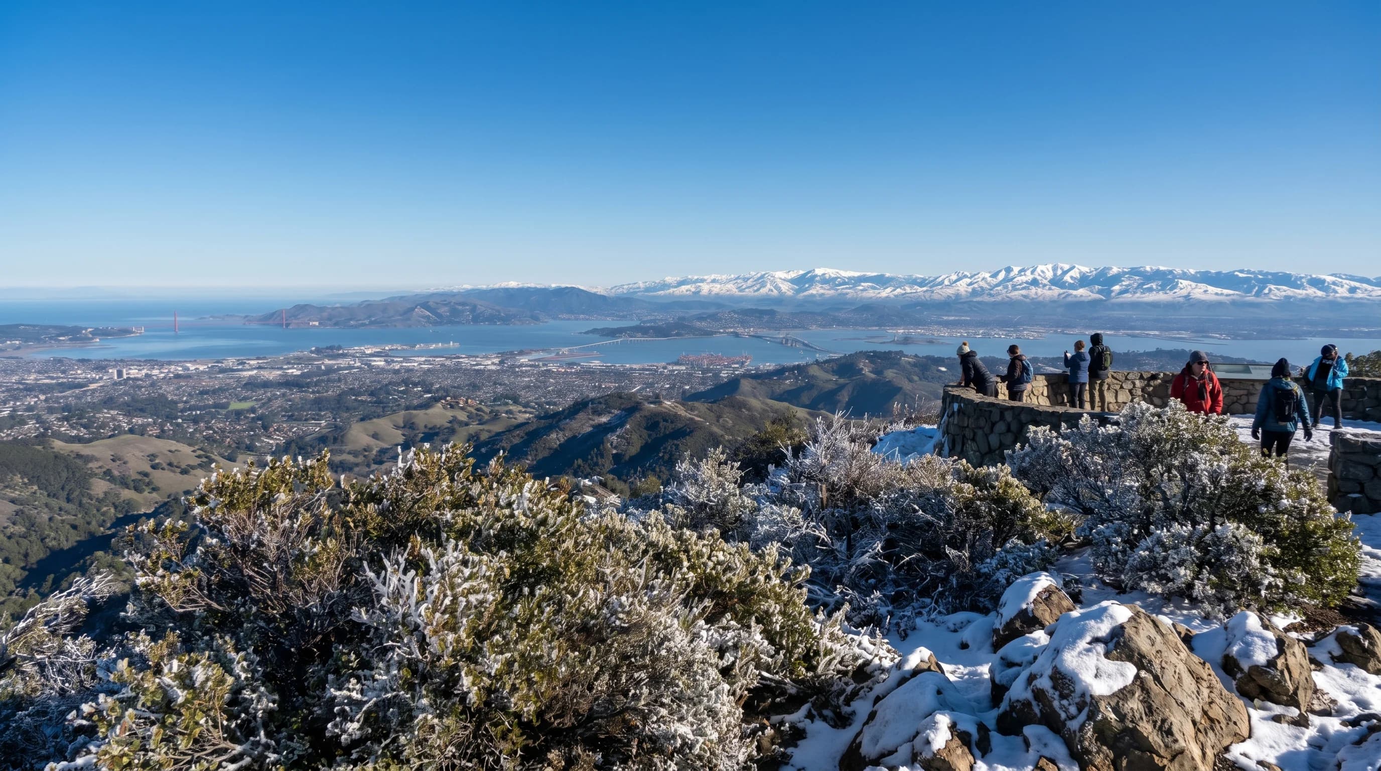
Mount Diablo is famous for the extent of its summit views. On the clearest days, typically in winter after a cold front has swept through, or in fall before the marine layer reasserts itself, the summit view encompasses the entire Bay Area, the Sacramento-San Joaquin Delta, the Central Valley, and the Sierra Nevada from Lassen Peak in the north to beyond Fresno in the south. The summit view on exceptional days can encompass 40,000 square miles of California, one of the most extensive views from any non-volcanic summit in the lower 48 states.

The best months for clear summit views are November, December, and March, after frontal systems have cleared the atmosphere of haze and smoke. October is excellent in years with early rainfall. The worst months for views are July and August, when Central Valley agricultural dust and summer haze reduce visibility significantly even on days with no cloud cover. The summit is also the Bay Area's best vantage point for watching the marine layer push inland in the late afternoon; the fog's progress through the Bay and its penetration of the various passes is visible in real time from 3,849 feet, a perspective that makes the Bay Area's complex microclimate geography immediately comprehensible.

Frequently Asked Questions

What is the weather like on Mount Diablo?

Highly variable by elevation and season. The summit (3,849 ft) is typically 18-20°F cooler than the base. In summer, when Walnut Creek is at 92°F, the summit is around 72°F with a breeze. In winter, the summit can drop below freezing and receives occasional snow. The summit often rises above the winter fog layer, producing clear views while the Bay Area below is socked in.

Can you see snow on Mount Diablo?

Yes, in cold winters. The upper slopes above 3,000 feet occasionally receive snow during strong winter storms when temperatures are cold enough. It rarely lasts more than a day or two before melting, but the spectacle of snow on an East Bay peak visible from throughout the region makes news every time it happens. Snow years are not reliable; some winters see none, others see two or three events.

When is the best time to hike Mount Diablo?

October-November for the best combination of views, comfortable temperatures, and seasonal color. Spring (March-May) for green hills and wildflowers. Early morning in summer to avoid the heat. The summit trail in the afternoon on a 95°F day is genuinely dangerous. Winter is dramatic and views are excellent after fronts clear the atmosphere, but trails can be muddy and snow is possible above 3,000 feet.

Does Mount Diablo rise above the fog on foggy Bay Area days?

Yes, and this is one of the mountain's best features in winter. When the Bay Area's tule fog or marine layer fills the valleys below, the summit often sits in clear air above the fog ceiling. Driving up through the fog layer and emerging into sunshine at 3,000 feet while the East Bay below is invisible is a striking experience. The fog base typically sits between 1,000 and 2,500 feet on winter inversion days, putting the summit clearly above it. Check the forecast for Walnut Creek at the base versus the summit to see if an inversion is in place.

How do Diablo winds affect the mountain and surrounding communities?

Mount Diablo is central to the Bay Area's most dangerous fire weather. The Diablo winds are hot, dry offshore winds that accelerate through the mountain's passes and canyons in fall, delivering single-digit relative humidity to the East Bay hills. These are the conditions that drove the 1991 Oakland Hills fire and other major East Bay wildfires. The mountain itself is closed during extreme fire weather events. Residents in Diablo foothills communities (Clayton, Danville, Concord) receive evacuation warning alerts when fire weather watches are issued.

Related Destinations

Live Bay Area Conditions

Compare fog, temperature, wind, and comfort across the map.

See which microclimates are clear, cool, windy, or warming up right now.

Open the Weather Map
🔒Privacy Policy📄Terms of Service