Here is the fact that surprises almost everyone who visits San Francisco for the first time expecting California summer: June and July are the foggiest months of the year, and January is one of the clearest. This is not a quirk or a statistical anomaly. It is the fundamental character of Bay Area coastal climate, and once you understand the mechanism behind it, the whole regional weather pattern starts to make sense in a way it never did before.
Just How Intense Is Summer Fog?
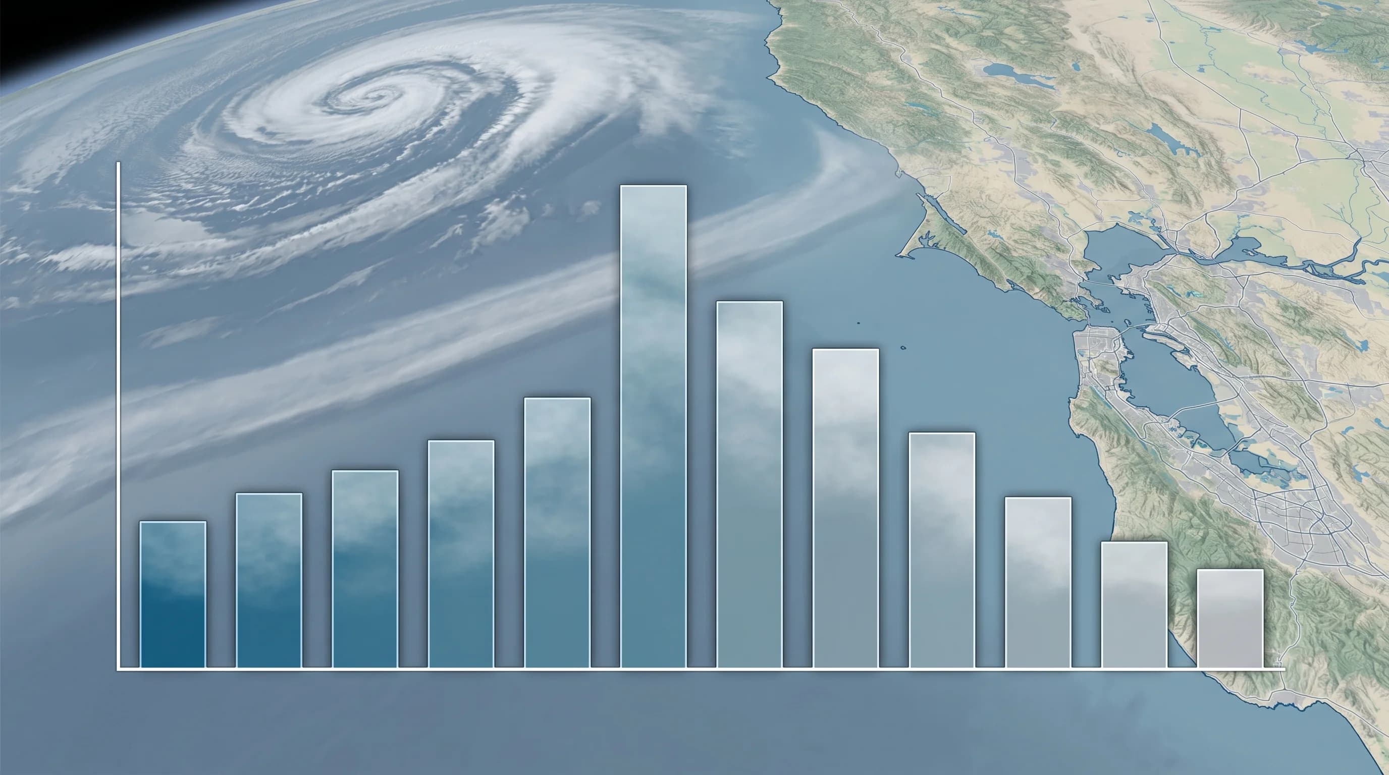
The numbers are stark. June averages 18 to 20 foggy days along the San Francisco coast. July averages 14 to 16. August runs 12 to 14. Compare that to January and February, which average only 6 to 8 foggy days each. Summer fog also tends to be denser: summer visibility frequently drops below 0.5 miles during peak morning fog, while winter visibility in cloudy conditions typically stays at 1 to 3 miles even when the sky is gray. The summer fog is not just more frequent; it is more opaque, lower to the ground, and more persistent through the morning hours.
For people who grew up expecting summer to mean sunshine and winter to mean gray, this pattern feels backwards. But it makes complete sense once you understand what is actually driving the fog, because the driver is not winter cold. It is summer heat.
The Thermal Low: How Inland Heat Creates Coastal Fog
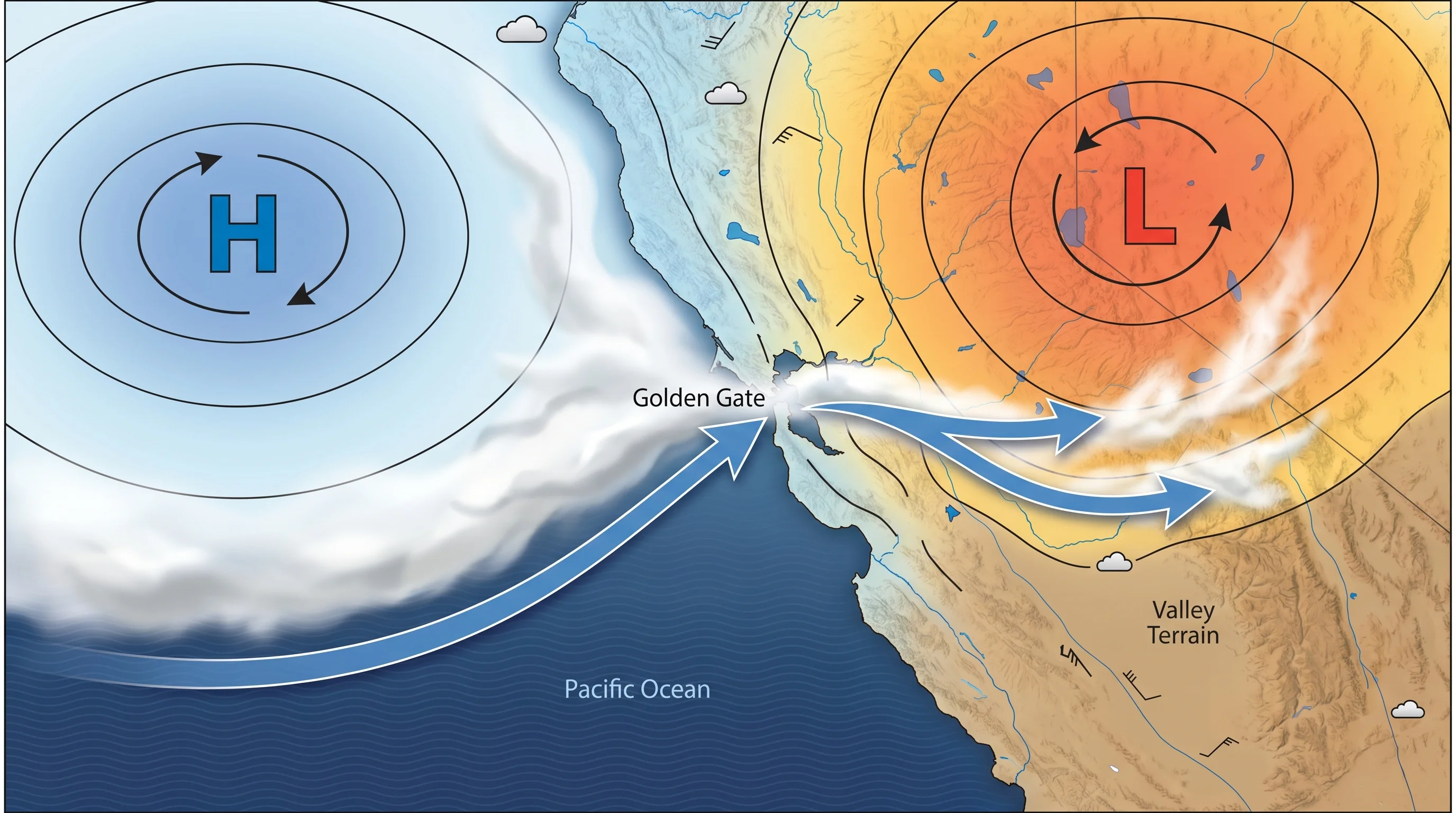
Every summer, California\'s Central Valley becomes a heat sink. Temperatures routinely hit 95 to 105 degrees Fahrenheit across the valley floor. That superheated air rises, creating a persistent thermal low pressure zone over the interior. The Pacific Ocean, meanwhile, sits at 55 to 58 degrees year-round, a product of cold upwelling and the southward-flowing California Current. Dense, cold, high-pressure ocean air wants to flow toward the warm, low-pressure land.
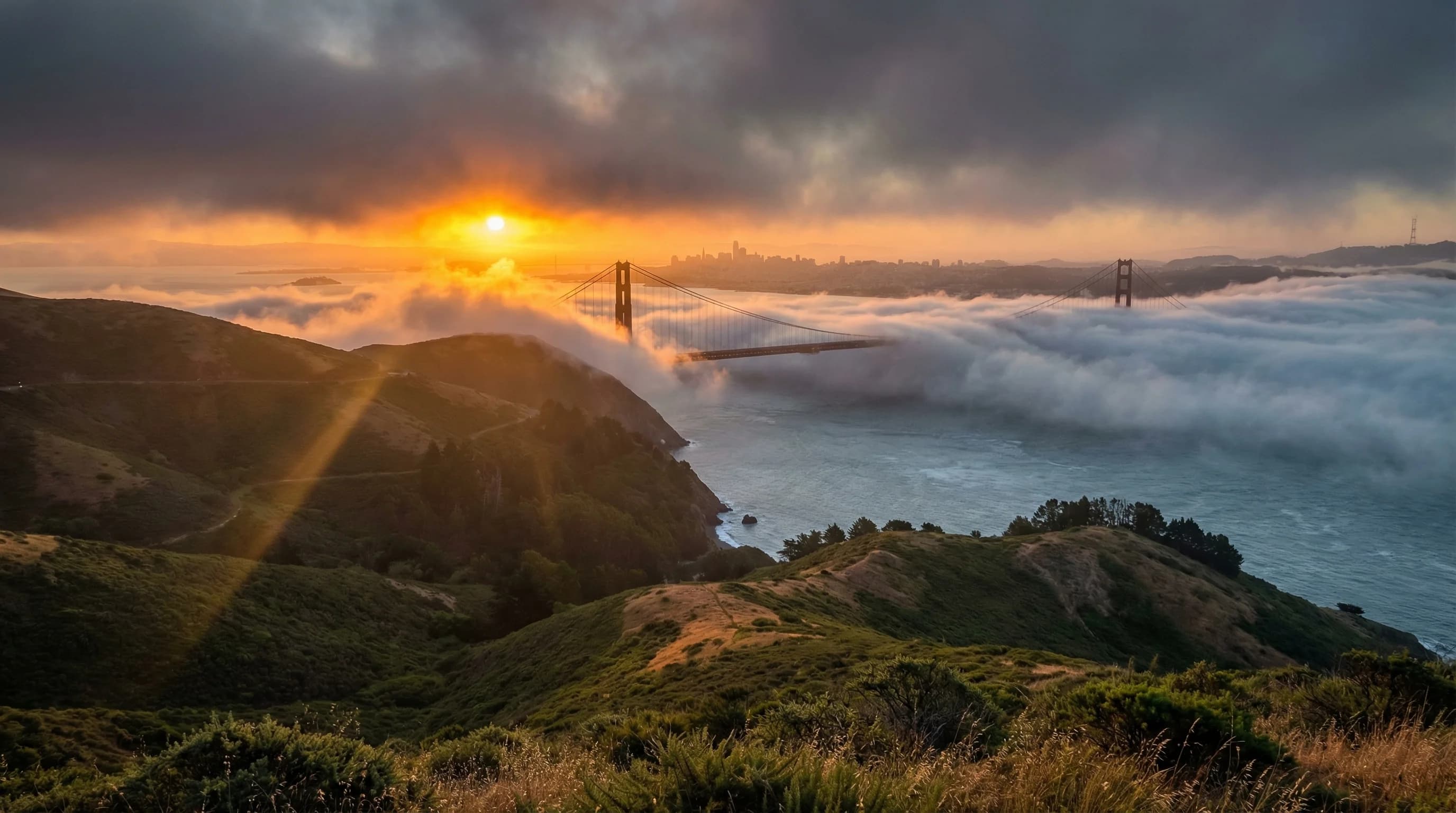
The result is a powerful daily pump. Every afternoon, cool marine air gets pulled through coastal gaps, most dramatically through the Golden Gate, and pushed inland by the pressure gradient. That marine air carries moisture, and as it flows over the cold ocean surface and then onto warming land, it condenses into the fog and low clouds that characterize Bay Area summer afternoons and mornings. The stronger the inland heat, the stronger the pressure gradient, the more aggressively the marine layer gets pulled in. Peak summer heat produces peak summer fog. The mechanism is elegant and completely counterintuitive if you expect summer to mean clear skies.
Why Winter Is Clearer
In winter, the thermal engine shuts down. The Central Valley cools to temperatures in the 40s and 50s, eliminating the pressure gradient that drives marine air inland. There is no longer a strong temperature difference between coast and interior to act as a pump. Marine air still exists offshore, but it sits there without being aggressively pulled through the coastal gaps. San Francisco in January may see clouds, rain, and overcast skies, but these are products of storm systems moving through from the north Pacific, not the same marine layer fog that defines summer.
Winter storms bring entirely different weather than summer fog. They bring wind, rain, and clouds at altitude, but they also bring clearing: the gaps between storms in winter are often bright and crisp, with excellent visibility and genuine warmth in afternoon sun. A clear December afternoon in San Franciscocan be genuinely lovely in a way that a clear August afternoon often is not, because summer's “clear” days are typically followed by afternoon fog rolling back in off the ocean. Winter clearing is often more complete and more stable.
A Season-by-Season Picture
Spring, particularly May and early June, is when the fog machine starts warming up. The Central Valley begins heating, the pressure gradient strengthens, and the marine layer begins its seasonal push inland. May is transitional and can swing between warm sunny spells and the first waves of summer fog. By June, the pattern is locked in.
Late summer and fall represent the most interesting seasonal transition. September is when the fog begins to retreat. The Central Valley starts cooling after the August peak, the thermal gradient weakens, and fog days drop to 4 to 6 per month. October continues the trend and produces what locals call Indian Summer: warm, sunny, genuinely pleasant conditions that deliver the California summer experience most visitors expected in July. October is legitimately the best month in much of the Bay Area, and it is the month that rewards people who plan their visits based on actual climate data rather than what a California summer is supposed to feel like.
The Ocean Temperature Factor
One reason the summer fog is so persistent is that the Pacific Ocean never warms enough to reduce the temperature contrast. In most coastal areas of the world, the ocean warms somewhat in summer, narrowing the gap between sea and land temperatures and reducing fog frequency. Off the California coast, upwelling replaces warm surface water with cold deep water faster than solar heating can warm it. The ocean at 55 to 58 degrees in August is just as cold as it was in February. The temperature contrast between the Pacific and the summer Central Valley is actually at its maximum in June and July, which is exactly when fog frequency peaks. The ocean's refusal to warm is the linchpin of the whole system.
This is also why El Nino years, when the Pacific surface warms slightly, tend to produce somewhat fewer Bay Area fog days. Even a modest sea surface temperature increase of 1 to 2 degrees reduces the temperature contrast and weakens the thermal gradient slightly. In strong El Nino summers, San Francisco can see noticeably more afternoon sun than usual. But the effect is modest compared to the underlying mechanism, and even El Nino summers produce plenty of June fog.
Planning Around This Pattern
The practical implication for anyone visiting or living in the Bay Area is to treat the calendar differently than you would elsewhere. July 4th weekend in San Francisco is historically one of the foggiest, coldest times to be on the waterfront. Visitors in shorts and tank tops standing on Fisherman's Wharf in July fog is one of the most reliable tourism cliches the city produces. If you want outdoor dining, rooftop bars, or beach weather, you are looking for September and October, not June and July.
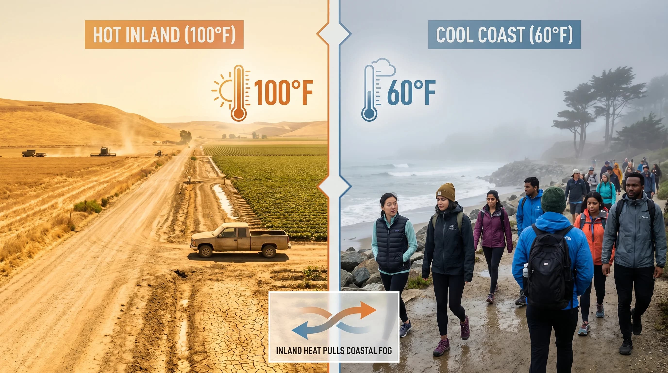
If summer is when you have to visit, the East Bay is your friend. Walnut Creekand the Lamorinda communities sit far enough inland to miss the marine layer on most summer days, running 85 to 90 degrees while San Francisco's west side hovers at 62. Even Oakland, just across the bridge, offers meaningful relief. The bay is only 10 miles wide, but those 10 miles make a substantial difference when the fog machine is running at full power.
The Bottom Line
Bay Area summer fog is intense precisely because Bay Area summers are hot inland. The two facts are not in tension; they are the same mechanism viewed from opposite ends. The hotter the interior, the stronger the marine layer push, the foggier the coast. That inverts the common assumption that fog is a cold-weather phenomenon. In San Francisco, fog is a heat-weather phenomenon, one of the more elegant ironies in American regional climate.