San Francisco's summer fog does not simply appear and disappear at random. Its daily rhythm, when it thickens, when it retreats, and when it burns off entirely, follows a predictable pattern driven by a specific mechanism: the Central Valley thermal low. That pattern is the key to knowing when to be in the city for sunshine, when to head inland for warmth, and why your afternoon plans are almost always more reliable than your morning plans in July.
What Is the Central Valley Thermal Low?
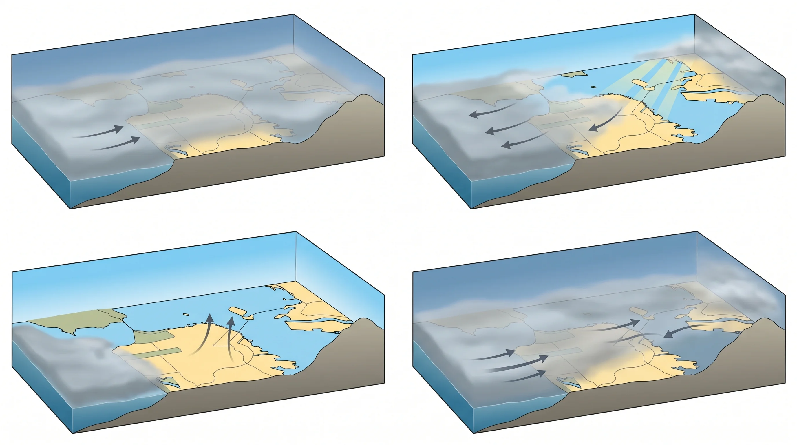
California's Central Valley is a long, flat basin that heats up rapidly on summer days. By afternoon, inland temperatures routinely reach 95 to 105 degrees Fahrenheit in June, July, and August. As the land surface heats, the air above it warms, expands, and rises. Rising air creates lower surface pressure, and the Central Valley develops what meteorologists call a thermal low: a region of low atmospheric pressure created by intense solar heating.
Pressure gradients drive wind. Air moves from higher pressure toward lower pressure, and the thermal low over the Central Valley creates a strong pressure gradient between the cool, dense marine air sitting over the Pacific Ocean and the hot, light air over the interior. This gradient is the engine that pulls marine air, including the fog layer, through the Golden Gate and into the Bay Area every afternoon. The hotter the Central Valley gets, the stronger the pull.
The Daily Fog Cycle in San Francisco
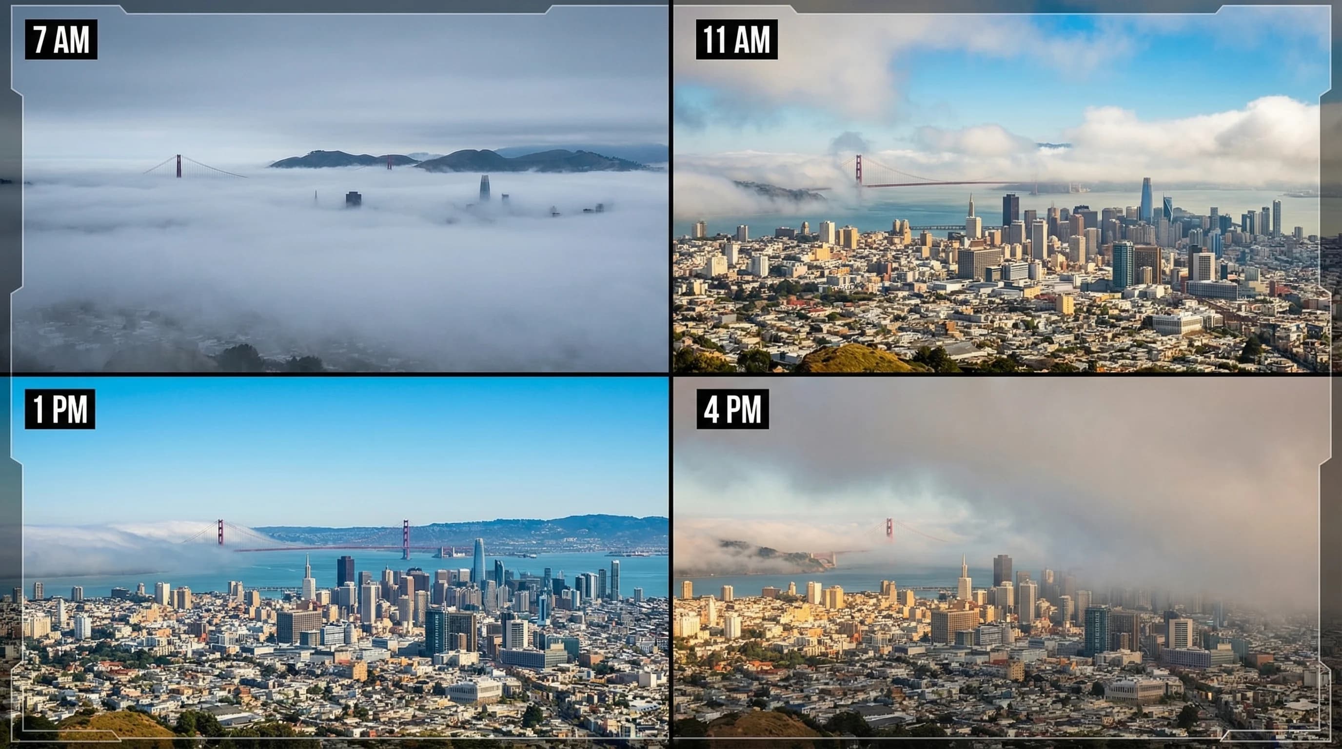
The fog in San Francisco follows a daily pattern that is remarkably consistent from June through August. Fog typically forms or thickens overnight, when the thermal low weakens as the valley cools. By early morning, the marine layer has often pushed deepest into the bay and the city. The Inner Sunset, Outer Sunset, and Richmond neighborhoods are frequently completely fogged in at 7 or 8 a.m., while downtown and the Mission may be partly cloudy.
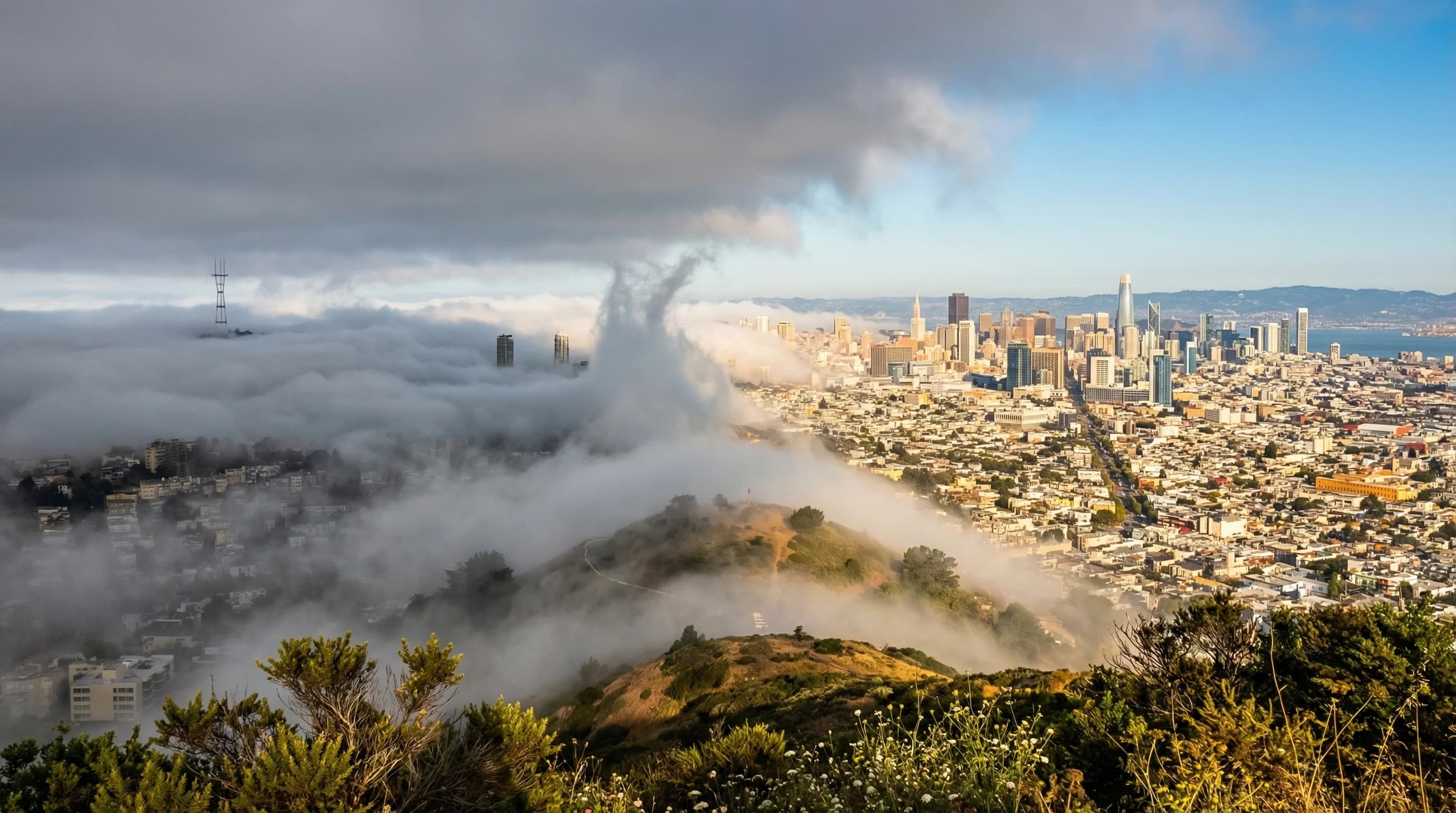
As the morning progresses, two things happen. Solar heating begins to warm the ocean side surface air, slowly eroding the bottom of the fog layer. Simultaneously, the Central Valley reheats from the previous day, strengthening the thermal low. The fog may first clear from higher elevations: Twin Peaks, Noe Valley, and the Castro often break into sunshine while the western neighborhoods remain fogged in.
In many neighborhoods, the fog burns off between 10 a.m. and 1 p.m. The process is visible as a lifting and thinning of the marine layer: the cloud base rises, visibility improves at street level, and patches of blue sky appear. By early afternoon on most summer days, at least the eastern and southern parts of San Francisco are in sunshine. The western neighborhoods, particularly the Outer Sunset and Outer Richmond, may remain under the marine layer through most of the afternoon.
Why the Fog Returns Every Afternoon
Here is the part that frustrates visitors expecting a sunny afternoon to stay sunny: in many neighborhoods, the fog returns. By 3 to 5 p.m., the thermal low reaches its peak strength as the Central Valley hits maximum afternoon heating. The pressure gradient from ocean to interior is at its strongest, pulling a fresh surge of marine air through the Golden Gate. This afternoon fog push is different from the overnight marine layer: it is more wind-driven, accompanied by the famous afternoon westerlies that barrel through the city at 15 to 25 mph.
The result is that many summer days in San Francisco follow a pattern of morning fog, a brief window of sunshine around midday, then increasing clouds and wind in the afternoon as the marine layer re-establishes. The Inner Sunset can go from clear at noon to thick fog by 4 p.m. The Embarcadero may have beautiful afternoon light while the Haight is already gray. The pattern is neighborhood-specific and depends on elevation, position relative to the Golden Gate, and exposure to the prevailing westerly wind.
Fog Burn-Off Varies Dramatically by Neighborhood
The fog does not burn off uniformly across San Francisco. The variation between neighborhoods is one of the defining features of living in the city, and it comes down to elevation and proximity to the Golden Gate.
The western neighborhoods, Outer Sunset, Outer Richmond, and the area around Ocean Beach, sit at low elevation and directly in the path of incoming marine air. They have the latest burn-off and the earliest fog return. It is common for these neighborhoods to have the marine layer all day on a given summer day. The Inner Sunset and Inner Richmond, protected by Buena Vista Park and the Central Freeway rise, burn off a bit earlier.
The Castro, Noe Valley, and the Mission sit on the lee side of Twin Peaks and the Corona Heights ridge, partially shielded from the direct marine air flow. These neighborhoods burn off fastest and are frequently warm and sunny while the western half of the city is still under the ceiling. Neighborhoods at elevation, like Twin Peaks, Bernal Heights, and the upper Haight, often poke above the marine layer into sunshine even when the surrounding area is fogged in at street level.
The Sunset District in summer can be 10 to 15 degrees cooler than the Mission District, which is less than two miles away but sheltered by terrain from the direct marine flow. This is not a random weather quirk. It is a predictable outcome of the neighborhood's elevation and position relative to the Golden Gate corridor.
When Does the Fog Stay Gone All Day?
Full-day sunshine in San Francisco in summer requires one of a few conditions. The North Pacific High needs to weaken enough that the marine layer thins and pulls back. The Central Valley thermal low needs to be moderate rather than extreme, reducing the pressure gradient that draws marine air inland. Or offshore winds need to develop, pushing the marine layer out to sea rather than allowing it to flow inland.
These conditions are more common in September and October than in July and August. By September, the North Pacific High weakens, the Central Valley begins to moderate, and the thermal low is less intense. The result is longer windows of sunshine and less reliable fog return in the afternoon. October is statistically San Francisco's warmest month for daytime high temperatures precisely because the fog machine weakens. The city can reach 70 to 80 degrees on October days that would have been 58 degrees with full fog cover in July.
For the most consistently clear summer days, Oakland and the East Bay offer a reliable alternative. The Berkeley Hills block the direct marine layer flow, and East Bay cities typically burn off by 10 a.m. and stay clear all day, even when San Francisco is still fogged in. On a typical July day when the Outer Sunset is at 58 degrees under marine ceiling, downtown Oakland is at 78 degrees and sunny. The Bay Bridge is literally the boundary between two different weather systems.