The fog that defines San Francisco's summers does not form over the city. It forms over the cold Pacific Ocean, sometimes hundreds of miles offshore, and travels to the Bay Area on the wind. This ocean fog, also called sea fog or marine fog, is the source of the Bay Area's most iconic weather, and understanding how it forms over open water and how it travels to shore explains the daily patterns that San Francisco residents and visitors experience. Ocean fog follows different rules from the radiation fog that forms in valleys or the urban fog that forms over cities. It is an oceanic phenomenon that the Bay Area happens to import every summer.
How Ocean Fog Forms
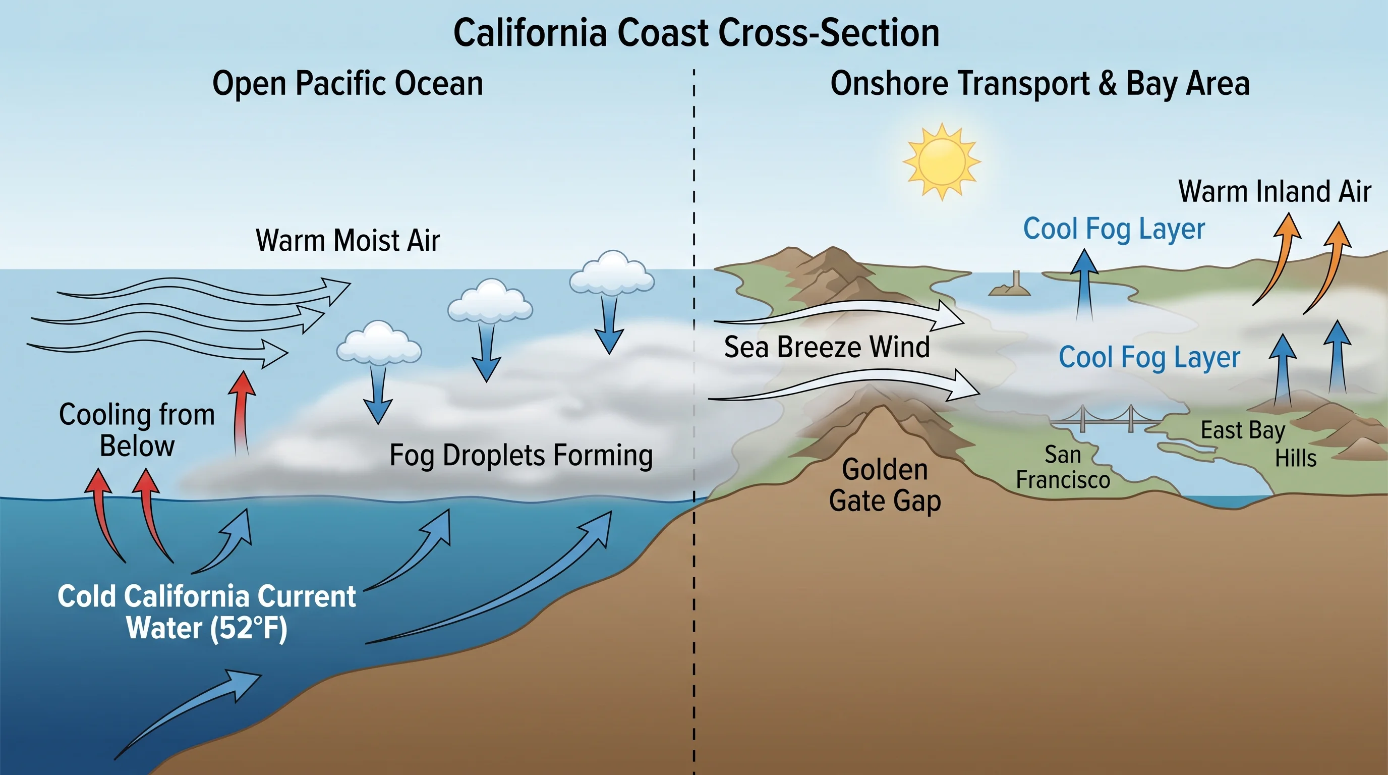
Ocean fog forms when warm, moist air moves over a cold ocean surface and is chilled from below to its dew point. This is advection fog, fog formed by horizontal air movement rather than the radiative cooling that produces inland radiation fog. Along the California coast, the setup is exceptionally favorable for advection fog formation. The California Current brings cold water southward along the Pacific Coast from the Gulf of Alaska, and coastal upwelling driven by northerly winds brings even colder water from depth to the surface. The ocean off San Francisco in July is typically in the low to mid-50s Fahrenheit, far colder than the air mass above it.
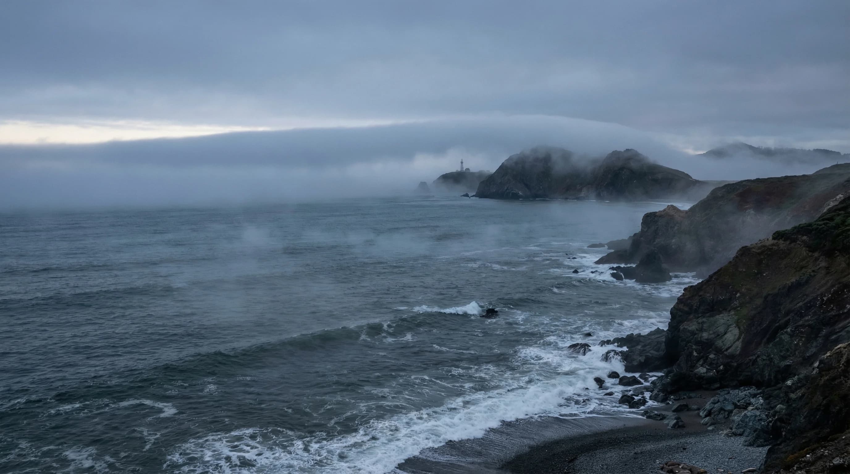
When this cold ocean surface meets the warmer, moisture-laden air moving above it, the air cools to its dew point and fog forms. The fog layer that results can extend from the ocean surface up to 1,000 to 1,500 feet, thick enough to block sunlight completely and dense enough to reduce visibility to near zero. This is not a thin haze but a substantial cloud formation that happens to be located at sea level.
From Ocean to Shore: Fog Transport
Once formed over the ocean, sea fog travels with the wind. Along the California coast, the dominant summer wind is northwesterly, blowing roughly from northwest to southeast parallel to the coast, but with a component that pushes the fog toward shore. The fog moves as a coherent mass, maintaining its structure as it travels over the water. When it reaches land, it encounters the heated terrain of the California coast and two things can happen: it can be lifted and dissipate as the warm land heats the fog's base, or it can flow onshore and inland if a gap in the terrain allows it to penetrate.
The Golden Gate is the Bay Area's primary fog penetration point. The gap in the Coast Ranges at the strait allows the offshore fog to flow directly into the Bay without having to climb over terrain. Once through the Gate, the fog spreads across the Bay and is carried inland by the pressure gradient between the cool coast and the heated Central Valley interior. The marine layer that reaches Oakland and eventually the East Bay foothills began as ocean fog off the California coast earlier in the same day.
Why Northern California Sea Fog Is So Thick
Sea fog occurs along many cold-current coastlines around the world: the Labrador Coast of Canada, the Benguela Current coast of Namibia and South Africa, the Humboldt Current coast of Chile and Peru. But the California coast produces particularly persistent and thick sea fog because of the specific combination of factors that operate here: a strong, year-round cold current, intense summer coastal upwelling, a continental heating engine (the Central Valley) that creates a strong pressure gradient drawing fog onshore, and a gap in the coastal mountains (the Golden Gate) that allows fog to penetrate far inland rather than being blocked at the shoreline.
The marine layer that results from this combination can be 500 to 1,500 feet deep, thick enough to feel like a complete overcast, not a thin coastal haze. The fog deck in July over the California coast is a genuine feature visible from satellite, showing the Bay Area enveloped in a solid white layer while the Central Valley and the Sierra Nevada sit in sunshine. From above, it looks exactly like what it is: an ocean cloud that has drifted over the land.
The sea fog's behavior follows the ocean temperature. In years when El Nino warms the California Current, the ocean is slightly warmer, the fog formation mechanism is weaker, and the Bay Area experiences somewhat less fog. In La Nina years, when the California Current runs colder, fog formation intensifies. This connection between tropical Pacific temperatures and Bay Area fog is one of the clearer El Nino signals in California's regional climate, a reminder that the fog San Francisco residents navigate every summer morning is not a local phenomenon but a thread in a Pacific-wide pattern of ocean and atmosphere.