
Santa Cruz sits at the northern end of Monterey Bay, sheltered from the direct Pacific swell by Point Año Nuevo to the north and the curve of the bay to the south. This geography gives it something genuinely unusual for a Northern California coastal town: measurably warmer summer temperatures and more reliable sunshine than the Bay Area coastline to its north. While Half Moon Bay shivers at 60 degrees and San Francisco sits under its marine layer, Santa Cruz often clears to the low to mid-70s on summer afternoons, warm enough for beach weather by any standard. It is the closest thing the Bay Area has to a traditional California beach town, and its weather is the reason.
Why Santa Cruz Is Warmer Than the Bay Area Coast
The Santa Cruz Mountains provide partial shelter from the dominant northwest marine flow. The coastal strip from Davenport south through Santa Cruz sits partially in the lee of the mountains' southern end, which deflects some of the cold onshore wind that hammers the exposed coastline north of the Bay. Additionally, Monterey Bay's orientation means that the coldest water upwelling, driven by northwest winds along the exposed outer coast, is less intense in the sheltered inner bay near Santa Cruz than it is along the San Mateo County coast.
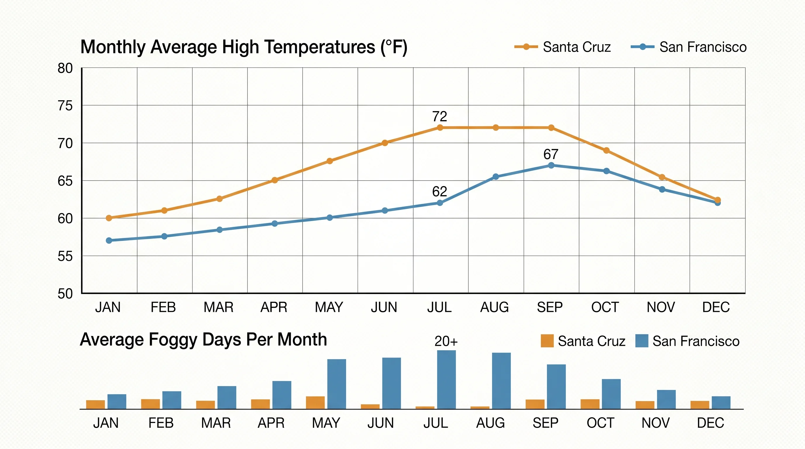
The result is sea surface temperatures near Santa Cruz that typically run a few degrees warmer than those at Half Moon Bay, and air temperatures that are correspondingly warmer. The ocean is still cold by most standards. Summer water temperatures near Santa Cruz run in the high 50s to low 60s Fahrenheit, cold enough to require a wetsuit for any extended swimming. But the difference between "wetsuit required" and "you will have hypothermia in 20 minutes" is significant, and it shows in the beach culture Santa Cruz has developed.
Summer: The Best Season
Santa Cruz summers are the highlight of the regional weather calendar. July and August average highs run around 70 to 74 degrees Fahrenheit, with occasional warmer days when offshore flow conditions push temperatures into the low 80s. Morning fog is common. Santa Cruz is not immune to the marine layer, but the fog typically burns off earlier than it does in San Francisco, clearing by 10 or 11am on most days to reveal blue skies and gentle afternoon sea breezes.
The beach on West Cliff Drive and the main beach near the Boardwalk fill with locals and Bay Area visitors every summer weekend. The difference in beach weather between Santa Cruz and San Francisco, just 75 miles north, explains the traffic on Highway 17 every Friday afternoon from June through September. For Bay Area residents seeking genuine beach weather without driving to Southern California, Santa Cruz is the closest practical option.
Fall and the Offshore Flow Window
September and October bring Santa Cruz's warmest and most reliably clear days. The Indian summer pattern that warms the entire Bay Area is particularly effective here: when offshore flow replaces the onshore marine push, Santa Cruz can reach the mid-80s Fahrenheit, genuinely warm by Northern California standards. These are the days when the Boardwalk and beaches are at their most pleasant, and the tourist crowd thins enough that the experience is less congested than the peak summer weeks.
The ocean swells of fall also bring the best surfing conditions of the year to Santa Cruz. The combination of northwest and west swells generated by Pacific storms combines with the town's variety of breaks, including Steamer Lane at West Cliff Drive, among the most famous surf spots in Northern California, to produce excellent surfing conditions in September through November. The water is warmer in early fall than at any other time of year (having absorbed summer heat), making the fall surf season the most comfortable for those without the full cold-water gear required in winter and spring.
Winter: Mild but Wet
Santa Cruz winters are mild, with daytime highs typically in the low to mid-60s Fahrenheit, but the storm season brings rain and surf. The city sits exposed to the west, and winter swells from Pacific storms generate significant surf at Steamer Lane and other breaks. Flooding can occur in the low-lying San Lorenzo River corridor near downtown Santa Cruz during intense atmospheric river events. The surrounding Santa Cruz Mountains, rising steeply behind the city, receive substantial orographic rainfall and occasional snow at higher elevations.
For visitors, winter in Santa Cruz means uncrowded beaches, dramatic storm surf, and the kind of moody coastal atmosphere that the Pacific Coast Highway is famous for. The redwood forests in the mountains behind the city, Henry Cowell Redwoods and Big Basin, are at their wettest and most primeval in winter, the streams running full and the forest floor vivid green. Santa Cruz is worth visiting in any season, but each season requires a different set of expectations, different footwear, and a different understanding of what the Pacific coast offers when the sun is not shining.