May is when the Bay Area starts to feel like someone turned on the fan. A morning can begin calm and bright, then by afternoon the flags are snapping, the bay is covered in whitecaps, and the west side of San Francisco feels 15 degrees colder than the thermometer suggests. That pattern is not a random spring quirk. It is the warm-season pressure engine coming online: the North Pacific High offshore, inland California heating up, and cool marine air being pulled through the Bay Area's gaps and corridors.
The same setup explains much of the region's summer weather: the marine layer, coastal fog, cold ocean water, and the dependable afternoon winds that shape sailing, kiteboarding, hiking, and daily life near the bay. May matters because it is the transition month. Winter storms are mostly gone, the dry season is taking hold, and the atmosphere starts behaving like summer even before the calendar says so.
Why May Feels Windy in the Bay Area
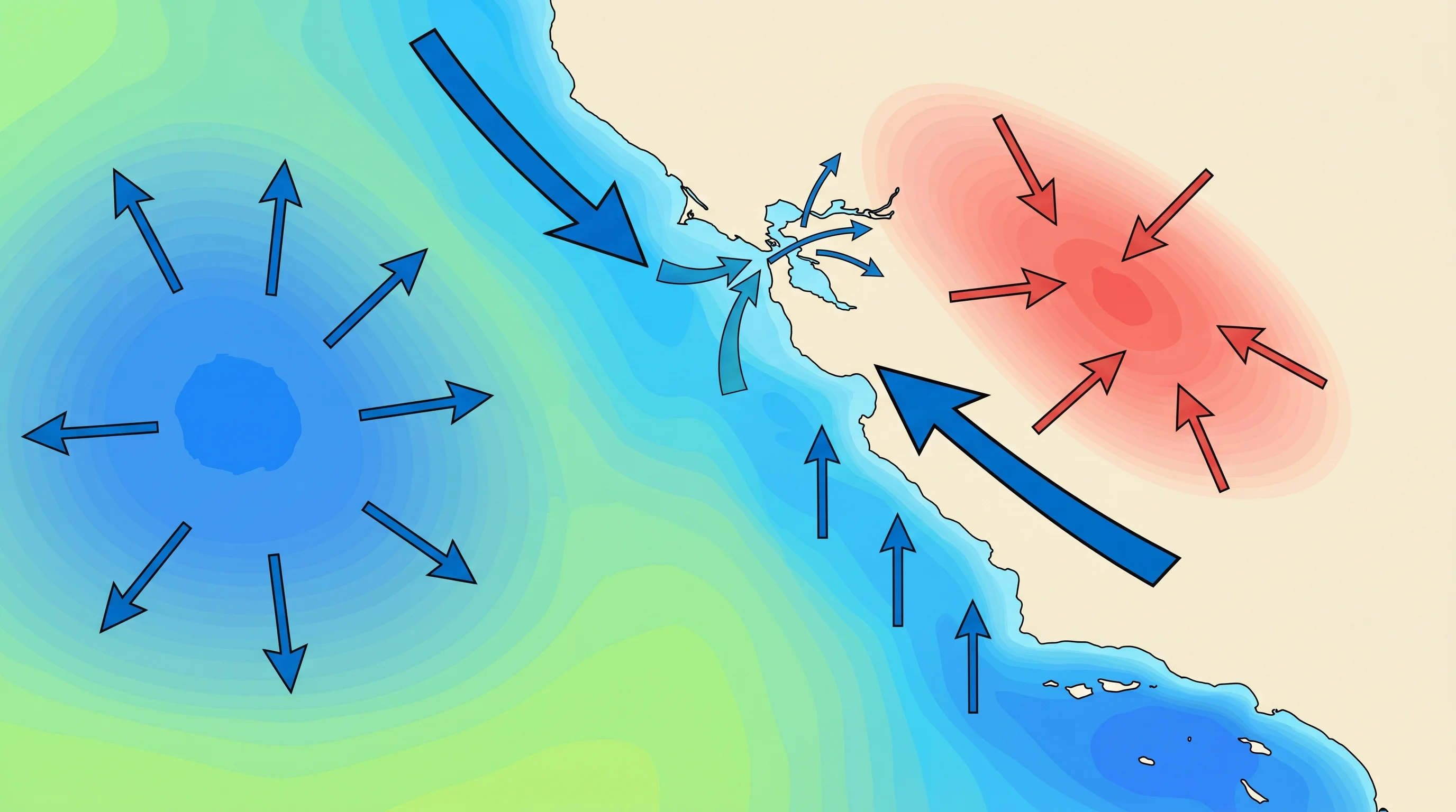
The Bay Area gets windy in May because the temperature contrast between the cold Pacific and the warming interior strengthens quickly. The ocean changes temperature slowly and remains in the low-to-mid 50s, while the Central Valley and inland East Bay can jump into the 80s and 90s during spring warm spells. Warm inland air rises and lowers surface pressure. Cool, dense marine air sits offshore and along the coast under higher pressure. Air moves from high pressure toward low pressure, so the Bay Area becomes the pathway.
This is the same physics behind the broader Bay Area wind pattern, but May is when it becomes consistent enough that people notice it day after day. The morning can still be gentle because inland heating has not peaked. By early or mid-afternoon, the inland thermal low deepens, the pressure gradient tightens, and the onshore wind accelerates through the Golden Gate and across the bay.
What the North Pacific High Does
The North Pacific High is a large, semi-permanent high-pressure system over the eastern Pacific. It is not a single storm or a one-day weather feature. It is a seasonal atmospheric pattern that expands and shifts as the West Coast moves from winter into spring and summer. In winter, the storm track can dip into California and bring rain. In late spring, the high becomes more dominant, helping block storms and favoring persistent northwest flow along the coast.
That northwest flow matters. Along the California coast, winds blowing from northwest to southeast run roughly parallel to the shoreline. Because of the Coriolis effect, surface water is pushed offshore, allowing cold deep water to rise in its place. That process, called upwelling, is central to Bay Area fog and cold ocean temperatures. The high does not just make the air windy; it helps maintain the cold ocean surface that makes the marine layer possible.
Why May Is the Ramp-Up Month
May sits between two regimes. Winter's storm pattern has usually weakened, but the peak July and August marine layer has not fully settled in. That makes May variable: some days are calm and warm, while others turn sharply windy by afternoon. The underlying trend, though, is toward more frequent northwest winds, stronger afternoon sea breezes, and more reliable marine air pushes.
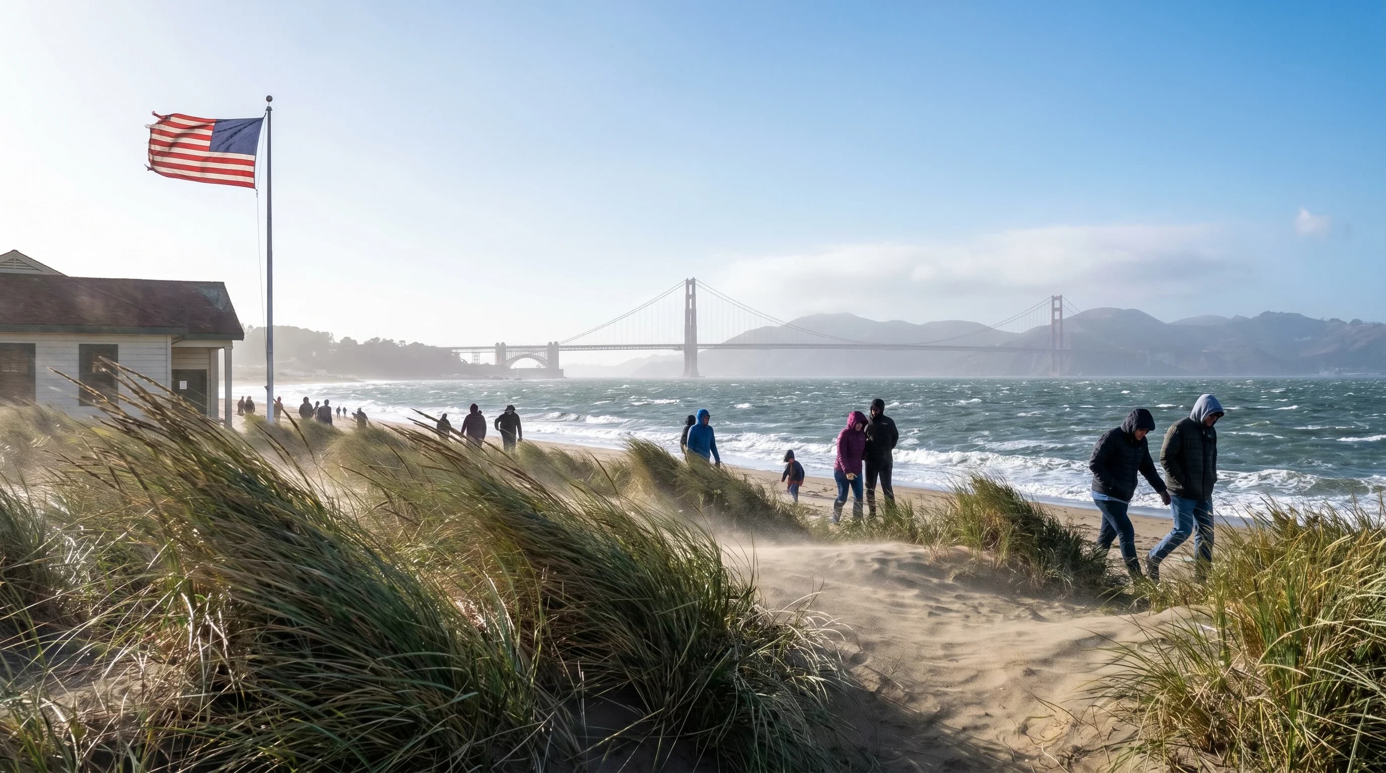
The timing is important for visitors. May is often marketed as a pleasant spring month, and it can be. Inland destinations such as Walnut Creek, Livermore, and the South Bay may feel warm and bright. But exposed coastal and bay-shore locations can feel cold once the wind arrives. A sunny 61-degree afternoon at Ocean Beach, Crissy Field, or the Marin Headlands can feel much colder because wind strips heat from skin and clothing.
How the Wind Reaches the Bay Area
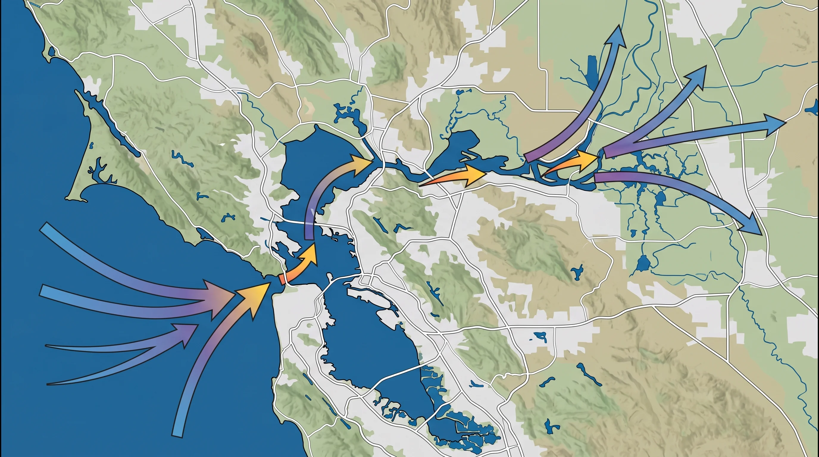
The Bay Area does not receive the regional wind evenly. Geography focuses it. The Golden Gate is the most important gap, pulling Pacific air directly into San Francisco Bay. That is why Crissy Field, the Golden Gate Bridge, Alcatraz, and the northern waterfront can be dramatically windier than sheltered neighborhoods just a few miles away. The bay itself then gives the air a low-friction path inland.
Farther east, the flow continues through other corridors. The Carquinez Strait channels air toward the Delta, while Altamont Pass accelerates wind between the Livermore Valley and the Central Valley. These corridors are why Bay Area wind can feel highly localized. A neighborhood tucked behind a hill can be comfortable while a nearby ridge, marina, bridge, or pass is blowing hard.
Why Wind, Fog, and Cold Water Arrive Together
Wind, fog, and cold coastal water are different expressions of the same seasonal setup. The North Pacific High encourages northwest coastal winds. Those winds strengthen upwelling, which chills the ocean surface. Cold ocean water cools the air above it, helping create the marine layer. Inland heating then pulls that cool marine air and, on foggy days, low cloud through the Bay Area's gaps.
This is why May can feel contradictory. You can see clear spring sunshine, but the air arriving from the ocean has been chilled over cold water and accelerated by the pressure gradient. That combination makes the region feel windier and colder than the raw air temperature suggests. For the detailed daily version of this pattern, the Bay Area sea breeze article breaks down how the afternoon cycle works.
Where the May Wind Is Most Noticeable
The strongest spring wind signals show up in exposed places first: Ocean Beach, the Golden Gate, the Marin Headlands, Treasure Island, the Berkeley waterfront, the San Mateo coast, and the Altamont corridor. At the Berkeley Marina, the afternoon wind can arrive like a schedule. The same pattern makes spring and summer reliable for sailing and kiteboarding, but it can catch hikers and beach visitors off guard.
Wind also changes the comfort math. A 58-degree May afternoon with a 25 mph wind can feel closer to the upper 40s on exposed skin. That is why the practical advice is simple: bring a windproof layer, especially if your plan includes the coast, the bay shore, a bridge, or an exposed ridge. For more on how wind changes the felt temperature, see the Bay Area wind chill guide.
How to Plan Around Spring Wind
The most useful rule is to plan outdoor activities with the daily wind cycle in mind. Mornings are usually calmer. Afternoons are usually windier. If you want a calmer walk across the Golden Gate Bridge, a less gusty beach visit, or easier conditions on an exposed hike, start early. If you are sailing, kiteboarding, or windsurfing, the afternoon is often the point.
May wind is not a sign that the weather is broken. It is the Bay Area's warm-season climate engine starting up. The North Pacific High, inland heating, upwelling, marine air, fog, and local terrain all connect. Once you understand that chain, the region's spring weather becomes more predictable: warm inland, cold near the water, calmest in the morning, and windier almost every afternoon.