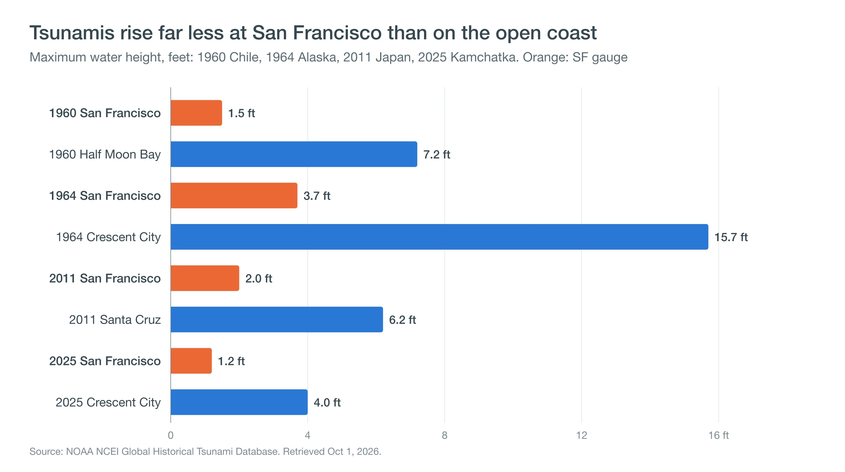
Yes, a tsunami can reach San Francisco, and several have: the 1964 Alaska tsunami raised the water about 3.7 feet at the city's tide gauge, and the 2011 Japan tsunami about 2 feet. The biggest risk is a distant Alaska earthquake, which would give the Bay Area about five hours of warning.
The same 1964 tsunami hit Crescent City at 4.8 meters (about 16 feet) and killed 10 people there, according to NOAA's tsunami database. That gap is the real story: the Golden Gate shields the city better than most people fear, while the open coast and harbors take the damage.
Can a Tsunami Hit San Francisco?
A tsunami can hit San Francisco, but the record shows small rises at the city's gauge. The danger is less a towering wave than strong currents and flooding in low areas, and it is worst in harbors and on the open coast outside the Golden Gate.
| Tsunami | San Francisco gauge | Hardest-hit nearby coast |
|---|---|---|
| 1960 Chile | 0.46 m (1.5 ft) | Half Moon Bay area 2.2 m (7.2 ft) |
| 1964 Alaska | 1.13 m (3.7 ft) | Crescent City 4.8 m (15.7 ft), 10 deaths |
| 2011 Japan | 0.62 m (2.0 ft) | Santa Cruz Harbor 1.9 m (6.2 ft), about $28 million damage |
| 2022 Tonga | 0.33 m (1.1 ft) | Santa Cruz Harbor, about $6.5 million damage |
| 2025 Kamchatka | 0.37 m (1.2 ft) | Crescent City 1.21 m (4.0 ft) |
Maximum recorded water heights from the NOAA NCEI Global Historical Tsunami Database, retrieved October 1, 2026. Heights are the rise in water level above the normal tide, not the height of a breaking wave.
Has a Tsunami Ever Hit San Francisco?
Tsunamis have reached San Francisco many times, and five modern ones stand out in NOAA's records for the city's gauge: 1960 (Chile), 1964 (Alaska), 2011 (Japan), 2022 (Tonga) and 2025 (Kamchatka). The largest, in 1964, raised the water 1.13 meters (3.7 feet). The others ranged from about 1.1 to 2 feet.
Tsunami heights describe the water rising above the normal tide, often as a fast surge that floods and drains like a tide on fast-forward. Even small surges cause damage inside the bay: in 1964 the water rose about 4 feet at Oakland and Sausalito reported damage, and in 2011 surges damaged docks at the Berkeley Marina and Waldo Point Marina in Sausalito.
Why Does the Golden Gate Protect the Bay, and Where Is the Risk Higher?
The Golden Gate protects the bay because its narrow opening limits how much tsunami energy can flow in. The open coast faces the surge directly, so Ocean Beach, Pacifica and Half Moon Bay see bigger effects than the city's bayside gauge.
Enclosed harbors are the hot spots, because surges slosh back and forth inside them and build strong currents. Santa Cruz Harbor took about $28 million in damage in 2011, and Crescent City, on the far North Coast, was badly damaged in both 1964 and 2011. If you live near the coast south of the city, see Half Moon Bay weather and Santa Cruz weather.
Which Parts of San Francisco Are in a Tsunami Hazard Area?
San Francisco's tsunami hazard areas are along its low-lying shoreline. They include Ocean Beach and the Great Highway, the zoo grounds, the Marina, the Embarcadero, North Beach, downtown near Market Street and Mission Bay.
The California Geological Survey's 2021 maps use a magnitude 9.3 eastern Aleutian earthquake as the worst case, a thousand-year scenario meant for evacuation planning. Look up your address on the CGS tsunami hazard maps, and compare with other shoreline risks on the Bay Area flood maps.
How Much Warning Would the Bay Area Get?
The Bay Area would get hours of warning from a distant earthquake. In the state's worst-case Alaska scenario, the first surges reach the Bay Area in about five hours, and a tsunami from Japan or South America takes longer still.
A nearby earthquake gives far less time. A large quake on the Cascadia subduction zone or offshore Northern California could send surges to the coast much sooner. If you feel strong shaking at the coast, move to high ground right away without waiting for an alert.
What Do Tsunami Warnings, Advisories and Watches Mean?
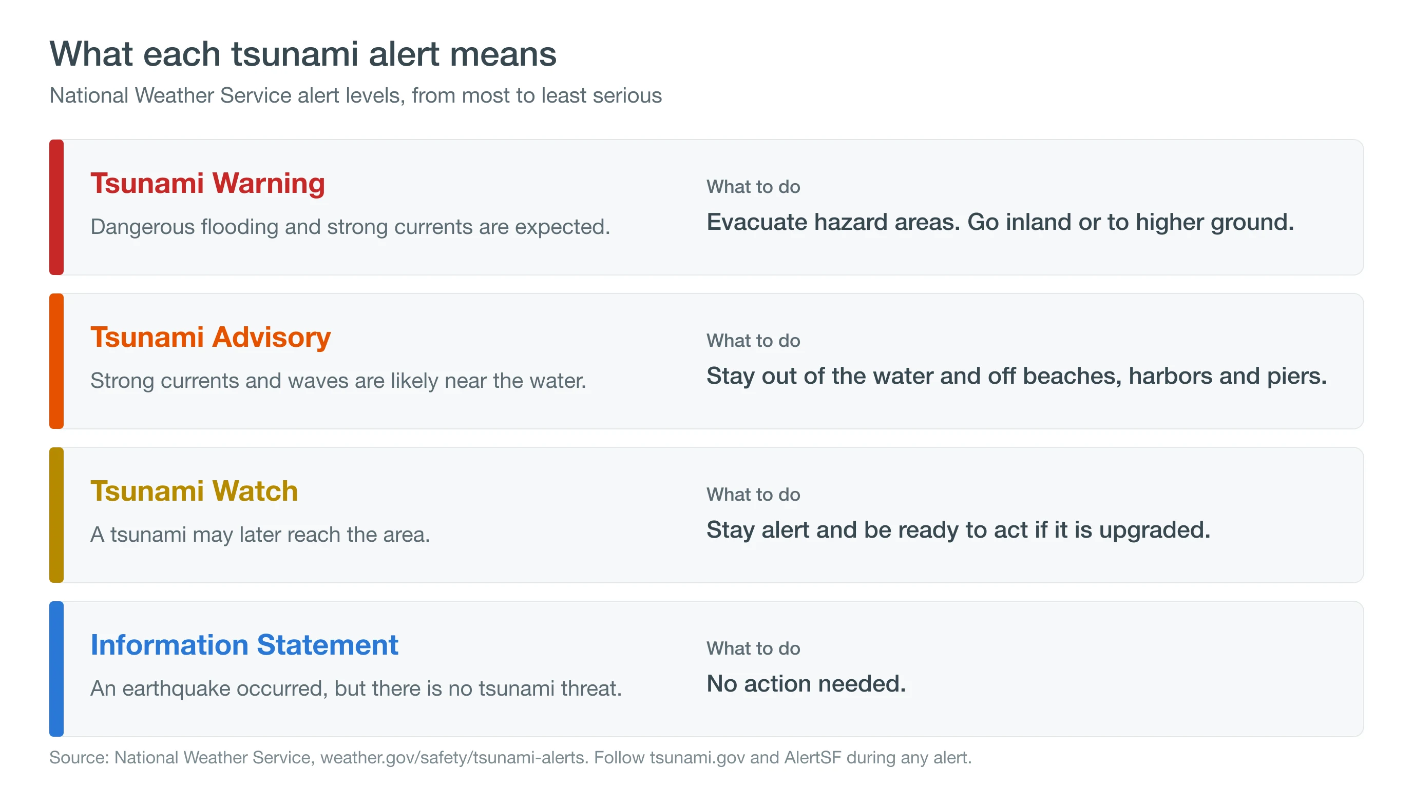
A Tsunami Warning means dangerous flooding is expected, so evacuate hazard areas. A Tsunami Advisory means strong currents are likely, so stay out of the water and off beaches and piers. A Tsunami Watch means a tsunami may occur, so get ready, and an Information Statement means there is no threat.
The Bay Area saw a warning on December 5, 2024, when a magnitude 7.0 earthquake off Cape Mendocino at 10:44 AM prompted a Tsunami Warning for about 500 miles of coast, from Davenport into Oregon. The National Weather Service canceled it at 11:54 AM, and the tsunami never topped about 4 inches at any sea-level station. For how other coastal alerts work, see coastal flood advisories and warnings.
How Does San Francisco Warn People, and What Should You Do?
San Francisco warns people through AlertSF text messages, Wireless Emergency Alerts on phones, emergency vehicles with loudspeakers in evacuation zones, and radio and TV. Sign up for AlertSF at AlertSF.org or by texting your ZIP code to 888-777.
In a warning, leave beaches, harbors and low areas and go inland or to higher ground. Stay away until officials give the all-clear, because surges can continue for hours. Tsunamis are rare, but the coast has more frequent dangers too: read about sneaker waves and king tides.
Look up your home and workplace on the CGS tsunami hazard maps and sign up for AlertSF. During any alert, follow the National Tsunami Warning Center at tsunami.gov rather than social media.