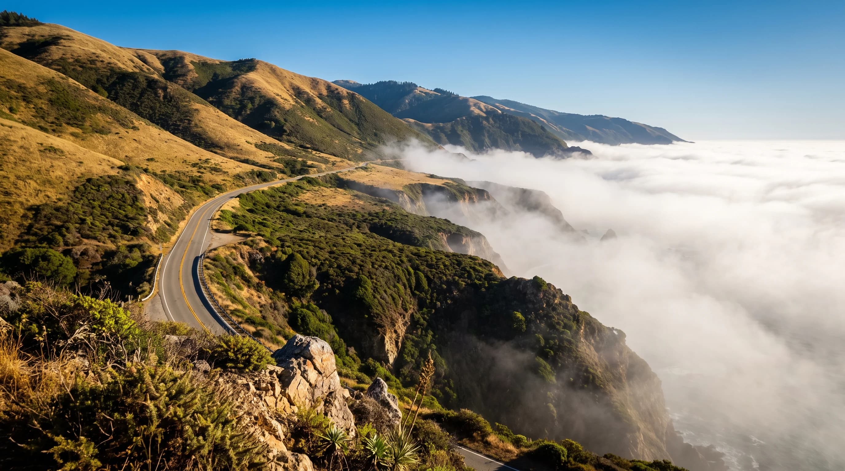
Big Sur is mild all year but splits into seasons: foggy summers on the coast, warm and clear Septembers and Octobers, and wet winters with about 44 inches of rain a year at Big Sur Station. The best time to visit is September through early November, and April through May for wildflowers and waterfalls.
Big Sur Station gets more than twice the rain of Monterey, 25 miles north, and in the 1982-83 El Niño winter it recorded 86.5 inches. Those storms are why Highway 1 keeps falling into the sea, so the weather decides not just what you pack but whether you can drive there.
What Is the Weather Like in Big Sur?
Big Sur's weather is really three climates: a foggy coastline, sunny ridges above the marine layer, and warm, sheltered valleys. The table below comes from NOAA's Big Sur Station, in the Big Sur River valley at Pfeiffer Big Sur State Park, 200 feet above sea level. The cliffs along Highway 1 run cooler in summer.
| Month | Avg high | Avg low | Rain | What to expect |
|---|---|---|---|---|
| January | 61°F | 42°F | 9.48 in | Wettest stretch; storms can close roads |
| February | 61°F | 43°F | 8.59 in | Storms; full waterfalls between them |
| March | 64°F | 43°F | 6.72 in | Showers, green hills |
| April | 67°F | 44°F | 2.94 in | Wildflowers; mostly dry |
| May | 71°F | 46°F | 1.15 in | Fog returns to the coast |
| June | 74°F | 48°F | 0.20 in | Coastal fog, sunny ridges |
| July | 75°F | 51°F | 0.06 in | Peak fog on the coast |
| August | 77°F | 50°F | 0.05 in | Fog with sunny inland valleys |
| September | 77°F | 50°F | 0.13 in | Warm, often clear; good views |
| October | 74°F | 49°F | 1.88 in | Warm and clear; first rains late |
| November | 65°F | 45°F | 4.16 in | Storm season begins |
| December | 59°F | 43°F | 9.18 in | Wet, quiet, storm watching |
NOAA 1991-2020 normals for Big Sur Station (cooperative station 040790, Pfeiffer Big Sur State Park, 200 ft), via RCC-ACIS. The foggy coastline is cooler than the valley in summer.
Why Is Big Sur's Coast Foggy While the Ridges Stay Sunny?
Big Sur's coast is foggy in summer because the marine layer is shallow. It is usually a few hundred to about 2,000 feet deep, so it wraps the cliffs and Highway 1 while the ridges above climb into sunshine. Drive up a road like Nacimiento-Fergusson and you can often break out above the fog into a clear blue sky.
The same layer can lift by afternoon or sit on the coast all day. For how it forms and moves, read what is the marine layer.
Why Is the Big Sur River Valley So Warm in Summer?
The Big Sur River valley is warm in summer because the mountains shelter it from the cool sea breeze. Big Sur Station averages a high of 77.4°F in August, about 9 degrees warmer than the coast at Monterey (68.7°F), and its record is 111°F, set on September 7, 2020. Campers at Pfeiffer Big Sur get warm afternoons and cool nights near 50°F.
The same mountains that shelter the valley wring rain out of winter storms.
How Much Rain Does Big Sur Get in Winter?
Big Sur Station averages about 44.5 inches of rain a year, more than twice Monterey's 20.4 inches, and nearly all of it falls from November through March. December and January each average more than 9 inches. The Santa Lucia Mountains rise straight from the sea and lift incoming storms, which squeezes out extra rain; see how mountains make more rain.
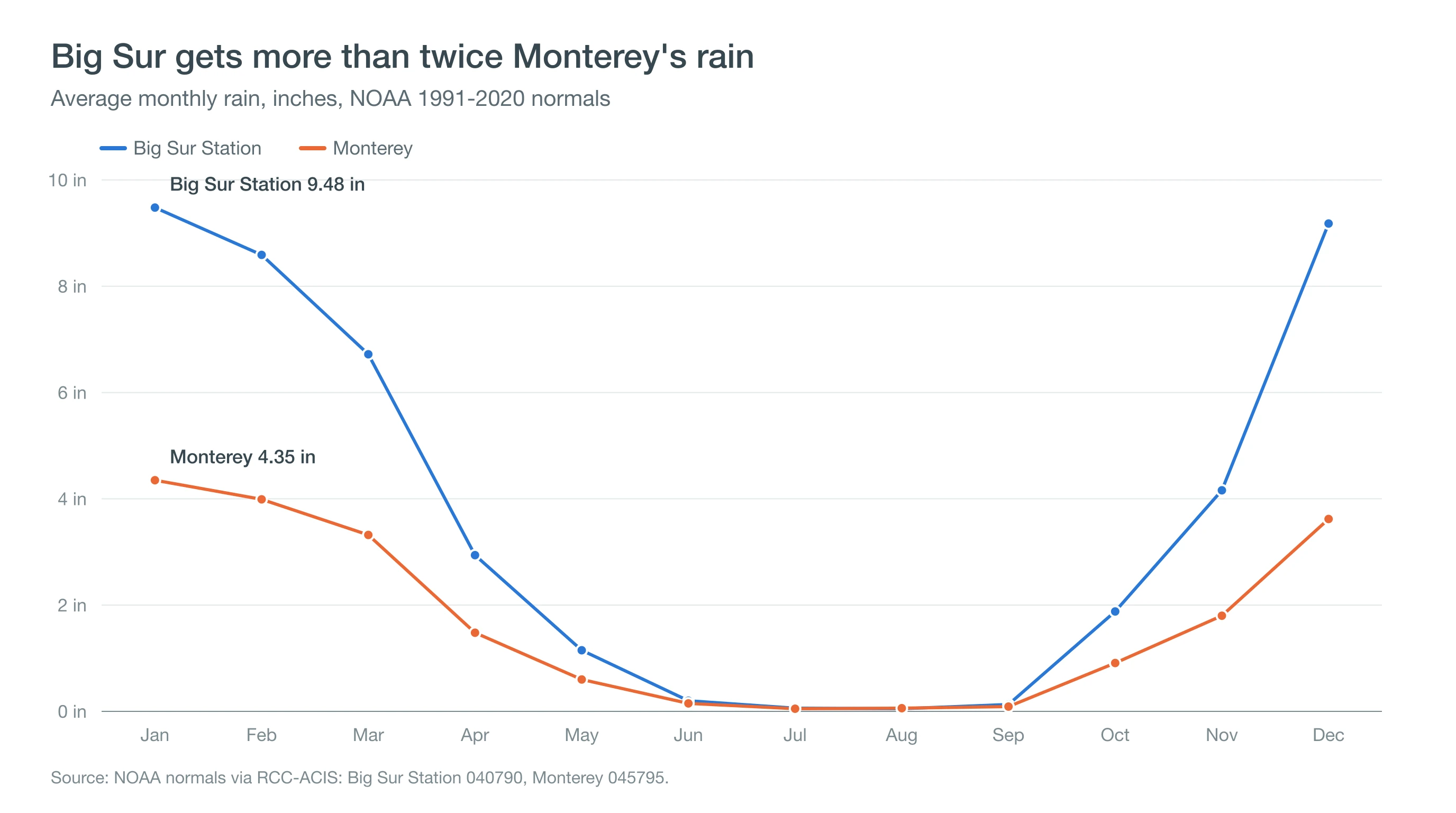
Big Sur's rain swings widely from year to year. The wettest water year on record brought 86.50 inches in 1982-83, followed by 78.96 inches in 1997-98, both strong El Niño winters, while 1976-77 brought just 14.72 inches. Single storms can be huge: 9.23 inches fell on January 31, 1963, and 7.76 inches on January 28, 2021. Read about atmospheric rivers and the El Niño outlook.
Why Does Highway 1 Keep Closing?
Highway 1 keeps closing because heavy rain soaks Big Sur's steep, unstable slopes until they slide onto or out from under the road. The Mud Creek slide buried the highway from May 20, 2017 to July 18, 2018. Paul's Slide closed it from January 14, 2023 to June 23, 2024, and Regent's Slide closed it from February 9, 2024 until January 14, 2026, when Caltrans reopened the full route between Carmel and Cambria.
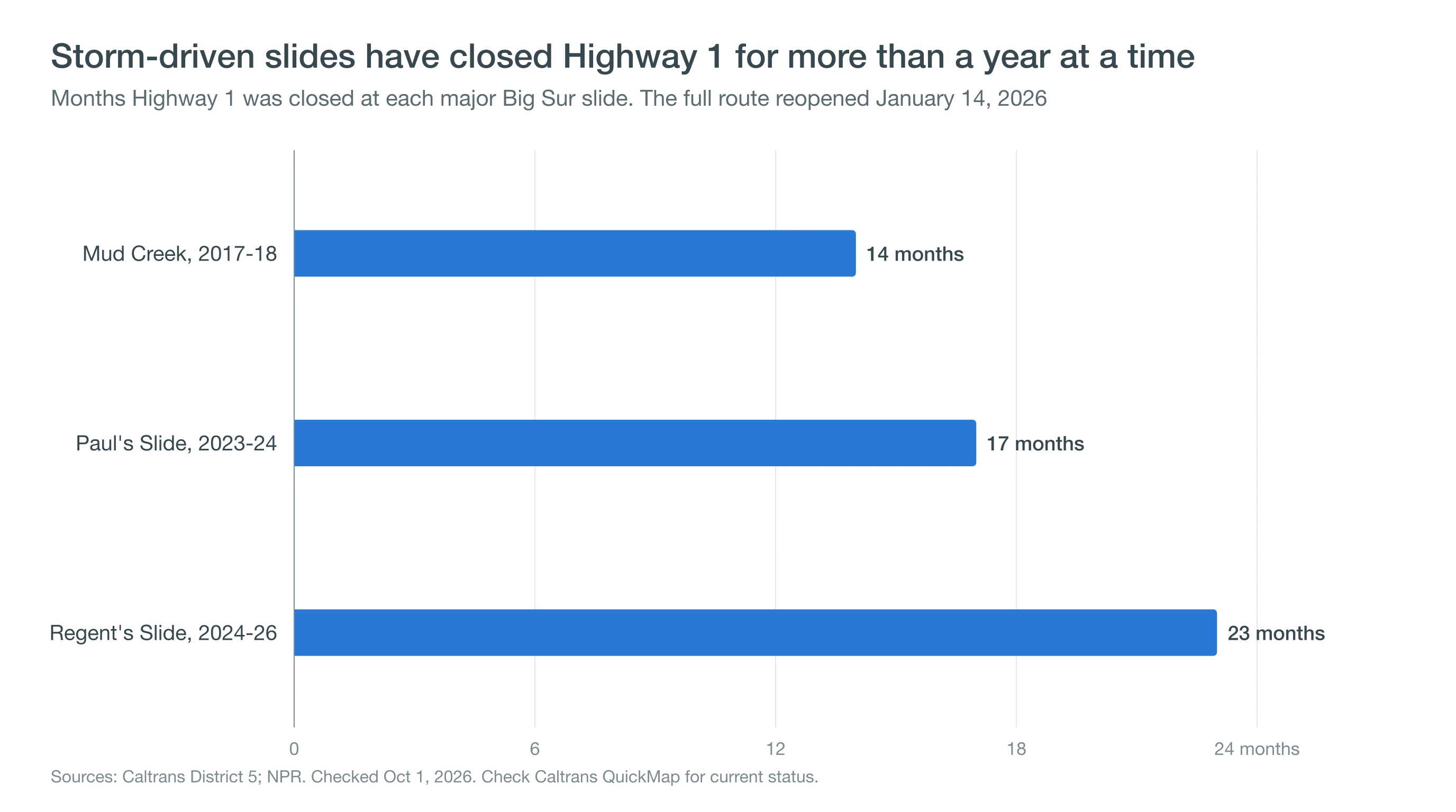
Caltrans still warns of occasional full closures after storms, and road status changes quickly. Always check Caltrans QuickMap before you go rather than relying on any article, including this one.
Is It Safe to Drive Highway 1 Through Big Sur in Winter?
Driving Highway 1 through Big Sur in winter is usually safe on dry days, but storms raise the risk of rockfall, mud and sudden closures. Avoid driving during or right after heavy rain, expect one-way traffic control at work zones, and check QuickMap and CHP traffic incidents before leaving.
Cell coverage is limited along much of the coast, so carry water, snacks and a full tank. Pullouts on the cliffs also face winter swells; stay well back from the water on big-surf days and read about sneaker waves.
What Is the Best Time to Visit Big Sur?
The best time to visit Big Sur is September through early November, when the fog eases, views open up and afternoons are warm. April and May bring wildflowers and waterfalls still running from winter rain. Summer gives long days if you plan time on the ridges or in the valleys above the fog, and winter offers solitude with storm and closure risk.
Pairing Big Sur with the coast to the north? See Carmel-by-the-Sea weather and Monterey weather.
Before you go, check Caltrans QuickMap for Highway 1 status and the National Weather Service Bay Area forecast for storms or Beach Hazards Statements. For the nearest SFBayWeather forecast, use the Carmel-by-the-Sea page.