seasonalsafetyclimate science

The 2020 Bay Area Heat Dome: Record-Breaking August Temperatures

By SFBayWeather||Updated |6 min read
The 2020 Bay Area Heat Dome: Record-Breaking August Temperatures

Key Takeaways

  • The August 2020 heat dome suppressed the marine layer for multiple days, producing all-time records across the Bay Area: Concord 116°F, Livermore 115°F, San Jose 105°F, Santa Rosa 111°F.
  • The heat dome created the conditions for the Lightning Siege: more than 10,000 lightning strikes in 72 hours, igniting 560 simultaneous fires across Northern California.
  • Three fires, the SCU, LNU, and CZU Lightning Complexes, became massive events burning over 800,000 combined acres and forcing evacuation of hundreds of thousands of Bay Area residents.
  • Wildfire smoke turned Bay Area skies orange on September 9, 2020, producing surreal daytime darkness and the worst air quality in the region's recorded history.
  • The 2020 event is now a reference case for compound extreme events: multiple climate stresses (heat, fire, smoke, grid failure) occurring simultaneously, producing outcomes worse than any single stressor.

The third week of August 2020 broke temperature records across California that had stood for decades, triggered the largest mass ignition of wildfires in California history, and produced environmental conditions that much of the state had never experienced and had no infrastructure to handle. The 2020 heat dome was not just an extreme weather event; it was a simultaneous assault on multiple critical systems. While temperatures soared, the sky filled with smoke from 560 simultaneous fires. While the power grid strained under unprecedented cooling demand, rolling blackouts cut power to homes and businesses across the Bay Area. The event became a template for what climate scientists and emergency managers fear the region will face with increasing frequency.

The Meteorology of the 2020 Heat Dome

The August 2020 heat dome developed when a high-pressure ridge built over the Great Basin and extended westward over California. The ridge was exceptionally strong and stationary, which meant the normal mechanism that breaks heat waves, the passage of a trough of low pressure pushing through from the north, was delayed for an extended period. The marine layer, which normally cools the Bay Area's coast every summer afternoon, was suppressed or pushed far offshore. Without the sea breeze and marine layer, temperatures built day after day with minimal overnight recovery.

The heat was remarkable even for California. Concord reached 116 degrees. Livermore recorded 115 degrees. San Jose hit 105. Santa Rosa recorded 111 degrees. Even San Francisco, which had only exceeded 100 degrees a handful of times in recorded history, reached into the mid-90s and above. Death Valley, California, broke the world record for reliably measured temperature, reaching 130 degrees on August 16.

Bay Area night sky orange from wildfire smoke during the August 2020 Lightning Siege, smoke column visible in the distance, eerie orange light over Bay Area communities
The August 2020 heat dome triggered the Lightning Siege: 560 simultaneous fires ignited by dry lightning across Northern California. The smoke from the SCU, LNU, and CZU Lightning Complexes turned Bay Area skies orange and produced some of the worst air quality in the region's history.

The Lightning Siege

The heat dome created the conditions that made the Lightning Siege possible. As the high pressure built and the lower atmosphere became hot and unstable, a pulse of monsoonal moisture from the southwest moved into Northern California. Thunderstorms developed in the extremely hot, unstable air, producing dry lightning strikes, lightning from storms that produce little or no rainfall at the surface. On the night of August 15-16, more than 10,000 lightning strikes hit Northern California in a 72-hour period. An estimated 560 fires ignited simultaneously.

Scientific illustration explaining The 2020 Bay Area Heat Dome: Record-Breaking August Temperatures

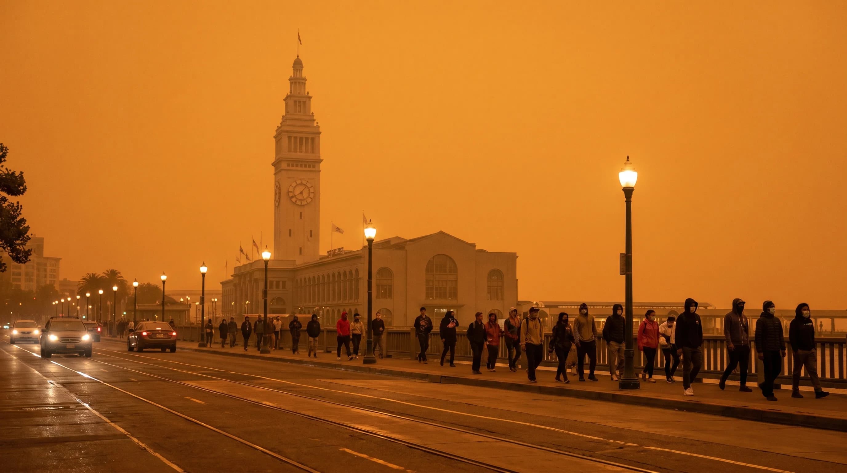
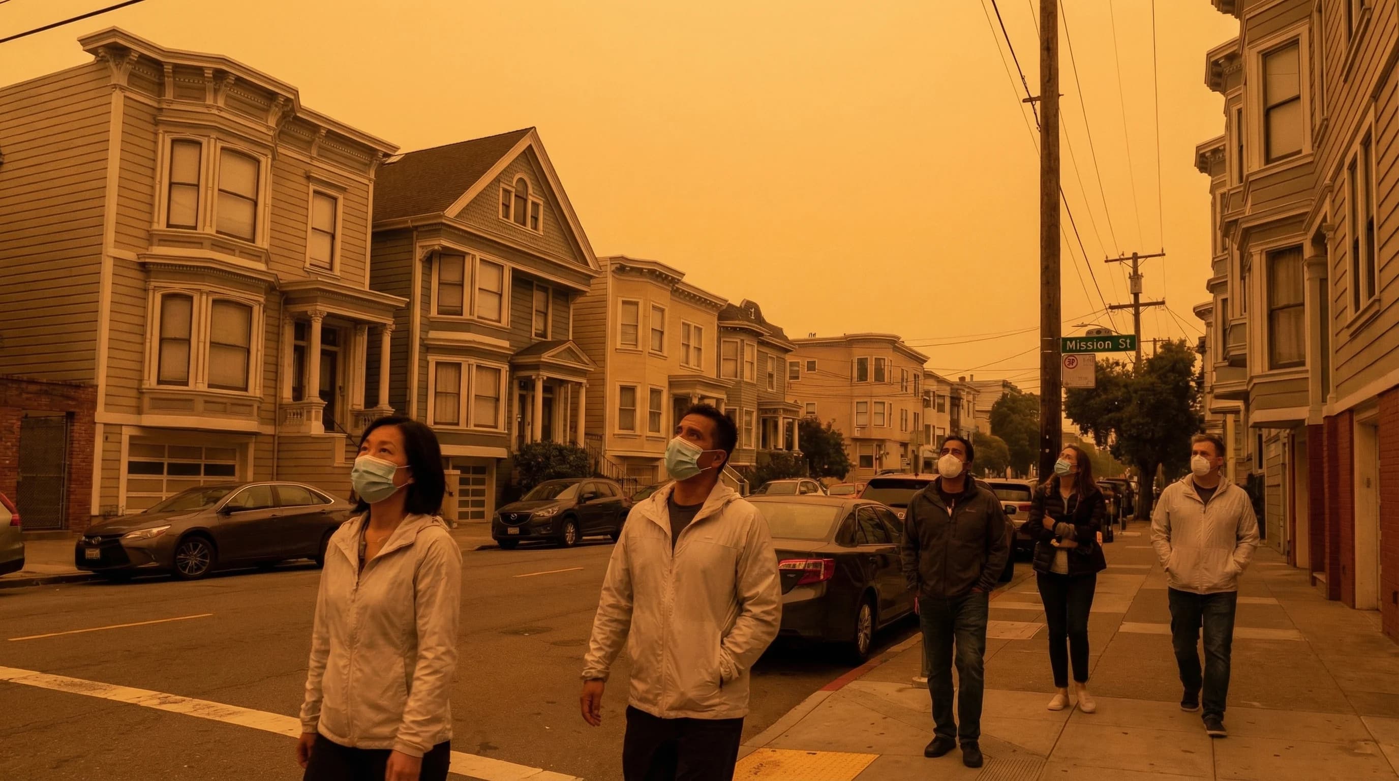
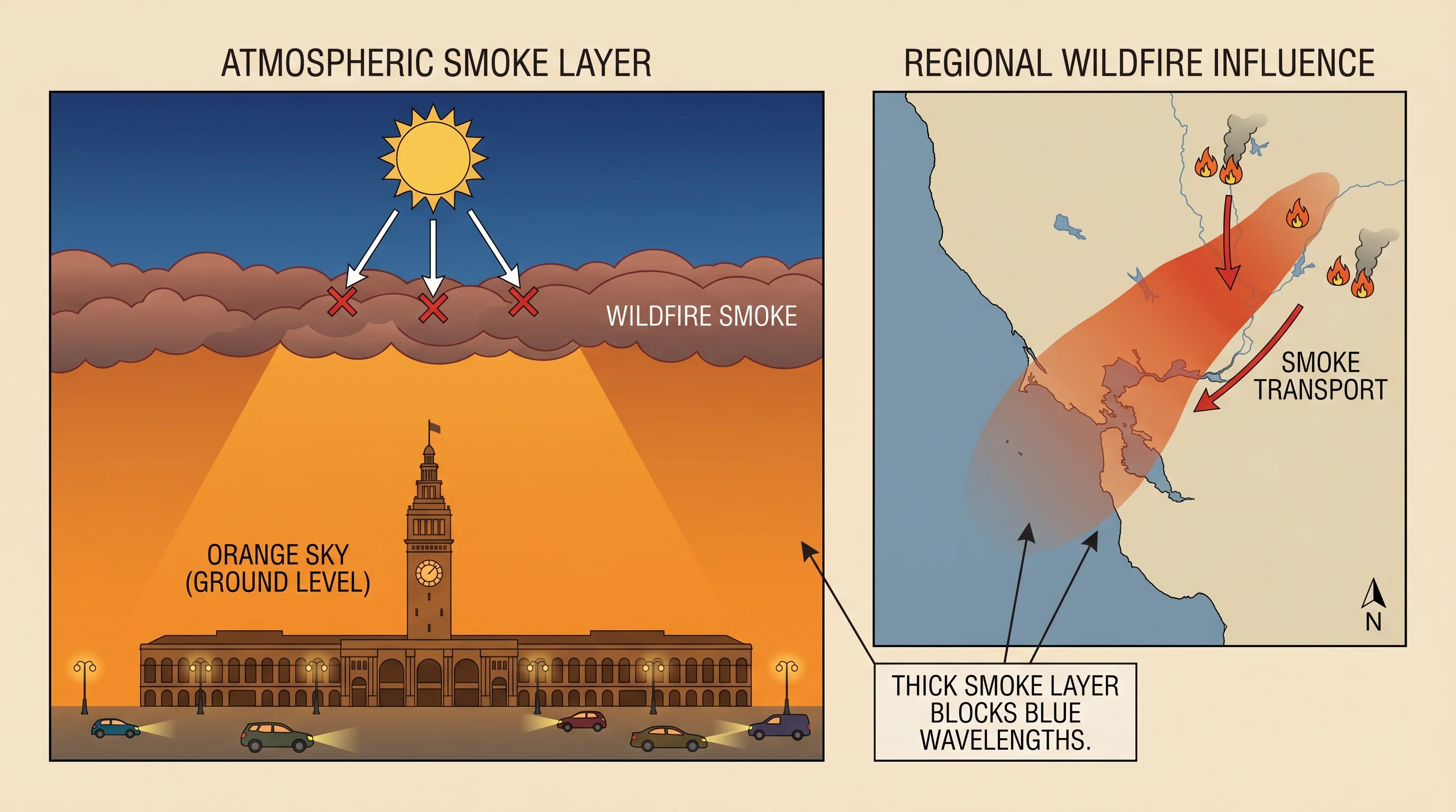
Three of the ignitions became massive complexes. The SCU Lightning Complex in the Diablo Range east of the Bay Area burned more than 396,000 acres. The LNU Lightning Complex in the North Bay wine country burned more than 363,000 acres, destroying neighborhoods in Vacaville and forcing evacuations across Napa and Sonoma counties. The CZU Lightning Complex in the Santa Cruz Mountains burned more than 86,000 acres and forced evacuation of more than 75,000 people. The sky over the Bay Area turned orange. Air quality reached hazardous levels that exceeded the scale of most measuring instruments. Schools closed, outdoor activities were canceled, and residents were advised to stay indoors.

Lessons and Legacy

The 2020 heat dome and Lightning Siege accelerated changes in how California manages fire risk, power grid reliability, and extreme heat preparedness. PG&E's power shutoffs in extreme weather conditions, already in place following the 2018 Camp Fire, were refined. The state invested in additional prescribed burn capacity and forest management. Cooling center protocols were updated. The California Department of Forestry and Fire Protection expanded its air attack and ground crew capacity.

The deeper lesson of August 2020 is about interaction effects. The heat dome alone would have been a serious but manageable event. The lightning siege alone would have been serious. The smoke alone would have been serious. The power grid strain alone would have been serious. Combined, they created a week where the region's multiple protective and response systems were overwhelmed simultaneously. Climate scientists use the 2020 event as a reference case for compound extreme events, situations where multiple climate-related stresses occur together, producing outcomes far worse than any single stressor would produce alone.

Frequently Asked Questions

How hot did it get during the 2020 Bay Area heat dome?

The August 2020 heat dome broke temperature records throughout the Bay Area. Concord recorded 116°F. Livermore reached 115°F. San Jose hit 105°F. Santa Rosa recorded 111°F. Death Valley hit 130°F, the highest reliably recorded temperature in world history. Even San Francisco, which rarely exceeds the mid-80s, approached the high 90s and above during the event. The heat lasted for multiple days, with minimal overnight cooling.

What was the Lightning Siege of 2020?

The Lightning Siege was a mass ignition event triggered by dry lightning during the August 2020 heat dome. As unstable, overheated air collided with monsoonal moisture from the southwest, thunderstorms formed and produced more than 10,000 lightning strikes over 72 hours. An estimated 560 fires ignited simultaneously. Three grew into massive complexes: the SCU Lightning Complex (396,000+ acres east of the Bay Area), the LNU Lightning Complex (363,000+ acres in the North Bay wine country), and the CZU Lightning Complex (86,000+ acres in the Santa Cruz Mountains).

Why did the sky turn orange in September 2020?

On September 9, 2020, smoke from the Lightning Siege fires; particularly from the LNU, SCU, and CZU Complexes; combined with particulate from dozens of other fires burning across Northern California. The smoke column blocked direct sunlight but allowed longer-wavelength red and orange light to pass through, turning the midday sky a deep, eerie orange. Air quality sensors recorded AQI values beyond their maximum measurement scale. The orange sky persisted for most of the day across the Bay Area.

What caused the rolling blackouts during the 2020 heat dome?

The rolling blackouts on August 14-15, 2020 were the first rotating outages in California since the 2001 energy crisis. Demand for air conditioning surged across the state as temperatures exceeded 100°F in areas that normally never approach those readings. At the same time, solar power output dropped in the late afternoon as the sun set, and power imports from neighboring states were unavailable; those states were also experiencing extreme heat and their own grid stress. The grid operator, CAISO, ordered utilities to shed load to prevent a larger uncontrolled collapse.

How does the 2020 event compare to other Bay Area heat events?

The 2020 heat dome was the Bay Area's most extreme compound weather event in modern recorded history. It was not just the hottest temperatures on record; Concord 116°F, Livermore 115°F, Santa Rosa 111°F; but the simultaneous occurrence of record heat, a mass fire ignition event, smoke-driven air quality emergencies, and grid failure. No previous event combined all of these stresses at once. The August 2020 event is now a case study in what climate scientists call a "compound extreme event," where multiple climate risks converge to produce outcomes worse than any single event would.

Live Bay Area Conditions

Compare fog, temperature, wind, and comfort across the map.

See which microclimates are clear, cool, windy, or warming up right now.

Open the Weather Map
🔒Privacy Policy📄Terms of Service