The urban heat island effect is one of the most well-documented phenomena in climate science, and the Bay Area provides some of its most interesting case studies, not because the effect is especially strong here, but because it interacts with the marine layer in ways that produce counterintuitive results. In most American cities, urban areas are warmer than the surrounding countryside. In the Bay Area, the relationship is more complicated: dense urban neighborhoods can be warmer than adjacent parks on calm evenings, but the marine layer's influence often overwhelms the urban heat signature entirely. The result is a coastal fog city where the urban heat island effect plays out differently than almost anywhere else.
What Causes Urban Heat Islands
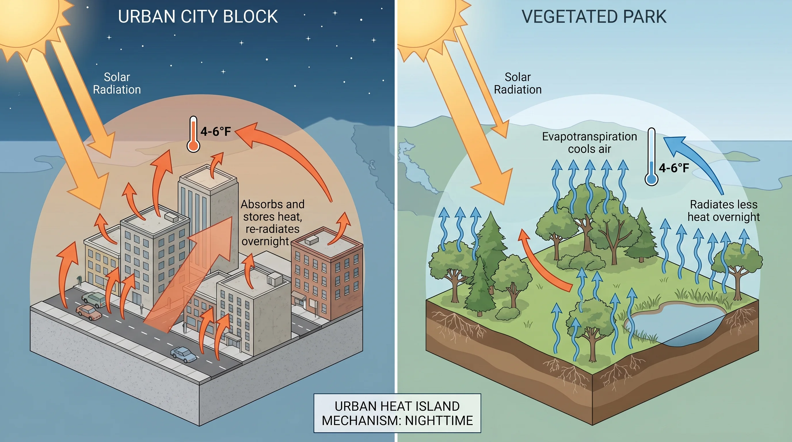
Urban heat islands form because cities replace vegetated, permeable surfaces with materials that absorb and retain heat differently. Asphalt, concrete, and rooftops absorb solar radiation during the day and release it slowly after dark, keeping urban areas warmer through the night than surrounding open land. The absence of vegetation means less evapotranspiration, the cooling process by which plants release moisture. Tall buildings trap heat by limiting longwave radiation to the sky. And human activity, vehicles, air conditioning, and industry, adds heat directly to the urban environment.
In a typical inland American city, these factors combine to produce an urban-rural temperature difference of 2 to 10 degrees Fahrenheit, most pronounced on calm, clear nights. The effect is weakest during the day when solar heating dominates everywhere, and strongest after sunset when the city continues releasing stored heat while rural areas cool rapidly.
How the Marine Layer Modifies the Urban Heat Island
San Francisco's marine layer fundamentally changes the urban heat island dynamic. During summer, when the marine layer is thick, it acts as a blanket that limits both daytime solar heating and nighttime radiative cooling across the entire city. The urban heat island relies on daytime solar absorption, but on foggy summer days, the city absorbs much less solar radiation than it would under clear skies. At the same time, the marine layer reduces the radiative cooling that allows rural areas to cool faster than the city at night.
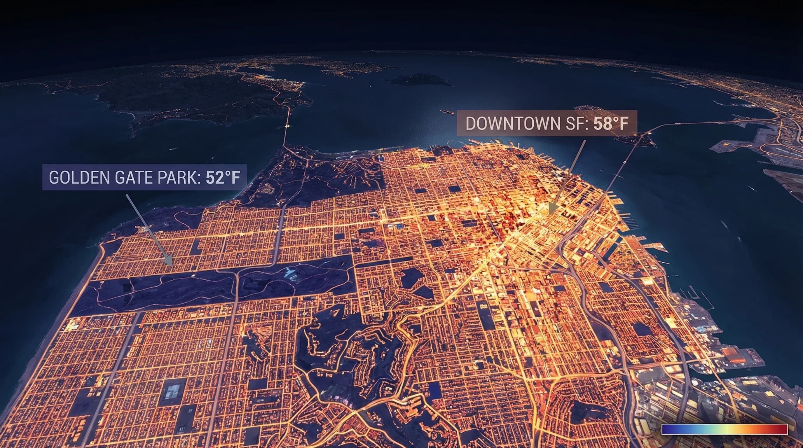
The result is that San Francisco's urban heat island is most apparent on the occasions when it is least expected: clear winter days and nights, when solar heating is unimpeded and nighttime sky conditions are clear enough for differential cooling. On these days, dense downtown neighborhoods can run 4 to 6 degrees Fahrenheit warmer overnight than the city's parks and open spaces. Golden Gate Park, with its large vegetated area, acts as a cool island within the urban environment on clear nights.
Neighborhood Variation Within San Francisco
Within San Francisco, the urban heat island effect interacts with the city's microclimate geography in ways that amplify some neighborhood temperature differences and mask others. The Mission District, already warmer than the Outer Sunset because of the fog shadow created by Twin Peaks, also has a denser urban fabric and less street tree cover than some other neighborhoods, contributing to additional urban heat retention. On summer evenings, the Mission can be 8 to 10 degrees warmer than Ocean Beach, a gap that combines fog shadow effects with a real urban heat contribution.
Conversely, the Outer Sunset and Outer Richmond, while exposed to more fog and wind, have lower building density and more permeable surfaces than downtown. The urban heat island effect is weaker in these neighborhoods than in the dense downtown core. The net effect of all these overlapping factors is that San Francisco's neighborhood temperature variation is driven primarily by fog shadow geography, secondarily by urban heat, and these two forces sometimes align (Mission warm for both reasons) and sometimes work in opposite directions.
The East Bay: Where Urban Heat Islands Are More Visible
The urban heat island effect is more clearly visible in East Bay cities like Oakland, Fremont, and San Jose, where the marine layer is weaker and the contrast between urban surfaces and natural open space is sharper. Oakland's dense urban core runs noticeably warmer on summer nights than the adjacent hills and parks. The East Bay hills, with their open grasslands and woodlands, cool rapidly on clear nights while the urban flatlands retain heat from the day.
San Jose, at the southern end of the Bay, provides one of the clearest Bay Area examples of urban heat island effects. The city has grown dramatically over the past fifty years, converting orchard and farmland to impervious urban surfaces. This conversion has been linked to measurable increases in overnight low temperatures in the urban core relative to surrounding agricultural and open areas. During heat waves, the urban heat island amplifies already dangerous temperatures in San Jose's most densely developed neighborhoods.
The urban heat island effect is not the Bay Area's dominant climate story. The marine layer and microclimate geography are far more powerful forces. But it is a real and measurable layer of complexity that sits on top of those larger patterns, making cities a degree or two warmer than their surroundings on calm nights, and making San Francisco's parks and open spaces cooler refuges than the immediately adjacent streets might suggest.