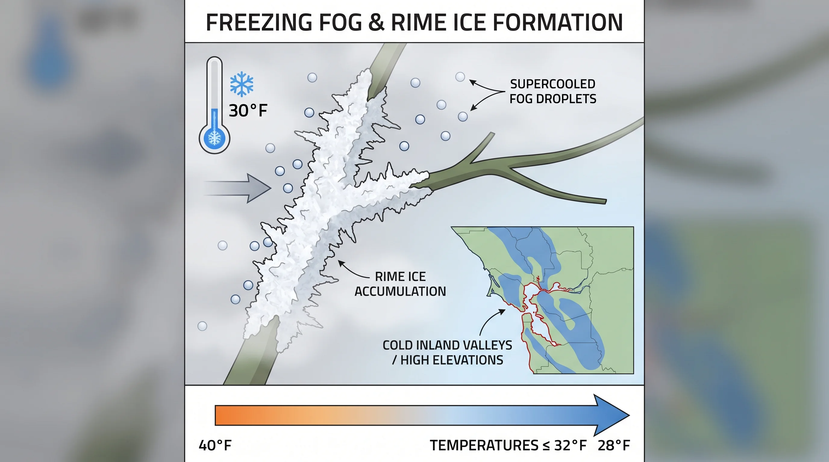
Freezing fog is fog that occurs when air temperatures are at or below 32 degrees Fahrenheit, causing the fog's suspended water droplets to freeze on contact with surfaces. It is rare in the Bay Area, where mild Pacific air keeps temperatures above freezing through most of the year at coastal and low-elevation locations. But it does occur, and when it does, it produces one of the more visually striking weather phenomena in the region: surfaces coated in rime ice, a white crystalline frost formed entirely from fog rather than from freezing rain or overnight dew. The Bay Area locations most likely to experience freezing fog are its highest elevations and its coldest inland valleys during exceptional cold snaps.
How Freezing Fog Forms
Standard fog is composed of liquid water droplets suspended in air. Even at temperatures slightly below freezing, these droplets can remain liquid in a supercooled state, because liquid water does not freeze instantly at 32 degrees unless it has a surface or nuclei to freeze onto. When supercooled fog droplets contact a solid surface, such as a tree branch, a car, a power line, or the ground, they freeze on contact. This produces rime ice, a rough, white, opaque coating of ice that accumulates on the windward side of objects exposed to the fog.
The process is different from hoarfrost, which forms by deposition: water vapor going directly from gas to ice without passing through a liquid phase. Rime from freezing fog is denser and whiter than hoarfrost, and it accumulates in the direction the fog is moving, coating surfaces facing into the airflow. It is also different from freezing rain or sleet, which involves precipitation falling from above. Freezing fog creates ice from the fog itself, accumulating slowly and without any falling precipitation.
Where Freezing Fog Occurs in the Bay Area
The Bay Area's mild climate means temperatures rarely drop to freezing at coastal or low-elevation locations, even on the coldest winter nights. Freezing fog is most likely at two types of locations: high-elevation summits and unusually cold inland valleys.
At high elevation, Mount Hamilton (4,265 feet) and the upper reaches of Mount Diablo (3,849 feet) experience freezing temperatures on many winter nights. When radiation fog or stratus forms at these elevations, or when advection fog is thick enough to reach these heights, freezing fog conditions can develop. The Lick Observatory at the summit of Mount Hamilton sits in freezing fog conditions several times each winter, and the road to the summit can become slick with rime ice.
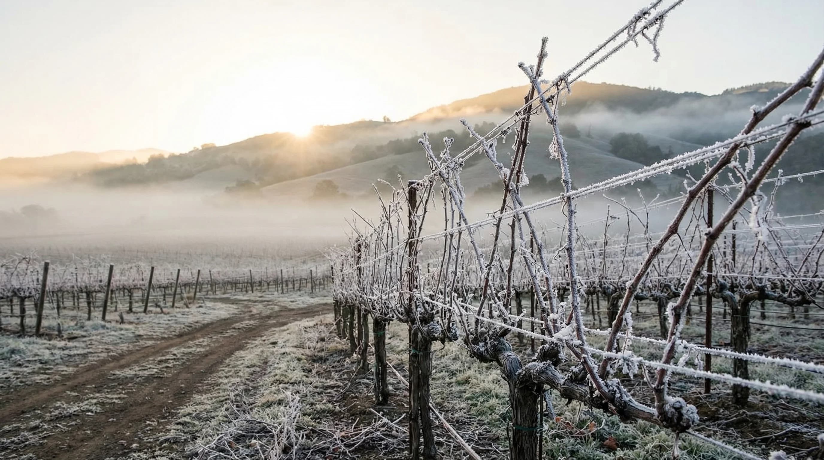
In the inland valleys, the Livermore Valley and parts of the Napa and Sonoma valleys see temperatures below 32 degrees on the coldest winter nights. When radiation fog forms in these valleys during such nights, the combination of fog and below-freezing temperatures produces freezing fog. The fog itself may be light and visually thin, but the accumulated rime on vehicles, vegetation, and surfaces can be significant by morning.
Freezing Fog Hazards and Safety
Freezing fog creates road hazards that are less obvious than snow or ice from freezing rain. Because no precipitation falls, roads may appear wet or merely damp rather than icy. But bridges, overpasses, and exposed elevated road surfaces can accumulate a thin glaze of ice from freezing fog droplets. This black ice effect is particularly dangerous because drivers have no visual warning. Bay Area drivers, unaccustomed to winter driving hazards, are at heightened risk when freezing fog is forecast.
The National Weather Service issues Dense Fog Advisories that cover visibility, but freezing fog creates an additional hazard beyond visibility reduction. When temperatures are at or below 32 degrees and fog is present, treat all elevated road surfaces and bridges as potentially icy regardless of their appearance. This is especially relevant on roads to the Bay Area's summits: the Mount Hamilton road and the upper portion of Mount Diablo's summit road can become treacherous during freezing fog events.
What Freezing Fog Looks Like in the Bay Area
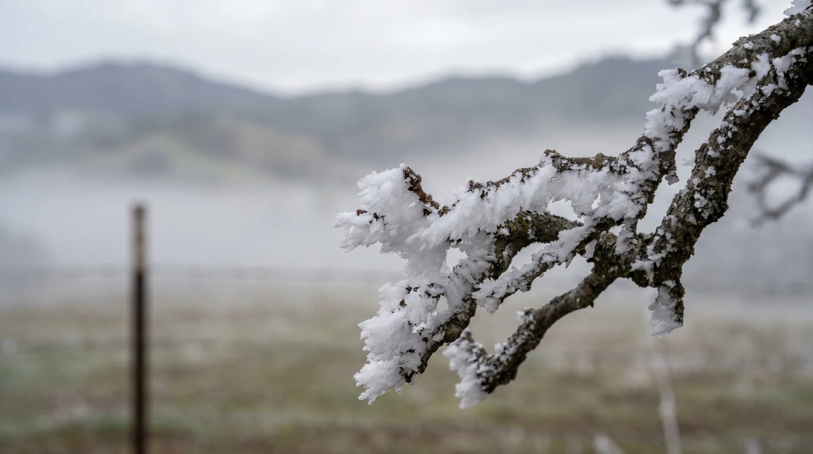
After a night of freezing fog, the visual effect on vegetation can be striking. Grass, tree branches, fence posts, and any exposed surface facing the direction of airflow accumulate a white crystalline coating. In the Napa and Livermore valleys, winter mornings after freezing fog events look almost as if light snow has fallen, with every exposed surface frosted in white rime. In vineyard country, the dormant vines become white sculptures, and the fog's passage through the valley is recorded in the ice patterns on every surface it touched.
As temperatures rise above freezing through the morning, the rime melts quickly, often leaving surfaces dripping without any precipitation having fallen. The transition from a white, rime-coated landscape to a clear, damp one can happen within an hour as the sun heats the surface. It is one of the more unusual and beautiful weather sequences in the Bay Area winter, and it occurs almost exclusively in the inland valleys and at high elevations where temperatures can actually reach the freezing threshold.