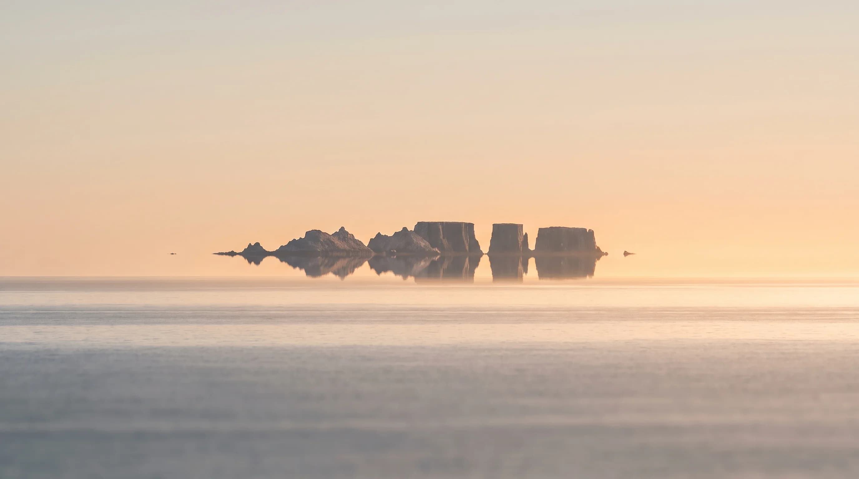
A Fata Morgana is a complex mirage that stretches, stacks and flips distant objects near the horizon. It forms when a layer of warm air sits over cold ocean and bends light. San Francisco's summer marine inversion is the setup: over Oakland, afternoon inversions of 5°C (9°F) or more occur on about 8 of 10 July days.
About 30 miles west of the Golden Gate, the Farallon Islands sometimes look like a floating city. The catch is that the same layer that makes them float also makes Karl the Fog.
What Is a Fata Morgana?
A Fata Morgana is a superior mirage that shows up in a thin band just above the horizon. Distant islands or ships appear stretched into tall columns, squashed flat, or stacked with upside-down copies, and the picture shifts from minute to minute. The name comes from Morgan le Fay, the sorceress of Arthurian legend.
Mirages like this have fooled sailors for centuries. Australia's Bureau of Meteorology notes that the legend of the Flying Dutchman, a ghost ship seen sailing in the sky, is thought to be a Fata Morgana: a strong inversion can bend light from a ship that is actually below the horizon, so it appears to float above the sea.
The mirage needs a layer of warm air sitting on top of cold ocean air, and San Francisco has that all summer.
Why Do the Farallon Islands Seem to Float?
The Farallon Islands seem to float because light from them bends as it passes through a steep temperature inversion, warm air above cool air, on its way to your eye. The bent light makes the islands look higher than they are, and in a strong inversion it can stretch and stack them into a Fata Morgana.
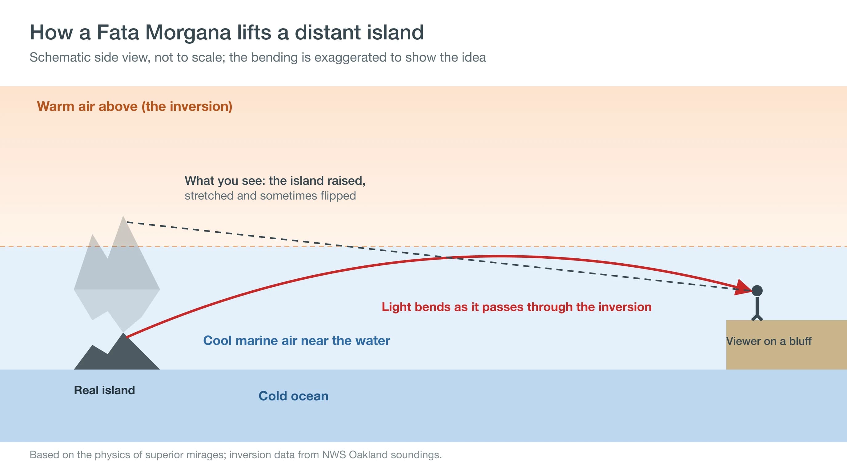
The inversion is the lid on San Francisco's marine layer, the same lid that traps summer fog along the coast. Learn more about temperature inversions in the Bay Area. Weather balloons show how often the layer is in place, and why that is only half the story.
Why Do Mirages Hide in the Foggiest Months?
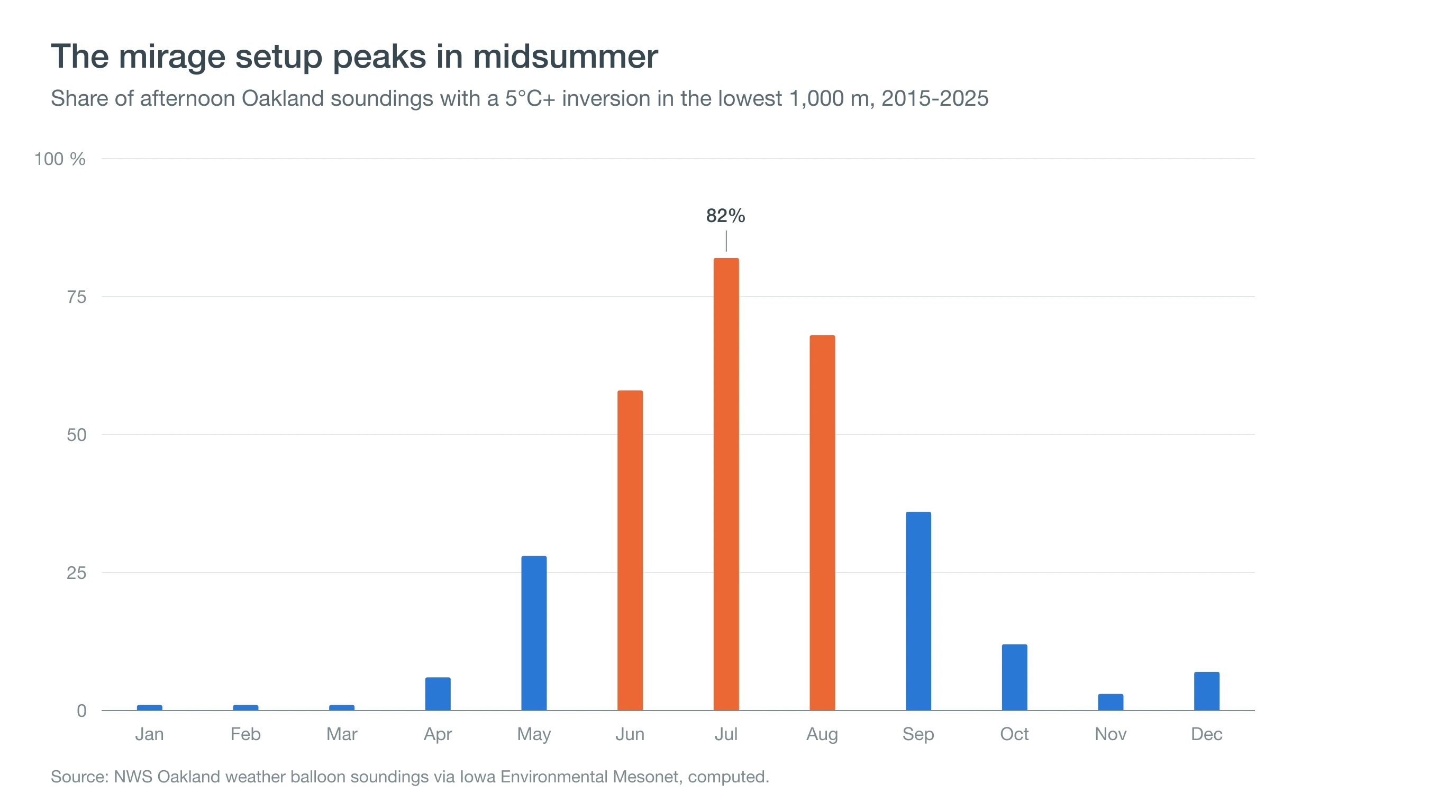
Mirages hide in the foggiest months because the inversion and the fog come together. Our analysis of afternoon weather balloons launched from Oakland from 2015 to 2025 found an inversion of 5°C or more in the lowest 1,000 meters on 82% of July days and 68% of August days, but those are also the months when fog most often covers the coast.
| Month | Inversion 5°C+ | Inversion 8°C+ | Typical strength | What to expect |
|---|---|---|---|---|
| January | 1% | 0% | 0.2°C | Very rare |
| February | 1% | 0% | 0°C | Very rare |
| March | 1% | 0% | 0°C | Very rare |
| April | 6% | 1% | 0.6°C | Rare |
| May | 28% | 9% | 2.2°C | Mirages start; often clearer than summer |
| June | 58% | 31% | 6.0°C | Common setup; fog may hide the horizon |
| July | 82% | 51% | 8.0°C | Strongest inversions; often foggy at the coast |
| August | 68% | 33% | 6.7°C | Strong setup; watch for clear afternoons |
| September | 36% | 14% | 3.1°C | Clearer horizons on warm days |
| October | 12% | 3% | 0.6°C | Occasional |
| November | 3% | 0% | 0.2°C | Rare |
| December | 7% | 2% | 0.4°C | Rare |
Share of afternoon (00 UTC, about 4-5 PM local) NWS weather balloon soundings at Oakland with a temperature increase of at least 5°C or 8°C within the lowest 1,000 meters, 2015-2025, via the Iowa Environmental Mesonet. Typical strength is the median temperature rise across all afternoons that month.
Strength matters as much as frequency. On a typical July afternoon, the air a few hundred meters up is about 8°C (14°F) warmer than the air at the surface; in winter the typical difference is close to zero. A Fata Morgana needs a steep rise packed into a thin layer, and summer is the only season that delivers it often.
So the real question is when the inversion holds but the horizon clears.
When Is Your Best Chance to See One?
Your best chance is a clear afternoon with a strong inversion, which tends to happen in late spring, in late summer into September, and on hot days when the fog stays offshore. A good sign is fog lying out at sea while the coast is sunny.
Heat waves are worth watching in particular. When hot air spreads over the coast but the ocean stays cold, the inversion can be very strong and close to the water, and the fog bank often sits offshore instead of on the beach. For how those setups form, see Bay Area heat domes.
Mirages also fade toward sunset as the air near the water changes; one well-known photo sequence of the Farallones shows a Fata Morgana turning into a simpler mirage by evening. Timing gets the air right; the viewpoint gets your eyes above the haze.
Where Can You See the Farallon Islands From?
You can see the Farallon Islands from high, west-facing spots on the San Francisco coast, including Lands End, the bluffs above Ocean Beach, Twin Peaks and the Point Reyes Lighthouse. Binoculars or a long lens help. The islands are a national wildlife refuge closed to the public.
You can see the islands at all because they are tall. Southeast Farallon, the largest, rises to about 357 feet at Lighthouse Hill, so its upper slopes poke above the horizon even though the curve of the Earth hides the waterline from about 30 miles away. On a mirage day, the inversion lifts the image further, which is why the islands can suddenly look taller, closer or stacked.
Once you are looking, you need to know what counts as a mirage.
What Other Mirages Can You See Around the Bay Area?
The most common mirage is the opposite kind: the shimmering "water" on a hot road. That is an inferior mirage, which forms when pavement heats the air just above it. Light from the sky bends upward through the hot, thin layer, so you see a reflection of the sky on the road, especially on long, straight inland highways on hot afternoons.
A Fata Morgana is a superior mirage, the kind that needs cold air below and warm air above, so it belongs to the coast and the bay. Ships approaching the Golden Gate and the distant Marin Headlands can look lifted or stretched on strongly inverted afternoons. If the shape shifts and stacks, you are looking through the same layer that makes the Farallones float.
How Do You Photograph a Fata Morgana?
You photograph a Fata Morgana with the longest lens you have and a steady support. The islands are about 30 miles away, so a phone's main camera shows only a speck; a telephoto lens or a phone's zoom on a small tripod makes the stretching and stacking visible.
Shoot a sequence rather than a single frame, because the mirage can change shape from one minute to the next. Note the time and, if you can, take a photo of the same view on an ordinary day for comparison. Side-by-side pictures are the clearest way to show that the islands really did change shape.
Deep Dive: How Does Air Bend Light Into a Mirage?
Air bends light because its refractive index depends on density, and density depends on temperature. Cold air is denser and has a slightly higher index than warm air, so a light ray crossing layers of different temperature curves toward the colder, denser air. The change is only about one millionth per degree Celsius, but over tens of miles of nearly horizontal path it adds up to visible distortion.
What Happens on an Ordinary Day?
On an ordinary day, air thins with height and light curves gently downward. Surveyors model this standard refraction as bending light along an arc with a radius roughly seven to eight times Earth's, enough to let you see a little past the geometric horizon. By our calculation, an observer 100 feet above the water looking at Southeast Farallon, about 27 miles west of the Golden Gate, normally has roughly the bottom 110 feet of the island hidden below the horizon; only the upper part of its 357-foot peak shows.
When Does Light Follow the Curve of the Earth?
Inside a strong inversion, temperature rises with height, so density falls off faster than usual and rays bend downward more sharply. Atmospheric optics researchers put the threshold for ducting at a rise of roughly 11°C per 100 meters (about 6°F per 100 feet): beyond that, rays curve more tightly than Earth itself and stay trapped in the layer. Mirage researchers note that an observer generally needs to be within or just below such a duct to see a Fata Morgana.
The Oakland balloon data puts that number in context. A typical July inversion of about 8°C spread over a few hundred meters averages only about 2°C to 4°C per 100 meters, well short of ducting. The mirage appears when much of that rise is packed into a thin layer near the surface, such as 8°C in 60 meters, and when that layer sits close to the observer's eye level.
Why Do the Images Stack and Flip?
Multiple images form because rays from one point on the island reach your eye along more than one path, some arching through the duct and some passing beneath it. Each path produces its own image, upright or inverted, and the eye sees them stacked one above another. As the layer ripples, the paths change, and the stack shifts from minute to minute.
Knowing the optics also helps you rule out the impostors.
How Can You Tell a Mirage From Fog, Haze or a Ship?
A mirage changes shape minute to minute, stacks or flips images, and sits in a thin band on the horizon. Fog looks like a gray wall, and haze softens everything evenly; see haze vs. fog. If the shape is shifting and stacked, you are seeing the fog's setup without the fog.
You want the inversion without the fog. Check the Bay Area fog forecast for a clear coast with fog offshore, then head to Lands End with binoculars an hour or two before sunset. For the wind side of the story, see Bay Area sea breezes.